
Search Constraints
You searched for:
Campus
IUB
Remove constraint Campus: IUB
Frame Number
2
Remove constraint Frame Number: 2
Pages
0-99 pages
Remove constraint Pages: 0-99 pages
Subject
Trees
Remove constraint Subject: Trees
Subject
Mountains
Remove constraint Subject: Mountains
1 - 51 of 51
Search Results
-
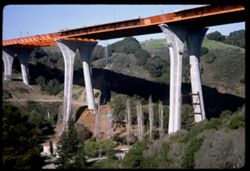
- Description:
- 100 f 11
- Subject:
- Valleys, Houses, Trees, Bridge construction, Mountains, Bridges, Utility poles, Canyons, and Roads
- Series:
- 1-67
- Creator:
- Cushman, Charles W., 1896-1972
- Date Created:
- 1967-03-07
- Genre:
- Architectural photographs
- Frame Number:
- 2
- Street Address:
- California State Highway 280 and Junipero Serra Freeway
- County:
- San Francisco
- Abstract:
- New high bridge over canyon
- Call Number:
- P15479
- City:
- San Francisco
- Country:
- United States
- State/Province:
- California
- Alternate Identifier:
- 167.2
- Persistent URL:
- http://purl.dlib.indiana.edu/iudl/archives/cushman/P15479
- Holding Location:
- Bloomington - University Archives
Wells Library E460
1320 E 10th St.
Bloomington, IN 47405
Contact at archives@indiana.edu, 812-855-1127
-
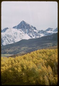
- Description:
- 100 f 11 TL
- Subject:
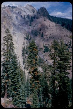
- Uncompahgre National Forest (Colo.), Forests, Mountains, Snow, and Trees
- Series:
- 36-65
- Creator:
- Cushman, Charles W., 1896-1972
- Date Created:
- 1965-10-05
- Genre:
- Landscape photographs
- Frame Number:
- 2
- Street Address:
- Colorado State Highway 62
- County:
- Ouray and San Miguel
- Abstract:
- Nr. Mt Sneffels (14150') from Colo. Hwy 62, San Miguel county.
- Call Number:
- P15070
- Country:
- United States
- State/Province:
- Colorado
- Alternate Identifier:
- 3665.2
- Persistent URL:
- http://purl.dlib.indiana.edu/iudl/archives/cushman/P15070
- Holding Location:
- Bloomington - University Archives
Wells Library E460
1320 E 10th St.
Bloomington, IN 47405
Contact at archives@indiana.edu, 812-855-1127
-
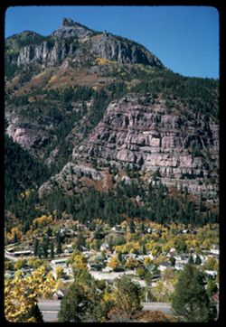
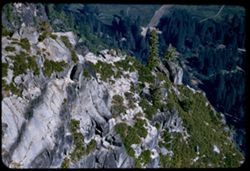
- Description:
- 100 f 11
- Subject:
- Cliffs, Trees, Cities & towns, Buildings, Forests, Roads, Houses, and Mountains
- Series:
- 35-65
- Creator:
- Cushman, Charles W., 1896-1972
- Date Created:
- 1965-10-04
- Genre:
- Landscape photographs and Cityscape photographs
- Frame Number:
- 2
- County:
- Ouray
- Abstract:
- Ouray = cliff NW.
- Call Number:
- P15032
- City:
- Ouray
- Country:
- United States
- State/Province:
- Colorado
- Alternate Identifier:
- 3565.2
- Persistent URL:
- http://purl.dlib.indiana.edu/iudl/archives/cushman/P15032
- Holding Location:
- Bloomington - University Archives
Wells Library E460
1320 E 10th St.
Bloomington, IN 47405
Contact at archives@indiana.edu, 812-855-1127
-
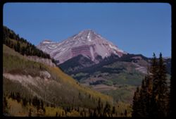
- Description:
- 100 f 16 tl
- Subject:
- Snow, Cliffs, Trees, Mountains, and Forests
- Series:
- 33-65
- Creator:
- Cushman, Charles W., 1896-1972
- Date Created:
- 1965-10-02
- Genre:
- Landscape photographs
- Frame Number:
- 2
- Street Address:
- United States Highway 550
- County:
- San Juan and La Plata
- Abstract:
- Snow covered Mtn
- Call Number:
- P14957
- City:
- Durango and Silverton
- Country:
- United States
- State/Province:
- Colorado
- Alternate Identifier:
- 3365.2
- Persistent URL:
- http://purl.dlib.indiana.edu/iudl/archives/cushman/P14957
- Holding Location:
- Bloomington - University Archives
Wells Library E460
1320 E 10th St.
Bloomington, IN 47405
Contact at archives@indiana.edu, 812-855-1127
-
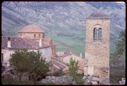
- Subject:
- Bell towers, Valleys, Monasteries, Hosios Loukas (Monastery : Voiotia, Greece), Trees, Roofs, Mountains, and Domes
- Series:
- 12-65
- Creator:
- Cushman, Charles W., 1896-1972
- Date Created:
- 1965-04-21
- Genre:
- Cityscape photographs and Architectural photographs
- Frame Number:
- 2
- County:
- Voiotia
- Call Number:
- P14240
- Country:
- Greece
- State/Province:
- Central Greece and Euboea
- Alternate Identifier:
- 1265.2
- Persistent URL:
- http://purl.dlib.indiana.edu/iudl/archives/cushman/P14240
- Holding Location:
- Bloomington - University Archives
Wells Library E460
1320 E 10th St.
Bloomington, IN 47405
Contact at archives@indiana.edu, 812-855-1127
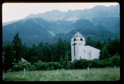
-
- Description:
- 50 f 5.6
- Subject:
- Wildflowers, Spires, Hungerburg (Austria), Trees, Meadows, Cable railroads, Religious architectural elements, Mountains, Fences, Clock towers, Forests, Nordk...
- Series:
- 17-64
- Creator:
- Cushman, Charles W., 1896-1972
- Date Created:
- 1964-06-07
- Genre:
- Landscape photographs
- Frame Number:
- 2
- Abstract:
- Cable cars below Nordkette
- Call Number:
- P13543
- City:
- Innsbruck
- Country:
- Austria
- State/Province:
- Tyrol
- Alternate Identifier:
- 1764.2
- Persistent URL:
- http://purl.dlib.indiana.edu/iudl/archives/cushman/P13543
- Holding Location:
- Bloomington - University Archives
Wells Library E460
1320 E 10th St.
Bloomington, IN 47405
Contact at archives@indiana.edu, 812-855-1127
-
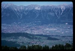
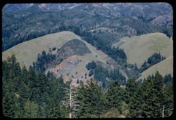
- Description:
- 100 f 11
- Subject:
- Trees, Cities & towns, Forests, Alps, Austrian (Austria), Patscherkofel (Austria), Mountains, and Croplands
- Series:
- 15-64
- Creator:
- Cushman, Charles W., 1896-1972
- Date Created:
- 1964-06-04
- Genre:
- Landscape photographs and Cityscape photographs
- Frame Number:
- 2
- Call Number:
- P13467
- City:
- Innsbruck
- Country:
- Austria
- State/Province:
- Tyrol
- Alternate Identifier:
- 1564.2
- Persistent URL:
- http://purl.dlib.indiana.edu/iudl/archives/cushman/P13467
- Holding Location:
- Bloomington - University Archives
Wells Library E460
1320 E 10th St.
Bloomington, IN 47405
Contact at archives@indiana.edu, 812-855-1127
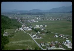
-
- Description:
- 200 f 5.6
- Subject:
- Meadows, Streets, Hills, Untersberg (Austria), Mountains, Trees, Buildings, and Houses
- Series:
- 9-64
- Creator:
- Cushman, Charles W., 1896-1972
- Date Created:
- 1964-05-24
- Genre:
- Landscape photographs and Cityscape photographs
- Frame Number:
- 2
- Abstract:
- Cable ride up
- Call Number:
- P13242
- City:
- Salzburg
- Country:
- Austria
- State/Province:
- Salzburg
- Alternate Identifier:
- 964.2
- Persistent URL:
- http://purl.dlib.indiana.edu/iudl/archives/cushman/P13242
- Holding Location:
- Bloomington - University Archives
Wells Library E460
1320 E 10th St.
Bloomington, IN 47405
Contact at archives@indiana.edu, 812-855-1127
-
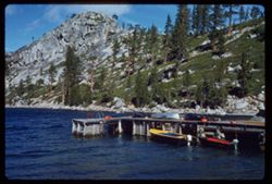
- Description:
- 100 f 5.6 SL
- Subject:
- Lakes & ponds, Mountains, Waterfronts, Boats, Sierra Nevada (Calif. and Nev.), Trees, Rocks, Rock formations, and Piers & wharves
- Series:
- 3-62
- Creator:
- Cushman, Charles W., 1896-1972
- Date Created:
- 1962-09-28
- Genre:
- Marine photographs and Landscape photographs
- Frame Number:
- 2
- County:
- El Dorado
- Abstract:
- Echo Lake.
- Call Number:
- P12700
- City:
- Echo Lake
- Country:
- United States
- State/Province:
- California
- Alternate Identifier:
- 362.2
- Persistent URL:
- http://purl.dlib.indiana.edu/iudl/archives/cushman/P12700
- Holding Location:
- Bloomington - University Archives
Wells Library E460
1320 E 10th St.
Bloomington, IN 47405
Contact at archives@indiana.edu, 812-855-1127
-

- Description:
- 100 f 4
- Subject:
- Neckar River (Germany), Streets, Street lights, Arches, Bridges, Sidewalks, Trees, Buildings, Vehicles, Strollers (Baby carriages), Rivers, Mothers & chi...
- Series:
- 17-60
- Creator:
- Cushman, Charles W., 1896-1972
- Date Created:
- 1960-06-12
- Genre:
- Architectural photographs
- Frame Number:
- 2
- County:
- Karlsruhe
- Abstract:
- Bridge
- Call Number:
- P11420
- City:
- Heidelberg
- Country:
- Germany
- State/Province:
- Baden-Württemberg
- Alternate Identifier:
- 1760.2
- Persistent URL:
- http://purl.dlib.indiana.edu/iudl/archives/cushman/P11420
- Holding Location:
- Bloomington - University Archives
Wells Library E460
1320 E 10th St.
Bloomington, IN 47405
Contact at archives@indiana.edu, 812-855-1127
-
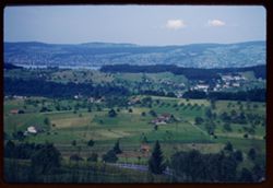
- Description:
- 500 f 2.8
- Subject:
- Houses, Trees, Croplands, Lakes & ponds, Dwellings, Hills, Roads, and Mountains
- Series:
- 16-60
- Creator:
- Cushman, Charles W., 1896-1972
- Date Created:
- 1960-06-06
- Genre:
- Landscape photographs and Cityscape photographs
- Frame Number:
- 2
- Abstract:
- Near Zurich
- Call Number:
- P11388
- City:
- Zurich
- Country:
- Switzerland
- State/Province:
- Zurich
- Alternate Identifier:
- 1660.2
- Persistent URL:
- http://purl.dlib.indiana.edu/iudl/archives/cushman/P11388
- Holding Location:
- Bloomington - University Archives
Wells Library E460
1320 E 10th St.
Bloomington, IN 47405
Contact at archives@indiana.edu, 812-855-1127
-
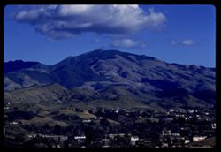
- Description:
- 100 f 8 tl
- Subject:
- Trees, Diablo, Mount (Calif.), Mountains, Buildings, Clouds, and Hills
- Series:
- 1-60
- Creator:
- Cushman, Charles W., 1896-1972
- Date Created:
- 1960-01-12
- Genre:
- Landscape photographs and Cityscape photographs
- Frame Number:
- 2
- Street Address:
- Kirker Pass Road
- County:
- Contra Costa
- Abstract:
- Toward Mt D. from Kirker Pass road From hts west of Walnut Creek toward Diablo
- Call Number:
- P10896
- City:
- Walnut Creek
- Country:
- United States
- State/Province:
- California
- Alternate Identifier:
- 160.2
- Persistent URL:
- http://purl.dlib.indiana.edu/iudl/archives/cushman/P10896
- Holding Location:
- Bloomington - University Archives
Wells Library E460
1320 E 10th St.
Bloomington, IN 47405
Contact at archives@indiana.edu, 812-855-1127
-
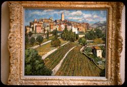
- Description:
- 25 f 1.5
- Subject:
- Walls, Gattiers in Alpes-Maritime, Trees, Fine Arts Museums of San Francisco, Gladys Robinson collection, Retaining walls, Tree limbs, Croplands, Buildings, ...
- Series:
- 13-59
- Creator:
- Cushman, Charles W., 1896-1972
- Date Created:
- 1959-06-17
- Genre:
- Reproductions and Cityscape photographs
- Frame Number:
- 2
- County:
- San Francisco
- Persons Pictured:
- Lachman, Harry, 1886-1975
- Abstract:
- Lachman Gattiers in Alpes Maritime
- Call Number:
- P10800
- City:
- San Francisco
- Country:
- United States
- State/Province:
- California
- Alternate Identifier:
- 1359.2
- Persistent URL:
- http://purl.dlib.indiana.edu/iudl/archives/cushman/P10800
- Holding Location:
- Bloomington - University Archives
Wells Library E460
1320 E 10th St.
Bloomington, IN 47405
Contact at archives@indiana.edu, 812-855-1127
-
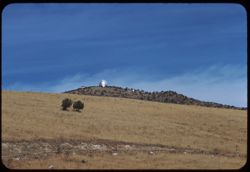
- Description:
- 100 f 8 tl
- Subject:
- Trees, McDonald Observatory, Mountains, Astronomical observatories, Shrubs, and Dwellings
- Series:
- 5-59
- Creator:
- Cushman, Charles W., 1896-1972
- Date Created:
- 1959-01-19
- Genre:
- Landscape photographs
- Frame Number:
- 2
- County:
- Jeff Davis
- Abstract:
- McDonald Observatory atop a Davis Mtn 17,777.7 miles
- Call Number:
- P10503
- City:
- Fort Davis
- Country:
- United States
- State/Province:
- Texas
- Alternate Identifier:
- 559.2
- Persistent URL:
- http://purl.dlib.indiana.edu/iudl/archives/cushman/P10503
- Holding Location:
- Bloomington - University Archives
Wells Library E460
1320 E 10th St.
Bloomington, IN 47405
Contact at archives@indiana.edu, 812-855-1127
-
- Description:
- 50 f 8 sl
- Subject:
- Rocks, Emigrant Gap (Calif. : Gap), Trees, Mountains, and Shrubs
- Series:
- 15-58
- Creator:
- Cushman, Charles W., 1896-1972
- Date Created:
- 1958-08-22
- Genre:
- Landscape photographs
- Frame Number:
- 2
- County:
- Placer
- Abstract:
- East from Emigrant Gap
- Call Number:
- P10108
- Country:
- United States
- State/Province:
- California
- Alternate Identifier:
- 1558.2
- Persistent URL:
- http://purl.dlib.indiana.edu/iudl/archives/cushman/P10108
- Holding Location:
- Bloomington - University Archives
Wells Library E460
1320 E 10th St.
Bloomington, IN 47405
Contact at archives@indiana.edu, 812-855-1127
-
- Description:
- 100 f 8 tl
- Subject:
- Snow, Grasses, Trees, Meadows, Mountains, and Pine Valley Mountain (Utah)
- Series:
- 4-58
- Creator:
- Cushman, Charles W., 1896-1972
- Date Created:
- 1958-04-26
- Genre:
- Landscape photographs
- Frame Number:
- 2
- County:
- Washington
- Abstract:
- Pine Valley Mtn.
- Call Number:
- P09755
- City:
- Saint George
- Country:
- United States
- State/Province:
- Utah
- Alternate Identifier:
- 458.2
- Persistent URL:
- http://purl.dlib.indiana.edu/iudl/archives/cushman/P09755
- Holding Location:
- Bloomington - University Archives
Wells Library E460
1320 E 10th St.
Bloomington, IN 47405
Contact at archives@indiana.edu, 812-855-1127
-
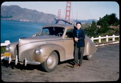
- Description:
- 50 f 8 sl
- Subject:
- Men, Channels, Zephyr automobile, Golden Gate Bridge (San Francisco, Calif.), Suspension bridges, Trees, Mountains, Fences, San Francisco Bay (Calif.), and A...
- Series:
- 1-58
- Creator:
- Cushman, Charles W., 1896-1972
- Date Created:
- 1958-01-13
- Genre:
- Portraits
- Frame Number:
- 2
- County:
- San Francisco
- Persons Pictured:
- Cushman, Charles W. (Charles Weever), 1896-1972
- Abstract:
- old man
- Call Number:
- P09662
- City:
- San Francisco
- Country:
- United States
- State/Province:
- California
- Alternate Identifier:
- 158.2
- Persistent URL:
- http://purl.dlib.indiana.edu/iudl/archives/cushman/P09662
- Holding Location:
- Bloomington - University Archives
Wells Library E460
1320 E 10th St.
Bloomington, IN 47405
Contact at archives@indiana.edu, 812-855-1127
-
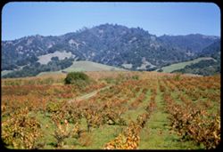
- Description:
- 50 f 6.3 sl
- Subject:
- Grapevines, Dirt roads, Trees, Meadows, Mountains, Grapes, Hills, and Alexander Valley (Calif.)
- Series:
- 16-57
- Creator:
- Cushman, Charles W., 1896-1972
- Date Created:
- 1957-11-05
- Genre:
- Landscape photographs
- Frame Number:
- 2
- Street Address:
- California State Highway 128
- County:
- Sonoma
- Call Number:
- P09568
- Country:
- United States
- State/Province:
- California
- Alternate Identifier:
- 1657.2
- Persistent URL:
- http://purl.dlib.indiana.edu/iudl/archives/cushman/P09568
- Holding Location:
- Bloomington - University Archives
Wells Library E460
1320 E 10th St.
Bloomington, IN 47405
Contact at archives@indiana.edu, 812-855-1127
-
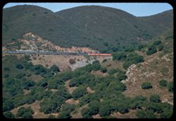
- Description:
- 100 f 4.5 tl
- Subject:
- Cuesta Pass (Calif.), Southern Pacific Railroad Company, Mountains, Shrubs, Railroad passenger cars, Passes (Landforms), Railroads, and Trees
- Series:
- 14-57
- Creator:
- Cushman, Charles W., 1896-1972
- Date Created:
- 1957-09-19
- Genre:
- Landscape photographs and Snapshots
- Frame Number:
- 2
- County:
- San Luis Obispo
- Abstract:
- Sou. Pac. passenger train north bound
- Call Number:
- P09501
- Country:
- United States
- State/Province:
- California
- Alternate Identifier:
- 1457.2
- Persistent URL:
- http://purl.dlib.indiana.edu/iudl/archives/cushman/P09501
- Holding Location:
- Bloomington - University Archives
Wells Library E460
1320 E 10th St.
Bloomington, IN 47405
Contact at archives@indiana.edu, 812-855-1127
-
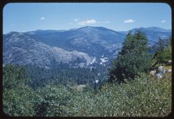
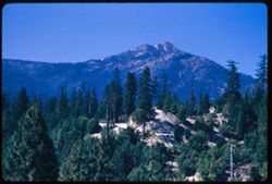
- Description:
- 100 f 6.3 tl
- Subject:
- Trees, Meadows, Mountains, Buttes, and Sutter Buttes (Calif.)
- Series:
- 11-57
- Creator:
- Cushman, Charles W., 1896-1972
- Date Created:
- 1957-07-22
- Genre:
- Landscape photographs
- Frame Number:
- 2
- Abstract:
- Sutter Buttes Hazy
- Call Number:
- P09411
- Country:
- United States
- State/Province:
- California
- Alternate Identifier:
- 1157.2
- Persistent URL:
- http://purl.dlib.indiana.edu/iudl/archives/cushman/P09411
- Holding Location:
- Bloomington - University Archives
Wells Library E460
1320 E 10th St.
Bloomington, IN 47405
Contact at archives@indiana.edu, 812-855-1127
-
- Description:
- 100 f 6.3 tl
- Subject:
- Shasta Lake (Calif.), Trees, Coastlines, Mountains, Lakes & ponds, and Clouds
- Series:
- 11-56
- Creator:
- Cushman, Charles W., 1896-1972
- Date Created:
- 1956-07-14
- Genre:
- Landscape photographs
- Frame Number:
- 2
- County:
- Shasta
- Abstract:
- Shasta Lake near O'Brien
- Call Number:
- P08900
- City:
- O'Brien
- Country:
- United States
- State/Province:
- California
- Alternate Identifier:
- 1156.2
- Persistent URL:
- http://purl.dlib.indiana.edu/iudl/archives/cushman/P08900
- Holding Location:
- Bloomington - University Archives
Wells Library E460
1320 E 10th St.
Bloomington, IN 47405
Contact at archives@indiana.edu, 812-855-1127
-
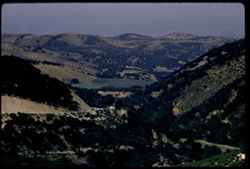
- Description:
- 100 f 8 TL
- Subject:
- Jolon Valley (Calif.), Roads, Jolon Grade, Trees, Mountains, and Hills
- Series:
- 6-56
- Creator:
- Cushman, Charles W., 1896-1972
- Date Created:
- 1956-04-21
- Genre:
- Landscape photographs
- Frame Number:
- 2
- County:
- Monterey
- Abstract:
- View eastward & down from Jolon grade
- Call Number:
- P08712
- Country:
- United States
- State/Province:
- California
- Alternate Identifier:
- 656.2
- Persistent URL:
- http://purl.dlib.indiana.edu/iudl/archives/cushman/P08712
- Holding Location:
- Bloomington - University Archives
Wells Library E460
1320 E 10th St.
Bloomington, IN 47405
Contact at archives@indiana.edu, 812-855-1127
-
- Description:
- 100 f 6.3 tl
- Subject:
- Hills, Mountains, Tamalpais, Mount (Calif.), and Trees
- Series:
- 2-56
- Creator:
- Cushman, Charles W., 1896-1972
- Date Created:
- 1956-03-14
- Genre:
- Landscape photographs
- Frame Number:
- 2
- County:
- Marin
- Abstract:
- From road on West shoulder of Mt. Tamalpais: Folded hills to north
- Call Number:
- P08568
- Country:
- United States
- State/Province:
- California
- Alternate Identifier:
- 256.2
- Persistent URL:
- http://purl.dlib.indiana.edu/iudl/archives/cushman/P08568
- Holding Location:
- Bloomington - University Archives
Wells Library E460
1320 E 10th St.
Bloomington, IN 47405
Contact at archives@indiana.edu, 812-855-1127
-
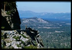
- Description:
- 100 f 6.3 TL
- Subject:
- Rocks, Echo Summit (El Dorado County, Calif.), Trees, Mountains, Tahoe, Lake (Calif. and Nev.), and Lakes & ponds
- Series:
- 25-55
- Creator:
- Cushman, Charles W., 1896-1972
- Date Created:
- 1955-09-24
- Genre:
- Landscape photographs
- Frame Number:
- 2
- Street Address:
- United States Highway 50
- County:
- Placer
- Abstract:
- North from just below (NE) of Echo Summit toward L. Tahoe
- Call Number:
- P08350
- Country:
- United States
- State/Province:
- California
- Physical Description:
- Image was originally mounted in a glass enclosure. Before digitization, the image was removed and placed in a Wess Plastic, Inc. brand, 2" x 2", pl...
- Alternate Identifier:
- 2555.2
- Persistent URL:
- http://purl.dlib.indiana.edu/iudl/archives/cushman/P08350
- Holding Location:
- Bloomington - University Archives
Wells Library E460
1320 E 10th St.
Bloomington, IN 47405
Contact at archives@indiana.edu, 812-855-1127
-
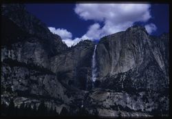
- Description:
- 100 f 8 50mm lens
- Subject:
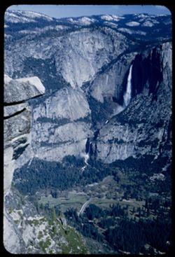
- Cliffs, Yosemite Falls (Calif.), Yosemite National Park (Calif.), Waterfalls, Trees, Mountains, National parks & reserves, and Clouds
- Series:
- 22-55
- Creator:
- Cushman, Charles W., 1896-1972
- Date Created:
- 1955-07-09
- Genre:
- Landscape photographs
- Frame Number:
- 2
- County:
- Mariposa
- Abstract:
- 0 Yosemite Fall
- Call Number:
- P08255
- Country:
- United States
- State/Province:
- California
- Physical Description:
- Image was originally mounted in a glass enclosure. Before digitization, the image was removed and placed in a Wess Plastic, Inc. brand, 2" x 2", pl...
- Alternate Identifier:
- 2255.2
- Persistent URL:
- http://purl.dlib.indiana.edu/iudl/archives/cushman/P08255
- Holding Location:
- Bloomington - University Archives
Wells Library E460
1320 E 10th St.
Bloomington, IN 47405
Contact at archives@indiana.edu, 812-855-1127
-
- Description:
- 100 f 5.6 tl
- Subject:
- Yosemite Valley (Calif.), Valleys, Roads, Yosemite National Park (Calif.), Trees, Mountains, Glacier Point (Calif.), National parks & reserves, and Rock ...
- Series:
- 21-55
- Creator:
- Cushman, Charles W., 1896-1972
- Date Created:
- 1955-07-08
- Genre:
- Views
- Frame Number:
- 2
- County:
- Mariposa
- Abstract:
- Julling rock
- Call Number:
- P08221
- Country:
- United States
- State/Province:
- California
- Alternate Identifier:
- 2155.2
- Persistent URL:
- http://purl.dlib.indiana.edu/iudl/archives/cushman/P08221
- Holding Location:
- Bloomington - University Archives
Wells Library E460
1320 E 10th St.
Bloomington, IN 47405
Contact at archives@indiana.edu, 812-855-1127
-
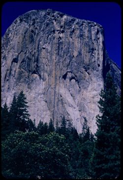
- Description:
- 100 f 8 sl
- Subject:
- Mountains, Trees, Yosemite Valley (Calif.), and El Capitan (Calif.)
- Series:
- 20-55
- Creator:
- Cushman, Charles W., 1896-1972
- Date Created:
- 1955-07-07
- Genre:
- Landscape photographs
- Frame Number:
- 2
- County:
- Mariposa
- Abstract:
- El Capitan from west
- Call Number:
- P08188
- Country:
- United States
- State/Province:
- California
- Alternate Identifier:
- 2055.2
- Persistent URL:
- http://purl.dlib.indiana.edu/iudl/archives/cushman/P08188
- Holding Location:
- Bloomington - University Archives
Wells Library E460
1320 E 10th St.
Bloomington, IN 47405
Contact at archives@indiana.edu, 812-855-1127
-
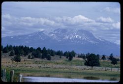
- Description:
- 100 f 6.3 tl
- Subject:
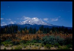
- Hills, Bodies of water, Mountains, Shrubs, Snow, Trees, Clouds, Fences, Shasta, Mount (Calif. : Mountain), and Grasses
- Series:
- 18-55
- Creator:
- Cushman, Charles W., 1896-1972
- Date Created:
- 1955-06-17
- Genre:
- Landscape photographs
- Frame Number:
- 2
- County:
- Siskiyou
- Abstract:
- Mt. Shasta at 2:35 from road east of Grenada
- Call Number:
- P08119
- City:
- Grenada
- Country:
- United States
- State/Province:
- California
- Alternate Identifier:
- 1855.2
- Persistent URL:
- http://purl.dlib.indiana.edu/iudl/archives/cushman/P08119
- Holding Location:
- Bloomington - University Archives
Wells Library E460
1320 E 10th St.
Bloomington, IN 47405
Contact at archives@indiana.edu, 812-855-1127
-
- Description:
- 100 f 5.6 tl
- Subject:
- Bully Choop Mountain (Calif.), Trees, Mountains, and Shrubs
- Series:
- 17-55
- Creator:
- Cushman, Charles W., 1896-1972
- Date Created:
- 1955-06-16
- Genre:
- Landscape photographs
- Frame Number:
- 2
- Street Address:
- United States Highway 299
- County:
- Trinity
- Abstract:
- Bully Choop Mtn from 299 23 mi. e of Weaverville 65563
- Call Number:
- P08084
- City:
- Weaverville
- Country:
- United States
- State/Province:
- California
- Alternate Identifier:
- 1755.2
- Persistent URL:
- http://purl.dlib.indiana.edu/iudl/archives/cushman/P08084
- Holding Location:
- Bloomington - University Archives
Wells Library E460
1320 E 10th St.
Bloomington, IN 47405
Contact at archives@indiana.edu, 812-855-1127
-
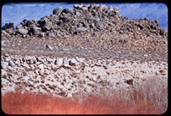
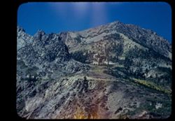
- Description:
- 100 f 5.6 tl
- Subject:
- Hills, Mounds (Landforms), Mountains, Shrubs, Trees, Alabama Hills (Calif.), Boulders, and Rocks
- Series:
- 4-55
- Creator:
- Cushman, Charles W., 1896-1972
- Date Created:
- 1955-02-28
- Genre:
- Landscape photographs
- Frame Number:
- 2
- County:
- Inyo
- Abstract:
- Mound of boulders = Alabama Hills
- Call Number:
- P07631
- City:
- Lone Pine
- Country:
- United States
- State/Province:
- California
- Alternate Identifier:
- 455.2
- Persistent URL:
- http://purl.dlib.indiana.edu/iudl/archives/cushman/P07631
- Holding Location:
- Bloomington - University Archives
Wells Library E460
1320 E 10th St.
Bloomington, IN 47405
Contact at archives@indiana.edu, 812-855-1127
-
- Description:
- 100 f 5.6 tl
- Subject:
- Roads, Trees, Mountains, Clouds, Pacheco Pass (Calif.), and Hills
- Series:
- 2-55
- Creator:
- Cushman, Charles W., 1896-1972
- Date Created:
- 1955-02-25
- Genre:
- Landscape photographs
- Frame Number:
- 2
- County:
- Santa Clara
- Abstract:
- N & E from same
- Call Number:
- P07560
- Country:
- United States
- State/Province:
- California
- Alternate Identifier:
- 255.2
- Persistent URL:
- http://purl.dlib.indiana.edu/iudl/archives/cushman/P07560
- Holding Location:
- Bloomington - University Archives
Wells Library E460
1320 E 10th St.
Bloomington, IN 47405
Contact at archives@indiana.edu, 812-855-1127
-
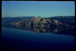
- Description:
- 50 f 8
- Subject:
- Bays (Bodies of water), Trees, Mountains, Lakes & ponds, Reflections, Clear Lake (Lake County, Calif.), and Soda Bay (Calif.)
- Series:
- 17-54
- Creator:
- Cushman, Charles W., 1896-1972
- Date Created:
- 1954-11-04
- Genre:
- Landscape photographs
- Frame Number:
- 2
- County:
- Lake
- Abstract:
- Across Soda Bay in late aft. - Reflection
- Call Number:
- P07523
- Country:
- United States
- State/Province:
- California
- Physical Description:
- Anscochrome film.
- Alternate Identifier:
- 1754.2
- Persistent URL:
- http://purl.dlib.indiana.edu/iudl/archives/cushman/P07523
- Holding Location:
- Bloomington - University Archives
Wells Library E460
1320 E 10th St.
Bloomington, IN 47405
Contact at archives@indiana.edu, 812-855-1127
-
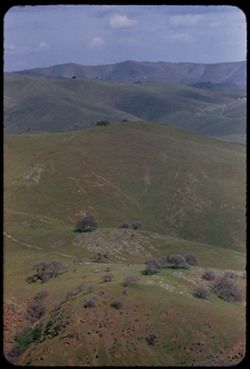
- Description:
- 50 f 9
- Subject:
- Valleys, Trees, Mountains, Shrubs, Lakes & ponds, and Tamalpais, Mount (Calif.)
- Series:
- 16-54
- Creator:
- Cushman, Charles W., 1896-1972
- Date Created:
- 1954-10-23
- Genre:
- Landscape photographs
- Frame Number:
- 2
- County:
- Marin
- Abstract:
- View NNW from top of Tamalpais.
- Call Number:
- P07501
- Country:
- United States
- State/Province:
- California
- Physical Description:
- Anscochrome film.
- Alternate Identifier:
- 1654.2
- Persistent URL:
- http://purl.dlib.indiana.edu/iudl/archives/cushman/P07501
- Holding Location:
- Bloomington - University Archives
Wells Library E460
1320 E 10th St.
Bloomington, IN 47405
Contact at archives@indiana.edu, 812-855-1127
-
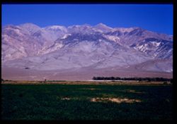
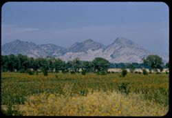
- Description:
- 50 f 11
- Subject:
- Alfalfa, White Mountains (Calif. and Nev.), Farms, Trees, Meadows, Croplands, Shrubs, and Mountains
- Series:
- 12-54
- Creator:
- Cushman, Charles W., 1896-1972
- Date Created:
- 1954-09-17
- Genre:
- Landscape photographs
- Frame Number:
- 2
- Street Address:
- United States Highway 6, United States Highway 395, and California State Highway 14
- County:
- Inyo
- Abstract:
- From 2 miles further north, Colorful mountain wall east side Owen Valley from US 6 about 20 mi. north of Bishop, across alphalfa field.
- Call Number:
- P07393
- City:
- Bishop
- Country:
- United States
- State/Province:
- California
- Physical Description:
- Image was originally mounted in a glass enclosure. Before digitization, the image was removed and placed in a Wess Plastic, Inc. brand, 2" x 2", pl...
- Alternate Identifier:
- 1254.2
- Persistent URL:
- http://purl.dlib.indiana.edu/iudl/archives/cushman/P07393
- Holding Location:
- Bloomington - University Archives
Wells Library E460
1320 E 10th St.
Bloomington, IN 47405
Contact at archives@indiana.edu, 812-855-1127
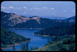
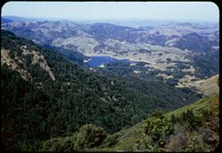
-
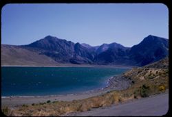
- Description:
- 50 f 8
- Subject:
- Lakes & ponds, Bodies of water, Mountains, Shrubs, Trees, Coastlines, and Grant Lake (Calif.)
- Series:
- 11-54
- Creator:
- Cushman, Charles W., 1896-1972
- Date Created:
- 1954-09-16
- Genre:
- Landscape photographs
- Frame Number:
- 2
- County:
- Mono
- Abstract:
- Grant Lake.
- Call Number:
- P07371
- Country:
- United States
- State/Province:
- California
- Alternate Identifier:
- 1154.2
- Persistent URL:
- http://purl.dlib.indiana.edu/iudl/archives/cushman/P07371
- Holding Location:
- Bloomington - University Archives
Wells Library E460
1320 E 10th St.
Bloomington, IN 47405
Contact at archives@indiana.edu, 812-855-1127
-
- Description:
- 50 f 9
- Subject:
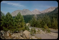
- Rocks, Yosemite National Park (Calif.), Trees, Lee Vining Creek (Calif.), Tioga Pass (Calif.), Mountains, and Shrubs
- Series:
- 10-54
- Creator:
- Cushman, Charles W., 1896-1972
- Date Created:
- 1954-09-16
- Genre:
- Landscape photographs
- Frame Number:
- 2
- Street Address:
- California State Highway 140
- County:
- Mono
- Abstract:
- Granite + red rock.
- Call Number:
- P07349
- Country:
- United States
- State/Province:
- California
- Physical Description:
- Anscochrome film, masked.
- Alternate Identifier:
- 1054.2
- Persistent URL:
- http://purl.dlib.indiana.edu/iudl/archives/cushman/P07349
- Holding Location:
- Bloomington - University Archives
Wells Library E460
1320 E 10th St.
Bloomington, IN 47405
Contact at archives@indiana.edu, 812-855-1127
-
- Description:
- 50 f 8
- Subject:
- Rocks, Canyons, Trees, Volcanoes, Buttes, Dardanelles Butte (Calif.), Stanislaus River (Calif.), Mountains, Shrubs, Lava flows, and Dardanelles Cone (Calif.)
- Series:
- 9-54
- Creator:
- Cushman, Charles W., 1896-1972
- Date Created:
- 1954-09-15
- Genre:
- Landscape photographs
- Frame Number:
- 2
- Street Address:
- California State Highway 1 and California State Highway 108
- County:
- Tuolumne
- Abstract:
- Dardanelles Cone. Looking north across canyon from Hwy 108 about 8 or 9 miles w. of Dardanelle.
- Call Number:
- P07313
- City:
- Dardanelle
- Country:
- United States
- State/Province:
- California
- Alternate Identifier:
- 954.2
- Persistent URL:
- http://purl.dlib.indiana.edu/iudl/archives/cushman/P07313
- Holding Location:
- Bloomington - University Archives
Wells Library E460
1320 E 10th St.
Bloomington, IN 47405
Contact at archives@indiana.edu, 812-855-1127
-
- Description:
- 50 f 9
- Subject:
- Snow, Cascade Range, Grasses, Trees, Volcanoes, Lassen Volcanic National Park (Calif.), Mountains, Shrubs, Mount Shasta (Calif. : Mountain), and Stratovolcanoes
- Series:
- 7-54
- Creator:
- Cushman, Charles W., 1896-1972
- Date Created:
- 1954-08-21
- Genre:
- Landscape photographs
- Frame Number:
- 2
- Street Address:
- California State Highway 89
- County:
- Siskiyou
- Abstract:
- Mt Shasta from Cal. 89 on SE.
- Call Number:
- P07258
- Country:
- United States
- State/Province:
- California
- Physical Description:
- Image was originally mounted in a glass enclosure. Before digitization, the image was removed and placed in a Wess Plastic, Inc. brand, 2" x 2", pl...
- Alternate Identifier:
- 754.2
- Persistent URL:
- http://purl.dlib.indiana.edu/iudl/archives/cushman/P07258
- Holding Location:
- Bloomington - University Archives
Wells Library E460
1320 E 10th St.
Bloomington, IN 47405
Contact at archives@indiana.edu, 812-855-1127
-
- Description:
- 50 f 8
- Subject:
- Cascade Range, Volcanic rock, Trees, Shadows, Volcanic domes, Lassen Volcanic National Park (Calif.), Lava domes, Shrubs, Bumpass Mountain (Calif.), Volcanoe...
- Series:
- 6-54
- Creator:
- Cushman, Charles W., 1896-1972
- Date Created:
- 1954-08-19
- Genre:
- Landscape photographs
- Frame Number:
- 2
- County:
- Shasta
- Abstract:
- Lava excrescence of Bumpass Mt
- Call Number:
- P07221
- Country:
- United States
- State/Province:
- California
- Alternate Identifier:
- 654.2
- Persistent URL:
- http://purl.dlib.indiana.edu/iudl/archives/cushman/P07221
- Holding Location:
- Bloomington - University Archives
Wells Library E460
1320 E 10th St.
Bloomington, IN 47405
Contact at archives@indiana.edu, 812-855-1127
-
- Description:
- 50 f 9
- Subject:
- Rocks, Chaos Crags (Calif.), Roads, Volcanic rock, Trees, Pines, Volcanic domes, Lassen Volcanic National Park (Calif.), Lava domes, Shrubs, Lassen Peak (Cal...
- Series:
- 5-54
- Creator:
- Cushman, Charles W., 1896-1972
- Date Created:
- 1954-08-19
- Genre:
- Landscape photographs
- Frame Number:
- 2
- County:
- Shasta
- Abstract:
- Chaos Crags from SE
- Call Number:
- P07198
- Country:
- United States
- State/Province:
- California
- Physical Description:
- Anscochrome film.
- Alternate Identifier:
- 554.2
- Persistent URL:
- http://purl.dlib.indiana.edu/iudl/archives/cushman/P07198
- Holding Location:
- Bloomington - University Archives
Wells Library E460
1320 E 10th St.
Bloomington, IN 47405
Contact at archives@indiana.edu, 812-855-1127
-
- Description:
- 25 f 11
- Subject:
- Roads, Yosemite Falls (Calif.), Yosemite National Park (Calif.), Waterfalls, Trees, Mountains, Shrubs, National parks & reserves, and Glacier Point (Calif.)
- Series:
- 5-53
- Creator:
- Cushman, Charles W., 1896-1972
- Date Created:
- 1953-05-13
- Genre:
- Landscape photographs
- Frame Number:
- 2
- County:
- Mariposa
- Abstract:
- Yosemite Falls from Glacier Pt. overhang.
- Call Number:
- P06652
- Country:
- United States
- State/Province:
- California
- Alternate Identifier:
- 553.2
- Persistent URL:
- http://purl.dlib.indiana.edu/iudl/archives/cushman/P06652
- Holding Location:
- Bloomington - University Archives
Wells Library E460
1320 E 10th St.
Bloomington, IN 47405
Contact at archives@indiana.edu, 812-855-1127
-
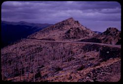
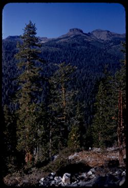
- Description:
- 50 f 8
- Subject:
- Rocks, Rocky Mountains, Forest fires, Roads, Trees, Tree limbs, Mountains, National parks & reserves, Forests, Rocky Mountain National Park (Colo.), and ...
- Series:
- 25-52
- Creator:
- Cushman, Charles W., 1896-1972
- Date Created:
- 1952-11-02
- Genre:
- Landscape photographs
- Frame Number:
- 2
- Abstract:
- Desolation - this forest burned many years ago.
- Call Number:
- P06371
- Country:
- United States
- State/Province:
- Colorado
- Alternate Identifier:
- 2552.2
- Persistent URL:
- http://purl.dlib.indiana.edu/iudl/archives/cushman/P06371
- Holding Location:
- Bloomington - University Archives
Wells Library E460
1320 E 10th St.
Bloomington, IN 47405
Contact at archives@indiana.edu, 812-855-1127
-
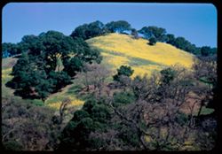
- Description:
- 25 f 9
- Subject:
- Wildflowers, Trees, Flowers, Mountains, Hills, and Mustard (Plant)
- Series:
- 10-52
- Creator:
- Cushman, Charles W., 1896-1972
- Date Created:
- 1952-02-09
- Genre:
- Landscape photographs
- Frame Number:
- 2
- Street Address:
- California State Highway 24
- County:
- Contra Costa
- Abstract:
- Mustard covered mtn. side nr. Lafayette on Cal 24
- Call Number:
- P05838
- City:
- Lafayette
- Country:
- United States
- State/Province:
- California
- Alternate Identifier:
- 1052.2
- Persistent URL:
- http://purl.dlib.indiana.edu/iudl/archives/cushman/P05838
- Holding Location:
- Bloomington - University Archives
Wells Library E460
1320 E 10th St.
Bloomington, IN 47405
Contact at archives@indiana.edu, 812-855-1127
-
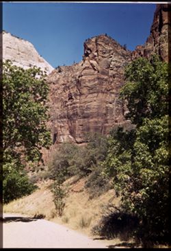
- Subject:
- Weeping Rock (Utah), Mountains, Trees, Temple of Sinawava (Utah), Zion Canyon (Utah), Zion National Park (Utah), Cliffs, Roads, National parks & reserves...
- Series:
- 11-40
- Creator:
- Cushman, Charles W., 1896-1972
- Date Created:
- 1940-07-11/1940-07-12
- Genre:
- Landscape photographs
- Frame Number:
- 2
- County:
- Washington
- Abstract:
- Bed of mountain stream below Weeping Rock.
- Call Number:
- P01962
- Country:
- United States
- State/Province:
- Utah
- Physical Description:
- Image was originally mounted in a glass enclosure. Before digitization, the image was removed and placed in a Wess Plastic, Inc. brand, 2" x 2", pl...
- Alternate Identifier:
- 1140.2
- Persistent URL:
- http://purl.dlib.indiana.edu/iudl/archives/cushman/P01962
- Holding Location:
- Bloomington - University Archives
Wells Library E460
1320 E 10th St.
Bloomington, IN 47405
Contact at archives@indiana.edu, 812-855-1127
-
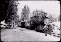
- Subject:
- Automobiles, Trees, Walkways, Mountains, Facilities, Virginia and Truckee Railroad, Utility poles, Railroad employees, and Railroads
- Series:
- 23-40
- Creator:
- Cushman, Charles W., 1896-1972
- Date Created:
- 1940-07-07
- Frame Number:
- 2
- County:
- Carson City
- Abstract:
- 40-J-2=at Carson City, Nev.-Virginia & Truckee RR
- Call Number:
- P01951
- City:
- Carson City
- Country:
- United States
- State/Province:
- Nevada
- Physical Description:
- black & white .
- Alternate Identifier:
- 2340.2
- Persistent URL:
- http://purl.dlib.indiana.edu/iudl/archives/cushman/P01951
- Holding Location:
- Bloomington - University Archives
Wells Library E460
1320 E 10th St.
Bloomington, IN 47405
Contact at archives@indiana.edu, 812-855-1127
-
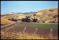
- Subject:
- Farmhouses, Roads, Trees, Mountains, Fences, Shrubs, Agricultural facilities, and Croplands
- Series:
- 7-40
- Creator:
- Cushman, Charles W., 1896-1972
- Date Created:
- 1940-06-20
- Genre:
- Landscape photographs
- Frame Number:
- 2
- Street Address:
- Atascadero Road
- County:
- San Luis Obispo
- Abstract:
- Fields+ mtns. San Luis county
- Call Number:
- P01858
- City:
- Morro Bay
- Country:
- United States
- State/Province:
- California
- Physical Description:
- Image was originally mounted in a glass enclosure. Before digitization, the image was removed and placed in a Wess Plastic, Inc. brand, 2" x 2", pl...
- Alternate Identifier:
- 740.2
- Persistent URL:
- http://purl.dlib.indiana.edu/iudl/archives/cushman/P01858
- Holding Location:
- Bloomington - University Archives
Wells Library E460
1320 E 10th St.
Bloomington, IN 47405
Contact at archives@indiana.edu, 812-855-1127
-
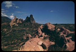
- Subject:
- Hills, Automobiles, Roads, Mountains, Shrubs, Trees, Buildings, Signs (Notices), Wildflowers, Garden of the Gods (Colorado Springs, Colo.), and Dwellings
- Series:
- 14-40
- Creator:
- Cushman, Charles W., 1896-1972
- Date Created:
- 1940-07-19
- Genre:
- Cityscape photographs
- Frame Number:
- 2
- County:
- El Paso
- Abstract:
- In the Garden of the Gods- near Colo. Spgs.
- Call Number:
- P01820
- City:
- Colorado Springs
- Country:
- United States
- State/Province:
- Colorado
- Alternate Identifier:
- 1440.2
- Persistent URL:
- http://purl.dlib.indiana.edu/iudl/archives/cushman/P01820
- Holding Location:
- Bloomington - University Archives
Wells Library E460
1320 E 10th St.
Bloomington, IN 47405
Contact at archives@indiana.edu, 812-855-1127
-
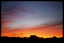
- Subject:
- Trees, Mountains, and Sunrises & sunsets
- Series:
- 3-40
- Creator:
- Cushman, Charles W., 1896-1972
- Date Created:
- 1940-03-01
- Genre:
- Landscape photographs
- Frame Number:
- 2
- County:
- Pima
- Abstract:
- A sunset seen from The Sage and Sand.
- Call Number:
- P01773
- City:
- Tucson
- Country:
- United States
- State/Province:
- Arizona
- Physical Description:
- Image was originally mounted in a glass enclosure. Before digitization, the image was removed and placed in a Wess Plastic, Inc. brand, 2" x 2", pl...
- Alternate Identifier:
- 340.2
- Persistent URL:
- http://purl.dlib.indiana.edu/iudl/archives/cushman/P01773
- Holding Location:
- Bloomington - University Archives
Wells Library E460
1320 E 10th St.
Bloomington, IN 47405
Contact at archives@indiana.edu, 812-855-1127
-
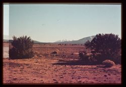
- Subject:
- Snow, Trees, Mountains, Shrubs, and Grand Canyon (Ariz.)
- Series:
- 10-39
- Creator:
- Cushman, Charles W., 1896-1972
- Date Created:
- 1939-12-01
- Genre:
- Landscape photographs
- Frame Number:
- 2
- Street Address:
- Grand Canyon Highway
- Abstract:
- T-2: Arizona's Highest Pk., from Grand Canyon Hwy.
- Call Number:
- P01718
- Country:
- United States
- State/Province:
- Arizona
- Physical Description:
- some dye fading. Image was originally mounted in a glass enclosure. Before digitization, the image was removed and placed in a Wess Plastic, Inc. brand, 2&qu...
- Alternate Identifier:
- 1039.2
- Persistent URL:
- http://purl.dlib.indiana.edu/iudl/archives/cushman/P01718
- Holding Location:
- Bloomington - University Archives
Wells Library E460
1320 E 10th St.
Bloomington, IN 47405
Contact at archives@indiana.edu, 812-855-1127
-
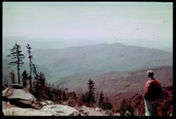
- Subject:
- Men, Fog, Mountains, Shrubs, Trees, Rocks, Great Smoky Mountains (N.C. and Tenn.), and Farney Ridge
- Series:
- 5-39
- Creator:
- Cushman, Charles W., 1896-1972
- Date Created:
- 1939-05-01
- Genre:
- Landscape photographs
- Frame Number:
- 2
- Persons Pictured:
- Cushman, Charles W. (Charles Weever), 1896-1972
- Abstract:
- N-2= View west from Farney Ridge, Great Smoky Mtns
- Call Number:
- P01629
- Country:
- United States
- State/Province:
- Tennessee and North Carolina
- Physical Description:
- Color corrected: magenta cast [fading of yellow dye]. Image was originally mounted in a glass enclosure. Before digitization, the image was removed and place...
- Alternate Identifier:
- 539.2
- Persistent URL:
- http://purl.dlib.indiana.edu/iudl/archives/cushman/P01629
- Holding Location:
- Bloomington - University Archives
Wells Library E460
1320 E 10th St.
Bloomington, IN 47405
Contact at archives@indiana.edu, 812-855-1127
-
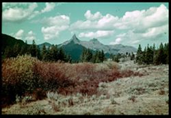
- Subject:
- Trees, Red Lodge (Mont.), Mountains, Index Peak (Wyo.), Clouds, Yellowstone National Park, Pilot Peak (Wyo.), and Shrubs
- Series:
- 7-38
- Creator:
- Cushman, Charles W., 1896-1972
- Date Created:
- 1938-10-01
- Genre:
- Landscape photographs
- Frame Number:
- 2
- Street Address:
- Cooke-Red Lodge Highway
- County:
- Park and Carbon
- Abstract:
- G-2= Index and Pilot Pks. from distance
- Call Number:
- P01512
- City:
- Cooke City
- Country:
- United States
- State/Province:
- Wyoming and Montana
- Physical Description:
- Color corrected: magenta cast [fading of yellow dye]. Image was originally mounted in a glass enclosure. Before digitization, the image was removed and place...
- Alternate Identifier:
- 738.2
- Persistent URL:
- http://purl.dlib.indiana.edu/iudl/archives/cushman/P01512
- Holding Location:
- Bloomington - University Archives
Wells Library E460
1320 E 10th St.
Bloomington, IN 47405
Contact at archives@indiana.edu, 812-855-1127