
Search Constraints
You searched for:
Campus
IUB
Remove constraint Campus: IUB
Frame Number
22
Remove constraint Frame Number: 22
Subject
Mountains
Remove constraint Subject: Mountains
State/Province
California
Remove constraint State/Province: California
1 - 47 of 47
Search Results
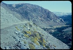
-
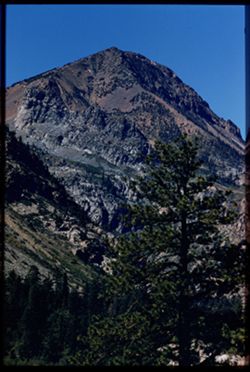
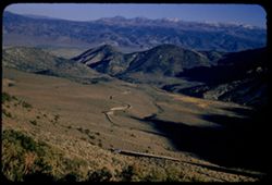
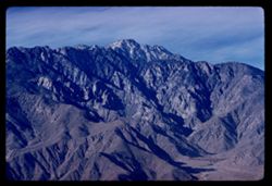
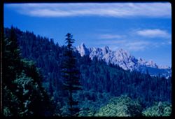
- Description:
- 100 f 9 tl tel lens
- Subject:
- Tioga Peak (Calif.), Mountains, Pines, and Rock formations
- Series:
- 27-55
- Creator:
- Cushman, Charles W., 1896-1972
- Date Created:
- 1955-09-26
- Genre:
- Landscape photographs
- Frame Number:
- 22
- County:
- Mono
- Abstract:
- Tioga Pk [P]
- Call Number:
- P08441
- Country:
- United States
- State/Province:
- California
- Physical Description:
- Image was originally mounted in a glass enclosure. Before digitization, the image was removed and placed in a Wess Plastic, Inc. brand, 2" x 2", pl...
- Alternate Identifier:
- 2755.22
- Persistent URL:
- http://purl.dlib.indiana.edu/iudl/archives/cushman/P08441
- Holding Location:
- Bloomington - University Archives
Wells Library E460
1320 E 10th St.
Bloomington, IN 47405
Contact at archives@indiana.edu, 812-855-1127
-
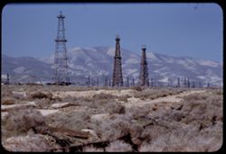
- Description:
- 100 f 5.6 tl
- Subject:
- Oil wells, Storage tanks, Hills, Mountains, Dirt roads, Shrubs, Oil well drilling rigs, and Facilities
- Series:
- 4-55
- Creator:
- Cushman, Charles W., 1896-1972
- Date Created:
- 1955-03-01
- Genre:
- Views
- Frame Number:
- 22
- County:
- Kern
- Abstract:
- 3 derricks with folded hills in background (Hazy)
- Call Number:
- P07649
- City:
- Taft
- Country:
- United States
- State/Province:
- California
- Alternate Identifier:
- 455.22
- Persistent URL:
- http://purl.dlib.indiana.edu/iudl/archives/cushman/P07649
- Holding Location:
- Bloomington - University Archives
Wells Library E460
1320 E 10th St.
Bloomington, IN 47405
Contact at archives@indiana.edu, 812-855-1127
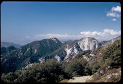
-
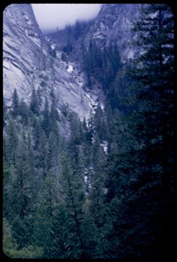
- Description:
- 25 f 3.5
- Subject:
- Illilouette Fall (Calif.), National parks & reserves, Valleys, Mountains, Yosemite National Park (Calif.), Waterfalls, Trees, and Vernal Fall trail (Calif.)
- Series:
- 6-53
- Creator:
- Cushman, Charles W., 1896-1972
- Date Created:
- 1953-05-15
- Genre:
- Landscape photographs
- Frame Number:
- 22
- County:
- Mariposa
- Abstract:
- Cascade of Illiloulette from VF trail.
- Call Number:
- P06710
- Country:
- United States
- State/Province:
- California
- Alternate Identifier:
- 653.22
- Persistent URL:
- http://purl.dlib.indiana.edu/iudl/archives/cushman/P06710
- Holding Location:
- Bloomington - University Archives
Wells Library E460
1320 E 10th St.
Bloomington, IN 47405
Contact at archives@indiana.edu, 812-855-1127
-
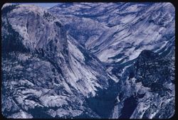
- Description:
- 100 f 8 tl
- Subject:
- National parks & reserves, Tenaya Canyon (Calif.), Half Dome (Calif.), Watkins, Mount (Calif.), Mountains, Yosemite National Park (Calif.), and Rock form...
- Series:
- 21-55
- Creator:
- Cushman, Charles W., 1896-1972
- Date Created:
- 1955-07-08
- Genre:
- Landscape photographs
- Frame Number:
- 22
- County:
- Mariposa
- Abstract:
- Tenaya canyon
- Call Number:
- P08239
- Country:
- United States
- State/Province:
- California
- Alternate Identifier:
- 2155.22
- Persistent URL:
- http://purl.dlib.indiana.edu/iudl/archives/cushman/P08239
- Holding Location:
- Bloomington - University Archives
Wells Library E460
1320 E 10th St.
Bloomington, IN 47405
Contact at archives@indiana.edu, 812-855-1127
-
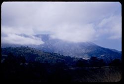
- Description:
- 50 f 6.3
- Subject:
- Hills, Mountains, Trees, Tehachapi Mountains (Calif.), Clouds, and Grasses
- Series:
- 16-53
- Creator:
- Cushman, Charles W., 1896-1972
- Date Created:
- 1953-11-23
- Genre:
- Landscape photographs
- Frame Number:
- 22
- County:
- Kern
- Abstract:
- Clouds through Tehachapi Mtns
- Call Number:
- P07094
- City:
- Tehachapi and Bakersfield
- Country:
- United States
- State/Province:
- California
- Alternate Identifier:
- 1653.22
- Persistent URL:
- http://purl.dlib.indiana.edu/iudl/archives/cushman/P07094
- Holding Location:
- Bloomington - University Archives
Wells Library E460
1320 E 10th St.
Bloomington, IN 47405
Contact at archives@indiana.edu, 812-855-1127
-
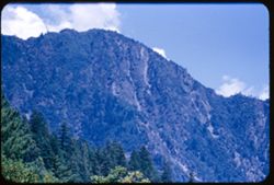
- Description:
- 100 f 5.6 tl
- Subject:
- Mountains, Trees, Trinity River (Calif.), and Clouds
- Series:
- 16-55
- Creator:
- Cushman, Charles W., 1896-1972
- Date Created:
- 1955-06-15
- Genre:
- Landscape photographs
- Frame Number:
- 22
- County:
- Trinity
- Abstract:
- from same spot
- Call Number:
- P08066
- Country:
- United States
- State/Province:
- California
- Alternate Identifier:
- 1655.22
- Persistent URL:
- http://purl.dlib.indiana.edu/iudl/archives/cushman/P08066
- Holding Location:
- Bloomington - University Archives
Wells Library E460
1320 E 10th St.
Bloomington, IN 47405
Contact at archives@indiana.edu, 812-855-1127
-
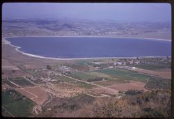
- Description:
- 100 f 6.3 tl
- Subject:
- Lakes & ponds, Cities & towns, Hills, Roads, Mountains, Shrubs, Trees, Buildings, Plants, Houses, and Lake Elsinore (Calif.)
- Series:
- 11-59
- Creator:
- Cushman, Charles W., 1896-1972
- Date Created:
- 1959-03-25
- Genre:
- Aerial photographs
- Frame Number:
- 22
- County:
- Riverside
- Abstract:
- L. Elsinore from above
- Call Number:
- P10747
- City:
- Elsinore
- Country:
- United States
- State/Province:
- California
- Alternate Identifier:
- 1159.22
- Persistent URL:
- http://purl.dlib.indiana.edu/iudl/archives/cushman/P10747
- Holding Location:
- Bloomington - University Archives
Wells Library E460
1320 E 10th St.
Bloomington, IN 47405
Contact at archives@indiana.edu, 812-855-1127
-
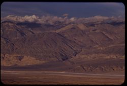
- Description:
- 100 f 6.3 tl
- Subject:
- Valleys, Mountains, Snow, Clouds, and Panamint Range (Calif.)
- Series:
- 2-55
- Creator:
- Cushman, Charles W., 1896-1972
- Date Created:
- 1955-02-26
- Genre:
- Landscape photographs
- Frame Number:
- 22
- Street Address:
- Trona Road
- County:
- Inyo
- Abstract:
- Panamint Mtns east of rd north from Trona
- Call Number:
- P07580
- Country:
- United States
- State/Province:
- California
- Alternate Identifier:
- 255.22
- Persistent URL:
- http://purl.dlib.indiana.edu/iudl/archives/cushman/P07580
- Holding Location:
- Bloomington - University Archives
Wells Library E460
1320 E 10th St.
Bloomington, IN 47405
Contact at archives@indiana.edu, 812-855-1127
-
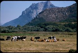
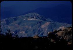
- Description:
- 100 f 5.6 tl
- Subject:
- Meadows, Mountains, Grazing, Hollister Peak (Calif.), and Cattle
- Series:
- 14-57
- Creator:
- Cushman, Charles W., 1896-1972
- Date Created:
- 1957-09-19
- Genre:
- Identification photographs and Landscape photographs
- Frame Number:
- 22
- County:
- San Luis Obispo
- Abstract:
- Hollister Pk (big rock comb) from NW
- Call Number:
- P09521
- Country:
- United States
- State/Province:
- California
- Alternate Identifier:
- 1457.22
- Persistent URL:
- http://purl.dlib.indiana.edu/iudl/archives/cushman/P09521
- Holding Location:
- Bloomington - University Archives
Wells Library E460
1320 E 10th St.
Bloomington, IN 47405
Contact at archives@indiana.edu, 812-855-1127
-
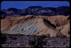
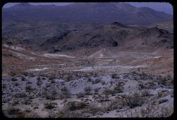
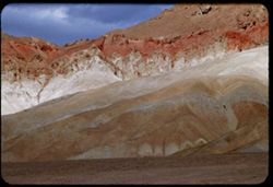
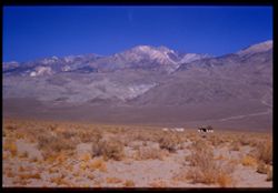
- Description:
- 100 f 8 tl
- Subject:
- Rocks, Valleys, Mountains, Shrubs, Death Valley (Calif. and Nev.), Black Mountains (Inyo County, Calif.), and Hills
- Series:
- 8-55
- Creator:
- Cushman, Charles W., 1896-1972
- Date Created:
- 1955-03-22
- Genre:
- Landscape photographs
- Frame Number:
- 22
- Street Address:
- Dante's View Road
- County:
- Inyo
- Abstract:
- colored rock in valley from closer (along Dante's V. rd.
- Call Number:
- P07780
- Country:
- United States
- State/Province:
- California
- Alternate Identifier:
- 855.22
- Persistent URL:
- http://purl.dlib.indiana.edu/iudl/archives/cushman/P07780
- Holding Location:
- Bloomington - University Archives
Wells Library E460
1320 E 10th St.
Bloomington, IN 47405
Contact at archives@indiana.edu, 812-855-1127
-
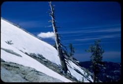
- Description:
- 50 f 5.6 Pola
- Subject:
- Snow, Yosemite National Park (Calif.), Trees, Mountains, National parks & reserves, Sentinel Dome (Calif.), and Clouds
- Series:
- 5-53
- Creator:
- Cushman, Charles W., 1896-1972
- Date Created:
- 1953-05-13
- Genre:
- Landscape photographs
- Frame Number:
- 22
- County:
- Mariposa
- Abstract:
- West from shoulder of Sent Dome.
- Call Number:
- P06672
- Country:
- United States
- State/Province:
- California
- Alternate Identifier:
- 553.22
- Persistent URL:
- http://purl.dlib.indiana.edu/iudl/archives/cushman/P06672
- Holding Location:
- Bloomington - University Archives
Wells Library E460
1320 E 10th St.
Bloomington, IN 47405
Contact at archives@indiana.edu, 812-855-1127
-
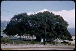
- Description:
- 25 f 8
- Subject:
- Fig trees, Electric lines, Automobiles, Trees, Streets, Mountains, Lawns, Ficus macrophylla, Traffic signs & signals, Utility poles, Rocks, Moreton Bay F...
- Series:
- 8-52
- Creator:
- Cushman, Charles W., 1896-1972
- Date Created:
- 1952-03-01
- Genre:
- Identification photographs
- Frame Number:
- 22
- County:
- Santa Barbara
- Abstract:
- Moreton Bay Fig (Ficus Macrophylla-Australia-largest in U.S.-branch spread 135 ft. 1942-Planted in 1877
- Call Number:
- P05781
- City:
- Santa Barbara
- Country:
- United States
- State/Province:
- California
- Alternate Identifier:
- 852.22
- Persistent URL:
- http://purl.dlib.indiana.edu/iudl/archives/cushman/P05781
- Holding Location:
- Bloomington - University Archives
Wells Library E460
1320 E 10th St.
Bloomington, IN 47405
Contact at archives@indiana.edu, 812-855-1127
-
- Description:
- 100 f 5.6 SL
- Subject:
- Valleys, Roads, Shadows, Mountains, Antelope Valley (Calif.), Land, Monitor Pass (Calif.), Sweetwater Mountains (Calif. and Nev.), and Plants
- Series:
- 25-55
- Creator:
- Cushman, Charles W., 1896-1972
- Date Created:
- 1955-09-24
- Genre:
- Landscape photographs
- Frame Number:
- 22
- Street Address:
- California State Highway 89
- County:
- Mono and Alpine
- Abstract:
- Across to high Sweetwater mtns SE.
- Call Number:
- P08370
- City:
- Coleville
- Country:
- United States
- State/Province:
- California
- Alternate Identifier:
- 2555.22
- Persistent URL:
- http://purl.dlib.indiana.edu/iudl/archives/cushman/P08370
- Holding Location:
- Bloomington - University Archives
Wells Library E460
1320 E 10th St.
Bloomington, IN 47405
Contact at archives@indiana.edu, 812-855-1127
-
- Description:
- 50 f 7
- Subject:
- Trees, Konocti, Mount (Calif.), Mountains, Shrubs, and Hills
- Series:
- 4-54
- Creator:
- Cushman, Charles W., 1896-1972
- Date Created:
- 1954-08-13
- Genre:
- Landscape photographs
- Frame Number:
- 22
- Street Address:
- Hopland Road
- County:
- Lake
- Abstract:
- View east toward Mt. Konacti near summit. From trees in low foreground.
- Call Number:
- P07196
- City:
- Lakeport
- Country:
- United States
- State/Province:
- California
- Physical Description:
- Anscochrome film.
- Alternate Identifier:
- 454.22
- Persistent URL:
- http://purl.dlib.indiana.edu/iudl/archives/cushman/P07196
- Holding Location:
- Bloomington - University Archives
Wells Library E460
1320 E 10th St.
Bloomington, IN 47405
Contact at archives@indiana.edu, 812-855-1127
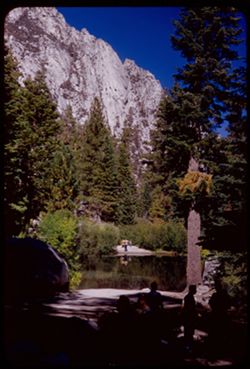
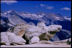
-
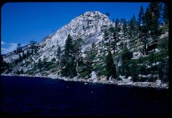
- Description:
- 50 f 9
- Subject:
- Rocks, Piers & wharves, Grasses, Trees, Pines, Rock slopes, Mountains, Rock formations, Lakes & ponds, and Sierra Nevada (Calif. and Nev.)
- Series:
- 8-53
- Creator:
- Cushman, Charles W., 1896-1972
- Date Created:
- 1953-10-09
- Genre:
- Landscape photographs
- Frame Number:
- 22
- County:
- El Dorado
- Abstract:
- Echo Lake from end of pier.
- Call Number:
- P06784
- City:
- Echo Lake
- Country:
- United States
- State/Province:
- California
- Alternate Identifier:
- 853.22
- Persistent URL:
- http://purl.dlib.indiana.edu/iudl/archives/cushman/P06784
- Holding Location:
- Bloomington - University Archives
Wells Library E460
1320 E 10th St.
Bloomington, IN 47405
Contact at archives@indiana.edu, 812-855-1127
-
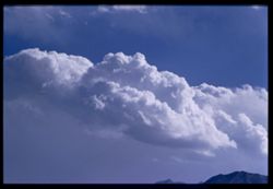
- Description:
- 100 f 8 tl
- Subject:
- Mountains, Clouds, and Sierra Nevada (Calif. and Nev.)
- Series:
- 26-55
- Creator:
- Cushman, Charles W., 1896-1972
- Date Created:
- 1955-09-25
- Genre:
- Landscape photographs
- Frame Number:
- 22
- County:
- Inyo
- Abstract:
- Cloud mass over Sierra - from Bishop
- Call Number:
- P08404
- City:
- Bishop
- Country:
- United States
- State/Province:
- California
- Physical Description:
- Image was originally mounted in a glass enclosure. Before digitization, the image was removed and placed in a Wess Plastic, Inc. brand, 2" x 2", pl...
- Alternate Identifier:
- 2655.22
- Persistent URL:
- http://purl.dlib.indiana.edu/iudl/archives/cushman/P08404
- Holding Location:
- Bloomington - University Archives
Wells Library E460
1320 E 10th St.
Bloomington, IN 47405
Contact at archives@indiana.edu, 812-855-1127
-
- Description:
- 100 f 8 TL
- Subject:
- Trees, Mountains, Pit River Falls (Calif.), Lassen Peak (Calif.), Hills, Plants, and Clouds
- Series:
- 10-58
- Creator:
- Cushman, Charles W., 1896-1972
- Date Created:
- 1958-06-13
- Genre:
- Landscape photographs
- Frame Number:
- 22
- Street Address:
- United States Highway 299
- County:
- Shasta
- Abstract:
- Mt Lassen from same pt above Pit river
- Call Number:
- P09961
- Country:
- United States
- State/Province:
- California
- Alternate Identifier:
- 1058.22
- Persistent URL:
- http://purl.dlib.indiana.edu/iudl/archives/cushman/P09961
- Holding Location:
- Bloomington - University Archives
Wells Library E460
1320 E 10th St.
Bloomington, IN 47405
Contact at archives@indiana.edu, 812-855-1127
-
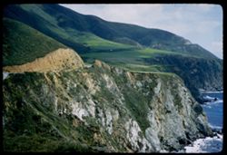
- Description:
- 100 f 4 sl
- Subject:
- Oceans, Seas, Cliffs, Pacific Ocean, Mountains, Bixby Creek (Calif.), Pacific Coast (Calif.), and Hills
- Series:
- 5-57
- Creator:
- Cushman, Charles W., 1896-1972
- Date Created:
- 1957-05-09
- Genre:
- Landscape photographs
- Frame Number:
- 22
- County:
- Monterey
- Abstract:
- Green slopes above
- Call Number:
- P09227
- Country:
- United States
- State/Province:
- California
- Alternate Identifier:
- 557.22
- Persistent URL:
- http://purl.dlib.indiana.edu/iudl/archives/cushman/P09227
- Holding Location:
- Bloomington - University Archives
Wells Library E460
1320 E 10th St.
Bloomington, IN 47405
Contact at archives@indiana.edu, 812-855-1127
-
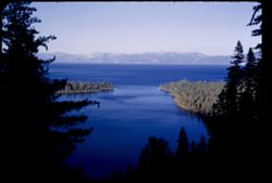
- Description:
- 25 f 9
- Subject:
- Bays (Bodies of water), Trees, Emerald Bay (El Dorado County, Calif.), Tree limbs, Mountains, Tahoe, Lake (Calif. and Nev.), Lakes & ponds, Forests, and ...
- Series:
- 28-52
- Creator:
- Cushman, Charles W., 1896-1972
- Date Created:
- 1952-11-08
- Genre:
- Landscape photographs
- Frame Number:
- 22
- County:
- El Dorado
- Abstract:
- Emerald Bay from Inspiration Pt.
- Call Number:
- P06506
- Country:
- United States
- State/Province:
- California
- Alternate Identifier:
- 2852.22
- Persistent URL:
- http://purl.dlib.indiana.edu/iudl/archives/cushman/P06506
- Holding Location:
- Bloomington - University Archives
Wells Library E460
1320 E 10th St.
Bloomington, IN 47405
Contact at archives@indiana.edu, 812-855-1127
-
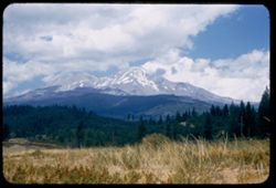
- Description:
- 50 f 9
- Subject:
- Snow, Cascade Range, Trees, Shadows, Lassen Volcanic National Park (Calif.), Mountains, Shrubs, Clouds, Mount Shasta (Calif. : Mountain), Volcanoes, and Stra...
- Series:
- 6-54
- Creator:
- Cushman, Charles W., 1896-1972
- Date Created:
- 1954-08-20
- Genre:
- Landscape photographs
- Frame Number:
- 22
- Street Address:
- United States Highway 99
- County:
- Siskiyou
- Abstract:
- Mt Shasta from US 99.
- Call Number:
- P07239
- Country:
- United States
- State/Province:
- California
- Alternate Identifier:
- 654.22
- Persistent URL:
- http://purl.dlib.indiana.edu/iudl/archives/cushman/P07239
- Holding Location:
- Bloomington - University Archives
Wells Library E460
1320 E 10th St.
Bloomington, IN 47405
Contact at archives@indiana.edu, 812-855-1127
-
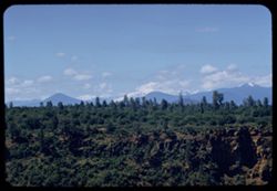
- Description:
- 100 f 8 tl
- Subject:
- Valleys, Roads, Mountains, Shrubs, and Hills
- Series:
- 7-55
- Creator:
- Cushman, Charles W., 1896-1972
- Date Created:
- 1955-03-21
- Genre:
- Landscape photographs
- Frame Number:
- 22
- Street Address:
- Johannesburg Road and Trona Road
- County:
- Kern and San Bernardino
- Abstract:
- Bad Lands west of J - T road
- Call Number:
- P07746
- City:
- Randsburg
- Country:
- United States
- State/Province:
- California
- Alternate Identifier:
- 755.22
- Persistent URL:
- http://purl.dlib.indiana.edu/iudl/archives/cushman/P07746
- Holding Location:
- Bloomington - University Archives
Wells Library E460
1320 E 10th St.
Bloomington, IN 47405
Contact at archives@indiana.edu, 812-855-1127
-
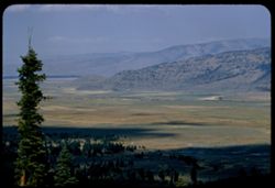
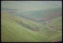
- Description:
- 50 f 8 SL
- Subject:
- Valleys, Bear Valley (Sierra County, Calif.), Trails & paths, Trees, Yuba Pass (Sierra County, Calif.), Mountains, Shrubs, and Hills
- Series:
- 14-54
- Creator:
- Cushman, Charles W., 1896-1972
- Date Created:
- 1954-10-10
- Genre:
- Landscape photographs
- Frame Number:
- 22
- County:
- Sierra
- Abstract:
- East across Bear valley from east slope of Yuba Pass.
- Call Number:
- P07464
- Country:
- United States
- State/Province:
- California
- Alternate Identifier:
- 1454.22
- Persistent URL:
- http://purl.dlib.indiana.edu/iudl/archives/cushman/P07464
- Holding Location:
- Bloomington - University Archives
Wells Library E460
1320 E 10th St.
Bloomington, IN 47405
Contact at archives@indiana.edu, 812-855-1127
-
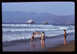
- Description:
- 100 f 8 TL
- Subject:
- Rocks, Families, Swimmers, Seas, Coastlines, Children playing in water, Mountains, Beaches, Bathing suits, Islands, Hills, and Ocean Beach (San Francisco, Ca...
- Series:
- 22-61
- Creator:
- Cushman, Charles W., 1896-1972
- Date Created:
- 1961-10-14
- Genre:
- Ethnographic photographs
- Frame Number:
- 22
- County:
- San Francisco
- Call Number:
- P12513
- City:
- San Francisco
- Country:
- United States
- State/Province:
- California
- Alternate Identifier:
- 2261.22
- Persistent URL:
- http://purl.dlib.indiana.edu/iudl/archives/cushman/P12513
- Holding Location:
- Bloomington - University Archives
Wells Library E460
1320 E 10th St.
Bloomington, IN 47405
Contact at archives@indiana.edu, 812-855-1127
-
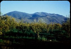
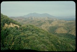
- Description:
- 50 f 8
- Subject:
- Grasses, Trees, Konocti, Mount (Calif.), Meadows, and Mountains
- Series:
- 16-54
- Creator:
- Cushman, Charles W., 1896-1972
- Date Created:
- 1954-11-04
- Genre:
- Landscape photographs
- Frame Number:
- 22
- County:
- Lake
- Abstract:
- Mt Konocti.
- Call Number:
- P07521
- Country:
- United States
- State/Province:
- California
- Physical Description:
- Anscochrome film.
- Alternate Identifier:
- 1654.22
- Persistent URL:
- http://purl.dlib.indiana.edu/iudl/archives/cushman/P07521
- Holding Location:
- Bloomington - University Archives
Wells Library E460
1320 E 10th St.
Bloomington, IN 47405
Contact at archives@indiana.edu, 812-855-1127
-
- Description:
- 25 f 8 pola
- Subject:
- Bays (Bodies of water), Piers & wharves, Warehouses, Tree limbs, Mountains, Peninsulas, Clouds, and Telegraph Hill (San Francisco, Calif.)
- Series:
- 10-52
- Creator:
- Cushman, Charles W., 1896-1972
- Date Created:
- 1952-03-12
- Genre:
- Landscape photographs and Seascapes
- Frame Number:
- 22
- County:
- Alameda and San Francisco
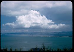
- Abstract:
- Beautiful cloud mass over Berkeley
- Call Number:
- P05853
- City:
- Berkeley and San Francisco
- Country:
- United States
- State/Province:
- California
- Alternate Identifier:
- 1052.22
- Persistent URL:
- http://purl.dlib.indiana.edu/iudl/archives/cushman/P05853
- Holding Location:
- Bloomington - University Archives
Wells Library E460
1320 E 10th St.
Bloomington, IN 47405
Contact at archives@indiana.edu, 812-855-1127
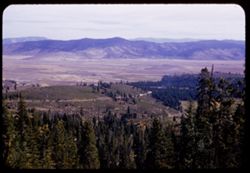
-
- Description:
- 100 f 8 TL
- Subject:
- Farms, Trees, Bear Valley (San Benito County, Calif.), Mountains, Hills, Dry Lake Valley (Calif.), and Buck Ridge (San Benito County, Calif.)
- Series:
- 6-56
- Creator:
- Cushman, Charles W., 1896-1972
- Date Created:
- 1956-04-22
- Genre:
- Landscape photographs
- Frame Number:
- 22
- County:
- San Benito
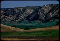
- Abstract:
- Buck Ridge above Floor of S.B. Valley (Bear Valley or Dry Lake Valley)
- Call Number:
- P08731
- Country:
- United States
- State/Province:
- California
- Alternate Identifier:
- 656.22
- Persistent URL:
- http://purl.dlib.indiana.edu/iudl/archives/cushman/P08731
- Holding Location:
- Bloomington - University Archives
Wells Library E460
1320 E 10th St.
Bloomington, IN 47405
Contact at archives@indiana.edu, 812-855-1127
-
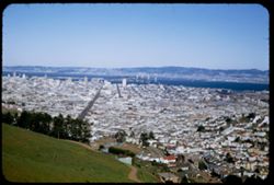
- Description:
- 100 f 6.3 or f 8 tl at 100 ft
- Subject:
- Buildings, Golden Gate Channel (Calif.), Cities & towns, Mountains, Twin Peaks (San Francisco County, Calif.), Roofs, Olympus, Mount (San Francisco Count...
- Series:
- 10-57
- Creator:
- Cushman, Charles W., 1896-1972
- Date Created:
- 1957-07-13
- Genre:
- Cityscape photographs
- Frame Number:
- 22
- Street Address:
- Corbett Avenue
- County:
- San Francisco
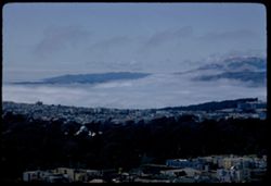
- Abstract:
- 22 to 32 inc.-views from Mt. Olympus, Twin Peaks and Corbett St. viz. NW from Mt. Olympus - fog in GG
- Call Number:
- P09396
- City:
- San Francisco
- Country:
- United States
- State/Province:
- California
- Alternate Identifier:
- 1057.22
- Persistent URL:
- http://purl.dlib.indiana.edu/iudl/archives/cushman/P09396
- Holding Location:
- Bloomington - University Archives
Wells Library E460
1320 E 10th St.
Bloomington, IN 47405
Contact at archives@indiana.edu, 812-855-1127
-
- Description:
- 100 f 11 tl
- Subject:
- Catalpas, Catalpa, Hills, Windows, Mountains, Shrubs, Electric lines, Trees, Fences, and Houses
- Series:
- 16-59
- Creator:
- Cushman, Charles W., 1896-1972
- Date Created:
- 1959-10-03
- Genre:
- Identification photographs
- Frame Number:
- 22
- County:
- Marin
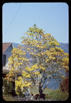
- Abstract:
- Catalpa- Bolinas Bay
- Call Number:
- P10874
- City:
- Bolinas
- Country:
- United States
- State/Province:
- California
- Physical Description:
- Anscochrome film.
- Alternate Identifier:
- 1659.22
- Persistent URL:
- http://purl.dlib.indiana.edu/iudl/archives/cushman/P10874
- Holding Location:
- Bloomington - University Archives
Wells Library E460
1320 E 10th St.
Bloomington, IN 47405
Contact at archives@indiana.edu, 812-855-1127
-
- Description:
- 100 f 6.3 TL
- Subject:
- San Jacinto Peak (Calif.) and Mountains
- Series:
- 24-61
- Creator:
- Cushman, Charles W., 1896-1972
- Date Created:
- 1961-12-29
- Genre:
- Landscape photographs
- Frame Number:
- 22
- Street Address:
- United States Highway 99
- County:
- Riverside
- Abstract:
- Top of San Jacinto and Top of Mt. San Jacinto
- Call Number:
- P12588
- Country:
- United States
- State/Province:
- California
- Alternate Identifier:
- 2461.22
- Persistent URL:
- http://purl.dlib.indiana.edu/iudl/archives/cushman/P12588
- Holding Location:
- Bloomington - University Archives
Wells Library E460
1320 E 10th St.
Bloomington, IN 47405
Contact at archives@indiana.edu, 812-855-1127
-
- Description:
- 100 f 8 TL
- Subject:
- Storms, Santa Ynez Mountains (Calif.), Mountains, Rocks, Plants, Loma Alta (Santa Barbara County, Calif.), Clouds, and San Marcos Pass (Calif.)
- Series:
- 5-56
- Creator:
- Cushman, Charles W., 1896-1972
- Date Created:
- 1956-04-20
- Genre:
- Landscape photographs
- Frame Number:
- 22
- County:
- Santa Barbara
- Abstract:
- Green cloud mtn (Loma alta?)
- Call Number:
- P08695
- Country:
- United States
- State/Province:
- California
- Alternate Identifier:
- 556.22
- Persistent URL:
- http://purl.dlib.indiana.edu/iudl/archives/cushman/P08695
- Holding Location:
- Bloomington - University Archives
Wells Library E460
1320 E 10th St.
Bloomington, IN 47405
Contact at archives@indiana.edu, 812-855-1127
-
- Description:
- 100 f 6.3 tl
- Subject:
- Tree limbs, Plains, Valleys, Yuba Pass (Sierra County, Calif.), Mountains, Shadows, and Bear Valley (Sierra County, Calif.)
- Series:
- 11-57
- Creator:
- Cushman, Charles W., 1896-1972
- Date Created:
- 1957-07-23
- Genre:
- Landscape photographs
- Frame Number:
- 22
- County:
- Sierra
- Abstract:
- Bear Ck Valley from lower down Yuba Pass rd.
- Call Number:
- P09431
- Country:
- United States
- State/Province:
- California
- Alternate Identifier:
- 1157.22
- Persistent URL:
- http://purl.dlib.indiana.edu/iudl/archives/cushman/P09431
- Holding Location:
- Bloomington - University Archives
Wells Library E460
1320 E 10th St.
Bloomington, IN 47405
Contact at archives@indiana.edu, 812-855-1127
-
- Description:
- 100 f 6.3 tl
- Subject:
- Black Mountains (Inyo County, Calif.), Death Valley (Calif. and Nev.), Mountains, Rocks, Clouds, and Rock formations
- Series:
- 3-55
- Creator:
- Cushman, Charles W., 1896-1972
- Date Created:
- 1955-02-27
- Genre:
- Landscape photographs
- Frame Number:
- 22
- Street Address:
- Bad Water Road
- County:
- Inyo
- Abstract:
- Red stripe across Black Mtns
- Call Number:
- P07613
- Country:
- United States
- State/Province:
- California
- Alternate Identifier:
- 355.22
- Persistent URL:
- http://purl.dlib.indiana.edu/iudl/archives/cushman/P07613
- Holding Location:
- Bloomington - University Archives
Wells Library E460
1320 E 10th St.
Bloomington, IN 47405
Contact at archives@indiana.edu, 812-855-1127
-
- Description:
- 50 f 5.6 Pola
- Subject:
- Diablo, Mount (Calif.), Vessels, Streets, Automobiles, Roads, Bridges, Mountains, Dwellings, Trees, Buildings, Signs (Notices), Twin Peaks (San Francisco Cou...
- Series:
- 2-53
- Creator:
- Cushman, Charles W., 1896-1972
- Date Created:
- 1953-02-08
- Genre:
- Cityscape photographs
- Frame Number:
- 22
- Street Address:
- Mission
- County:
- San Francisco
- Abstract:
- Looking down from Twin Peaks ENE.
- Call Number:
- P06556
- City:
- San Francisco
- Country:
- United States
- State/Province:
- California
- Alternate Identifier:
- 253.22
- Persistent URL:
- http://purl.dlib.indiana.edu/iudl/archives/cushman/P06556
- Holding Location:
- Bloomington - University Archives
Wells Library E460
1320 E 10th St.
Bloomington, IN 47405
Contact at archives@indiana.edu, 812-855-1127
-
- Description:
- 50 f 9
- Subject:
- Bodies of water, Trees, Boulders, Shadows, Mountains, Shrubs, Lakes & ponds, Whitney, Mount (Calif.), People, and Reflections
- Series:
- 12-54
- Creator:
- Cushman, Charles W., 1896-1972
- Date Created:
- 1954-09-18
- Genre:
- Landscape photographs
- Frame Number:
- 22
- Street Address:
- Mt. Whitney Road
- County:
- Inyo
- Abstract:
- Vacationers at Mt Whitney Portal campground.
- Call Number:
- P07412
- Country:
- United States
- State/Province:
- California
- Alternate Identifier:
- 1254.22
- Persistent URL:
- http://purl.dlib.indiana.edu/iudl/archives/cushman/P07412
- Holding Location:
- Bloomington - University Archives
Wells Library E460
1320 E 10th St.
Bloomington, IN 47405
Contact at archives@indiana.edu, 812-855-1127
-
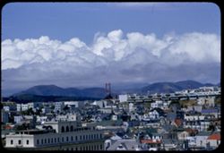
![[No Description]](https://iiif.uits.iu.edu/iiif/2/1z40kt54k%2Ffiles%2F057d1acc-6070-47f4-999c-05bc2dd67864/full/250,/0/default.jpg)
- Description:
- 100 f 4
- Subject:
- Golden Gate Bridge (San Francisco, Calif.), Suspension bridges, Tree limbs, Mountains, Buildings, Bridges, Sunrises & sunsets, Hills, and Clouds
- Series:
- 13-59
- Creator:
- Cushman, Charles W., 1896-1972
- Date Created:
- 1959-07-09
- Genre:
- Architectural photographs
- Frame Number:
- 22
- County:
- San Francisco
- Abstract:
- Sunset - Golden Gate Half frame
- Call Number:
- P10818
- City:
- San Francisco
- Country:
- United States
- State/Province:
- California
- Physical Description:
- masked.
- Alternate Identifier:
- 1359.22
- Persistent URL:
- http://purl.dlib.indiana.edu/iudl/archives/cushman/P10818
- Holding Location:
- Bloomington - University Archives
Wells Library E460
1320 E 10th St.
Bloomington, IN 47405
Contact at archives@indiana.edu, 812-855-1127
-
- Description:
- 25 f 6.3 Pola
- Subject:
- Trees, Mount Wilson (Calif.), Mountains, and Shrubs
- Series:
- 6-52
- Creator:
- Cushman, Charles W., 1896-1972
- Date Created:
- 1952-02-18
- Genre:
- Landscape photographs
- Frame Number:
- 22
- County:
- Los Angeles
- Abstract:
- WNW from Mt. Wilson
- Call Number:
- P05705
- Country:
- United States
- State/Province:
- California
- Alternate Identifier:
- 652.22
- Persistent URL:
- http://purl.dlib.indiana.edu/iudl/archives/cushman/P05705
- Holding Location:
- Bloomington - University Archives
Wells Library E460
1320 E 10th St.
Bloomington, IN 47405
Contact at archives@indiana.edu, 812-855-1127
-
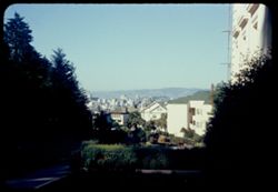
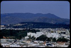
- Description:
- 50 f 8
- Subject:
- Trees, Flowers, St. Joseph's Hospital (San Francisco, Calif.), Mountains, Buildings, Shrubs, Dwellings, and Walkways
- Series:
- 3-54
- Creator:
- Cushman, Charles W., 1896-1972
- Date Created:
- 1954-07-05
- Genre:
- Cityscape photographs
- Frame Number:
- 22
- Street Address:
- Buena Vista Avenue East
- County:
- San Francisco
- Abstract:
- S.F. business district seen from Buena Vista East alongside St. Joseph's Hospital
- Call Number:
- P07173
- City:
- San Francisco
- Country:
- United States
- State/Province:
- California
- Physical Description:
- Anscochrome film.
- Alternate Identifier:
- 254.22
- Persistent URL:
- http://purl.dlib.indiana.edu/iudl/archives/cushman/P07173
- Holding Location:
- Bloomington - University Archives
Wells Library E460
1320 E 10th St.
Bloomington, IN 47405
Contact at archives@indiana.edu, 812-855-1127
-
- Description:
- 100 f 6 tl
- Subject:
- Electric lines, Golden Gate Bridge (San Francisco, Calif.), Suspension bridges, Trees, Roofs, Streets, Mountains, Buildings, Clouds, Dwellings, Hills, and Ut...
- Series:
- 14-55
- Creator:
- Cushman, Charles W., 1896-1972
- Date Created:
- 1955-04-29
- Genre:
- Cityscape photographs
- Frame Number:
- 22
- Street Address:
- 100 Broderick Street
- County:
- San Francisco
- Abstract:
- Clouds over Golden Gate - from top of 100 Broderick
- Call Number:
- P07992
- City:
- San Francisco
- Country:
- United States
- State/Province:
- California
- Alternate Identifier:
- 1455.22
- Persistent URL:
- http://purl.dlib.indiana.edu/iudl/archives/cushman/P07992
- Holding Location:
- Bloomington - University Archives
Wells Library E460
1320 E 10th St.
Bloomington, IN 47405
Contact at archives@indiana.edu, 812-855-1127
-
- Description:
- 50 f 10
- Subject:
- Snow, Boulders, Mountains, Shrubs, Whitney, Mount (Calif.), Sierra Nevada (Calif. and Nev.), and Hills
- Series:
- 14-52
- Creator:
- Cushman, Charles W., 1896-1972
- Date Created:
- 1952-04-08
- Genre:
- Landscape photographs
- Frame Number:
- 22
- Street Address:
- Mount Whitney Road
- County:
- Inyo
- Abstract:
- And those to north.
- Call Number:
- P06006
- City:
- Lone Pine
- Country:
- United States
- State/Province:
- California
- Alternate Identifier:
- 1452.22
- Persistent URL:
- http://purl.dlib.indiana.edu/iudl/archives/cushman/P06006
- Holding Location:
- Bloomington - University Archives
Wells Library E460
1320 E 10th St.
Bloomington, IN 47405
Contact at archives@indiana.edu, 812-855-1127
-
- Description:
- 100 f 4 TL
- Subject:
- Rocks, Valleys, Roads, Tehachapi Mountains (Calif.), Mountains, and Hills
- Series:
- 3-69
- Creator:
- Cushman, Charles W., 1896-1972
- Date Created:
- 1969-03-21
- Genre:
- Landscape photographs
- Frame Number:
- 22
- Street Address:
- California State Highway 58
- County:
- Kern
- Abstract:
- Lower along Hwy 58
- Call Number:
- P15774
- City:
- Tehachapi and Bakersfield
- Country:
- United States
- State/Province:
- California
- Alternate Identifier:
- 369.22
- Persistent URL:
- http://purl.dlib.indiana.edu/iudl/archives/cushman/P15774
- Holding Location:
- Bloomington - University Archives
Wells Library E460
1320 E 10th St.
Bloomington, IN 47405
Contact at archives@indiana.edu, 812-855-1127
-
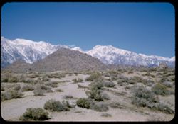
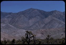
- Description:
- 50 f 11
- Subject:
- Deserts, Valleys, White Mountains (Calif. and Nev.), Dirt roads, Sand, Owens Valley (Calif.), Mountains, Shrubs, Dwellings, and Farms
- Series:
- 11-54
- Creator:
- Cushman, Charles W., 1896-1972
- Date Created:
- 1954-09-17
- Genre:
- Landscape photographs
- Frame Number:
- 22
- County:
- Inyo
- Abstract:
- White Mtns. have color. In center should be White Mtn. (14,242 ft.)
- Call Number:
- P07391
- Country:
- United States
- State/Province:
- California
- Physical Description:
- Image was originally mounted in a glass enclosure. Before digitization, the image was removed and placed in a Wess Plastic, Inc. brand, 2" x 2", pl...
- Alternate Identifier:
- 1154.22
- Persistent URL:
- http://purl.dlib.indiana.edu/iudl/archives/cushman/P07391
- Holding Location:
- Bloomington - University Archives
Wells Library E460
1320 E 10th St.
Bloomington, IN 47405
Contact at archives@indiana.edu, 812-855-1127
-
- Description:
- 100 f 5.6 tl
- Subject:
- Trees, Castle Crags Wilderness (Calif.), Mountains, and Clouds
- Series:
- 17-55
- Creator:
- Cushman, Charles W., 1896-1972
- Date Created:
- 1955-06-16
- Genre:
- Landscape photographs
- Frame Number:
- 22
- Street Address:
- United States Highway 99
- County:
- Siskiyou and Shasta
- Abstract:
- From Hwy 99 - 47 1/2 mi. north of Redding (65666 mi) a view of Castle Crgs
- Call Number:
- P08102
- City:
- Redding and Dunsmuir
- Country:
- United States
- State/Province:
- California
- Alternate Identifier:
- 1755.22
- Persistent URL:
- http://purl.dlib.indiana.edu/iudl/archives/cushman/P08102
- Holding Location:
- Bloomington - University Archives
Wells Library E460
1320 E 10th St.
Bloomington, IN 47405
Contact at archives@indiana.edu, 812-855-1127
-
- Description:
- 100 f 8 tl
- Subject:
- Deserts, Mojave Desert (Calif.), Joshua trees, Mountains, Clark Mountain (San Bernardino County, Calif.), Yucca, and Plants
- Series:
- 3-58
- Creator:
- Cushman, Charles W., 1896-1972
- Date Created:
- 1958-04-25
- Genre:
- Landscape photographs
- Frame Number:
- 22
- County:
- San Bernardino
- Abstract:
- Joshua Trees and Yucca below Clark Mtn
- Call Number:
- P09738
- Country:
- United States
- State/Province:
- California
- Alternate Identifier:
- 358.22
- Persistent URL:
- http://purl.dlib.indiana.edu/iudl/archives/cushman/P09738
- Holding Location:
- Bloomington - University Archives
Wells Library E460
1320 E 10th St.
Bloomington, IN 47405
Contact at archives@indiana.edu, 812-855-1127
-
- Description:
- 100 f 9 tl
- Subject:
- Red Peak (Calif.), Trees, Half Dome (Calif.), Mountains, Rock formations, Clouds, and Shrubs
- Series:
- 20-55
- Creator:
- Cushman, Charles W., 1896-1972
- Date Created:
- 1955-07-07
- Genre:
- Landscape photographs
- Frame Number:
- 22
- County:
- Mariposa
- Abstract:
- Toward Red Pk
- Call Number:
- P08205
- Country:
- United States
- State/Province:
- California
- Physical Description:
- Image was originally mounted in a glass enclosure. Before digitization, the image was removed and placed in a Wess Plastic, Inc. brand, 2" x 2", pl...
- Alternate Identifier:
- 2055.22
- Persistent URL:
- http://purl.dlib.indiana.edu/iudl/archives/cushman/P08205
- Holding Location:
- Bloomington - University Archives
Wells Library E460
1320 E 10th St.
Bloomington, IN 47405
Contact at archives@indiana.edu, 812-855-1127
-
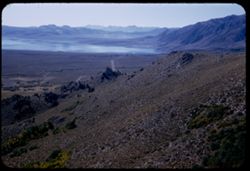
- Description:
- 50 f 8
- Subject:
- Bodies of water, Roads, Trees, Mountains, Shrubs, Lakes & ponds, Hills, and Mono Lake (Calif.)
- Series:
- 9-54
- Creator:
- Cushman, Charles W., 1896-1972
- Date Created:
- 1954-09-16
- Genre:
- Landscape photographs
- Frame Number:
- 22
- Street Address:
- United States Highway 395
- County:
- Mono
- Abstract:
- Looking down from north on west end of Mono Lake.
- Call Number:
- P07333
- Country:
- United States
- State/Province:
- California
- Alternate Identifier:
- 954.22
- Persistent URL:
- http://purl.dlib.indiana.edu/iudl/archives/cushman/P07333
- Holding Location:
- Bloomington - University Archives
Wells Library E460
1320 E 10th St.
Bloomington, IN 47405
Contact at archives@indiana.edu, 812-855-1127
-
- Description:
- 50 f 8
- Subject:
- Rocks, Valleys, Lee Vining Canyon (Calif.), Roads, Mono Basin (Calif.), Trees, Lee Vining Creek (Calif.), Mountains, Shrubs, and Canyons
- Series:
- 10-54
- Creator:
- Cushman, Charles W., 1896-1972
- Date Created:
- 1954-09-16
- Genre:
- Landscape photographs
- Frame Number:
- 22
- County:
- Mono
- Abstract:
- Another view east down canyon - a little vurther along.
- Call Number:
- P07369
- Country:
- United States
- State/Province:
- California
- Physical Description:
- Anscochrome film.
- Alternate Identifier:
- 1054.22
- Persistent URL:
- http://purl.dlib.indiana.edu/iudl/archives/cushman/P07369
- Holding Location:
- Bloomington - University Archives
Wells Library E460
1320 E 10th St.
Bloomington, IN 47405
Contact at archives@indiana.edu, 812-855-1127
-
- Description:
- 100 f 6.3 tl
- Subject:
- Valleys, Bodies of water, Olympus, Mount (San Francisco County, Calif.), Automobiles, Trees, Signs (Notices), Streets, Mountains, Buildings, Dwellings, Hills...
- Series:
- 5-55
- Creator:
- Cushman, Charles W., 1896-1972
- Date Created:
- 1955-03-13
- Genre:
- Cityscape photographs
- Frame Number:
- 22
- County:
- San Francisco
- Abstract:
- From Mt. Olympus - toward Tamalpais & to Kozar were out too far to left and had to be remounted
- Call Number:
- P07687
- City:
- San Francisco
- Country:
- United States
- State/Province:
- California
- Alternate Identifier:
- 555.22
- Persistent URL:
- http://purl.dlib.indiana.edu/iudl/archives/cushman/P07687
- Holding Location:
- Bloomington - University Archives
Wells Library E460
1320 E 10th St.
Bloomington, IN 47405
Contact at archives@indiana.edu, 812-855-1127