
Search Constraints
You searched for:
Campus
IUB
Remove constraint Campus: IUB
Frame Number
5
Remove constraint Frame Number: 5
Pages
0-99 pages
Remove constraint Pages: 0-99 pages
Subject
Mountains
Remove constraint Subject: Mountains
1 - 98 of 98
Search Results
-
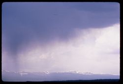
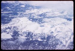
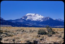
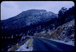
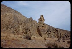
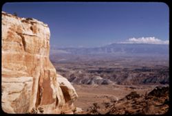
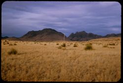
- Description:
- 100 f 11 tl
- Subject:
- Snow, Storms, Mountains, Clouds, and Uinta Mountains (Utah and Wyo.)
- Series:
- 10-66
- Creator:
- Cushman, Charles W., 1896-1972
- Date Created:
- 1966-06-17
- Genre:
- Landscape photographs and Snapshots
- Frame Number:
- 5
- Abstract:
- Storm clouds over mountains
- Call Number:
- P15445
- Country:
- United States
- State/Province:
- Utah
- Alternate Identifier:
- 1066.5
- Persistent URL:
- http://purl.dlib.indiana.edu/iudl/archives/cushman/P15445
-
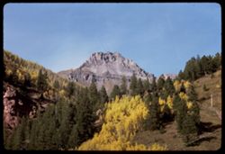
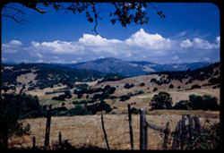
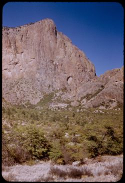
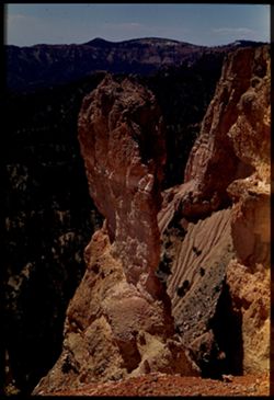
- Description:
- 100 f 11 TL
- Subject:
- Forests, Cliffs, San Juan Mountains (Colo. and N.M.), Mountains, Trees, and Rock formations
- Series:
- 36-65
- Creator:
- Cushman, Charles W., 1896-1972
- Date Created:
- 1965-10-05
- Genre:
- Landscape photographs
- Frame Number:
- 5
- County:
- San Miguel
- Abstract:
- Up from Telluride.
- Call Number:
- P15073
- City:
- Telluride
- Country:
- United States
- State/Province:
- Colorado
- Alternate Identifier:
- 3665.5
- Persistent URL:
- http://purl.dlib.indiana.edu/iudl/archives/cushman/P15073
-
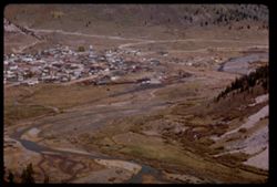
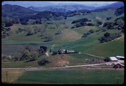
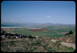
- Description:
- 100 f 16 tl
- Subject:
- Valleys, Houses, Trees, Mountains, Buildings, Railroads, Rivers, and Roads
- Series:
- 33-65
- Creator:
- Cushman, Charles W., 1896-1972
- Date Created:
- 1965-10-02
- Genre:
- Cityscape photographs
- Frame Number:
- 5
- County:
- San Juan
- Abstract:
- Silverton below
- Call Number:
- P14960
- City:
- Silverton
- Country:
- United States
- State/Province:
- Colorado
- Alternate Identifier:
- 3365.5
- Persistent URL:
- http://purl.dlib.indiana.edu/iudl/archives/cushman/P14960
-
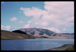
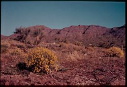
- Description:
- 100 f 11
- Subject:
- Lakes & ponds, Black Mountain (Marin County, Calif.), Hills, Mountains, Coastlines, and Clouds
- Series:
- 27-65
- Creator:
- Cushman, Charles W., 1896-1972
- Date Created:
- 1965-07-26
- Genre:
- Landscape photographs
- Frame Number:
- 5
- County:
- Marin
- Abstract:
- Black Mtn.
- Call Number:
- P14804
- Country:
- United States
- State/Province:
- California
- Alternate Identifier:
- 2765.5
- Persistent URL:
- http://purl.dlib.indiana.edu/iudl/archives/cushman/P14804
-
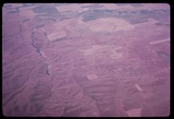
- Subject:
- Valleys, Mountains, Air travel, Rivers, and Croplands
- Series:
- 26-65
- Creator:
- Cushman, Charles W., 1896-1972
- Date Created:
- 1965-06-02
- Genre:
- Aerial photographs and Landscape photographs
- Frame Number:
- 5
- Call Number:
- P14766
- Country:
- United States
- State/Province:
- Oregon
- Alternate Identifier:
- 2565.5
- Persistent URL:
- http://purl.dlib.indiana.edu/iudl/archives/cushman/P14766
-
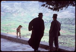
- Subject:
- Men, Valleys, Dogs, Hosios Loukas (Monastery : Voiotia, Greece), Tree limbs, Mountains, and Croplands
- Series:
- 12-65
- Creator:
- Cushman, Charles W., 1896-1972
- Date Created:
- 1965-04-21
- Genre:
- Views and Portraits
- Frame Number:
- 5
- County:
- Voiotia
- Abstract:
- Fields below
- Call Number:
- P14243
- Country:
- Greece
- State/Province:
- Central Greece and Euboea
- Alternate Identifier:
- 1265.5
- Persistent URL:
- http://purl.dlib.indiana.edu/iudl/archives/cushman/P14243
-
- Subject:
- Valleys, Pan American World Airways, inc., Mountains, and Air travel
- Series:
- 2-65
- Creator:
- Cushman, Charles W., 1896-1972
- Date Created:
- 1965-03-30
- Genre:
- Landscape photographs
- Frame Number:
- 5
- Call Number:
- P13890
- Country:
- United States
- State/Province:
- Utah
- Alternate Identifier:
- 265.5
- Persistent URL:
- http://purl.dlib.indiana.edu/iudl/archives/cushman/P13890
-
- Description:
- 200 f 5.6
- Subject:
- Valleys, Hills, Mountains, Air travel, and Lakes & ponds
- Series:
- 1-65
- Creator:
- Cushman, Charles W., 1896-1972
- Date Created:
- 1965-03-30
- Genre:
- Aerial photographs and Landscape photographs
- Frame Number:
- 5
- County:
- Los Angeles
- Abstract:
- California Fields north of Los Angeles and Over mountains and fields on way to L.A.
- Call Number:
- P13869
- City:
- Los Angeles
- Country:
- United States
- State/Province:
- California
- Alternate Identifier:
- 165.5
- Persistent URL:
- http://purl.dlib.indiana.edu/iudl/archives/cushman/P13869
-
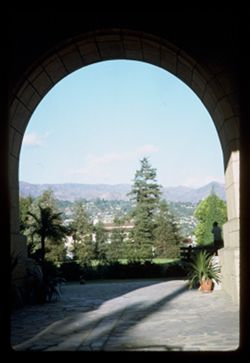
- Subject:
- Arches, Plant containers, Courthouses, Mountains, Trees, Shadows, Plants, and Palms
- Series:
- 26-64
- Creator:
- Cushman, Charles W., 1896-1972
- Date Created:
- 1964-12-02
- Genre:
- Landscape photographs, Cityscape photographs, and Views
- Frame Number:
- 5
- County:
- Santa Barbara
- Abstract:
- Santa Barbara Court House
- Call Number:
- P13804
- City:
- Santa Barbara
- Country:
- United States
- State/Province:
- California
- Alternate Identifier:
- 2664.5
- Persistent URL:
- http://purl.dlib.indiana.edu/iudl/archives/cushman/P13804
-
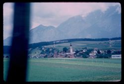
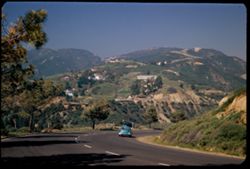
- Description:
- 100 f 5.6
- Subject:
- Towers, Spires, Valleys, Trees, City & town halls, Mountains, Churches, Stubay Valley (Austria), Dwellings, Hills, Croplands, and Buildings
- Series:
- 17-64
- Creator:
- Cushman, Charles W., 1896-1972
- Date Created:
- 1964-06-09
- Genre:
- Landscape photographs and Cityscape photographs
- Frame Number:
- 5
- Call Number:
- P13546
- City:
- Innsbruck and Mutters
- Country:
- Austria
- State/Province:
- Tyrol
- Alternate Identifier:
- 1764.5
- Persistent URL:
- http://purl.dlib.indiana.edu/iudl/archives/cushman/P13546
-
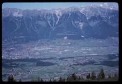
- Description:
- 100 f 11
- Subject:
- Valleys, Forests, Cities & towns, Mountains, Trees, Alps, Austrian (Austria), Snow, Rivers, and Patscherkofel (Austria)
- Series:
- 15-64
- Creator:
- Cushman, Charles W., 1896-1972
- Date Created:
- 1964-06-04
- Genre:
- Landscape photographs and Cityscape photographs
- Frame Number:
- 5
- Call Number:
- P13470
- City:
- Innsbruck
- Country:
- Austria
- State/Province:
- Tyrol
- Alternate Identifier:
- 1564.5
- Persistent URL:
- http://purl.dlib.indiana.edu/iudl/archives/cushman/P13470
-
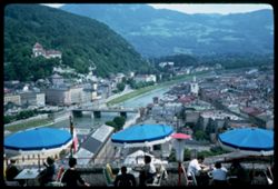
- Description:
- 100 f 11
- Subject:
- Salzach River (Austria and Germany), Monasteries, Kapuzinerberg (Salzburg, Austria), Cafes, Umbrellas, Mountains, Eating & drinking, Tables, Bridges, Clo...
- Series:
- 12-64
- Creator:
- Cushman, Charles W., 1896-1972
- Date Created:
- 1964-05-30
- Genre:
- Cityscape photographs and Ethnographic photographs
- Frame Number:
- 5
- Abstract:
- From Winkler on Monchsberg
- Call Number:
- P13358
- City:
- Salzburg
- Country:
- Austria
- State/Province:
- Salzburg
- Alternate Identifier:
- 1264.5
- Persistent URL:
- http://purl.dlib.indiana.edu/iudl/archives/cushman/P13358
-
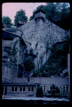
- Description:
- 100 f 5.6
- Subject:
- Stone walls, Vines, Windows, Mountains, Shrubs, Trees, Buildings, Watch towers, Monasteries, and Kapuzinerberg (Salzburg, Austria)
- Series:
- 11-64
- Creator:
- Cushman, Charles W., 1896-1972
- Date Created:
- 1964-05-27
- Genre:
- Architectural photographs
- Frame Number:
- 5
- Abstract:
- View up Kapuzinerberg
- Call Number:
- P13320
- City:
- Salzburg
- Country:
- Austria
- State/Province:
- Salzburg
- Alternate Identifier:
- 1164.5
- Persistent URL:
- http://purl.dlib.indiana.edu/iudl/archives/cushman/P13320
-
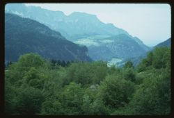
- Description:
- 100 f 8
- Subject:
- Obersalzberg (Germany), Valleys, Forests, Mountains, and Trees
- Series:
- 10-64
- Creator:
- Cushman, Charles W., 1896-1972
- Date Created:
- 1964-05-25
- Genre:
- Landscape photographs
- Frame Number:
- 5
- County:
- Oberbayern
- Abstract:
- From Obersalzberg
- Call Number:
- P13283
- City:
- Berchtesgaden
- Country:
- Germany
- State/Province:
- Bavaria
- Alternate Identifier:
- 1064.5
- Persistent URL:
- http://purl.dlib.indiana.edu/iudl/archives/cushman/P13283
-
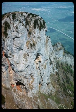
- Description:
- 200 f 5.6
- Subject:
- Untersberg (Austria), Cliffs, Trails & paths, Trees, Mountains, and Rock formations
- Series:
- 9-64
- Creator:
- Cushman, Charles W., 1896-1972
- Date Created:
- 1964-05-24
- Genre:
- Landscape photographs
- Frame Number:
- 5
- Call Number:
- P13245
- City:
- Salzburg
- Country:
- Austria
- State/Province:
- Salzburg
- Alternate Identifier:
- 964.5
- Persistent URL:
- http://purl.dlib.indiana.edu/iudl/archives/cushman/P13245
-
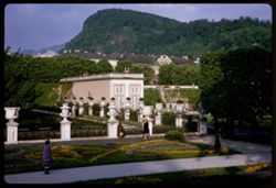
- Description:
- 100 f 6.3
- Subject:
- Pedestrians, Kapuzinerberg (Salzburg, Austria), Trees, Flowers, Walkways, Gardens, Mountains, Fences, Shrubs, Mirabellgarten (Salzburg, Austria), Buildings, ...
- Series:
- 8-64
- Creator:
- Cushman, Charles W., 1896-1972
- Date Created:
- 1964-05-21
- Genre:
- Views and Cityscape photographs
- Frame Number:
- 5
- Abstract:
- Kapuzinerberg from Mirabell Garden
- Call Number:
- P13207
- City:
- Salzburg
- Country:
- Austria
- State/Province:
- Salzburg
- Alternate Identifier:
- 864.5
- Persistent URL:
- http://purl.dlib.indiana.edu/iudl/archives/cushman/P13207
-

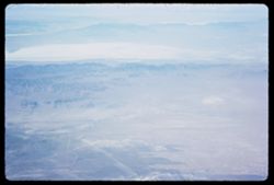
- Description:
- 200 f 8
- Subject:
- Snow, Mountains, Air travel, Clouds, and Land
- Series:
- 2-64
- Creator:
- Cushman, Charles W., 1896-1972
- Date Created:
- 1964-04-29
- Genre:
- Aerial photographs
- Frame Number:
- 5
- Abstract:
- Wyoming
- Call Number:
- P12997
- Country:
- United States
- State/Province:
- Wyoming
- Alternate Identifier:
- 264.5
- Persistent URL:
- http://purl.dlib.indiana.edu/iudl/archives/cushman/P12997
-
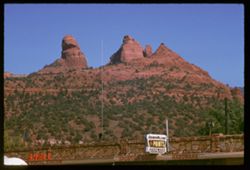
- Description:
- 100 f 13 TL
- Subject:
- Erosion, Chimneys, Hardware stores, Sporting goods stores, Cliffs, Mountains, Utility poles, Sherwin-Williams Company, Trees, Television antennas, Signs (Not...
- Series:
- 5-62
- Creator:
- Cushman, Charles W., 1896-1972
- Date Created:
- 1962-10-05
- Genre:
- Landscape photographs and Views
- Frame Number:
- 5
- County:
- Coconino
- Abstract:
- Mtns East from Sedona
- Call Number:
- P12772
- City:
- Sedona
- Country:
- United States
- State/Province:
- Arizona
- Alternate Identifier:
- 562.5
- Persistent URL:
- http://purl.dlib.indiana.edu/iudl/archives/cushman/P12772
-
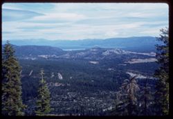
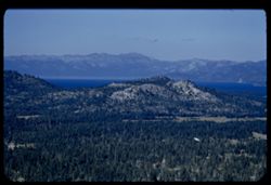
- Description:
- 50 f 8
- Subject:
- Echo Summit (El Dorado County, Calif.), Trees, Mountains, Tahoe, Lake (Calif. and Nev.), Lakes & ponds, Clouds, Sierra Nevada (Calif. and Nev.), Forests,...
- Series:
- 3-62
- Creator:
- Cushman, Charles W., 1896-1972
- Date Created:
- 1962-09-28
- Genre:
- Landscape photographs
- Frame Number:
- 5
- Abstract:
- Toward Tahoe.
- Call Number:
- P12703
- Country:
- United States
- State/Province:
- California
- Alternate Identifier:
- 362.5
- Persistent URL:
- http://purl.dlib.indiana.edu/iudl/archives/cushman/P12703
-
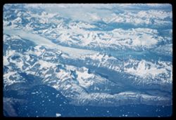
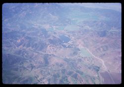
- Description:
- 200 f
- Subject:
- Snow, Oceans, Ice, Coastlines, Pan American World Airways, inc., Mountains, Air travel, and Icebergs
- Series:
- 21-61
- Creator:
- Cushman, Charles W., 1896-1972
- Date Created:
- 1961-06-29
- Genre:
- Aerial photographs and Landscape photographs
- Frame Number:
- 5
- Abstract:
- Above Greenland's icy mountains and Over Greenland
- Call Number:
- P12461
- Country:
- Greenland
- Alternate Identifier:
- 2161.5
- Persistent URL:
- http://purl.dlib.indiana.edu/iudl/archives/cushman/P12461
-
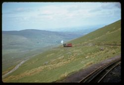
- Description:
- 500 f 2
- Subject:
- Valleys, Hills, Railroad tracks, Mountains, Mountain railroads, Railroad travel, Trails & paths, Clouds, and Snowdon (Wales)
- Series:
- 12-61
- Creator:
- Cushman, Charles W., 1896-1972
- Date Created:
- 1961-05-25
- Genre:
- Landscape photographs and Snapshots
- Frame Number:
- 5
- Abstract:
- at water stop 1641 ft the other engine down bound - half way point
- Call Number:
- P12127
- Country:
- United Kingdom
- State/Province:
- Wales
- Alternate Identifier:
- 1261.5
- Persistent URL:
- http://purl.dlib.indiana.edu/iudl/archives/cushman/P12127
-
- Subject:
- Snow, Boeing 707 (Jet transports), Polar regions, Pan American World Airways, inc., Mountains, Boeing Aerospace Company, and Clouds
- Series:
- 3-61
- Creator:
- Cushman, Charles W., 1896-1972
- Date Created:
- 1961-04-21
- Genre:
- Aerial photographs
- Frame Number:
- 5
- Call Number:
- P11793
- Alternate Identifier:
- 361.5
- Persistent URL:
- http://purl.dlib.indiana.edu/iudl/archives/cushman/P11793
-
- Description:
- 100 f 6.3 tl
- Subject:
- Columbia River, Shadows, Mountains, Clouds, Hills, and Rivers
- Series:
- 25-60
- Creator:
- Cushman, Charles W., 1896-1972
- Date Created:
- 1960-09-24
- Genre:
- Landscape photographs
- Frame Number:
- 5
- County:
- Sherman
- Abstract:
- Up river from west of Biggs
- Call Number:
- P11693
- City:
- Biggs
- Country:
- United States
- State/Province:
- Oregon
- Alternate Identifier:
- 2560.5
- Persistent URL:
- http://purl.dlib.indiana.edu/iudl/archives/cushman/P11693
-

- Description:
- 100 f 5.6
- Subject:
- Bodies of water, Buildings, Meta (Ship), Mountains, Trees, Lifeboats, Vines, Walls, Ships, and Cliffs
- Series:
- 13-60
- Creator:
- Cushman, Charles W., 1896-1972
- Date Created:
- 1960-05-27
- Genre:
- Marine photographs and Cityscape photographs
- Frame Number:
- 5
- County:
- Naples
- Abstract:
- META in bound
- Call Number:
- P11287
- City:
- Sorrento
- Country:
- Italy
- State/Province:
- Campania
- Alternate Identifier:
- 1360.5
- Persistent URL:
- http://purl.dlib.indiana.edu/iudl/archives/cushman/P11287
-
- Subject:
- Houses, Trees, Croplands, Buildings, Shrubs, Hills, and Mountains
- Series:
- 8-60
- Creator:
- Cushman, Charles W., 1896-1972
- Date Created:
- 1960-05-16
- Genre:
- Landscape photographs and Cityscape photographs
- Frame Number:
- 5
- County:
- Alpes-Maritimes
- Call Number:
- P11105
- City:
- Vence
- Country:
- France
- State/Province:
- Provence-Alpes-Côte d'Azur
- Alternate Identifier:
- 860.5
- Persistent URL:
- http://purl.dlib.indiana.edu/iudl/archives/cushman/P11105
-
- Description:
- 100 f 6.3 tl
- Subject:
- Bays (Bodies of water), San Francisco Bay Area (Calif.), Mountains, Hills, Golden Gate Channel (Calif.), Channels, and Tankers
- Series:
- 1-60
- Creator:
- Cushman, Charles W., 1896-1972
- Date Created:
- 1960-01-16
- Genre:
- Marine photographs
- Frame Number:
- 5
- County:
- San Francisco
- Abstract:
- Two tankers in Golden Gate
- Call Number:
- P10899
- City:
- San Francisco
- Country:
- United States
- State/Province:
- California
- Alternate Identifier:
- 160.5
- Persistent URL:
- http://purl.dlib.indiana.edu/iudl/archives/cushman/P10899
-
- Description:
- 100 f 6.3 TL
- Subject:
- Valleys, Roads, Outbuildings, Meadows, Mountains, Fences, Gaviota Pass (Calif.), Cows, Hills, Utility poles, Houses, and Passes (Landforms)
- Series:
- 12-59
- Creator:
- Cushman, Charles W., 1896-1972
- Date Created:
- 1959-03-31
- Genre:
- Landscape photographs
- Frame Number:
- 5
- Street Address:
- United States Highway 101
- County:
- Santa Barbara
- Abstract:
- Cows in distant meadow east of Gaviota Pass
- Call Number:
- P10767
- Country:
- United States
- State/Province:
- California
- Alternate Identifier:
- 1259.5
- Persistent URL:
- http://purl.dlib.indiana.edu/iudl/archives/cushman/P10767
-
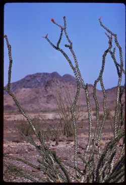
- Description:
- 100 f 8 tl
- Subject:
- Rocks, Flowers, Mountains, Ocotillo, and Shrubs
- Series:
- 11-59
- Creator:
- Cushman, Charles W., 1896-1972
- Date Created:
- 1959-03-24
- Genre:
- Identification photographs
- Frame Number:
- 5
- County:
- Yuma
- Abstract:
- Ocotillo (Quartzsite area)
- Call Number:
- P10730
- City:
- Quartzsite
- Country:
- United States
- State/Province:
- Arizona
- Alternate Identifier:
- 1159.5
- Persistent URL:
- http://purl.dlib.indiana.edu/iudl/archives/cushman/P10730
-
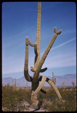
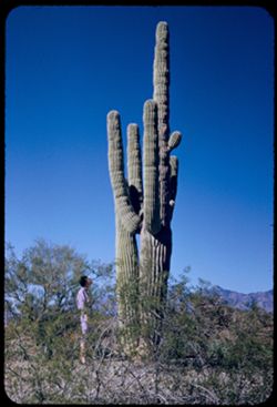
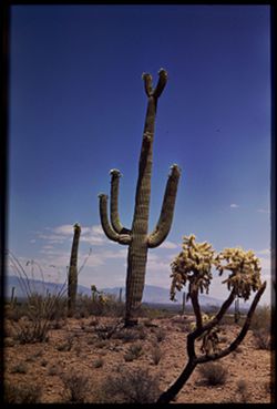
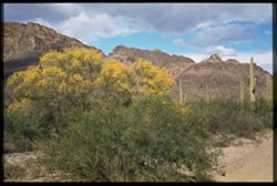
- Description:
- 50 f 11 sl
- Subject:
- Deserts, Mountains, Shrubs, Cactus, and Saguaro National Park (Ariz.)
- Series:
- 10-59
- Creator:
- Cushman, Charles W., 1896-1972
- Date Created:
- 1959-03-03
- Genre:
- Identification photographs
- Frame Number:
- 5
- County:
- Pima
- Abstract:
- Multi-branched Giant Sohuaro
- Call Number:
- P10693
- City:
- Tucson
- Country:
- United States
- State/Province:
- Arizona
- Alternate Identifier:
- 1059.5
- Persistent URL:
- http://purl.dlib.indiana.edu/iudl/archives/cushman/P10693
-
- Description:
- 100 f 8 tl
- Subject:
- Mountains, Fences, Shrubs, and Roskruge Mountains (Ariz.)
- Series:
- 9-59
- Creator:
- Cushman, Charles W., 1896-1972
- Date Created:
- 1959-02-20
- Genre:
- Landscape photographs
- Frame Number:
- 5
- Street Address:
- Tucson-Ajo Highway and Ajo Way
- County:
- Pima
- Abstract:
- Roskruge Mtns. - from Ajo road
- Call Number:
- P10656
- City:
- Tucson
- Country:
- United States
- State/Province:
- Arizona
- Alternate Identifier:
- 959.5
- Persistent URL:
- http://purl.dlib.indiana.edu/iudl/archives/cushman/P10656
-
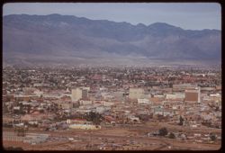
- Description:
- 100 f 6.3 tl
- Subject:
- Electric lines, Automobiles, Trees, Signs (Notices), Streets, Mountains, Buildings, Shrubs, Tucson Mountains (Ariz.), Dwellings, and Parking lots
- Series:
- 8-59
- Creator:
- Cushman, Charles W., 1896-1972
- Date Created:
- 1959-02-11
- Genre:
- Cityscape photographs
- Frame Number:
- 5
- County:
- Pima
- Abstract:
- Tucson from A Mtn.
- Call Number:
- P10619
- City:
- Tucson
- Country:
- United States
- State/Province:
- Arizona
- Alternate Identifier:
- 859.5
- Persistent URL:
- http://purl.dlib.indiana.edu/iudl/archives/cushman/P10619
-
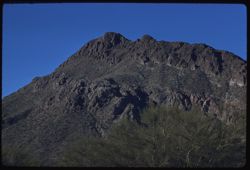
- Description:
- 100 f 8 tl
- Subject:
- Trees, Mountains, and Tucson Mountains (Ariz.)
- Series:
- 6-59
- Creator:
- Cushman, Charles W., 1896-1972
- Date Created:
- 1959-01-25
- Genre:
- Landscape photographs
- Frame Number:
- 5
- County:
- Pima
- Abstract:
- Maybe Golden Gate Mtn (?)
- Call Number:
- P10543
- City:
- Tucson
- Country:
- United States
- State/Province:
- Arizona
- Alternate Identifier:
- 659.5
- Persistent URL:
- http://purl.dlib.indiana.edu/iudl/archives/cushman/P10543
-
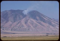
- Description:
- 100 f 6.3 tl hf
- Subject:
- Forest fires, Smoke, Plains, Mountains, and Oquirrh Mountains (Utah)
- Series:
- 16-58
- Creator:
- Cushman, Charles W., 1896-1972
- Date Created:
- 1958-08-23
- Genre:
- Landscape photographs
- Frame Number:
- 5
- Street Address:
- United States Highway 40
- Abstract:
- Forest fire high up Oquirrh same mtns.
- Call Number:
- P10131
- Country:
- United States
- State/Province:
- Utah
- Alternate Identifier:
- 1658.5
- Persistent URL:
- http://purl.dlib.indiana.edu/iudl/archives/cushman/P10131
-
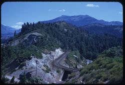
- Description:
- 100 f 5.6 tl
- Subject:
- Emigrant Gap (Calif. : Gap), Automobiles, Southern Pacific Railroad Company, Mountains, Sierra Nevada (Calif. and Nev.), Utility poles, Railroads, Roads, and...
- Series:
- 15-58
- Creator:
- Cushman, Charles W., 1896-1972
- Date Created:
- 1958-08-22
- Genre:
- Landscape photographs
- Frame Number:
- 5
- Street Address:
- United States Highway 40
- Abstract:
- Hwy 40 to SP eastward from Emigrant Gap
- Call Number:
- P10111
- Country:
- United States
- State/Province:
- California and Nevada
- Alternate Identifier:
- 1558.5
- Persistent URL:
- http://purl.dlib.indiana.edu/iudl/archives/cushman/P10111
-
- Description:
- 100 f 5.6 TL HF
- Subject:
- Rocks, Pines, Mountains, Tahoe, Lake (Calif. and Nev.), Lakes & ponds, and Firs
- Series:
- 13-58
- Creator:
- Cushman, Charles W., 1896-1972
- Date Created:
- 1958-06-19
- Genre:
- Landscape photographs
- Frame Number:
- 5
- Abstract:
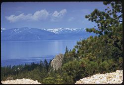
- Toward Tahoe & mtns across -
- Call Number:
- P10053
- Country:
- United States
- State/Province:
- California and Nevada
- Alternate Identifier:
- 1358.5
- Persistent URL:
- http://purl.dlib.indiana.edu/iudl/archives/cushman/P10053
-
- Description:
- 100 f 6.3 SL
- Subject:
- Grasses, Volcanic rock, Mountains, Shrubs, and Clouds
- Series:
- 11-58
- Creator:
- Cushman, Charles W., 1896-1972
- Date Created:
- 1958-06-14
- Genre:
- Landscape photographs
- Frame Number:
- 5
- Street Address:
- United States Highway 20
- County:
- Malheur
- Abstract:
- Great brown lava
- Call Number:
- P09980
- Country:
- United States
- State/Province:
- Oregon
- Alternate Identifier:
- 1158.5
- Persistent URL:
- http://purl.dlib.indiana.edu/iudl/archives/cushman/P09980
-
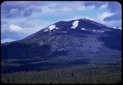
- Description:
- 100 5.6 tl
- Subject:
- Snow, Shadows, Burney Mountain (Calif.), Mountains, Clouds, Firs, and Forests
- Series:
- 10-58
- Creator:
- Cushman, Charles W., 1896-1972
- Date Created:
- 1958-06-12
- Genre:
- Landscape photographs
- Frame Number:
- 5
- County:
- Shasta
- Abstract:
- Burney Mtn.
- Call Number:
- P09943
- Country:
- United States
- State/Province:
- California
- Alternate Identifier:
- 1058.5
- Persistent URL:
- http://purl.dlib.indiana.edu/iudl/archives/cushman/P09943
-
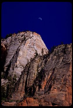
- Description:
- 100 f 8 tl
- Subject:
- Sinewava, Temple of (Utah), Cliffs, Great White Throne (Utah), Trees, Moon, Mountains, National parks & reserves, Zion National Park (Utah), and Rock for...
- Series:
- 5-58
- Creator:
- Cushman, Charles W., 1896-1972
- Date Created:
- 1958-04-26
- Genre:
- Landscape photographs
- Frame Number:
- 5
- County:
- Washington
- Abstract:
- Moon over from Sinewava
- Call Number:
- P09794
- Country:
- United States
- State/Province:
- Utah
- Alternate Identifier:
- 558.5
- Persistent URL:
- http://purl.dlib.indiana.edu/iudl/archives/cushman/P09794
-
- Description:
- 100 f 8 tl
- Subject:
- Rocks, Mesas, Mountains, and Plants
- Series:
- 4-58
- Creator:
- Cushman, Charles W., 1896-1972
- Date Created:
- 1958-04-26
- Genre:
- Landscape photographs
- Frame Number:
- 5
- County:
- Washington
- Abstract:
- Looking back toward St. George
- Call Number:
- P09757
- City:
- Saint George
- Country:
- United States
- State/Province:
- Utah
- Alternate Identifier:
- 458.5
- Persistent URL:
- http://purl.dlib.indiana.edu/iudl/archives/cushman/P09757
-
- Description:
- 100 f 6.3 tl
- Subject:
- Canyons, Grasses, Cuesta Pass (Calif.), Trees, Mountains, Shrubs, Railroad passenger cars, Passes (Landforms), Embankments, Railroads, and Southern Pacific R...
- Series:
- 14-57
- Creator:
- Cushman, Charles W., 1896-1972
- Date Created:
- 1957-09-19
- Genre:
- Landscape photographs
- Frame Number:
- 5
- County:
- San Luis Obispo
- Abstract:
- [P] View across Cuesta grade
- Call Number:
- P09504
- Country:
- United States
- State/Province:
- California
- Alternate Identifier:
- 1457.5
- Persistent URL:
- http://purl.dlib.indiana.edu/iudl/archives/cushman/P09504
-
- Description:
- 100 f 6.3 tl
- Subject:
- Shasta Lake (Calif.), Trees, Coastlines, Mountains, Lakes & ponds, and Clouds
- Series:
- 11-56
- Creator:
- Cushman, Charles W., 1896-1972
- Date Created:
- 1956-07-14
- Genre:
- Landscape photographs
- Frame Number:
- 5
- Street Address:
- United States Highway 99
- County:
- Shasta
- Abstract:
- Shasta Lake
- Call Number:
- P08903
- Country:
- United States
- State/Province:
- California
- Alternate Identifier:
- 1156.5
- Persistent URL:
- http://purl.dlib.indiana.edu/iudl/archives/cushman/P08903
-

- Description:
- 100 f 8 TL
- Subject:
- Santa Ynez Mountains (Calif.), Trees, Flowers, Meadows, Mountains, Clouds, and Santa Barbara Mission
- Series:
- 5-56
- Creator:
- Cushman, Charles W., 1896-1972
- Date Created:
- 1956-04-20
- Genre:
- Landscape photographs
- Frame Number:
- 5
- County:
- Santa Barbara
- Abstract:
- Clouds above Santa Ynez Mtns
- Call Number:
- P08679
- City:
- Santa Barbara
- Country:
- United States
- State/Province:
- California
- Alternate Identifier:
- 556.5
- Persistent URL:
- http://purl.dlib.indiana.edu/iudl/archives/cushman/P08679
-
- Description:
- 100 f 8 tl
- Subject:
- Roads, Trees, Konocti, Mount (Calif.), Mountains, Clouds, and Hills
- Series:
- 4-56
- Creator:
- Cushman, Charles W., 1896-1972
- Date Created:
- 1956-04-16
- Genre:
- Landscape photographs
- Frame Number:
- 5
- Street Address:
- Hopland-Lakeport Road
- County:
- Lake
- Abstract:
- From summit of Hopland - Lakeport rd at 75,500 miles Mt. Konocti
- Call Number:
- P08644
- City:
- Lakeport
- Country:
- United States
- State/Province:
- California
- Alternate Identifier:
- 456.5
- Persistent URL:
- http://purl.dlib.indiana.edu/iudl/archives/cushman/P08644
-
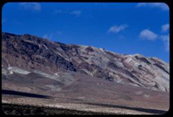
- Description:
- 100 f 8 tl
- Subject:
- Snow, Mountains, Utility poles, and Plants
- Series:
- 27-55
- Creator:
- Cushman, Charles W., 1896-1972
- Date Created:
- 1955-09-26
- Genre:
- Landscape photographs
- Frame Number:
- 5
- Street Address:
- United States Highway 395
- County:
- Mono
- Abstract:
- Fresh snow on Mtn from US 395 at 70296 near Mammoth Lakes
- Call Number:
- P08425
- City:
- Mammoth Lakes
- Country:
- United States
- State/Province:
- California
- Alternate Identifier:
- 2755.5
- Persistent URL:
- http://purl.dlib.indiana.edu/iudl/archives/cushman/P08425
-
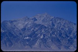
- Description:
- 100 f 8 tl
- Subject:
- Williamson, Mount (Inyo County, Calif.) and Mountains
- Series:
- 26-55
- Creator:
- Cushman, Charles W., 1896-1972
- Date Created:
- 1955-09-25
- Genre:
- Landscape photographs
- Frame Number:
- 5
- County:
- Inyo
- Abstract:
- Mt Williamson - broadside
- Call Number:
- P08388
- City:
- Independence
- Country:
- United States
- State/Province:
- California
- Alternate Identifier:
- 2655.5
- Persistent URL:
- http://purl.dlib.indiana.edu/iudl/archives/cushman/P08388
-
- Description:
- 100 f 5.6 TL
- Subject:
- Echo Summit (El Dorado County, Calif.), Mountains, Trees, Tahoe, Lake (Calif. and Nev.), and Lakes & ponds
- Series:
- 25-55
- Creator:
- Cushman, Charles W., 1896-1972
- Date Created:
- 1955-09-24
- Genre:
- Landscape photographs
- Frame Number:
- 5
- Street Address:
- United States Highway 50
- County:
- Placer
- Abstract:
- From 1/4 mi further on US 50 toward L Tahoe & [ ]
- Call Number:
- P08353
- Country:
- United States
- State/Province:
- California
- Alternate Identifier:
- 2555.5
- Persistent URL:
- http://purl.dlib.indiana.edu/iudl/archives/cushman/P08353
-
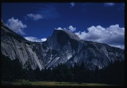
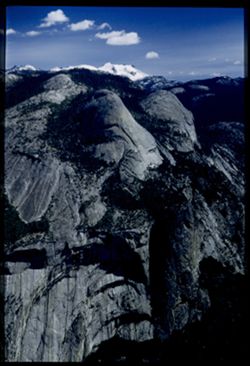
- Description:
- 100 f 8 sl 50 mm
- Subject:
- Yosemite Valley (Calif.), Valleys, Cliffs, Yosemite National Park (Calif.), Trees, Half Dome (Calif.), Mountains, National parks & reserves, Clouds, and ...
- Series:
- 22-55
- Creator:
- Cushman, Charles W., 1896-1972
- Date Created:
- 1955-07-09
- Genre:
- Landscape photographs
- Frame Number:
- 5
- County:
- Mariposa
- Abstract:
- 0 Half dome from valley floor
- Call Number:
- P08258
- Country:
- United States
- State/Province:
- California
- Physical Description:
- Image was originally mounted in a glass enclosure. Before digitization, the image was removed and placed in a Wess Plastic, Inc. brand, 2" x 2", pl...
- Alternate Identifier:
- 2255.5
- Persistent URL:
- http://purl.dlib.indiana.edu/iudl/archives/cushman/P08258
-
- Description:
- 100 f 5.6 tl
- Subject:
- Rocks, Valleys, Yosemite National Park (Calif.), Trees, Cathedral Rocks (Calif.), Half Dome (Calif.), Mountains, Rock formations, and National parks & re...
- Series:
- 21-55
- Creator:
- Cushman, Charles W., 1896-1972
- Date Created:
- 1955-07-08
- Genre:
- Landscape photographs
- Frame Number:
- 5
- County:
- Mariposa
- Abstract:
- Cathedral rocks
- Call Number:
- P08224
- Country:
- United States
- State/Province:
- California
- Alternate Identifier:
- 2155.5
- Persistent URL:
- http://purl.dlib.indiana.edu/iudl/archives/cushman/P08224
-
- Description:
- 100 f 6.3 tl
- Subject:
- Yosemite Valley (Calif.), Bridalveil Fall (Calif.), Waterfalls, Trees, Mountains, and Shrubs
- Series:
- 20-55
- Creator:
- Cushman, Charles W., 1896-1972
- Date Created:
- 1955-07-07
- Genre:
- Landscape photographs
- Frame Number:
- 5
- County:
- Mariposa
- Abstract:
- Bridal Veil Falls from tunnel view
- Call Number:
- P08189
- Country:
- United States
- State/Province:
- California
- Physical Description:
- Image was originally mounted in a glass enclosure. Before digitization, the image was removed and placed in a Wess Plastic, Inc. brand, 2" x 2", pl...
- Alternate Identifier:
- 2055.5
- Persistent URL:
- http://purl.dlib.indiana.edu/iudl/archives/cushman/P08189
-
- Description:
- 200 f 4+tl
- Subject:
- East Bay (Calif.), Vessels, Bodies of water, Twin Peaks (San Francisco County, Calif.), Trees, San Francisco-Oakland Bay Bridge (Oakland and San Francisco, C...
- Series:
- 19-55
- Creator:
- Cushman, Charles W., 1896-1972
- Date Created:
- 1955-07-02
- Genre:
- Cityscape photographs
- Frame Number:
- 5
- County:
- San Francisco
- Abstract:
- [?] Buena to the Bay Bridge Slides in separate box scratched or spotted
- Call Number:
- P08158
- City:
- San Francisco
- Country:
- United States
- State/Province:
- California
- Alternate Identifier:
- 1955.5
- Persistent URL:
- http://purl.dlib.indiana.edu/iudl/archives/cushman/P08158
-
- Description:
- 100 f 8 tl
- Subject:
- Rocks, Valleys, Mountains, Shrubs, Zabriskie Point (Calif.), Death Valley National Park (Calif. and Nev.), and Hills
- Series:
- 9-55
- Creator:
- Cushman, Charles W., 1896-1972
- Date Created:
- 1955-03-22
- Genre:
- Landscape photographs
- Frame Number:
- 5
- County:
- Inyo
- Abstract:
- Yellow fan-shaped rock vicinity of Zabriskie Pt.
- Call Number:
- P07797
- Country:
- United States
- State/Province:
- California
- Alternate Identifier:
- 955.5
- Persistent URL:
- http://purl.dlib.indiana.edu/iudl/archives/cushman/P07797
-
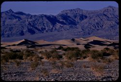
- Description:
- 100 f 8 tl
- Subject:
- Valleys, Hills, Grapevine Mountains (Calif. and Nev.), Death Valley (Calif. and Nev.), Mountains, Shrubs, Rocks, and Dunes
- Series:
- 8-55
- Creator:
- Cushman, Charles W., 1896-1972
- Date Created:
- 1955-03-21
- Genre:
- Landscape photographs
- Frame Number:
- 5
- County:
- Inyo
- Abstract:
- S Sand dunes and Grapevine Mtns. north of road a mile or 2 e. of S.P.W. SD
- Call Number:
- P07765
- City:
- Stovepipe Wells
- Country:
- United States
- State/Province:
- California
- Alternate Identifier:
- 855.5
- Persistent URL:
- http://purl.dlib.indiana.edu/iudl/archives/cushman/P07765
-
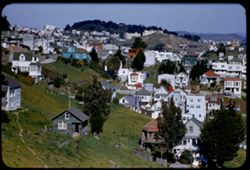
- Description:
- 200 f 4 tl
- Subject:
- Automobiles, Trees, Diamond Heights (San Francisco, Calif.), Streets, Mountains, Buildings, Trucks, Dwellings, Hills, Utility poles, Buena Vista Park (San Fr...
- Series:
- 6-55
- Creator:
- Cushman, Charles W., 1896-1972
- Date Created:
- 1955-03-14
- Genre:
- Cityscape photographs
- Frame Number:
- 5
- Street Address:
- Farnum Street
- County:
- San Francisco
- Abstract:
- Toward Buena Vista and Corona Hts.
- Call Number:
- P07707
- City:
- San Francisco
- Country:
- United States
- State/Province:
- California
- Alternate Identifier:
- 655.5
- Persistent URL:
- http://purl.dlib.indiana.edu/iudl/archives/cushman/P07707
-
- Description:
- 100 f 8 tl
- Subject:
- Hills, Mountains, Shrubs, Snow, Boulders, Rocks, Fences, Sierra Nevada (Calif. and Nev.), and Alabama Hills (Calif.)
- Series:
- 4-55
- Creator:
- Cushman, Charles W., 1896-1972
- Date Created:
- 1955-02-28
- Genre:
- Landscape photographs
- Frame Number:
- 5
- County:
- Inyo
- Abstract:
- Ala Hills & back of roof of Sierra
- Call Number:
- P07633
- Country:
- United States
- State/Province:
- California
- Alternate Identifier:
- 455.5
- Persistent URL:
- http://purl.dlib.indiana.edu/iudl/archives/cushman/P07633
-
- Description:
- 100 f 8 tl
- Subject:
- Valleys, Dantes View (Calif.), Mountains, Shrubs, Death Valley (Calif. and Nev.), and Black Mountains (Inyo County, Calif.)
- Series:
- 3-55
- Creator:
- Cushman, Charles W., 1896-1972
- Date Created:
- 1955-02-27
- Genre:
- Landscape photographs
- Frame Number:
- 5
- County:
- Inyo
- Abstract:
- East side of Black Mtns from road below Dante's View
- Call Number:
- P07598
- Country:
- United States
- State/Province:
- California
- Alternate Identifier:
- 355.5
- Persistent URL:
- http://purl.dlib.indiana.edu/iudl/archives/cushman/P07598
-
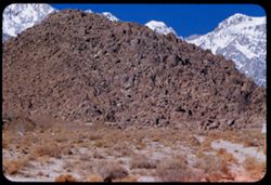
- Description:
- 50 f 11
- Subject:
- Poplars, Ranches, White Mountains (Calif. and Nev.), Trees, Owens Valley (Calif.), Mountains, Shrubs, and Lombardy poplar
- Series:
- 12-54
- Creator:
- Cushman, Charles W., 1896-1972
- Date Created:
- 1954-09-17
- Genre:
- Landscape photographs
- Frame Number:
- 5
- County:
- Esmeralda and Inyo
- Abstract:
- Ranch with rows of Lombardy poplars below backdrop of White Mtns.
- Call Number:
- P07395
- Country:
- United States
- State/Province:
- California and Nevada
- Physical Description:
- masked.
- Alternate Identifier:
- 1254.5
- Persistent URL:
- http://purl.dlib.indiana.edu/iudl/archives/cushman/P07395
-
- Description:
- 50 f 9
- Subject:
- Flowers, Hills, Roads, Mountains, Shrubs, Sierra Nevada (Calif. and Nev.), Trees, Rocks, and Grasses
- Series:
- 11-54
- Creator:
- Cushman, Charles W., 1896-1972
- Date Created:
- 1954-09-17
- Genre:
- Landscape photographs
- Frame Number:
- 5
- Street Address:
- Sabrina Lake Road
- County:
- Inyo
- Abstract:
- High Sierra seen from Sabrina Lake road SW of Bishop.
- Call Number:
- P07374
- City:
- Bishop
- Country:
- United States
- State/Province:
- California
- Alternate Identifier:
- 1154.5
- Persistent URL:
- http://purl.dlib.indiana.edu/iudl/archives/cushman/P07374
-
- Description:
- 50 f 8
- Subject:
- Rocks, Stanislaus River Canyon (Calif.), Grasses, Trees, Buttes, Mountains, Shrubs, and Rock formations
- Series:
- 9-54
- Creator:
- Cushman, Charles W., 1896-1972
- Date Created:
- 1954-09-15
- Genre:
- Landscape photographs
- Frame Number:
- 5
- Street Address:
- California State Highway 108
- County:
- Tuolumne
- Abstract:
- Looking up at granite ridge from Hwy 108 far below. 5:30 PM.
- Call Number:
- P07316
- City:
- Dardanelle
- Country:
- United States
- State/Province:
- California
- Alternate Identifier:
- 954.5
- Persistent URL:
- http://purl.dlib.indiana.edu/iudl/archives/cushman/P07316
-
- Description:
- 50 f 8
- Subject:
- Lakes & ponds, Britton, Lake (Calif.), Bodies of water, Mountains, Shrubs, Reservoirs, and Trees
- Series:
- 7-54
- Creator:
- Cushman, Charles W., 1896-1972
- Date Created:
- 1954-08-21
- Genre:
- Landscape photographs
- Frame Number:
- 5
- Street Address:
- California State Highway 89
- County:
- Shasta
- Abstract:
- Lake Britten from Calif Hwy 89.
- Call Number:
- P07260
- City:
- Cassel
- Country:
- United States
- State/Province:
- California
- Alternate Identifier:
- 754.5
- Persistent URL:
- http://purl.dlib.indiana.edu/iudl/archives/cushman/P07260
-
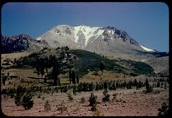
- Description:
- 50 f 10
- Subject:
- Lava domes, Hills, Lassen Peak (Calif.), Lassen Volcanic National Park (Calif.), Volcanic domes, Mountains, Shrubs, Snow, Trees, Rocks, and Volcanoes
- Series:
- 5-54
- Creator:
- Cushman, Charles W., 1896-1972
- Date Created:
- 1954-08-19
- Genre:
- Landscape photographs
- Frame Number:
- 5
- County:
- Shasta
- Abstract:
- Broadside view of Lassen Pk across broad dry rash
- Call Number:
- P07201
- Country:
- United States
- State/Province:
- California
- Physical Description:
- Anscochrome film.
- Alternate Identifier:
- 554.5
- Persistent URL:
- http://purl.dlib.indiana.edu/iudl/archives/cushman/P07201
-
- Description:
- 50 f 9
- Subject:
- Straw flowers, Grasses, Trees, Flowers, Meadows, Mountains, Shrubs, and Half Moon Bay (Calif.)
- Series:
- 4-54
- Creator:
- Cushman, Charles W., 1896-1972
- Date Created:
- 1954-07-22
- Genre:
- Landscape photographs
- Frame Number:
- 5
- Street Address:
- California State Highway 1
- County:
- San Mateo
- Abstract:
- Field of straw flowers with mtns in distance - along Hwy 1near Half Moon Bay
- Call Number:
- P07179
- Country:
- United States
- State/Province:
- California
- Physical Description:
- Anscochrome film.
- Alternate Identifier:
- 454.5
- Persistent URL:
- http://purl.dlib.indiana.edu/iudl/archives/cushman/P07179
-
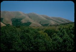
- Description:
- 50 f 9
- Subject:
- Grasses, Grazing, Farms, Trees, Cattle, Mountains, Shrubs, Cows, Black Mountain (Marin County, Calif.), and Hills
- Series:
- 2-54
- Creator:
- Cushman, Charles W., 1896-1972
- Date Created:
- 1954-05-21
- Genre:
- Landscape photographs
- Frame Number:
- 5
- County:
- Marin
- Abstract:
- Cows graze below Black Mtn. - Marin county
- Call Number:
- P07136
- Country:
- United States
- State/Province:
- California
- Alternate Identifier:
- 254.5
- Persistent URL:
- http://purl.dlib.indiana.edu/iudl/archives/cushman/P07136
-
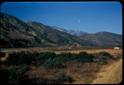
- Description:
- 50 f 5.6 POLA
- Subject:
- Grasses, Trees, Mountains, Passes (Landforms), Cajon Pass (Calif.), and Hills
- Series:
- 16-53
- Creator:
- Cushman, Charles W., 1896-1972
- Date Created:
- 1953-11-23
- Genre:
- Landscape photographs
- Frame Number:
- 5
- Street Address:
- United States Highway 66
- County:
- San Bernardino
- Abstract:
- Cajon Pass
- Call Number:
- P07077
- Country:
- United States
- State/Province:
- California
- Alternate Identifier:
- 1653.5
- Persistent URL:
- http://purl.dlib.indiana.edu/iudl/archives/cushman/P07077
-
- Description:
- 50 f 2.8
- Subject:
- Traffic signs & signals, Roads, Mountains, Snow, Trees, Rocks, Railings, Grasses, and Mingus Mountain (Ariz.)
- Series:
- 15-53
- Creator:
- Cushman, Charles W., 1896-1972
- Date Created:
- 1953-11-20
- Genre:
- Landscape photographs
- Frame Number:
- 5
- Street Address:
- United States Highway 89A
- County:
- Yavapai
- Abstract:
- US 89A through Mingus Mtns.
- Call Number:
- P07039
- Country:
- United States
- State/Province:
- Arizona
- Alternate Identifier:
- 1553.5
- Persistent URL:
- http://purl.dlib.indiana.edu/iudl/archives/cushman/P07039
-
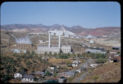
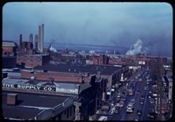
- Description:
- 50 f 9
- Subject:
- Houses, Trees, Smoke, Streets, Miami Copper Co. (Miami, Ariz.), Cities & towns, Buildings, Hills, Smokestacks, Factories, Copper industry, Copper mining,...
- Series:
- 14-53
- Creator:
- Cushman, Charles W., 1896-1972
- Date Created:
- 1953-11-19
- Genre:
- Cityscape photographs and Architectural photographs
- Frame Number:
- 5
- County:
- Gila
- Abstract:
- Miami Copper Co plant Miami-
- Call Number:
- P07001
- City:
- Miami
- Country:
- United States
- State/Province:
- Arizona
- Alternate Identifier:
- 1453.5
- Persistent URL:
- http://purl.dlib.indiana.edu/iudl/archives/cushman/P07001
-
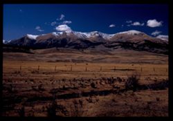
- Description:
- 50 f 9 Pola
- Subject:
- Snow, Grasses, Grazing, Meadows, Cattle, Mountains, Fences, Shrubs, Clouds, Hills, and Elbert, Mount (Colo.)
- Series:
- 11-53
- Creator:
- Cushman, Charles W., 1896-1972
- Date Created:
- 1953-10-15
- Genre:
- Landscape photographs
- Frame Number:
- 5
- County:
- Lake
- Abstract:
- Mt. Elbert from east
- Call Number:
- P06884
- City:
- Leadville
- Country:
- United States
- State/Province:
- Colorado
- Physical Description:
- Image was originally mounted in a glass enclosure. Before digitization, the image was removed and placed in a Wess Plastic, Inc. brand, 2" x 2", pl...
- Alternate Identifier:
- 1153.5
- Persistent URL:
- http://purl.dlib.indiana.edu/iudl/archives/cushman/P06884
-
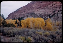
- Description:
- 50 f 5.6
- Subject:
- Erosion, Trees, Mountains, Shrubs, and Autumn
- Series:
- 10-53
- Creator:
- Cushman, Charles W., 1896-1972
- Date Created:
- 1953-10-13
- Genre:
- Landscape photographs
- Frame Number:
- 5
- Street Address:
- United States Highway 6
- County:
- Eagle
- Abstract:
- Yellow trees & red Mountain from US 6 east of Eagle
- Call Number:
- P06845
- City:
- Eagle
- Country:
- United States
- State/Province:
- Colorado
- Alternate Identifier:
- 1053.5
- Persistent URL:
- http://purl.dlib.indiana.edu/iudl/archives/cushman/P06845
-
- Description:
- 50 f 11
- Subject:
- Rocks, Grasses, Dirt, Mountains, Shrubs, Wood poles, and Rock formations
- Series:
- 9-53
- Creator:
- Cushman, Charles W., 1896-1972
- Date Created:
- 1953-10-10
- Genre:
- Landscape photographs
- Frame Number:
- 5
- Street Address:
- United States Highway 40
- County:
- Elko
- Abstract:
- Strange rock shapes US 40 w. of Elko.
- Call Number:
- P06806
- City:
- Elko
- Country:
- United States
- State/Province:
- Nevada
- Alternate Identifier:
- 953.5
- Persistent URL:
- http://purl.dlib.indiana.edu/iudl/archives/cushman/P06806
-
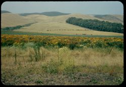
- Description:
- 25 f 7 Pola
- Subject:
- Grasses, Farms, Trees, Meadows, Tree limbs, Croplands, Fences, Sonoma Mountain (Calif.), Clouds, Hills, and Mountains
- Series:
- 8-53
- Creator:
- Cushman, Charles W., 1896-1972
- Date Created:
- 1953-08-30
- Genre:
- Landscape photographs
- Frame Number:
- 5
- County:
- Sonoma
- Abstract:
- View north from Sonoma Mtn road.
- Call Number:
- P06768
- Country:
- United States
- State/Province:
- California
- Alternate Identifier:
- 853.5
- Persistent URL:
- http://purl.dlib.indiana.edu/iudl/archives/cushman/P06768
-
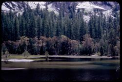
- Description:
- 50 f 5.6
- Subject:
- Yosemite Valley (Calif.), Valleys, Yosemite National Park (Calif.), Mirror Lake (Mariposa County, Calif.), Mountains, Shrubs, Lakes & ponds, Trees, and N...
- Series:
- 6-53
- Creator:
- Cushman, Charles W., 1896-1972
- Date Created:
- 1953-05-14
- Genre:
- Landscape photographs
- Frame Number:
- 5
- County:
- Mariposa
- Abstract:
- Mirror Lake
- Call Number:
- P06693
- Country:
- United States
- State/Province:
- California
- Alternate Identifier:
- 653.5
- Persistent URL:
- http://purl.dlib.indiana.edu/iudl/archives/cushman/P06693
-
- Description:
- 50 f 5.6
- Subject:
- Snow, Yosemite Valley (Calif.), Yosemite National Park (Calif.), Mountains, Glacier Point (Calif.), Clouds, and National parks & reserves
- Series:
- 5-53
- Creator:
- Cushman, Charles W., 1896-1972
- Date Created:
- 1953-05-13
- Genre:
- Landscape photographs
- Frame Number:
- 5
- County:
- Mariposa
- Abstract:
- NE across valley from GP. [P]
- Call Number:
- P06655
- Country:
- United States
- State/Province:
- California
- Physical Description:
- Image was originally mounted in a glass enclosure. Before digitization, the image was removed and placed in a Wess Plastic, Inc. brand, 2" x 2", pl...
- Alternate Identifier:
- 553.5
- Persistent URL:
- http://purl.dlib.indiana.edu/iudl/archives/cushman/P06655
-
- Description:
- 25 f 6.3 Pola
- Subject:
- Deserts, Cliffs, Colorado National Monument (Colo.), Mesas, Buttes, Mountains, Shrubs, Clouds, Roads, Trees, and National parks & reserves
- Series:
- 26-52
- Creator:
- Cushman, Charles W., 1896-1972
- Date Created:
- 1952-11-03
- Genre:
- Landscape photographs
- Frame Number:
- 5
- County:
- Mesa
- Abstract:
- View over Grnd Juctn.
- Call Number:
- P06412
- City:
- Grand Junction
- Country:
- United States
- State/Province:
- Colorado
- Alternate Identifier:
- 2652.5
- Persistent URL:
- http://purl.dlib.indiana.edu/iudl/archives/cushman/P06412
-
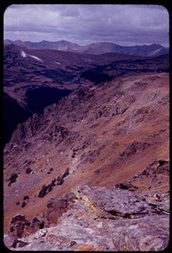
- Description:
- 50 f 8
- Subject:
- National parks & reserves, Rocky Mountains, Passes (Landforms), Rocky Mountain National Park (Colo.), Forests, Cliffs, Mountains, Shrubs, Trees, Rocks, a...
- Series:
- 25-52
- Creator:
- Cushman, Charles W., 1896-1972
- Date Created:
- 1952-11-01
- Genre:
- Landscape photographs
- Frame Number:
- 5
- Abstract:
- View west from pass of 12,110 ft elev.
- Call Number:
- P06374
- Country:
- United States
- State/Province:
- Colorado
- Alternate Identifier:
- 2552.5
- Persistent URL:
- http://purl.dlib.indiana.edu/iudl/archives/cushman/P06374
-
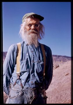
- Description:
- 1/50 f 6.3 or f 5.6
- Subject:
- Men, Mustaches, Mountains, Hills, Hats, Beards, Eyeglasses, and Travelers
- Series:
- 27-52
- Creator:
- Cushman, Charles W., 1896-1972
- Date Created:
- 1952-11-04
- Genre:
- Portraits
- Frame Number:
- 5
- County:
- Grand
- Persons Pictured:
- Holley, Jack W.
- Abstract:
- 1 to 7 - at Jack Holley's abode.
- Call Number:
- P06450
- City:
- Moab
- Country:
- United States
- State/Province:
- Utah
- Physical Description:
- Image was originally mounted in a glass enclosure. Before digitization, the image was removed and placed in a Wess Plastic, Inc. brand, 2" x 2", pl...
- Alternate Identifier:
- 2752.5
- Persistent URL:
- http://purl.dlib.indiana.edu/iudl/archives/cushman/P06450
-

- Description:
- 25 f 6 POLA
- Subject:
- Rocks, Roads, Parks, Boulders, Shadows, Buttes, Mountains, Buildings, Rock formations, Clouds, Red Rocks Park (Jefferson County, Colo.), Hills, and Cliffs
- Series:
- 24-52
- Creator:
- Cushman, Charles W., 1896-1972
- Date Created:
- 1952-10-30
- Genre:
- Landscape photographs
- Frame Number:
- 5
- County:
- Jefferson
- Abstract:
- Red Rock Park west of Denver
- Call Number:
- P06336
- City:
- Morrison
- Country:
- United States
- State/Province:
- Colorado
- Alternate Identifier:
- 2452.5
- Persistent URL:
- http://purl.dlib.indiana.edu/iudl/archives/cushman/P06336
-
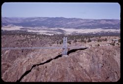
- Description:
- 25 f 9
- Subject:
- Trucks, Cliffs, Mountains, Buildings, Towers, Suspension bridges, Arkansas River, Royal Gorge (Colo.), Canyons, and Shadows
- Series:
- 23-52
- Creator:
- Cushman, Charles W., 1896-1972
- Date Created:
- 1952-10-28
- Genre:
- Landscape photographs
- Frame Number:
- 5
- County:
- Fremont
- Abstract:
- View across north tower of bridge-country on left bank of Ark river
- Call Number:
- P06297
- Country:
- United States
- State/Province:
- Colorado
- Alternate Identifier:
- 2352.5
- Persistent URL:
- http://purl.dlib.indiana.edu/iudl/archives/cushman/P06297
-
- Description:
- 25 f 16
- Subject:
- Boundaries, Cliffs, Trees, Mountains, Shrubs, and Mesas
- Series:
- 18-52
- Creator:
- Cushman, Charles W., 1896-1972
- Date Created:
- 1952-04-13
- Genre:
- Landscape photographs
- Frame Number:
- 5
- Street Address:
- United States Highway 66
- Abstract:
- Pink mtns near NM-Ariz. line - on 66.
- Call Number:
- P06136
- Country:
- United States
- State/Province:
- Arizona and New Mexico
- Alternate Identifier:
- 1852.5
- Persistent URL:
- http://purl.dlib.indiana.edu/iudl/archives/cushman/P06136
-
- Description:
- 50 f 6.3 Pola
- Subject:
- Deserts, Valleys, Mesas, Mountains, Shrubs, Hills, and Painted Desert (Ariz.)
- Series:
- 17-52
- Creator:
- Cushman, Charles W., 1896-1972
- Date Created:
- 1952-04-12
- Genre:
- Landscape photographs
- Frame Number:
- 5
- Street Address:
- United States Highway 66
- County:
- Navajo and Coconimo
- Abstract:
- Same
- Call Number:
- P06099
- City:
- Holbrook
- Country:
- United States
- State/Province:
- Arizona
- Alternate Identifier:
- 1752.5
- Persistent URL:
- http://purl.dlib.indiana.edu/iudl/archives/cushman/P06099
-
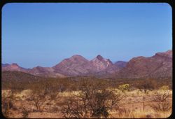
- Description:
- 25 f 13
- Subject:
- Rocks, Valleys, Panamint Range (Calif.), Argus Range (Calif.), Boulders, Mountains, Shrubs, Panamint Valley (Calif.), Canyons, and Cliffs
- Series:
- 15-52
- Creator:
- Cushman, Charles W., 1896-1972
- Date Created:
- 1952-04-08
- Genre:
- Landscape photographs
- Frame Number:
- 5
- County:
- Inyo
- Abstract:
- Flatbed of Panamint Valley from same pt. A gap in Argus Range.
- Call Number:
- P06026
- Country:
- United States
- State/Province:
- California
- Alternate Identifier:
- 1552.5
- Persistent URL:
- http://purl.dlib.indiana.edu/iudl/archives/cushman/P06026
-
- Description:
- 25 f 5.6 pola
- Subject:
- Bays (Bodies of water), Mountains, Clouds, Islands, San Francisco Bay (Calif.), and Cities & towns
- Series:
- 10-52
- Creator:
- Cushman, Charles W., 1896-1972
- Date Created:
- 1952-03-11
- Genre:
- Cityscape photographs
- Frame Number:
- 5
- Street Address:
- Grizzly Peak Drive
- County:
- Alameda and San Francisco
- Abstract:
- SF to Bay from Grizzly Pk Drive
- Call Number:
- P05841
- City:
- Oakland and San Francisco
- Country:
- United States
- State/Province:
- California
- Physical Description:
- physical matter on slide.
- Alternate Identifier:
- 1052.5
- Persistent URL:
- http://purl.dlib.indiana.edu/iudl/archives/cushman/P05841
-
- Description:
- 50 f 5.6 Pola
- Subject:
- Bays (Bodies of water), Seas, Black Mountain Lookout (San Luis Obispo County, Calif.), Trees, Coastlines, Pacific Ocean, Black Mountain (San Luis Obispo Coun...
- Series:
- 9-52
- Creator:
- Cushman, Charles W., 1896-1972
- Date Created:
- 1952-03-02
- Genre:
- Landscape photographs
- Frame Number:
- 5
- County:
- San Luis Obispo
- Abstract:
- From Black Mtn Lookout - view up coast of Estero Bay
- Call Number:
- P05803
- City:
- Morro Bay
- Country:
- United States
- State/Province:
- California
- Alternate Identifier:
- 952.5
- Persistent URL:
- http://purl.dlib.indiana.edu/iudl/archives/cushman/P05803
-
- Description:
- 25 f 6.3 Pola
- Subject:
- Houses, Automobiles, Roads, Mountains, Shrubs, Trees, and Buildings
- Series:
- 8-52
- Creator:
- Cushman, Charles W., 1896-1972
- Date Created:
- 1952-02-27
- Genre:
- Landscape photographs
- Frame Number:
- 5
- Street Address:
- Pacific Palisades and Sunset Boulevard
- County:
- Los Angeles
- Abstract:
- Mtns north of Pacific Palisades from Sunset Blvd.
- Call Number:
- P05764
- City:
- Los Angeles
- Country:
- United States
- State/Province:
- California
- Alternate Identifier:
- 852.5
- Persistent URL:
- http://purl.dlib.indiana.edu/iudl/archives/cushman/P05764
-
- Description:
- 25 f 12
- Subject:
- Deserts, Cactus, Mountains, National parks & reserves, Saguaro, Saguaro National Park (Ariz.), Women, and Shrubs
- Series:
- 3-52
- Creator:
- Cushman, Charles W., 1896-1972
- Date Created:
- 1952-01-15
- Genre:
- Portraits and Identification photographs
- Frame Number:
- 5
- County:
- Pima
- Persons Pictured:
- Cushman, Jean
- Abstract:
- Jean look at tall sahuaro.
- Call Number:
- P05574
- City:
- Tucson
- Country:
- United States
- State/Province:
- Arizona
- Alternate Identifier:
- 352.5
- Persistent URL:
- http://purl.dlib.indiana.edu/iudl/archives/cushman/P05574
-
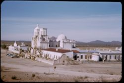
- Description:
- 25 f 11
- Subject:
- Walls, Bell towers, Missions, Automobiles, Curtain walls, Mountains, Shrubs, Mission San Xavier del Bac (Tucson, Ariz.), Domes, Stone walls, Towers, and Miss...
- Series:
- 2-52
- Creator:
- Cushman, Charles W., 1896-1972
- Date Created:
- 1952-01-05
- Genre:
- Architectural photographs
- Frame Number:
- 5
- County:
- Pima
- Abstract:
- San Xavier from hill at east.
- Call Number:
- P05535
- City:
- Tucson
- Country:
- United States
- State/Province:
- Arizona
- Alternate Identifier:
- 252.5
- Persistent URL:
- http://purl.dlib.indiana.edu/iudl/archives/cushman/P05535
-
- Description:
- 25 f 9
- Subject:
- Plains, Hills, Mountains, Shrubs, Sawtooth Mountain (Tex.), and Davis Mountains State Park (Tex.)
- Series:
- 17-51
- Creator:
- Cushman, Charles W., 1896-1972
- Date Created:
- 1951-12-29
- Genre:
- Landscape photographs
- Frame Number:
- 5
- Street Address:
- Texas State Highway 166 and Loop Texas State Highway 166
- County:
- Jeff Davis
- Abstract:
- Sawtooth Mtn. from SW.
- Call Number:
- P05462
- Country:
- United States
- State/Province:
- Texas
- Alternate Identifier:
- 1751.5
- Persistent URL:
- http://purl.dlib.indiana.edu/iudl/archives/cushman/P05462
-
- Description:
- 25 f 11
- Subject:
- Noon, National parks & reserves, Pulliam Peak (Tex.), Canyons, Valleys, Hills, Cliffs, Big Bend National Park (Tex.), Mountains, Shrubs, Trees, Basin (Bi...
- Series:
- 16-51
- Creator:
- Cushman, Charles W., 1896-1972
- Date Created:
- 1951-12-27
- Genre:
- Landscape photographs
- Frame Number:
- 5
- County:
- Brewster
- Abstract:
- Great bold front of Pulliam Pk. From Green gulch from south
- Call Number:
- P05424
- Country:
- United States
- State/Province:
- Texas
- Alternate Identifier:
- 1651.5
- Persistent URL:
- http://purl.dlib.indiana.edu/iudl/archives/cushman/P05424
-
- Subject:
- Snow, Automobiles, Trees, Smoke, Roofs, Streets, Mountains, Buildings, Facilities, Smokestacks, Signs (Notices), and Sidewalks
- Series:
- 1-41
- Creator:
- Cushman, Charles W., 1896-1972
- Date Created:
- 1941-02-01
- Genre:
- Cityscape photographs
- Frame Number:
- 5
- County:
- Dauphin
- Abstract:
- Factory + Mill smoke in Harrisburg's valley.
- Call Number:
- P02175
- City:
- Harrisburg
- Country:
- United States
- State/Province:
- Pennsylvania
- Alternate Identifier:
- 141.5
- Persistent URL:
- http://purl.dlib.indiana.edu/iudl/archives/cushman/P02175
-
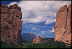
- Subject:
- Pikes Peak (Colo.), Garden of the Gods (Colorado Springs, Colo.), Shrubs, Trees, Shadows, Clouds, Mountains, and Rock formations
- Series:
- 14-40
- Creator:
- Cushman, Charles W., 1896-1972
- Date Created:
- 1940-07-19
- Genre:
- Landscape photographs
- Frame Number:
- 5
- County:
- El Paso
- Abstract:
- Looking through THE GATE- Garden of the Gods- Pike's Peak in distance, with more sunlight.
- Call Number:
- P02023
- City:
- Colorado Springs
- Country:
- United States
- State/Province:
- Colorado
- Physical Description:
- Image was originally mounted in a glass enclosure. Before digitization, the image was removed and placed in a Wess Plastic, Inc. brand, 2" x 2", pl...
- Alternate Identifier:
- 1440.5
- Persistent URL:
- http://purl.dlib.indiana.edu/iudl/archives/cushman/P02023
-
- Subject:
- National parks & reserves, Bryce Natural Bridge (Utah), Canyons, Bryce Canyon National Park (Utah), Cliffs, Mountains, Bryce Canyon (Utah : Valley), Shru...
- Series:
- 12-40
- Creator:
- Cushman, Charles W., 1896-1972
- Date Created:
- 1940-07-12
- Genre:
- Landscape photographs
- Frame Number:
- 5
- County:
- Garfield
- Abstract:
- Tall rock spire near Natural Bridge
- Call Number:
- P01984
- Country:
- United States
- State/Province:
- Utah
- Physical Description:
- Image was originally mounted in a glass enclosure. Before digitization, the image was removed and placed in a Wess Plastic, Inc. brand, 2" x 2", pl...
- Alternate Identifier:
- 1240.5
- Persistent URL:
- http://purl.dlib.indiana.edu/iudl/archives/cushman/P01984
-
- Subject:
- Rocks, Cliffs, Trees, Virgin River, Mountains, Shrubs, Zion National Park (Utah), Clouds, Zion Canyon (Utah), Rivers, and National parks & reserves
- Series:
- 11-40
- Creator:
- Cushman, Charles W., 1896-1972
- Date Created:
- 1940-07-11/1940-07-12
- Genre:
- Landscape photographs
- Frame Number:
- 5
- County:
- Washington
- Abstract:
- Looking up the Virgin river
- Call Number:
- P01965
- Country:
- United States
- State/Province:
- Utah
- Physical Description:
- Image was originally mounted in a glass enclosure. Before digitization, the image was removed and placed in a Wess Plastic, Inc. brand, 2" x 2", pl...
- Alternate Identifier:
- 1140.5
- Persistent URL:
- http://purl.dlib.indiana.edu/iudl/archives/cushman/P01965
-
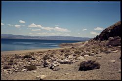
- Subject:
- Lakes & ponds, Mountains, Dirt roads, Shrubs, Rocks, Coastlines, Clouds, and Walker Lake
- Series:
- 10-40
- Creator:
- Cushman, Charles W., 1896-1972
- Date Created:
- 1940-07-09
- Genre:
- Landscape photographs
- Frame Number:
- 5
- County:
- Mineral
- Call Number:
- P01927
- Country:
- United States
- State/Province:
- Nevada
- Physical Description:
- Image was originally mounted in a glass enclosure. Before digitization, the image was removed and placed in a Wess Plastic, Inc. brand, 2" x 2", pl...
- Alternate Identifier:
- 1040.5
- Persistent URL:
- http://purl.dlib.indiana.edu/iudl/archives/cushman/P01927
-
- Subject:
- Cactus, Mountains, Shrubs, Tucson Mountains (Ariz.), Saguaro, and Clouds
- Series:
- 5-40
- Creator:
- Cushman, Charles W., 1896-1972
- Date Created:
- 1940-05-01
- Genre:
- Identification photographs
- Frame Number:
- 5
- County:
- Pima
- Abstract:
- Giant Sahuaro in bloom- in Tucson Mtn. Foothills
- Call Number:
- P01813
- Country:
- United States
- State/Province:
- Arizona
- Physical Description:
- Image was originally mounted in a glass enclosure. Before digitization, the image was removed and placed in a Wess Plastic, Inc. brand, 2" x 2", pl...
- Alternate Identifier:
- 540.5
- Persistent URL:
- http://purl.dlib.indiana.edu/iudl/archives/cushman/P01813
-
- Subject:
- Palo verde trees, Parks, Cactus, Trails & paths, Flowers, Mountains, Shrubs, Clouds, and Tucson Mountain Park (Ariz.)
- Series:
- 4-40
- Creator:
- Cushman, Charles W., 1896-1972
- Date Created:
- 1940-04-01
- Genre:
- Identification photographs
- Frame Number:
- 5
- County:
- Pima
- Abstract:
- Palo Verde in flower. Tucson Mtn. Park
- Call Number:
- P01793
- Country:
- United States
- State/Province:
- Arizona
- Physical Description:
- Image was originally mounted in a glass enclosure. Before digitization, the image was removed and placed in a Wess Plastic, Inc. brand, 2" x 2", pl...
- Alternate Identifier:
- 440.5
- Persistent URL:
- http://purl.dlib.indiana.edu/iudl/archives/cushman/P01793
-
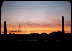
- Subject:
- Electric lines, Roads, Cactus, Mountains, Shrubs, Tucson Mountains (Ariz.), and Sunrises & sunsets
- Series:
- 2-40
- Creator:
- Cushman, Charles W., 1896-1972
- Date Created:
- 1940-02-01
- Genre:
- Landscape photographs
- Frame Number:
- 5
- Street Address:
- Nagabo Road
- County:
- Pima
- Abstract:
- Sunset sky from Nagabo road
- Call Number:
- P01760
- Country:
- United States
- State/Province:
- Arizona
- Alternate Identifier:
- 240.5
- Persistent URL:
- http://purl.dlib.indiana.edu/iudl/archives/cushman/P01760
-
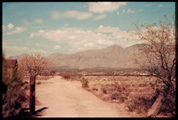
- Subject:
- Mountains, Dirt roads, Shrubs, Santa Catalina Mountains (Ariz.), Trees, Clouds, and Dwellings
- Series:
- 1-40
- Creator:
- Cushman, Charles W., 1896-1972
- Date Created:
- 1940-02-01
- Genre:
- Landscape photographs
- Frame Number:
- 5
- County:
- Pima
- Abstract:
- Santa Catalina Mtns.
- Call Number:
- P01742
- City:
- Tucson
- Country:
- United States
- State/Province:
- Arizona
- Physical Description:
- Image was originally mounted in a glass enclosure. Before digitization, the image was removed and placed in a Wess Plastic, Inc. brand, 2" x 2", pl...
- Alternate Identifier:
- 140.5
- Persistent URL:
- http://purl.dlib.indiana.edu/iudl/archives/cushman/P01742
-
- Subject:
- Deserts, Flowers, Mountains, Shrubs, Trees, Rocks, and Cerbat Mountains (Ariz.)
- Series:
- 10-39
- Creator:
- Cushman, Charles W., 1896-1972
- Date Created:
- 1939-12-01
- Genre:
- Landscape photographs
- Frame Number:
- 5
- County:
- Mohave
- Abstract:
- T-5: Cerbot Mtns behind desert flowers.
- Call Number:
- P01721
- Country:
- United States
- State/Province:
- Arizona
- Physical Description:
- some dye fading. Image was originally mounted in a glass enclosure. Before digitization, the image was removed and placed in a Wess Plastic, Inc. brand, 2&qu...
- Alternate Identifier:
- 1039.5
- Persistent URL:
- http://purl.dlib.indiana.edu/iudl/archives/cushman/P01721
-
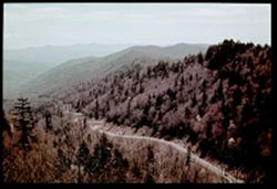
- Description:
- 1/25 f 9
- Subject:
- Roads, Fog, Trees, Newfound Gap (N.C. and Tenn.), Mountains, Shrubs, Great Smoky Mountains (N.C. and Tenn.), and Automobiles
- Series:
- 5-39
- Creator:
- Cushman, Charles W., 1896-1972
- Date Created:
- 1939-05-01
- Genre:
- Landscape photographs
- Frame Number:
- 5
- Abstract:
- N-5= Looking east from Newfound Gap.
- Call Number:
- P01632
- Country:
- United States
- State/Province:
- Tennessee and North Carolina
- Physical Description:
- Color corrected: magenta cast [fading of yellow dye]. Image was originally mounted in a glass enclosure. Before digitization, the image was removed and place...
- Alternate Identifier:
- 539.5
- Persistent URL:
- http://purl.dlib.indiana.edu/iudl/archives/cushman/P01632
-
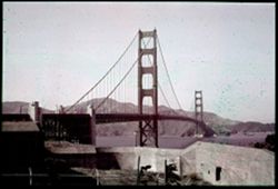
- Subject:
- Walls, Channels, Golden Gate Bridge (San Francisco, Calif.), Suspension bridges, Trees, Mountains, Fences, Shrubs, and Utility poles
- Series:
- 1-38
- Creator:
- Cushman, Charles W., 1896-1972
- Date Created:
- 1938-09-03
- Genre:
- Architectural photographs
- Frame Number:
- 5
- County:
- San Francisco
- Abstract:
- A-5 = G.G. bridge from south end.
- Call Number:
- P01411
- City:
- San Francisco
- Country:
- United States
- State/Province:
- California
- Physical Description:
- Color corrected: magenta cast [fading of yellow dye]. Image was originally mounted in a glass enclosure. Before digitization, the image was removed and place...
- Alternate Identifier:
- 138.5
- Persistent URL:
- http://purl.dlib.indiana.edu/iudl/archives/cushman/P01411