
Search Constraints
You searched for:
Campus
IUB
Remove constraint Campus: IUB
Frame Number
8
Remove constraint Frame Number: 8
Subject
Mountains
Remove constraint Subject: Mountains
State/Province
California
Remove constraint State/Province: California
1 - 39 of 39
Search Results
-
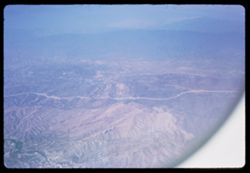
- Subject:
- Valleys, Mountains, Air travel, and Hills
- Series:
- 1-65
- Creator:
- Cushman, Charles W., 1896-1972
- Date Created:
- 1965-03-30
- Genre:
- Aerial photographs and Landscape photographs
- Frame Number:
- 8
- Call Number:
- P13872
- Country:
- United States
- State/Province:
- California
- Alternate Identifier:
- 165.8
- Persistent URL:
- http://purl.dlib.indiana.edu/iudl/archives/cushman/P13872
- Holding Location:
- Bloomington - University Archives
Wells Library E460
1320 E 10th St.
Bloomington, IN 47405
Contact at archives@indiana.edu, 812-855-1127
-
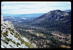
- Description:
- 100 f 5.6 SL
- Subject:
- Rocks, Valleys, Echo Summit (El Dorado County, Calif.), Trees, Mountains, Tahoe, Lake (Calif. and Nev.), Lakes & ponds, Sierra Nevada (Calif. and Nev.), ...
- Series:
- 3-62
- Creator:
- Cushman, Charles W., 1896-1972
- Date Created:
- 1962-09-28
- Genre:
- Landscape photographs
- Frame Number:
- 8
- Abstract:
- Toward right.
- Call Number:
- P12706
- Country:
- United States
- State/Province:
- California
- Alternate Identifier:
- 362.8
- Persistent URL:
- http://purl.dlib.indiana.edu/iudl/archives/cushman/P12706
- Holding Location:
- Bloomington - University Archives
Wells Library E460
1320 E 10th St.
Bloomington, IN 47405
Contact at archives@indiana.edu, 812-855-1127
-
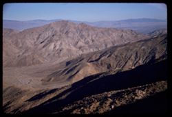
- Description:
- 50 f 11 haze filter
- Subject:
- Valleys, San Jacinto Mountains (Calif.), Hills, Coachella Valley (Calif.), and Mountains
- Series:
- 24-61
- Creator:
- Cushman, Charles W., 1896-1972
- Date Created:
- 1961-12-27
- Genre:
- Landscape photographs
- Frame Number:
- 8
- Street Address:
- California State Highway 74
- County:
- Riverside
- Abstract:
- Looking down into Coachella Valley from ht of rd. 74
- Call Number:
- P12574
- Country:
- United States
- State/Province:
- California
- Alternate Identifier:
- 2461.8
- Persistent URL:
- http://purl.dlib.indiana.edu/iudl/archives/cushman/P12574
- Holding Location:
- Bloomington - University Archives
Wells Library E460
1320 E 10th St.
Bloomington, IN 47405
Contact at archives@indiana.edu, 812-855-1127
-
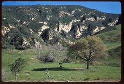
- Description:
- 50 f 8
- Subject:
- Grazing, Trees, Meadows, Livestock, Mountains, Hills, and Cattle
- Series:
- 27-60
- Creator:
- Cushman, Charles W., 1896-1972
- Date Created:
- 1960-12-29
- Genre:
- Landscape photographs
- Frame Number:
- 8
- Street Address:
- United States Highway 101
- County:
- Santa Barbara
- Abstract:
- Hills north of Gaviota
- Call Number:
- P11750
- City:
- Gaviota
- Country:
- United States
- State/Province:
- California
- Alternate Identifier:
- 2760.8
- Persistent URL:
- http://purl.dlib.indiana.edu/iudl/archives/cushman/P11750
- Holding Location:
- Bloomington - University Archives
Wells Library E460
1320 E 10th St.
Bloomington, IN 47405
Contact at archives@indiana.edu, 812-855-1127
-
- Description:
- 50 f 8
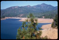
- Subject:
- Lakes & ponds, Tree limbs, Sacramento River (Calif.), Hills, Mountains, Shasta Lake (Calif.), Trees, and Rivers
- Series:
- 23-60
- Creator:
- Cushman, Charles W., 1896-1972
- Date Created:
- 1960-09-15
- Genre:
- Landscape photographs
- Frame Number:
- 8
- County:
- Shasta
- Abstract:
- Sacramento river north of Shasta Lake
- Call Number:
- P11630
- Country:
- United States
- State/Province:
- California
- Alternate Identifier:
- 2360.8
- Persistent URL:
- http://purl.dlib.indiana.edu/iudl/archives/cushman/P11630
- Holding Location:
- Bloomington - University Archives
Wells Library E460
1320 E 10th St.
Bloomington, IN 47405
Contact at archives@indiana.edu, 812-855-1127
-
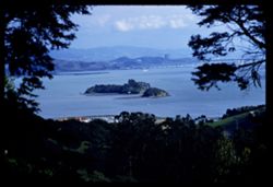
- Description:
- 100 f 5.6 TL
- Subject:
- Piers & wharves, Channels, Trees, San Pablo Strait (Calif.), Tree limbs, Mountains, Buildings, Bridges, Islands, and Hills
- Series:
- 2-60
- Creator:
- Cushman, Charles W., 1896-1972
- Date Created:
- 1960-03-08
- Genre:
- Landscape photographs
- Frame Number:
- 8
- County:
- Marin
- Abstract:
- From ht. East of S. Rafael - Marin Islands in San Pablo str.
- Call Number:
- P10939
- City:
- San Rafael
- Country:
- United States
- State/Province:
- California
- Alternate Identifier:
- 260.8
- Persistent URL:
- http://purl.dlib.indiana.edu/iudl/archives/cushman/P10939
- Holding Location:
- Bloomington - University Archives
Wells Library E460
1320 E 10th St.
Bloomington, IN 47405
Contact at archives@indiana.edu, 812-855-1127
-
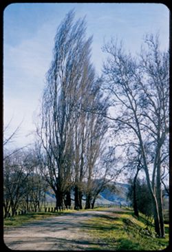
- Description:
- 50 f 6.3 sl
- Subject:
- Poplars, Roads, Trees, Meadows, Water Temple, Mountains, Fences, and Lombardy poplar
- Series:
- 1-58
- Creator:
- Cushman, Charles W., 1896-1972
- Date Created:
- 1958-01-18
- Genre:
- Landscape photographs
- Frame Number:
- 8
- County:
- Alameda
- Abstract:
- Bare Lombardy poplars
- Call Number:
- P09668
- City:
- Sunol
- Country:
- United States
- State/Province:
- California
- Alternate Identifier:
- 158.8
- Persistent URL:
- http://purl.dlib.indiana.edu/iudl/archives/cushman/P09668
- Holding Location:
- Bloomington - University Archives
Wells Library E460
1320 E 10th St.
Bloomington, IN 47405
Contact at archives@indiana.edu, 812-855-1127
-
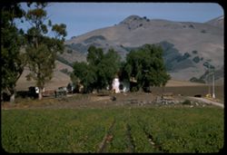
- Description:
- 100 f 6.3 tl
- Subject:
- Farmhouses, Outbuildings, Farms, Trees, Croplands, Hills, Truck farming, Farming, and Mountains
- Series:
- 18-57
- Creator:
- Cushman, Charles W., 1896-1972
- Date Created:
- 1957-12-01
- Genre:
- Views
- Frame Number:
- 8
- County:
- San Luis Obispo
- Abstract:
- Farm along Arroyo Grande
- Call Number:
- P09631
- City:
- Arroyo Grande
- Country:
- United States
- State/Province:
- California
- Alternate Identifier:
- 1857.8
- Persistent URL:
- http://purl.dlib.indiana.edu/iudl/archives/cushman/P09631
- Holding Location:
- Bloomington - University Archives
Wells Library E460
1320 E 10th St.
Bloomington, IN 47405
Contact at archives@indiana.edu, 812-855-1127
-
- Description:
- 100 f 8 tl
- Subject:
- Saint Helena, Mount (Calif.), Tree limbs, and Mountains
- Series:
- 16-57
- Creator:
- Cushman, Charles W., 1896-1972
- Date Created:
- 1957-11-05
- Genre:
- Landscape photographs
- Frame Number:
- 8
- Street Address:
- California State Highway 128
- County:
- Napa
- Abstract:
- Top of St Helena from S by W
- Call Number:
- P09574
- City:
- Calistoga
- Country:
- United States
- State/Province:
- California
- Alternate Identifier:
- 1657.8
- Persistent URL:
- http://purl.dlib.indiana.edu/iudl/archives/cushman/P09574
- Holding Location:
- Bloomington - University Archives
Wells Library E460
1320 E 10th St.
Bloomington, IN 47405
Contact at archives@indiana.edu, 812-855-1127
-
- Description:
- 100 f 6.3 tl
- Subject:
- Railings, Roads, Trees, San Luis Obispo, Cerro (Calif.), Mountains, Buildings, and Hills
- Series:
- 14-57
- Creator:
- Cushman, Charles W., 1896-1972
- Date Created:
- 1957-09-19
- Genre:
- Landscape photographs
- Frame Number:
- 8
- Street Address:
- United States Highway 101
- County:
- San Luis Obispo
- Abstract:
- San Luis O. Mtn from US 101 NE of San Luis O.
- Call Number:
- P09507
- Country:
- United States
- State/Province:
- California
- Alternate Identifier:
- 1457.8
- Persistent URL:
- http://purl.dlib.indiana.edu/iudl/archives/cushman/P09507
- Holding Location:
- Bloomington - University Archives
Wells Library E460
1320 E 10th St.
Bloomington, IN 47405
Contact at archives@indiana.edu, 812-855-1127
-
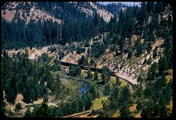
- Description:
- 100 f 5.6 tl
- Subject:
- Canyons, Feather River (Calif.), Trees, Western Pacific Railroad Company, Mountains, Railroad passenger cars, Feather River Canyon (Calif.), Railroads, River...
- Series:
- 12-57
- Creator:
- Cushman, Charles W., 1896-1972
- Date Created:
- 1957-07-25
- Genre:
- Landscape photographs and Snapshots
- Frame Number:
- 8
- County:
- Plumas
- Abstract:
- East bound WP passenger train along Feather river near Inn
- Call Number:
- P09453
- City:
- Cromberg
- Country:
- United States
- State/Province:
- California
- Alternate Identifier:
- 1257.8
- Persistent URL:
- http://purl.dlib.indiana.edu/iudl/archives/cushman/P09453
- Holding Location:
- Bloomington - University Archives
Wells Library E460
1320 E 10th St.
Bloomington, IN 47405
Contact at archives@indiana.edu, 812-855-1127
-
- Description:
- 100 f 8 tl
- Subject:
- Canyons, Cajon Canyon (Calif.), Mountains, Hills, and Cajon Pass (Calif.)
- Series:
- 7-57
- Creator:
- Cushman, Charles W., 1896-1972
- Date Created:
- 1957-05-14
- Genre:
- Landscape photographs
- Frame Number:
- 8
- County:
- San Bernardino
- Abstract:
- View down SE from Cajon summit of 4255' after lunch
- Call Number:
- P09287
- Country:
- United States
- State/Province:
- California
- Alternate Identifier:
- 757.8
- Persistent URL:
- http://purl.dlib.indiana.edu/iudl/archives/cushman/P09287
- Holding Location:
- Bloomington - University Archives
Wells Library E460
1320 E 10th St.
Bloomington, IN 47405
Contact at archives@indiana.edu, 812-855-1127
-
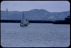
- Description:
- 100 f 5.6 tl
- Subject:
- Bays (Bodies of water), Piers & wharves, Sailboats, Golden Gate Bridge (San Francisco, Calif.), Suspension bridges, Mountains, and San Francisco Bay (Cal...
- Series:
- 2-57
- Creator:
- Cushman, Charles W., 1896-1972
- Date Created:
- 1957-03-30
- Genre:
- Marine photographs
- Frame Number:
- 8
- Street Address:
- North Beach
- County:
- Marin and San Francisco
- Abstract:
- View from former Sausalito ferry slip San Francisco
- Call Number:
- P09134
- City:
- San Francisco
- Country:
- United States
- State/Province:
- California
- Alternate Identifier:
- 257.8
- Persistent URL:
- http://purl.dlib.indiana.edu/iudl/archives/cushman/P09134
- Holding Location:
- Bloomington - University Archives
Wells Library E460
1320 E 10th St.
Bloomington, IN 47405
Contact at archives@indiana.edu, 812-855-1127
-

- Description:
- 100 f 8 tl
- Subject:
- Safflower, Flowers, Croplands, Farms, and Mountains
- Series:
- 11-56
- Creator:
- Cushman, Charles W., 1896-1972
- Date Created:
- 1956-07-15
- Genre:
- Landscape photographs
- Frame Number:
- 8
- County:
- Yolo
- Abstract:
- Yolo county fields & mtns - field of safflowers
- Call Number:
- P08906
- Country:
- United States
- State/Province:
- California
- Alternate Identifier:
- 1156.8
- Persistent URL:
- http://purl.dlib.indiana.edu/iudl/archives/cushman/P08906
- Holding Location:
- Bloomington - University Archives
Wells Library E460
1320 E 10th St.
Bloomington, IN 47405
Contact at archives@indiana.edu, 812-855-1127
-
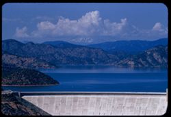
- Description:
- 100 f 8 tl
- Subject:
- Shasta Lake (Calif.), Trees, Coastlines, Mountains, Lakes & ponds, Clouds, Dams, and Shasta Dam (Calif.)
- Series:
- 11-56
- Creator:
- Cushman, Charles W., 1896-1972
- Date Created:
- 1956-07-14
- Genre:
- Landscape photographs
- Frame Number:
- 8
- County:
- Shasta
- Abstract:
- Shasta Lake from ft. above dam
- Call Number:
- P08904
- Country:
- United States
- State/Province:
- California
- Alternate Identifier:
- 1156.6
- Persistent URL:
- http://purl.dlib.indiana.edu/iudl/archives/cushman/P08904
- Holding Location:
- Bloomington - University Archives
Wells Library E460
1320 E 10th St.
Bloomington, IN 47405
Contact at archives@indiana.edu, 812-855-1127
-
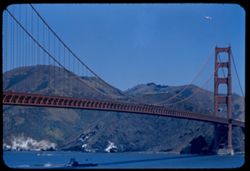
- Description:
- 100 f 6.3 TL
- Subject:
- Bays (Bodies of water), Golden Gate Bridge (San Francisco, Calif.), Submarines, Suspension bridges, Coastlines, USS Toledo, Mountains, Sea Wolf, and San Fran...
- Series:
- 7-56
- Creator:
- Cushman, Charles W., 1896-1972
- Date Created:
- 1956-06-08
- Genre:
- Marine photographs
- Frame Number:
- 8
- County:
- San Francisco
- Abstract:
- Sub 4H7 Sea Wolf leads after USS Toledo
- Call Number:
- P08755
- City:
- San Francisco
- Country:
- United States
- State/Province:
- California
- Alternate Identifier:
- 756.8
- Persistent URL:
- http://purl.dlib.indiana.edu/iudl/archives/cushman/P08755
- Holding Location:
- Bloomington - University Archives
Wells Library E460
1320 E 10th St.
Bloomington, IN 47405
Contact at archives@indiana.edu, 812-855-1127
-
- Description:
- 50 mm 1/100 short lens
- Subject:
- Meadows, Diablo, Mount (Calif.), Hills, Mountains, Trees, Utility poles, Roads, and Clouds
- Series:
- 1-56
- Creator:
- Cushman, Charles W., 1896-1972
- Date Created:
- 1956-02-23
- Genre:
- Landscape photographs
- Frame Number:
- 8
- Street Address:
- Norris Canyon Road
- County:
- Contra Costa
- Abstract:
- Mt. Diablo
- Call Number:
- P08537
- Country:
- United States
- State/Province:
- California
- Alternate Identifier:
- 156.8
- Persistent URL:
- http://purl.dlib.indiana.edu/iudl/archives/cushman/P08537
- Holding Location:
- Bloomington - University Archives
Wells Library E460
1320 E 10th St.
Bloomington, IN 47405
Contact at archives@indiana.edu, 812-855-1127
-
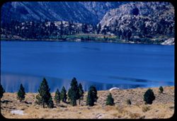
- Description:
- 100 f 5.6 tl
- Subject:
- Lakes & ponds, June Lake (Calif.), Mountains, and Trees
- Series:
- 27-55
- Creator:
- Cushman, Charles W., 1896-1972
- Date Created:
- 1955-09-26
- Genre:
- Landscape photographs
- Frame Number:
- 8
- County:
- Mono
- Abstract:
- June Lake 70,316 mi.
- Call Number:
- P08428
- Country:
- United States
- State/Province:
- California
- Alternate Identifier:
- 2755.8
- Persistent URL:
- http://purl.dlib.indiana.edu/iudl/archives/cushman/P08428
- Holding Location:
- Bloomington - University Archives
Wells Library E460
1320 E 10th St.
Bloomington, IN 47405
Contact at archives@indiana.edu, 812-855-1127
-
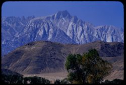
- Description:
- 100 f 8 tl
- Subject:
- Initials, Trees, Lone Pine Peak (Calif.), Mountains, Alabama Hills (Calif.), and Hills
- Series:
- 26-55
- Creator:
- Cushman, Charles W., 1896-1972
- Date Created:
- 1955-09-25
- Genre:
- Landscape photographs
- Frame Number:
- 8
- County:
- Inyo
- Abstract:
- Lone Pine Mt beyond Alabama Hills
- Call Number:
- P08391
- Country:
- United States
- State/Province:
- California
- Alternate Identifier:
- 2655.8
- Persistent URL:
- http://purl.dlib.indiana.edu/iudl/archives/cushman/P08391
- Holding Location:
- Bloomington - University Archives
Wells Library E460
1320 E 10th St.
Bloomington, IN 47405
Contact at archives@indiana.edu, 812-855-1127
-
![From Calif. Hwy 89 near El Dorado - Alpine county line View S.E. toward Pickett [9170 ft.] and Hawkins [10,060 ft.] peaks](https://iiif.uits.iu.edu/iiif/2/q811kk24j%2Ffiles%2F87311fdd-2730-4040-8d16-48bf68e22e97/full/250,/0/default.jpg)
- Description:
- 100 f 6.3 TL
- Subject:
- Pickett Peak (Alpine County, Calif.), Trees, Moon, Mountains, and Hawkins Peak (Alpine County, Calif.)
- Series:
- 25-55
- Creator:
- Cushman, Charles W., 1896-1972
- Date Created:
- 1955-09-24
- Genre:
- Landscape photographs
- Frame Number:
- 8
- Street Address:
- California State Highway 89
- County:
- El Dorado and Alpine
- Abstract:
- Mtns to SE with 1/2 moon Pickett Pk 9170 ft. Hawkins Pk. 10,060 ft. [P] From just below (east) of Luther Pass (7740 ft.)
- Call Number:
- P08356
- Country:
- United States
- State/Province:
- California
- Alternate Identifier:
- 2555.8
- Persistent URL:
- http://purl.dlib.indiana.edu/iudl/archives/cushman/P08356
- Holding Location:
- Bloomington - University Archives
Wells Library E460
1320 E 10th St.
Bloomington, IN 47405
Contact at archives@indiana.edu, 812-855-1127
-
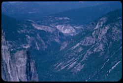
- Description:
- 100 f 6.3 tl
- Subject:
- Yosemite Valley (Calif.), Valleys, Yosemite National Park (Calif.), Trees, Half Dome (Calif.), Mountains, National parks & reserves, and Rock formations
- Series:
- 21-55
- Creator:
- Cushman, Charles W., 1896-1972
- Date Created:
- 1955-07-08
- Genre:
- Landscape photographs
- Frame Number:
- 8
- County:
- Mariposa
- Abstract:
- View down the Valley
- Call Number:
- P08226
- Country:
- United States
- State/Province:
- California
- Alternate Identifier:
- 2155.8
- Persistent URL:
- http://purl.dlib.indiana.edu/iudl/archives/cushman/P08226
- Holding Location:
- Bloomington - University Archives
Wells Library E460
1320 E 10th St.
Bloomington, IN 47405
Contact at archives@indiana.edu, 812-855-1127
-
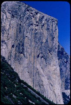
- Description:
- 100 f 8 tl
- Subject:
- Mountains, Shrubs, El Capitan (Calif.), and Trees
- Series:
- 20-55
- Creator:
- Cushman, Charles W., 1896-1972
- Date Created:
- 1955-07-07
- Genre:
- Landscape photographs
- Frame Number:
- 8
- County:
- Mariposa
- Abstract:
- El Capitan
- Call Number:
- P08192
- Country:
- United States
- State/Province:
- California
- Alternate Identifier:
- 2055.8
- Persistent URL:
- http://purl.dlib.indiana.edu/iudl/archives/cushman/P08192
- Holding Location:
- Bloomington - University Archives
Wells Library E460
1320 E 10th St.
Bloomington, IN 47405
Contact at archives@indiana.edu, 812-855-1127
-
- Description:
- 100 f 4.5 tl
- Subject:
- Redwood Creek (Humboldt County, Calif.), Hills, Roads, Mountains, Trees, Clouds, and Berry Summit (Calif.)
- Series:
- 16-55
- Creator:
- Cushman, Charles W., 1896-1972
- Date Created:
- 1955-06-15
- Genre:
- Landscape photographs
- Frame Number:
- 8
- Street Address:
- United States Highway 299
- County:
- Humboldt
- Abstract:
- 65423 mi. Looking across Redwood Creek Valley from up road toward Berry Summit
- Call Number:
- P08053
- Country:
- United States
- State/Province:
- California
- Alternate Identifier:
- 1655.8
- Persistent URL:
- http://purl.dlib.indiana.edu/iudl/archives/cushman/P08053
- Holding Location:
- Bloomington - University Archives
Wells Library E460
1320 E 10th St.
Bloomington, IN 47405
Contact at archives@indiana.edu, 812-855-1127
-
- Description:
- 100 f 6 tl
- Subject:
- Lakes & ponds, Deserts, Reflections, Valleys, Black Mountains (Inyo County, Calif.), Death Valley (Calif. and Nev.), Mountains, and Shrubs
- Series:
- 12-55
- Creator:
- Cushman, Charles W., 1896-1972
- Date Created:
- 1955-03-24
- Genre:
- Landscape photographs
- Frame Number:
- 8
- County:
- Inyo
- Abstract:
- Desert lake near Tecopa - view N.W.
- Call Number:
- P07904
- City:
- Tecopa
- Country:
- United States
- State/Province:
- California
- Alternate Identifier:
- 1255.8
- Persistent URL:
- http://purl.dlib.indiana.edu/iudl/archives/cushman/P07904
- Holding Location:
- Bloomington - University Archives
Wells Library E460
1320 E 10th St.
Bloomington, IN 47405
Contact at archives@indiana.edu, 812-855-1127
-
- Description:
- 100 f 8 tl
- Subject:
- Valleys, Greasewood, Mountains, Shrubs, Clouds, and Death Valley (Calif. and Nev.)
- Series:
- 11-55
- Creator:
- Cushman, Charles W., 1896-1972
- Date Created:
- 1955-03-23
- Genre:
- Identification photographs
- Frame Number:
- 8
- County:
- Inyo
- Abstract:
- Greasewood in bloom.
- Call Number:
- P07870
- Country:
- United States
- State/Province:
- California
- Alternate Identifier:
- 1155.8
- Persistent URL:
- http://purl.dlib.indiana.edu/iudl/archives/cushman/P07870
- Holding Location:
- Bloomington - University Archives
Wells Library E460
1320 E 10th St.
Bloomington, IN 47405
Contact at archives@indiana.edu, 812-855-1127
-
- Description:
- 100 f 8 tl
- Subject:
- Rocks, Valleys, Trails & paths, Mountains, Lara Stream, Zabriskie Point (Calif.), and Death Valley National Park (Calif. and Nev.)
- Series:
- 9-55
- Creator:
- Cushman, Charles W., 1896-1972
- Date Created:
- 1955-03-22
- Genre:
- Landscape photographs
- Frame Number:
- 8
- County:
- Inyo
- Abstract:
- natural road way below Zabriskie Pt
- Call Number:
- P07800
- Country:
- United States
- State/Province:
- California
- Alternate Identifier:
- 955.8
- Persistent URL:
- http://purl.dlib.indiana.edu/iudl/archives/cushman/P07800
- Holding Location:
- Bloomington - University Archives
Wells Library E460
1320 E 10th St.
Bloomington, IN 47405
Contact at archives@indiana.edu, 812-855-1127
-
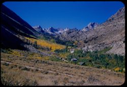
- Description:
- 50 f 10
- Subject:
- Mountains, Shrubs, Sierra Nevada (Calif. and Nev.), and Grasses
- Series:
- 12-54
- Creator:
- Cushman, Charles W., 1896-1972
- Date Created:
- 1954-09-18
- Genre:
- Landscape photographs
- Frame Number:
- 8
- Street Address:
- Glacier Lodge Road
- County:
- Inyo
- Abstract:
- White top of Pyramidal peak - from Glacier Lodge.
- Call Number:
- P07398
- City:
- Big Pine
- Country:
- United States
- State/Province:
- California
- Alternate Identifier:
- 1254.8
- Persistent URL:
- http://purl.dlib.indiana.edu/iudl/archives/cushman/P07398
- Holding Location:
- Bloomington - University Archives
Wells Library E460
1320 E 10th St.
Bloomington, IN 47405
Contact at archives@indiana.edu, 812-855-1127
-
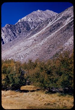
- Description:
- 50 f 10
- Subject:
- Sabrina, Lake (Calif.), Canyons, Valleys, Mountains, Shrubs, Sierra Nevada (Calif. and Nev.), Trees, Rocks, and Dwellings
- Series:
- 11-54
- Creator:
- Cushman, Charles W., 1896-1972
- Date Created:
- 1954-09-17
- Genre:
- Landscape photographs
- Frame Number:
- 8
- County:
- Inyo
- Abstract:
- Up canyon of yellow trees.
- Call Number:
- P07377
- Country:
- United States
- State/Province:
- California
- Alternate Identifier:
- 1154.8
- Persistent URL:
- http://purl.dlib.indiana.edu/iudl/archives/cushman/P07377
- Holding Location:
- Bloomington - University Archives
Wells Library E460
1320 E 10th St.
Bloomington, IN 47405
Contact at archives@indiana.edu, 812-855-1127
-
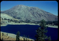
- Description:
- 50 f 9
- Subject:
- Bodies of water, Yosemite National Park (Calif.), Trees, Coastlines, Tioga Peak (Calif.), Mountains, Shrubs, Lakes & ponds, and Tioga Lake (Calif.)
- Series:
- 10-54
- Creator:
- Cushman, Charles W., 1896-1972
- Date Created:
- 1954-09-16
- Genre:
- Landscape photographs
- Frame Number:
- 8
- County:
- Mono
- Abstract:
- Tioga Lake and Tioga Pk. Tioga Peak 11,537 ft.
- Call Number:
- P07355
- Country:
- United States
- State/Province:
- California
- Physical Description:
- Anscochrome film.
- Alternate Identifier:
- 1054.8
- Persistent URL:
- http://purl.dlib.indiana.edu/iudl/archives/cushman/P07355
- Holding Location:
- Bloomington - University Archives
Wells Library E460
1320 E 10th St.
Bloomington, IN 47405
Contact at archives@indiana.edu, 812-855-1127
-
- Description:
- 50 f 8
- Subject:
- Sonora Pass (Calif.), Trees, Mountains, and Leavitt Peak (Calif.)
- Series:
- 9-54
- Creator:
- Cushman, Charles W., 1896-1972
- Date Created:
- 1954-09-15
- Genre:
- Landscape photographs
- Frame Number:
- 8
- County:
- Tuolumne
- Abstract:
- Leavitt Peak. 203 mi. 11,575 ft.
- Call Number:
- P07319
- Country:
- United States
- State/Province:
- California
- Alternate Identifier:
- 954.8
- Persistent URL:
- http://purl.dlib.indiana.edu/iudl/archives/cushman/P07319
- Holding Location:
- Bloomington - University Archives
Wells Library E460
1320 E 10th St.
Bloomington, IN 47405
Contact at archives@indiana.edu, 812-855-1127
-
- Description:
- 50 f 7
- Subject:
- Rocks, Cascade Falls (Calif.), Trees, Volcanoes, Lassen Volcanic National Park (Calif.), Mountains, Shrubs, and Diamond Peak (Shasta County, Calif.)
- Series:
- 7-54
- Creator:
- Cushman, Charles W., 1896-1972
- Date Created:
- 1954-08-21
- Genre:
- Landscape photographs
- Frame Number:
- 8
- County:
- Shasta
- Abstract:
- Diamond Pk.
- Call Number:
- P07263
- Country:
- United States
- State/Province:
- California
- Alternate Identifier:
- 754.8
- Persistent URL:
- http://purl.dlib.indiana.edu/iudl/archives/cushman/P07263
- Holding Location:
- Bloomington - University Archives
Wells Library E460
1320 E 10th St.
Bloomington, IN 47405
Contact at archives@indiana.edu, 812-855-1127
-
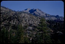
- Description:
- 50 f 9
- Subject:
- Cascade Range, Valleys, Trees, Volcanoes, Volcanic domes, Lassen Volcanic National Park (Calif.), Mountains, Shrubs, Clouds, Bumpass Mountain (Calif.), Shado...
- Series:
- 6-54
- Creator:
- Cushman, Charles W., 1896-1972
- Date Created:
- 1954-08-19
- Genre:
- Landscape photographs
- Frame Number:
- 8
- County:
- Shasta
- Abstract:
- Mass of Bumpass.
- Call Number:
- P07226
- Country:
- United States
- State/Province:
- California
- Alternate Identifier:
- 654.8
- Persistent URL:
- http://purl.dlib.indiana.edu/iudl/archives/cushman/P07226
- Holding Location:
- Bloomington - University Archives
Wells Library E460
1320 E 10th St.
Bloomington, IN 47405
Contact at archives@indiana.edu, 812-855-1127
-
- Description:
- 50 f 8
- Subject:
- Raker Peak (Calif.), Lassen Peak (Calif.), Lassen Volcanic National Park (Calif.), Volcanic domes, Mountains, Shrubs, Trees, Rocks, Clouds, Volcanoes, Lava d...
- Series:
- 5-54
- Creator:
- Cushman, Charles W., 1896-1972
- Date Created:
- 1954-08-19
- Genre:
- Landscape photographs
- Frame Number:
- 8
- County:
- Shasta
- Abstract:
- South side Raker Mtn (seen in 4)- this time mainly green
- Call Number:
- P07204
- Country:
- United States
- State/Province:
- California
- Physical Description:
- Anscochrome film.
- Alternate Identifier:
- 554.8
- Persistent URL:
- http://purl.dlib.indiana.edu/iudl/archives/cushman/P07204
- Holding Location:
- Bloomington - University Archives
Wells Library E460
1320 E 10th St.
Bloomington, IN 47405
Contact at archives@indiana.edu, 812-855-1127
-
- Description:
- 50 f 8
- Subject:
- Rocks, Trees, Cajon Pass (Calif.), Rock formations, Passes (Landforms), Mountains, and Hills
- Series:
- 16-53
- Creator:
- Cushman, Charles W., 1896-1972
- Date Created:
- 1953-11-23
- Genre:
- Landscape photographs
- Frame Number:
- 8
- Street Address:
- California State Highway 138
- County:
- San Bernardino
- Abstract:
- Tilted rocks along Cal 138 nr. Cajon
- Call Number:
- P07080
- Country:
- United States
- State/Province:
- California
- Alternate Identifier:
- 1653.8
- Persistent URL:
- http://purl.dlib.indiana.edu/iudl/archives/cushman/P07080
- Holding Location:
- Bloomington - University Archives
Wells Library E460
1320 E 10th St.
Bloomington, IN 47405
Contact at archives@indiana.edu, 812-855-1127
-
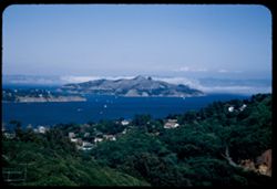
- Description:
- 25 f 6.3 Pola
- Subject:
- Bays (Bodies of water), Roads, Angel Island (Calif.), Fog, Trees, Mountains, Islands, Hills, North Bay (Humboldt County, Calif.), San Francisco Bay (Calif.),...
- Series:
- 8-53
- Creator:
- Cushman, Charles W., 1896-1972
- Date Created:
- 1953-08-30
- Genre:
- Landscape photographs
- Frame Number:
- 8
- County:
- Marin
- Abstract:
- Looking down on Angel Island from heights above Sausalito with fog over North Bay.
- Call Number:
- P06770
- City:
- Sausalito
- Country:
- United States
- State/Province:
- California
- Alternate Identifier:
- 853.8
- Persistent URL:
- http://purl.dlib.indiana.edu/iudl/archives/cushman/P06770
- Holding Location:
- Bloomington - University Archives
Wells Library E460
1320 E 10th St.
Bloomington, IN 47405
Contact at archives@indiana.edu, 812-855-1127
-
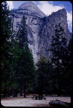
- Description:
- 50 f 6.3
- Subject:
- Valleys, Yosemite National Park (Calif.), North Dome (Calif.), Mountains, Trees, Yosemite Valley (Calif.), National parks & reserves, Picnic grounds, Tab...
- Series:
- 6-53
- Creator:
- Cushman, Charles W., 1896-1972
- Date Created:
- 1953-05-14
- Genre:
- Landscape photographs
- Frame Number:
- 8
- County:
- Mariposa
- Abstract:
- North Dome from Valley
- Call Number:
- P06696
- Country:
- United States
- State/Province:
- California
- Alternate Identifier:
- 653.8
- Persistent URL:
- http://purl.dlib.indiana.edu/iudl/archives/cushman/P06696
- Holding Location:
- Bloomington - University Archives
Wells Library E460
1320 E 10th St.
Bloomington, IN 47405
Contact at archives@indiana.edu, 812-855-1127
-
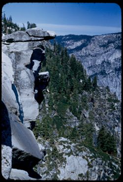
- Description:
- 50 f 9
- Subject:
- National parks & reserves, Mountains, Yosemite National Park (Calif.), Shrubs, Trees, Glacier Point (Calif.), Yosemite Valley (Calif.), and Rock formations
- Series:
- 5-53
- Creator:
- Cushman, Charles W., 1896-1972
- Date Created:
- 1953-05-13
- Genre:
- Landscape photographs
- Frame Number:
- 8
- County:
- Mariposa
- Abstract:
- Overhanging rock.
- Call Number:
- P06658
- Country:
- United States
- State/Province:
- California
- Alternate Identifier:
- 553.8
- Persistent URL:
- http://purl.dlib.indiana.edu/iudl/archives/cushman/P06658
- Holding Location:
- Bloomington - University Archives
Wells Library E460
1320 E 10th St.
Bloomington, IN 47405
Contact at archives@indiana.edu, 812-855-1127
-
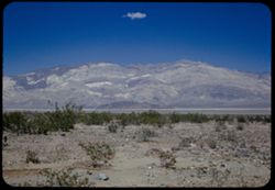
- Description:
- 25 f 9 Pola
- Subject:
- Panamint Mountains (Calif.), Valleys, Panamint Valley (Calif.), Panamint Range (Calif.), Shrubs, Rocks, and Mountains
- Series:
- 15-52
- Creator:
- Cushman, Charles W., 1896-1972
- Date Created:
- 1952-04-08
- Genre:
- Landscape photographs
- Frame Number:
- 8
- County:
- Inyo
- Abstract:
- Across Panamint Valley to Panamint Mtns from Panamint Springs.
- Call Number:
- P06029
- City:
- Panamint Springs
- Country:
- United States
- State/Province:
- California
- Alternate Identifier:
- 1552.8
- Persistent URL:
- http://purl.dlib.indiana.edu/iudl/archives/cushman/P06029
- Holding Location:
- Bloomington - University Archives
Wells Library E460
1320 E 10th St.
Bloomington, IN 47405
Contact at archives@indiana.edu, 812-855-1127
-
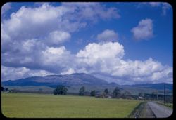
- Description:
- 25 f 11
- Subject:
- Grasses, Tehachapi Mountains (Calif.), Trees, Meadows, Croplands, Clouds, Hills, and Mountains
- Series:
- 14-52
- Creator:
- Cushman, Charles W., 1896-1972
- Date Created:
- 1952-04-07
- Genre:
- Landscape photographs
- Frame Number:
- 8
- Street Address:
- United States Highway 466
- County:
- Kern
- Abstract:
- Along Hwy 466 between Bakersfield and Tehachapi.
- Call Number:
- P05992
- City:
- Tehachapi and Bakersfield
- Country:
- United States
- State/Province:
- California
- Alternate Identifier:
- 1452.8
- Persistent URL:
- http://purl.dlib.indiana.edu/iudl/archives/cushman/P05992
- Holding Location:
- Bloomington - University Archives
Wells Library E460
1320 E 10th St.
Bloomington, IN 47405
Contact at archives@indiana.edu, 812-855-1127