
Search Constraints
You searched for:
Campus
IUB
Remove constraint Campus: IUB
Holding Location
B-WELLS
Remove constraint Holding Location: B-WELLS
Pages
0-99 pages
Remove constraint Pages: 0-99 pages
Subject
Geographic Subject: Indiana
Remove constraint Subject: Geographic Subject: Indiana
« Previous |
1 - 20 of 438
|
Next »
Search Results
-
- Subject:
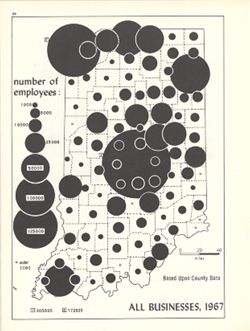
- Topical Subject: Labor supply, Topical Subject: Business enterprises--Employees, and Geographic Subject: Indiana
- Creator:
- Hollingsworth, John M. and Kingsbury, Robert C.
- Publisher:
- Indiana University. Department of Geography
- Date Created:
- 1970
- Identifier:
- VAC3073-M-00226
- Genre:
- Thematic maps
- Geographic Location:
- Coordinates: W0880700 W0844500 N0414500 N0374600
- Related URL:
- Catalog URL: https://iucat.iu.edu/catalog/15948581
- Abstract:
- Graduated symbol map. Shows number of employees by county. Detached from: An atlas of Indiana / by Robert C. Kingsbury , with contributions from John M. H...
- Call Number:
- G4091.G8 1967 .K56
- Caption:
- Imprint: Bloomington, Indiana : Department of Geography, Indiana University, [1970]
- Physical Description:
- Dimensions: 26 x 18 cm, on sheet 28 x 21 cm and Scale: Approximately 1:1,950,000
- Alternate Identifier:
- Alternate ID: 317383IP and Title Control Number: a15948581
- Persistent URL:
- https://purl.dlib.indiana.edu/iudl/images/VAC3073/VAC3073-M-00226
- Provenance:
- An atlas of Indiana / by Robert C. Kingsbury [1970].
-
- Subject:
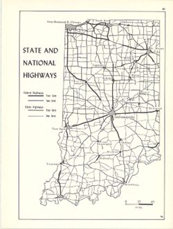
- Geographic Subject: Indiana and Topical Subject: Roads
- Creator:
- Hollingsworth, John M. and Kingsbury, Robert C.
- Publisher:
- Indiana University. Department of Geography
- Date Created:
- 1970
- Identifier:
- VAC3073-M-00815
- Genre:
- Road maps
- Geographic Location:
- Coordinates: W0880700 W0844500 N0414500 N0374600
- Related URL:
- Catalog URL: https://iucat.iu.edu/catalog/15938064
- Abstract:
- Shows two lane and four lane federal highways and two lane and four lane state highways. Detached from: An atlas of Indiana / by Robert C. Kingsbury , wit...
- Call Number:
- G4091.P2 1970 .K56
- Caption:
- Imprint: Bloomington, Indiana : Department of Geography, Indiana University, [1970]
- Physical Description:
- Scale: Approximately 1:2,000,000 and Dimensions: 26 x 18 cm, on sheet 28 x 21 cm
- Alternate Identifier:
- Alternate ID: 317383IP and Title Control Number: a15938064
- Persistent URL:
- https://purl.dlib.indiana.edu/iudl/images/VAC3073/VAC3073-M-00815
- Provenance:
- An atlas of Indiana / by Robert C. Kingsbury [1970].
-
- Subject:
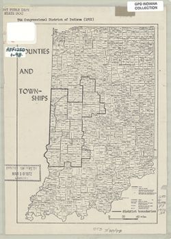
- Geographic Subject: Indianapolis Region (Ind.), Geographic Subject: Marion County (Ind.), Geographic Subject: Indiana, and Topical Subject: Election districts
- Publisher:
- Indiana University, Bloomington. Department of Geography
- Date Created:
- 1972
- Identifier:
- VAC3073-M-00314
- Genre:
- Thematic maps
- Geographic Location:
- Coordinates: W0880500 W0844700 N0414500 N0374600
- Related URL:
- Catalog URL: https://iucat.iu.edu/catalog/1025068
- Abstract:
- Boundaries of 7th Congressional District of Indiana in 1972 drawn on a copy of "Counties and townships" map, p. 10 of Kingsbury, Robert C., An atla...
- Call Number:
- G4091 .F7 1972 .S4
- Caption:
- Imprint: [Indiana] : [Department of Geography, Indiana University], [1970]
- Physical Description:
- Scale: Approximately 1:825,000 and Dimensions: 25 x 18 cm
- Alternate Identifier:
- Title Control Number: a16178039 and Alternate ID: AJF1250BB
- Persistent URL:
- https://purl.dlib.indiana.edu/iudl/images/VAC3073/VAC3073-M-00314
-
- Subject:
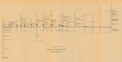
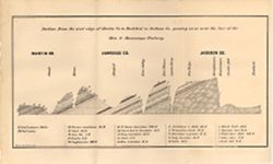
- Geographic Subject: Richmond (Ind.), Topical Subject: IGS Annual Reports, Geographic Subject: Madison (Ind.), Topical Subject: Stratigraphic correlation, Top...
- Creator:
- Cumings, E. R. (Edgar Roscoe), 1874-1967
- Publisher:
- Indiana. Department of Geology and Natural Resources
- Date Created:
- 1908
- Identifier:
- VAC3073-M-00056
- Genre:
- Charts and Geological cross-sections
- Geographic Location:
- Coordinates: W0852400 W0844800 N0395000 N0384000
- Related URL:
- Catalog URL: https://iucat.iu.edu/catalog/18298808
- Abstract:
- Includes 17 stratigraphic columns and correlation lines. Detached from: The stratigraphy and paleontology of the Cincinnati series of Indiana / E.R. Cumin...
- Call Number:
- G4091.C57 1908 .C86
- Caption:
- Imprint: [Indianapolis] : [Wm. B. Burford], [1908] and Imprint: [Indianapolis] : [Indiana Department of Geology and Natural Resources], [1908]
- Physical Description:
- Dimensions: on sheet 32 x 60 cm and Scale: Scale not given.
- Alternate Identifier:
- Title Control Number: a18298808 and Alternate ID: 390726IP
- Persistent URL:
- https://purl.dlib.indiana.edu/iudl/images/VAC3073/VAC3073-M-00056
- Provenance:
- 32nd Annual Report (1907) / Indiana. Department of Geology and Natural Resources.
-
- Subject:
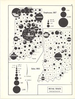
- Topical Subject: Retail trade--Employees, Geographic Subject: Indiana, and Topical Subject: Labor supply
- Creator:
- Hollingsworth, John M. and Kingsbury, Robert C.
- Publisher:
- Indiana University. Department of Geography
- Date Created:
- 1970
- Identifier:
- VAC3073-M-00179
- Genre:
- Thematic maps
- Geographic Location:
- Coordinates: W0880700 W0844500 N0414500 N0374600
- Related URL:
- Catalog URL: https://iucat.iu.edu/catalog/15987122
- Abstract:
- 2 maps on 1 sheet, Retail trade employees, 1967, and Retail trade sales, 1963. Graduated symbol map. Detached from: An atlas of Indiana / by Robert C. Kin...
- Call Number:
- G4091.G8 1963 .K57
- Caption:
- Imprint: Bloomington, Indiana : Department of Geography, Indiana University, [1970]
- Physical Description:
- Dimensions: on sheet 28 x 21 cm and Scale: Approximately 1:2,700,000
- Alternate Identifier:
- Alternate ID: 317383IP and Title Control Number: a15987122
- Persistent URL:
- https://purl.dlib.indiana.edu/iudl/images/VAC3073/VAC3073-M-00179
- Provenance:
- An atlas of Indiana / by Robert C. Kingsbury [1970].
-
- Subject:
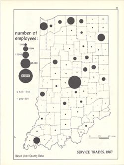
- Topical Subject: Service industries workers, Geographic Subject: Indiana, and Topical Subject: Labor supply
- Creator:
- Hollingsworth, John M. and Kingsbury, Robert C.
- Publisher:
- Indiana University. Department of Geography
- Date Created:
- 1970
- Identifier:
- VAC3073-M-00224
- Genre:
- Thematic maps
- Geographic Location:
- Coordinates: W0880700 W0844500 N0414500 N0374600
- Related URL:
- Catalog URL: https://iucat.iu.edu/catalog/15950444
- Abstract:
- Graduated symbol map. Shows number of employees by county. Detached from: An atlas of Indiana / by Robert C. Kingsbury , with contributions from John M. H...
- Call Number:
- G4091.G8 1967 .K57
- Caption:
- Imprint: Bloomington, Indiana : Department of Geography, Indiana University, [1970]
- Physical Description:
- Dimensions: 26 x 18 cm, on sheet 28 x 21 cm and Scale: Approximately 1:1,950,000
- Alternate Identifier:
- Alternate ID: 317383IP and Title Control Number: a15950444
- Persistent URL:
- https://purl.dlib.indiana.edu/iudl/images/VAC3073/VAC3073-M-00224
- Provenance:
- An atlas of Indiana / by Robert C. Kingsbury [1970].
-
- Subject:
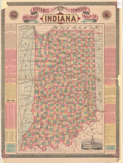
- Geographic Subject: Indiana and Topical Subject: Railroads
- Creator:
- Bridgman, E. C.
- Publisher:
- Bridgman, E. C.
- Date Created:
- 1871
- Identifier:
- VAC3073-M-00153
- Genre:
- Thematic maps
- Geographic Location:
- Coordinates: W0880700 W0844500 N0414500 N0375200
- Related URL:
- Catalog URL: https://iucat.iu.edu/catalog/5052641
- Abstract:
- Shows railroads, counties, townships, cities, towns, and railroad stations. Includes "Description on Indiana", 1870 census figures for counties, ci...
- Call Number:
- G4090 1871 .B75
- Caption:
- Imprint: New York : E.C. Bridgman, c1871.
- Physical Description:
- Dimensions: 69 x 46 cm and Scale: 1:675,000
- Alternate Identifier:
- Title Control Number: a5052641
- Persistent URL:
- https://purl.dlib.indiana.edu/iudl/images/VAC3073/VAC3073-M-00153
-
- Subject:
- Topical Subject: IGS Annual Reports and Geographic Subject: Indiana
- Publisher:
- Indiana. Geological Survey
- Date Created:
- 1875
- Identifier:
- VAC3073-M-01173
- Genre:
- Geological cross-sections
- Related URL:
- Catalog URL: https://iucat.iu.edu/catalog/4022269
- Abstract:
- Lawrence Co.
- Call Number:
- QE109 . A2 1874 map p42
- Caption:
- Imprint: Indianapolis : 1875.
- Physical Description:
- Dimensions: 21 x 34 cm.
- Persistent URL:
- https://purl.dlib.indiana.edu/iudl/images/VAC3073/VAC3073-M-01173
- Provenance:
- 6th Annual Report (1874) / Indiana. Geological Survey.
-
- Subject:
- Geographic Subject: Indiana, Topical Subject: Gas fields, Topical Subject: Petroleum, and Topical Subject: IGS Annual Reports
- Creator:
- Ashley, Geo. H. (George Hall), 1866-1951
- Publisher:
- Indiana. Department of Geology and Natural Resources
- Date Created:
- 1897
- Identifier:
- VAC3073-M-01153
- Genre:
- Geological maps
- Geographic Location:
- Coordinates: W0854200 W0845200 N0404600 N0402300
- Related URL:
- Catalog URL: https://iucat.iu.edu/catalog/17188279
- Abstract:
- To accompany the report on the petroleum industry in Indiana by W.S. Blatchley, state geologist : annual report of the Department of Geology and Natural Reso...
- Call Number:
- G4091.H8 1896 .A8
- Caption:
- Imprint: [Indianapolis] : Department of Geology and Natural Resources of Indiana, [1897]
- Physical Description:
- Dimensions: 35 x 60 cm and Scale: Approximately 1:126,720. 2 miles = 1 inch
- Alternate Identifier:
- Title Control Number: a17188279 and Alternate ID: 390726IP
- Persistent URL:
- https://purl.dlib.indiana.edu/iudl/images/VAC3073/VAC3073-M-01153
- Provenance:
- 21st Annual Report (1896) / Indiana. Department of Geology and Natural Resources.
-
- Subject:
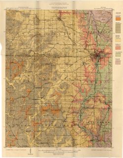
- Geographic Subject: Monroe County (Ind.), Geographic Subject: Greene County (Ind.), Geographic Subject: Indiana, Geographic Subject: Owen County (Ind.), and ...
- Publisher:
- Indiana. Department of Geology and Natural Resources
- Date Created:
- 1915
- Identifier:
- VAC3073-M-01188
- Genre:
- Quadrangle maps, Topographic maps, and Geological maps
- Geographic Location:
- Coordinates: W0864500 W0863000 N0391500 N0390000
- Related URL:
- Catalog URL: https://iucat.iu.edu/catalog/16190483
- Abstract:
- Relief shown by contours and spot heights. Contour interval 20 feet. Shows limestone locations in a portion of Monroe County and small portions of Owen and G...
- Call Number:
- G4093.M7C5 1914 .I6
- Caption:
- Imprint: [Indianapolis] : Indiana Dept. of Geology [and Natural Resources], [1915] and Imprint: [Indianapolis] : [Wm. B. Burford], [1915]
- Physical Description:
- Scale: 1:62,500 and Dimensions: 45 x 35 cm
- Alternate Identifier:
- Title Control Number: a16190483 and Alternate ID: 390726IP
- Persistent URL:
- https://purl.dlib.indiana.edu/iudl/images/VAC3073/VAC3073-M-01188
- Provenance:
- 39th Annual Report (1914) / Indiana. Department of Geology and Natural Resources.
-
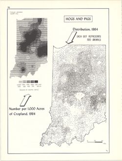
- Subject:
- Geographic Subject: Indiana, Topical Subject: Swine--Geographical distribution, and Topical Subject: SYMAP (Computer program language)
- Creator:
- Hollingsworth, John M., Kingsbury, Robert C., and Indiana University. Research Computing Center
- Publisher:
- Indiana University. Department of Geography
- Date Created:
- 1970
- Identifier:
- VAC3073-M-00632
- Genre:
- Thematic maps
- Geographic Location:
- Coordinates: W0880700 W0844500 N0414500 N0374600
- Related URL:
- Catalog URL: https://iucat.iu.edu/catalog/15984668
- Abstract:
- Dot distribution map. Includes ancillary computer generated isopleth map Hogs and pigs: number per 1,000 acres of cropland, 1964. ASCII-art map created using...
- Call Number:
- G4091.J5 1964 .K57
- Caption:
- Imprint: Bloomington, Indiana : Department of Geography, Indiana University, [1970]
- Physical Description:
- Dimensions: 26 x 18 cm, on sheet 28 x 21 cm and Scale: Approximately 1:2,534,400
- Alternate Identifier:
- Title Control Number: a15984668 and Alternate ID: 317383IP
- Persistent URL:
- https://purl.dlib.indiana.edu/iudl/images/VAC3073/VAC3073-M-00632
- Provenance:
- An atlas of Indiana / by Robert C. Kingsbury [1970].
-
- Subject:
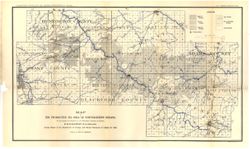
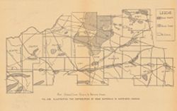
- Topical Subject: Gravel, Geographic Subject: Indiana, Topical Subject: IGS Annual Reports, and Topical Subject: Road materials
- Publisher:
- Indiana. Department of Geology and Natural Resources
- Date Created:
- 1906
- Identifier:
- VAC3073-M-00646
- Genre:
- Thematic maps and Geological maps
- Geographic Location:
- Coordinates: W0873100 W0844800 N0413000 N0403400
- Related URL:
- Catalog URL: https://iucat.iu.edu/catalog/18299084
- Abstract:
- Alternate title: Illustrating the distribution of road materials in northern Indiana. At head of alternate title: Fig. 23. Shows areas of abundant, scarce, a...
- Call Number:
- G4091.H5 1905 .M3
- Caption:
- Imprint: [Indianapolis] : [Indiana Dept. of Geology and Natural Resources], [1906]
- Physical Description:
- Scale: Scale not given. and Dimensions: on sheet 17 x 26 cm
- Alternate Identifier:
- Title Control Number: a18299084 and Alternate ID: 390726IP
- Persistent URL:
- https://purl.dlib.indiana.edu/iudl/images/VAC3073/VAC3073-M-00646
- Provenance:
- 30th Annual Report (1905) / Indiana. Department of Geology and Natural Resources.
-
- Subject:
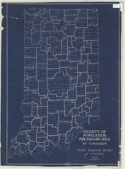
- Geographic Subject: Indiana and Topical Subject: Population density
- Creator:
- Indiana. State Planning Board
- Publisher:
- Indiana. State Planning Board
- Date Created:
- 1936
- Identifier:
- VAC3073-M-00852
- Genre:
- Thematic maps
- Geographic Location:
- Coordinates: W0880700 W0844500 N0414500 N0375200
- Related URL:
- Catalog URL: https://iucat.iu.edu/catalog/4890579
- Abstract:
- Blueprint. "1936."
- Call Number:
- G4091 .E2 1936 .I5
- Caption:
- Imprint: [Indianapolis] : The Board, 1936.
- Physical Description:
- Dimensions: 99 x 70 cm and Scale: 1:500,000
- Alternate Identifier:
- Title Control Number: a4890579
- Persistent URL:
- https://purl.dlib.indiana.edu/iudl/images/VAC3073/VAC3073-M-00852
-
- Subject:
- Geographic Subject: Indiana
- Creator:
- Peale, R. S. (Richard S.)
- Publisher:
- Matthews-Northrup Company , J.N. Matthews Co.
- Date Created:
- 1902
- Identifier:
- VAC3073-M-00880
- Genre:
- Maps
- Geographic Location:
- Coordinates: W0880700 W0844500 N0414500 N0375200
- Related URL:
- Catalog URL: https://iucat.iu.edu/catalog/5166015
- Abstract:
- Shows counties, railroads, and place names. "6.02."
- Call Number:
- G4090 1902 .J586
- Caption:
- Imprint: New York : R.S. Peale, [1902]
- Physical Description:
- Dimensions: 28 x 22 cm and Scale: 1:1,647,369
- Alternate Identifier:
- Title Control Number: a5166015
- Persistent URL:
- https://purl.dlib.indiana.edu/iudl/images/VAC3073/VAC3073-M-00880
-
- Subject:
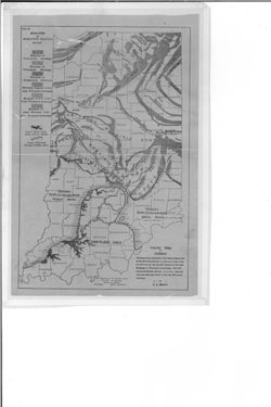
- Topical Subject: Glacial landforms, Topical Subject: Moraines, Topical Subject: Geology, Stratigraphic, and Geographic Subject: Indiana
- Creator:
- Malott, Clyde A.
- Publisher:
- Indiana. Department of Conservation
- Date Created:
- 1919
- Identifier:
- VAC3073-M-00350
- Genre:
- Geological maps
- Geographic Location:
- Coordinates: W0880500 W0844700 N0414500 N0374600
- Related URL:
- Catalog URL: https://iucat.iu.edu/catalog/18454597
- Abstract:
- Shows moraines of Wisconsin glacial stage, former glacial lakes along driftless margins, and glacial waterways through driftless areas. "Showing Glacial...
- Call Number:
- HC107 .I6
- Caption:
- Imprint: [Indianapolis] : Department of Conservation, Division of Geology, State of Indiana, [1922]
- Physical Description:
- Scale: Scale not given. and Dimensions: 30 x 19 cm
- Alternate Identifier:
- Alternate ID: BGE0976BB and Title Control Number: a18454597
- Persistent URL:
- https://purl.dlib.indiana.edu/iudl/images/VAC3073/VAC3073-M-00350
- Provenance:
- Handbook of Indiana geology, part 2 (1922) / by W. N. Logan, E. R. Cumings, C. A. Malott, S. S. Visher, W. M. Tucker, J. R. Reeves.
-
- Subject:
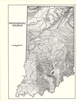
- Geographic Subject: Indiana, Topical Subject: Physiographic provinces, and Topical Subject: Physical geography
- Creator:
- Switzer, J. E. (Jesse Elmer) and Kingsbury, Robert C.
- Publisher:
- Indiana University. Department of Geography
- Date Created:
- 1970
- Identifier:
- VAC3073-M-00819
- Genre:
- Physical maps and Topographic maps
- Geographic Location:
- Coordinates: W0880700 W0844500 N0414500 N0374600
- Related URL:
- Catalog URL: https://iucat.iu.edu/catalog/15938799
- Abstract:
- Relief shown by landform drawing. Shows southern limit of glaciation in Indiana. Originally compiled approximately 1932 by J.E. Switzer, Department of Geolog...
- Call Number:
- G4091.C21 1970 .S96
- Caption:
- Imprint: Bloomington, Indiana : Department of Geography, Indiana University, [1970]
- Physical Description:
- Dimensions: 26 x 18 cm, on sheet 28 x 21 cm and Scale: Approximately 1:1,850,000
- Alternate Identifier:
- Alternate ID: 317383IP and Title Control Number: a15938799
- Persistent URL:
- https://purl.dlib.indiana.edu/iudl/images/VAC3073/VAC3073-M-00819
- Provenance:
- An atlas of Indiana / by Robert C. Kingsbury [1970].
-

- Subject:
- Geographic Subject: Clay County (Ind.), Topical Subject: Coal, Geographic Subject: Putnam County (Ind.), Topical Subject: IGS Annual Reports, Geographic Subj...
- Creator:
- Ashley, Geo. H. (George Hall), 1866-1951, Siebenthal, C. E. (Claude Ellsworth), 1869-1930, and Scovell, J. T. (Josiah Thomas), 1841-
- Publisher:
- Indiana. Department of Geology and Natural Resources
- Date Created:
- 1899
- Identifier:
- VAC3073-M-00899
- Genre:
- Geological maps and Geological cross-sections
- Geographic Location:
- Coordinates: W0873635 W0864028 N0393634 N0390856
- Related URL:
- Catalog URL: https://iucat.iu.edu/catalog/18259650
- Abstract:
- Relief shown by spot heights. Includes map showing coal locations and features, railroads, and quarries as well as vertical cross sections for Dana to Portla...
- Call Number:
- G4093.V5H9 1898 .A84
- Caption:
- Imprint: Indianapolis, Ind. : Wm. B. Burford, [1899]
- Physical Description:
- Scale: Approximately 1:126,720. 2 miles = 1 inch and Dimensions: 48 x 77 cm
- Alternate Identifier:
- Alternate ID: 390726IP and Title Control Number: a18259650
- Persistent URL:
- https://purl.dlib.indiana.edu/iudl/images/VAC3073/VAC3073-M-00899
- Provenance:
- 23rd Annual Report (1898) / Indiana. Department of Geology and Natural Resources.
-
![[Indiana]](https://iiif.uits.iu.edu/iiif/2/0c484n78s%2Ffiles%2F65958835-c3fd-42a1-9953-47d4a5e4e300/full/250,/0/default.jpg)
- Subject:
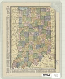
- Geographic Subject: Indiana
- Creator:
- Coffman, Lotus Delta, 1875-1938
- Publisher:
- Coffman, Lotus Delta, 1875-1938
- Date Created:
- 1904
- Identifier:
- VAC3073-M-00976
- Genre:
- Outline maps
- Geographic Location:
- Coordinates: W0880500 W0844700 N0414500 N0374600
- Related URL:
- Catalog URL: https://iucat.iu.edu/catalog/5167204
- Abstract:
- Shows county boundaries. Title supplied by cataloger. Place of publication from U.S. Copyright Office. Catalogue of title entries of books and other articl...
- Call Number:
- G4091 .A1 1904 .C64
- Caption:
- Imprint: [Salem, Ind.?] : Lotus D. Coffman, [1904]
- Physical Description:
- Scale: Scale not given. and Dimensions: 33 x 24 cm
- Alternate Identifier:
- Title Control Number: a5167204
- Persistent URL:
- https://purl.dlib.indiana.edu/iudl/images/VAC3073/VAC3073-M-00976
-
- Subject:
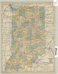
- Geographic Subject: Indiana
- Creator:
- C.S. Hammond & Company
- Publisher:
- C.S. Hammond & Company
- Date Created:
- 1907
- Identifier:
- VAC3073-M-00851
- Genre:
- Maps
- Geographic Location:
- Coordinates: W0880700 W0844500 N0414500 N0375200
- Related URL:
- Catalog URL: https://iucat.iu.edu/catalog/5166890
- Abstract:
- Shows counties, cities and towns by population, and railroads. Includes area and populations statistics and indexes to counties and cities and towns.
- Call Number:
- G4090 1907 .C74
- Caption:
- Imprint: New York : Hammond, [1907]
- Physical Description:
- Dimensions: 27 x 20 cm and Scale: 1:1,600,000
- Alternate Identifier:
- Title Control Number: a5166890
- Persistent URL:
- https://purl.dlib.indiana.edu/iudl/images/VAC3073/VAC3073-M-00851
-
- Subject:
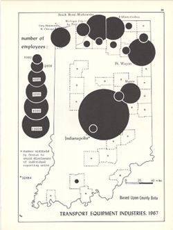
- Topical Subject: Labor supply, Topical Subject: Transportation equipment industry--Employees, and Geographic Subject: Indiana
- Creator:
- Kingsbury, Robert C. and Hollingsworth, John M.
- Publisher:
- Indiana University. Department of Geography
- Date Created:
- 1970
- Identifier:
- VAC3073-M-00620
- Genre:
- Thematic maps
- Geographic Location:
- Coordinates: W0880700 W0844500 N0414500 N0374600
- Related URL:
- Catalog URL: https://iucat.iu.edu/catalog/15951296
- Abstract:
- Graduated symbol map. Shows number of employees by county. Detached from: An atlas of Indiana / by Robert C. Kingsbury , with contributions from John M. H...
- Call Number:
- G4091.G8 1967 .K62
- Caption:
- Imprint: Bloomington, Indiana : Department of Geography, Indiana University, [1970]
- Physical Description:
- Dimensions: 26 x 18 cm, on sheet 28 x 21 cm and Scale: Approximately 1:1,950,000
- Alternate Identifier:
- Alternate ID: 317383IP and Title Control Number: a15951296
- Persistent URL:
- https://purl.dlib.indiana.edu/iudl/images/VAC3073/VAC3073-M-00620
- Provenance:
- An atlas of Indiana / by Robert C. Kingsbury [1970].
