
Search Constraints
You searched for:
Campus
IUB
Remove constraint Campus: IUB
Pages
0-99 pages
Remove constraint Pages: 0-99 pages
Provenance
DMA Topographic Center, Army Map Service Library
Remove constraint Provenance: DMA Topographic Center, Army Map Service Library
« Previous |
1 - 50 of 221
|
Next »
Search Results
-
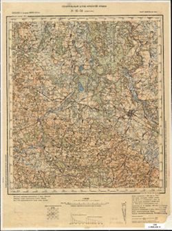
- Description:
- 1903
- Subject:
- Geographic Subject: Smarhon, Topical Subject: Maps, and Topical Subject: Soviet Union
- Publisher:
- Генеральный штаб Красной Армии
- Language:
- Russian
- Date Created:
- 1940
- Identifier:
- VAC9619-004055
- Genre:
- Topographic Maps and Military Maps
- Geographic Location:
- Coordinates: 54.333, 26, 54.667, 26.5
- Related URL:
- Download GeoTIFF: https://drive.google.com/file/d/1Hyh1FTHPh2WfcSA6rFTZ67hecvz2-9cA/view?usp=sharing and Catalog URL: https://iucat.iu.edu/catalog/5020129
- Abstract:
- Modern area represented: Smarhon, Hrodna oblast, Belarus
- Call Number:
- G7000 s100 .S7 sheet N-35-53
- City:
- Сморгонь (Smarhon)
- Copyright Holder:
- No Copyright - United States
- Country:
- СССР (USSR)
- State/Province:
- Белорусская ССР (Byelorussian Soviet Socialist Republic) and Вилейская область (Vileyka oblast)
- Physical Description:
- Scale: 1:100,000
- Persistent URL:
- http://purl.dlib.indiana.edu/iudl/images/VAC9619/VAC9619-004055
- Provenance:
- DMA Topographic Center, Army Map Service Library
-
- Description:
- 1901
- Subject:
- Topical Subject: Maps, Geographic Subject: Utena, and Topical Subject: Soviet Union
- Publisher:
- Генеральный штаб РККА
- Language:
- Russian
- Date Created:
- 1903
- Identifier:
- VAC9619-004018
- Genre:
- Topographic Maps and Military Maps
- Geographic Location:
- Coordinates: 55.333, 25.5, 55.667, 26
- Related URL:
- Download GeoTIFF: https://drive.google.com/file/d/1pEEG0_-uG8tVJDX5J7ToJBZF8UXZ4fwm/view?usp=sharing and Catalog URL: https://iucat.iu.edu/catalog/5020129
- Abstract:
- Modern area represented: Utena, Lithuania
- Call Number:
- G7000 s100 .S7 sheet N-35-16
- City:
- Утена (Utena)
- Copyright Holder:
- No Copyright - United States
- Country:
- Литва (Lithuania) and Польша (Poland)
- Physical Description:
- Scale: 1:100,000
- Persistent URL:
- http://purl.dlib.indiana.edu/iudl/images/VAC9619/VAC9619-004018
- Provenance:
- DMA Topographic Center, Army Map Service Library
-
- Description:
- 1927
- Subject:
- Topical Subject: Maps, Geographic Subject: Tyntsy, and Topical Subject: Soviet Union
- Publisher:
- Управление военных топографов РККА
- Language:
- Russian
- Identifier:
- VAC9619-002272
- Genre:
- Military Maps and Topographic Maps
- Geographic Location:
- Coordinates: 56.3333, 40.5, 56.6667, 41
- Related URL:
- Download GeoTIFF: https://drive.google.com/file/d/102D4vu1uG3HlLnspP2zmEKvXMZnMEkAk/view?usp=sharing and Catalog URL: https://iucat.iu.edu/catalog/5020129
- Abstract:
- Modern area represented: Тынцы (Tyntsy), Vladimirskaya oblast, Russia
- Call Number:
- G7000 s100 .S7 sheet O-37-130
- City:
- Тынцы (Tyntsy)
- Copyright Holder:
- No Copyright - United States
- Country:
- СССР (USSR)
- State/Province:
- РСФСР (RSFSR) and Ивановская область (Ivanovo oblast)
- Physical Description:
- Scale: 1:100,000
- Persistent URL:
- http://purl.dlib.indiana.edu/iudl/images/VAC9619/VAC9619-002272
- Provenance:
- DMA Topographic Center, Army Map Service Library
-

- Description:
- 1926
- Subject:
- Topical Subject: Soviet Union, Geographic Subject: Sirotskiy, and Topical Subject: Maps
- Publisher:
- Генеральный штаб Красной Армии
- Language:
- Russian
- Date Created:
- 1941
- Identifier:
- VAC9619-002461
- Genre:
- Military Maps and Topographic Maps
- Geographic Location:
- Coordinates: 47, 43, 47.333, 43.5
- Related URL:
- Download GeoTIFF: https://drive.google.com/file/d/1lKyxlwfueH8iSqR8tLrAkEEVeuu5mIWT/view?usp=sharing and Catalog URL: https://iucat.iu.edu/catalog/5020129
- Abstract:
- Modern area represented: Sirotskiy, Russia
- Call Number:
- G7000 s100 .S7 sheet L-38-27
- Caption:
- Для служебного пользования
- City:
- Сиротский (Sirotskiy)
- Copyright Holder:
- No Copyright - United States
- Country:
- СССР (USSR)
- State/Province:
- РСФСР (RSFSR) and Ростовская область (Rostov oblast)
- Physical Description:
- Scale: 1:100,000
- Persistent URL:
- http://purl.dlib.indiana.edu/iudl/images/VAC9619/VAC9619-002461
- Provenance:
- DMA Topographic Center, Army Map Service Library
-

- Description:
- 1935
- Subject:
- Topical Subject: Soviet Union, Geographic Subject: Dagestan, Topical Subject: Maps, and Geographic Subject: Chubutla
- Publisher:
- Генеральный штаб Красной Армии
- Language:
- Russian
- Date Created:
- 1942
- Identifier:
- VAC9619-002249
- Genre:
- Topographic Maps and Military Maps
- Geographic Location:
- Coordinates: 44, 46, 44.3333, 46.5
- Related URL:
- Catalog URL: https://iucat.iu.edu/catalog/5020129 and Download GeoTIFF: https://drive.google.com/file/d/1CtOJbTsOR2cKivui8A9rZyUndxVZuweF/view?usp=sharing
- Abstract:
- Modern area represented: Чубутла (Chubutla), Dagestan, Russia
- Call Number:
- G7000 s100 .S7 sheet L-38-141
- Caption:
- Для cлужебного пользования
- City:
- Аул-Чубутла (Aul-Chubutla)
- Copyright Holder:
- No Copyright - United States
- Country:
- СССР (USSR)
- State/Province:
- Кизлярский округ (Kizlyar district), РСФСР (RSFSR), and Орджоникидзевский край (Ordzhonikidze kray)
- Physical Description:
- Scale: 1:100,000
- Persistent URL:
- http://purl.dlib.indiana.edu/iudl/images/VAC9619/VAC9619-002249
- Provenance:
- DMA Topographic Center, Army Map Service Library
-

- Description:
- 1890
- Subject:
- Topical Subject: Maps, Geographic Subject: Merkinė, and Topical Subject: Soviet Union
- Publisher:
- Генеральный штаб Красной Армии
- Language:
- Russian
- Date Created:
- 1940
- Identifier:
- VAC9619-004062
- Genre:
- Military Maps and Topographic Maps
- Geographic Location:
- Coordinates: 54, 24, 54.333, 24.5
- Related URL:
- Download GeoTIFF: https://drive.google.com/file/d/1y93Q-evfnuFOv1Y5G5Dz9TqcZre99-Eq/view?usp=sharing and Catalog URL: https://iucat.iu.edu/catalog/5020129
- Abstract:
- Modern area represented: Merkinė, Lithuania
- Call Number:
- G7000 s100 .S7 sheet N-35-61
- Caption:
- Для служебного пользования
- City:
- Меречь (Merecz)
- Copyright Holder:
- No Copyright - United States
- Country:
- СССР (USSR)
- State/Province:
- Литовская ССР (Lithuanian Soviet Socialist Republic)
- Physical Description:
- Scale: 1:100,000
- Persistent URL:
- http://purl.dlib.indiana.edu/iudl/images/VAC9619/VAC9619-004062
- Provenance:
- DMA Topographic Center, Army Map Service Library
-
- Description:
- 1940
- Subject:
- Geographic Subject: Pavlovskaya, Topical Subject: Maps, and Topical Subject: Soviet Union
- Publisher:
- Генеральный штаб Красной Армии
- Language:
- Russian
- Date Created:
- 1941
- Identifier:
- VAC9619-002330
- Genre:
- Topographic Maps and Military Maps
- Geographic Location:
- Coordinates: 46, 39.5, 46.3333, 40
- Related URL:
- Download GeoTIFF: https://drive.google.com/file/d/1xbqEApJ5hSLMPVxfU-oodDof-dkkXh20/view?usp=sharing and Catalog URL: https://iucat.iu.edu/catalog/5020129
- Abstract:
- Modern area represented: Pavlovskaya, Russia
- Call Number:
- G7000 s100 .S7 sheet L-37-68
- Caption:
- Для служебного пользования
- City:
- Павловская (Pavlovskaya)
- Copyright Holder:
- No Copyright - United States
- Country:
- СССР (USSR)
- State/Province:
- Краснодарский край (Krasnodar kray) and РСФСР (RSFSR)
- Physical Description:
- Scale: 1:100,000
- Persistent URL:
- http://purl.dlib.indiana.edu/iudl/images/VAC9619/VAC9619-002330
- Provenance:
- DMA Topographic Center, Army Map Service Library
-
- Description:
- 1936
- Subject:
- Topical Subject: Maps, Geographic Subject: Stepnaya, and Topical Subject: Soviet Union
- Publisher:
- Главное управление геодезии и картографии при СНК СССР
- Language:
- Russian
- Date Created:
- 1941
- Identifier:
- VAC9619-002337
- Genre:
- Topographic Maps and Military Maps
- Geographic Location:
- Coordinates: 45.667, 38, 46, 38.5
- Related URL:
- Catalog URL: https://iucat.iu.edu/catalog/5020129 and Download GeoTIFF: https://drive.google.com/file/d/1JbpHtvnICqALvD_ZX180f74-4Ca2Qrxr/view?usp=sharing
- Abstract:
- Modern area represented: Stepnaya, Russia
- Call Number:
- G7000 s100 .S7 sheet L-37-77
- Caption:
- Для служебного пользования
- City:
- Степная (Stepnaya)
- Copyright Holder:
- No Copyright - United States
- Country:
- СССР (USSR)
- State/Province:
- Краснодарский край (Krasnodar kray) and РСФСР (RSFSR)
- Physical Description:
- Scale: 1:100,000
- Persistent URL:
- http://purl.dlib.indiana.edu/iudl/images/VAC9619/VAC9619-002337
- Provenance:
- DMA Topographic Center, Army Map Service Library
-
- Description:
- 1910
- Subject:
- Topical Subject: Maps, Geographic Subject: Myszyniec, and Topical Subject: Soviet Union
- Publisher:
- Генеральный штаб РККА
- Language:
- Russian
- Date Created:
- 1936
- Identifier:
- VAC9619-003958
- Genre:
- Military Maps and Topographic Maps
- Geographic Location:
- Coordinates: 53.333, 21, 53.667, 21.5
- Related URL:
- Download GeoTIFF: https://drive.google.com/file/d/1B6ZEwsNeUZ6BWE_--ZMSM0vuCXUzT4tV/view?usp=sharing and Catalog URL: https://iucat.iu.edu/catalog/5020129
- Abstract:
- Modern area represented: Myszyniec, Mazovia, Poland
- Call Number:
- G7000 s100 .S7 sheet N-34-91
- City:
- Мышинец (Myszyniec)
- Copyright Holder:
- No Copyright - United States
- Country:
- Германия (Germany)
- State/Province:
- Область государственных интересов Германии (Region of German state interests)
- Physical Description:
- Scale: 1:100,000
- Persistent URL:
- http://purl.dlib.indiana.edu/iudl/images/VAC9619/VAC9619-003958
- Provenance:
- DMA Topographic Center, Army Map Service Library
-

- Description:
- 1890
- Subject:
- Topical Subject: Soviet Union, Topical Subject: Maps, and Geographic Subject: Slonim
- Publisher:
- Генеральный штаб Красной Армии
- Language:
- Russian
- Date Created:
- 1940
- Identifier:
- VAC9619-004100
- Genre:
- Military Maps and Topographic Maps
- Geographic Location:
- Coordinates: 53, 25, 53.333, 25.5
- Related URL:
- Download GeoTIFF: https://drive.google.com/file/d/11uIlcuAi2jRjN2zbDtSfPdBrUot13QKy/view?usp=sharing and Catalog URL: https://iucat.iu.edu/catalog/5020129
- Abstract:
- Modern area represented: Slonim, Belarus
- Call Number:
- G7000 s100 .S7 sheet N-35-99
- City:
- Слоним (Slonim)
- Copyright Holder:
- No Copyright - United States
- Country:
- СССР (USSR)
- State/Province:
- Белорусская ССР (Byelorussian Soviet Socialist Republic) and Барановичская область (Baranavichy oblast)
- Physical Description:
- Scale: 1:100,000
- Persistent URL:
- http://purl.dlib.indiana.edu/iudl/images/VAC9619/VAC9619-004100
- Provenance:
- DMA Topographic Center, Army Map Service Library
-
- Description:
- 1936
- Subject:
- Topical Subject: Soviet Union, Topical Subject: Maps, and Geographic Subject: Svislach
- Publisher:
- Управление военных топографов РККА
- Language:
- Russian
- Identifier:
- VAC9619-004094
- Genre:
- Topographic Maps and Military Maps
- Geographic Location:
- Coordinates: 53.333, 28.5, 53.667, 29
- Related URL:
- Download GeoTIFF: https://drive.google.com/file/d/1wKKzZhgv9Dr2ahNLD1JmLpBLB1twGSqm/view?usp=sharing and Catalog URL: https://iucat.iu.edu/catalog/5020129
- Abstract:
- Modern area represented: Svislach, Belarus
- Call Number:
- G7000 s100 .S7 sheet N-35-94
- Caption:
- Не подлежит оглашению
- City:
- Свислочь (Svislach)
- Copyright Holder:
- No Copyright - United States
- Country:
- СССР (USSR)
- State/Province:
- Белорусская ССР (Byelorussian Soviet Socialist Republic)
- Physical Description:
- Scale: 1:100,000
- Persistent URL:
- http://purl.dlib.indiana.edu/iudl/images/VAC9619/VAC9619-004094
- Provenance:
- DMA Topographic Center, Army Map Service Library
-
- Description:
- 1940
- Subject:
- Topical Subject: Soviet Union, Geographic Subject: Leningradskaya, and Topical Subject: Maps
- Publisher:
- Генеральный штаб Красной Армии
- Language:
- Russian
- Date Created:
- 1941
- Identifier:
- VAC9619-002329
- Genre:
- Military Maps and Topographic Maps
- Geographic Location:
- Coordinates: 46, 39, 46.3333, 39.5
- Related URL:
- Download GeoTIFF: https://drive.google.com/file/d/1O9ZH2ptxPJJ9cDyD-JH5mXSQdZcyF-6n/view?usp=sharing and Catalog URL: https://iucat.iu.edu/catalog/5020129
- Abstract:
- Modern area represented: Leningradskaya, Russia
- Call Number:
- G7000 s100 .S7 sheet L-37-67
- Caption:
- Для служебного пользования
- City:
- Ленинградская (Leningradskaya)
- Copyright Holder:
- No Copyright - United States
- Country:
- СССР (USSR)
- State/Province:
- Краснодарский край (Krasnodar kray) and РСФСР (RSFSR)
- Physical Description:
- Scale: 1:100,000
- Persistent URL:
- http://purl.dlib.indiana.edu/iudl/images/VAC9619/VAC9619-002329
- Provenance:
- DMA Topographic Center, Army Map Service Library
-
- Description:
- 1927
- Subject:
- Topical Subject: Maps, Topical Subject: Soviet Union, and Geographic Subject: Zapadnaya Dvina
- Publisher:
- Генеральный штаб Красной Армии
- Language:
- Russian
- Date Created:
- 1941
- Identifier:
- VAC9619-002233
- Genre:
- Military Maps and Topographic Maps
- Geographic Location:
- Coordinates: 56, 32, 56.3333, 32.5
- Related URL:
- Catalog URL: https://iucat.iu.edu/catalog/5020129 and Download GeoTIFF: https://drive.google.com/file/d/1ilppakufLs2qQPDjQwcVhMDRRILKyH-b/view?usp=sharing
- Abstract:
- Modern area represented: Западная Двина (Zapadnaya Dvina), Tverskaya oblast, Russia
- Call Number:
- G7000 s100 .S7 sheet O-36-137
- Caption:
- Captured map
- City:
- Западная Двина (Zapadnaya Dvina)
- Copyright Holder:
- No Copyright - United States
- Country:
- СССР (USSR)
- State/Province:
- Калининская область (Kalinin oblast), Смоленская область (Smolensk oblast), and РСФСР (RSFSR)
- Physical Description:
- Scale: 1:100,000
- Persistent URL:
- http://purl.dlib.indiana.edu/iudl/images/VAC9619/VAC9619-002233
- Provenance:
- DMA Topographic Center, Army Map Service Library
-
- Description:
- 1938
- Subject:
- Topical Subject: Soviet Union, Geographic Subject: Zaraysk, and Topical Subject: Maps
- Publisher:
- Генеральный штаб Красной Армии
- Language:
- Russian
- Date Created:
- 1941
- Identifier:
- VAC9619-003102
- Genre:
- Military Maps and Topographic Maps
- Geographic Location:
- Coordinates: 54.667, 38.5, 55, 39
- Related URL:
- Catalog URL: https://iucat.iu.edu/catalog/5020129 and Download GeoTIFF: https://drive.google.com/file/d/1CmYyVQOnWjiCDq9ktmzhtJHliBIrO_dX/view?usp=sharing
- Abstract:
- Modern area represented: Zaraysk, Russia
- Call Number:
- G7000 s100 .S7 sheet N-37-42
- Caption:
- Для служебного пользования
- City:
- Зарайск (Zaraysk)
- Copyright Holder:
- No Copyright - United States
- Country:
- СССР (USSR)
- State/Province:
- Московская область (Moscow oblast) and РСФСР (RSFSR)
- Physical Description:
- Scale: 1:100,000
- Persistent URL:
- http://purl.dlib.indiana.edu/iudl/images/VAC9619/VAC9619-003102
- Provenance:
- DMA Topographic Center, Army Map Service Library
-
- Description:
- 1939
- Subject:
- Geographic Subject: Kamyzyak, Topical Subject: Maps, Topical Subject: Soviet Union, and Geographic Subject: Astrakhan Oblast
- Publisher:
- Наркомрыбпром Главрыбвод
- Language:
- Russian
- Date Created:
- 1940
- Identifier:
- VAC9619-002256
- Genre:
- Military Maps and Topographic Maps
- Geographic Location:
- Coordinates: 46, 48, 46.3333, 48.5
- Related URL:
- Catalog URL: https://iucat.iu.edu/catalog/5020129 and Download GeoTIFF: https://drive.google.com/file/d/1COuEZimX0zDKPsy-a9vlykqgrNjh2Jla/view?usp=sharing
- Abstract:
- Modern area represented: Камызяк (Kamyzyak), Astrakhan Oblast, Russia
- Call Number:
- G7000 s100 .S7 sheet L-39-61
- Caption:
- Рабочий оттиск. Бесплатно. Временное Издание. Для внутреннего использования.
- City:
- Камызяк (Kamyzyak)
- Copyright Holder:
- No Copyright - United States
- Country:
- СССР (USSR)
- State/Province:
- РСФСР (RSFSR) and Сталинградская область (Stalingrad oblast)
- Physical Description:
- Scale: 1:100,000
- Persistent URL:
- http://purl.dlib.indiana.edu/iudl/images/VAC9619/VAC9619-002256
- Provenance:
- DMA Topographic Center, Army Map Service Library
-
- Description:
- 1916
- Subject:
- Geographic Subject: Janowo, Topical Subject: Maps, and Topical Subject: Soviet Union
- Publisher:
- Генеральный штаб РККА
- Language:
- Russian
- Date Created:
- 1936
- Identifier:
- VAC9619-003959
- Genre:
- Topographic Maps and Military Maps
- Geographic Location:
- Coordinates: 53.333, 21.5, 53.667, 22
- Related URL:
- Catalog URL: https://iucat.iu.edu/catalog/5020129 and Download GeoTIFF: https://drive.google.com/file/d/1V9_BtRhfFGWhUMbvWGMSthlnHu_vi1pv/view?usp=sharing
- Abstract:
- Modern area represented: Janowo, Warmia-Masuria, Poland
- Call Number:
- G7000 s100 .S7 sheet N-34-92
- City:
- Иоганнисбург (Johannisberg)
- Copyright Holder:
- No Copyright - United States
- Country:
- СССР (USSR) and Германия (Germany)
- State/Province:
- Белорусская ССР (Byelorussian Soviet Socialist Republic), Область государственных интересов Германии (Region of German state interests), and Белостокская обл...
- Physical Description:
- Scale: 1:100,000
- Persistent URL:
- http://purl.dlib.indiana.edu/iudl/images/VAC9619/VAC9619-003959
- Provenance:
- DMA Topographic Center, Army Map Service Library
-
- Description:
- 1939
- Subject:
- Geographic Subject: Surovikino, Topical Subject: Soviet Union, and Topical Subject: Maps
- Publisher:
- Генеральный штаб Красной Армии
- Language:
- Russian
- Date Created:
- 1941
- Identifier:
- VAC9619-003434
- Genre:
- Military Maps and Topographic Maps
- Geographic Location:
- Coordinates: 48.333, 42.5, 48.667, 43
- Related URL:
- Download GeoTIFF: https://drive.google.com/file/d/1IklMCz8LqY7v79fI3kROuDDC6V5cGWZK/view?usp=sharing and Catalog URL: https://iucat.iu.edu/catalog/5020129
- Abstract:
- Modern area represented: Surovikino, Volgograd oblast, Russia
- Call Number:
- G7000 s100 .S7 sheet M-38-122
- Caption:
- Для служебного пользования
- City:
- Суровикино (Surovikino)
- Copyright Holder:
- No Copyright - United States
- Country:
- СССР (USSR)
- State/Province:
- Сталинградская область (Stalingrad oblast), РСФСР (RSFSR), and Ростовская область (Rostov oblast)
- Physical Description:
- Scale: 1:100,000
- Persistent URL:
- http://purl.dlib.indiana.edu/iudl/images/VAC9619/VAC9619-003434
- Provenance:
- DMA Topographic Center, Army Map Service Library
-
- Subject:
- Topical Subject: Soviet Union, Geographic Subject: Yaroslavl, and Topical Subject: Maps
- Publisher:
- Генеральный штаб Красной Армии
- Language:
- Russian
- Date Created:
- 1941
- Identifier:
- VAC9619-002239
- Genre:
- Topographic Maps and Military Maps
- Geographic Location:
- Coordinates: 57.3333, 39.5, 57.6667, 40
- Related URL:
- Catalog URL: https://iucat.iu.edu/catalog/5020129 and Download GeoTIFF: https://drive.google.com/file/d/1s1X2JX-UlHkHlKMosuECdWUBwvDsqFQ1/view?usp=sharing
- Abstract:
- Modern area represented: Yaroslavl, Yaroslavl oblast, Russia
- Call Number:
- G7000 s100 .S7 sheet O-37-92
- Caption:
- Для служебного пользования,Captured map
- City:
- Ярославль (Yaroslavl')
- Copyright Holder:
- No Copyright - United States
- Country:
- СССР (USSR)
- State/Province:
- Ярославская область (Yaroslavl oblast) and РСФСР (RSFSR)
- Physical Description:
- Scale: 1:100,000
- Persistent URL:
- http://purl.dlib.indiana.edu/iudl/images/VAC9619/VAC9619-002239
- Provenance:
- DMA Topographic Center, Army Map Service Library
-
- Description:
- 1925
- Subject:
- Topical Subject: Soviet Union, Topical Subject: Maps, and Geographic Subject: Severnaya
- Publisher:
- Геодезический комитет ВСНХ-СССР
- Language:
- Russian
- Date Created:
- 1927
- Identifier:
- VAC9619-002301
- Genre:
- Military Maps and Topographic Maps
- Geographic Location:
- Coordinates: 58, 60, 58.3333, 60.5
- Related URL:
- Download GeoTIFF: https://drive.google.com/file/d/1o_vAe_BRYbHzSAeCwHc6Fvpp9aaR2qCk/view?usp=sharing and Catalog URL: https://iucat.iu.edu/catalog/5020129
- Abstract:
- Currently: Sverdlovskaya oblast, Verkhnesaldinskij rayon
- Call Number:
- G7000 s100 .S7 sheet O-41-61
- City:
- Северная (Severnaya)
- Copyright Holder:
- No Copyright - United States
- Country:
- СССР (USSR)
- State/Province:
- Тагильский округ (Tagilsky district) and Уральская область (Ural oblast)
- Physical Description:
- Scale: 1:100,000
- Persistent URL:
- http://purl.dlib.indiana.edu/iudl/images/VAC9619/VAC9619-002301
- Provenance:
- DMA Topographic Center, Army Map Service Library
-
- Description:
- 1880
- Subject:
- Geographic Subject: Gmina Jadów, Topical Subject: Soviet Union, and Topical Subject: Maps
- Publisher:
- Генеральный штаб Красной Армии
- Language:
- Russian
- Date Created:
- 1940
- Identifier:
- VAC9619-003991
- Genre:
- Topographic Maps and Military Maps
- Geographic Location:
- Coordinates: 52.333, 21.5, 52.667, 22
- Related URL:
- Download GeoTIFF: https://drive.google.com/file/d/1mtSm9PaMfrTfFHwbr9CyBuoRcAWPtvuV/view?usp=sharing and Catalog URL: https://iucat.iu.edu/catalog/5020129
- Abstract:
- Modern area represented: Gmina Jadów, Masovian Voivodeship, Poland
- Call Number:
- G7000 s100 .S7 sheet N-34-128
- City:
- Ядув (Jadów)
- Copyright Holder:
- No Copyright - United States
- State/Province:
- Область государственных интересов Германии (Region of German state interests)
- Physical Description:
- Scale: 1:100,000
- Persistent URL:
- http://purl.dlib.indiana.edu/iudl/images/VAC9619/VAC9619-003991
- Provenance:
- DMA Topographic Center, Army Map Service Library
-
- Description:
- 1928
- Subject:
- Topical Subject: Soviet Union, Geographic Subject: Orlovskiy, and Topical Subject: Maps
- Publisher:
- Генеральный штаб Красной Армии
- Language:
- Russian
- Date Created:
- 1941
- Identifier:
- VAC9619-002467
- Genre:
- Topographic Maps and Military Maps
- Geographic Location:
- Coordinates: 46.667, 42, 47, 42.5
- Related URL:
- Download GeoTIFF: https://drive.google.com/file/d/1A5W_rrMYJa6yA7Ti1dQxHa_LjP1eK3E6/view?usp=sharing and Catalog URL: https://iucat.iu.edu/catalog/5020129
- Abstract:
- Modern area represented: Orlovskiy, Russia
- Call Number:
- G7000 s100 .S7 sheet L-38-37
- Caption:
- Для служебного пользования
- City:
- Орловская (Orlovskaya)
- Copyright Holder:
- No Copyright - United States
- Country:
- СССР (USSR)
- State/Province:
- Ростовская область (Rostov oblast) and РСФСР (RSFSR)
- Physical Description:
- Scale: 1:100,000
- Persistent URL:
- http://purl.dlib.indiana.edu/iudl/images/VAC9619/VAC9619-002467
- Provenance:
- DMA Topographic Center, Army Map Service Library
-
- Subject:
- Topical Subject: Maps, Topical Subject: Soviet Union, and Geographic Subject: Komsomol'sk
- Publisher:
- Генеральный штаб Красной Армии
- Language:
- Russian
- Date Created:
- 1941
- Identifier:
- VAC9619-002260
- Genre:
- Military Maps and Topographic Maps
- Geographic Location:
- Coordinates: 57, 40, 57.3333, 40.5
- Related URL:
- Catalog URL: https://iucat.iu.edu/catalog/5020129 and Download GeoTIFF: https://drive.google.com/file/d/14tRLuYnJAQUsHpoXw8ZLFqoMR0eBn57k/view?usp=sharing
- Abstract:
- Modern area represented: Комсомольск (Komsomol'sk), Ivanovskaya oblast, Russia
- Call Number:
- G7000 s100 .S7 sheet O-37-105
- City:
- Комсомольск (Komsomol'sk)
- Copyright Holder:
- No Copyright - United States
- Country:
- СССР (USSR)
- State/Province:
- РСФСР (RSFSR), Ярославская область (Yaroslavl oblast), and Ивановская область (Ivanovo oblast)
- Physical Description:
- Scale: 1:100,000
- Persistent URL:
- http://purl.dlib.indiana.edu/iudl/images/VAC9619/VAC9619-002260
- Provenance:
- DMA Topographic Center, Army Map Service Library
-
- Subject:
- Topical Subject: Soviet Union, Geographic Subject: Chernava, and Topical Subject: Maps
- Publisher:
- Генеральный штаб Красной Армии
- Language:
- Russian
- Date Created:
- 1941
- Identifier:
- VAC9619-003153
- Genre:
- Military Maps and Topographic Maps
- Geographic Location:
- Coordinates: 53.333, 39, 53.667, 39.5
- Related URL:
- Catalog URL: https://iucat.iu.edu/catalog/5020129 and Download GeoTIFF: https://drive.google.com/file/d/1QNxBcZk8CQwKnsyw_o-EnjLO5_KxuP57/view?usp=sharing
- Abstract:
- Modern area represented: Chernava, Russia
- Call Number:
- G7000 s100 .S7 sheet N-37-91
- City:
- Чернава (Chernava)
- Copyright Holder:
- No Copyright - United States
- Country:
- СССР (USSR)
- State/Province:
- РСФСР (RSFSR) and Рязанская область (Ryazan oblast)
- Physical Description:
- Scale: 1:100,000
- Persistent URL:
- http://purl.dlib.indiana.edu/iudl/images/VAC9619/VAC9619-003153
- Provenance:
- DMA Topographic Center, Army Map Service Library
-
- Description:
- 1893
- Subject:
- Topical Subject: Maps, Topical Subject: Soviet Union, and Geographic Subject: Jonava
- Publisher:
- Генеральный штаб РККА
- Language:
- Russian
- Date Created:
- 1932
- Identifier:
- VAC9619-004028
- Genre:
- Military Maps and Topographic Maps
- Geographic Location:
- Coordinates: 55, 24, 55.333, 24.5
- Related URL:
- Catalog URL: https://iucat.iu.edu/catalog/5020129 and Download GeoTIFF: https://drive.google.com/file/d/1JvGl1RJM5BUAjk9eFNYkYyBPV_ejY9-u/view?usp=sharing
- Abstract:
- Modern area represented: Jonava, Lithuania
- Call Number:
- G7000 s100 .S7 sheet N-35-25
- City:
- Йонава (Jonava)
- Copyright Holder:
- No Copyright - United States
- Country:
- Литва (Lithuania)
- Physical Description:
- Scale: 1:100,000
- Persistent URL:
- http://purl.dlib.indiana.edu/iudl/images/VAC9619/VAC9619-004028
- Provenance:
- DMA Topographic Center, Army Map Service Library
-
- Description:
- 1906
- Subject:
- Geographic Subject: Kwidzyn, Topical Subject: Maps, and Topical Subject: Soviet Union
- Publisher:
- Генеральный штаб Красной Армии
- Language:
- Russian
- Date Created:
- 1940
- Identifier:
- VAC9619-003942
- Genre:
- Military Maps and Topographic Maps
- Geographic Location:
- Coordinates: 53.667, 18.5, 54, 19
- Related URL:
- Catalog URL: https://iucat.iu.edu/catalog/5020129 and Download GeoTIFF: https://drive.google.com/file/d/1-5kDJDDNJLlI47BNm9MrRQ7Mg5I3rMnI/view?usp=sharing
- Abstract:
- Modern area represented: Kwidzyn, Pomeranian voivodeship, Poland
- Call Number:
- G7000 s100 .S7 sheet N-34-74
- City:
- Мариенвердер (Marienwerder)
- Copyright Holder:
- No Copyright - United States
- Country:
- Германия (Germany)
- Physical Description:
- Scale: 1:100,000
- Persistent URL:
- http://purl.dlib.indiana.edu/iudl/images/VAC9619/VAC9619-003942
- Provenance:
- DMA Topographic Center, Army Map Service Library
-
- Description:
- 1931
- Subject:
- Topical Subject: Soviet Union, Topical Subject: Maps, and Geographic Subject: Barun
- Publisher:
- Генеральный штаб Красной Армии
- Language:
- Russian
- Date Created:
- 1942
- Identifier:
- VAC9619-002457
- Genre:
- Military Maps and Topographic Maps
- Geographic Location:
- Coordinates: 47.333, 45.5, 47.667, 46
- Related URL:
- Download GeoTIFF: https://drive.google.com/file/d/1ZhUnzUsUyv-giIC_768gciWJUl90Aqqu/view?usp=sharing and Catalog URL: https://iucat.iu.edu/catalog/5020129
- Abstract:
- Modern area represented: Barun, Kalmykiya Republic, Russia
- Call Number:
- G7000 s100 .S7 sheet L-38-20
- Caption:
- Для служебного пользования
- City:
- Баруны (Baruny)
- Copyright Holder:
- No Copyright - United States
- Country:
- СССР (USSR)
- State/Province:
- РСФСР (RSFSR), Сталинградская область (Stalingrad oblast), and Калмыцкая АССР (Kalmyk Autonomous Soviet Socialist Republic)
- Physical Description:
- Scale: 1:100,000
- Persistent URL:
- http://purl.dlib.indiana.edu/iudl/images/VAC9619/VAC9619-002457
- Provenance:
- DMA Topographic Center, Army Map Service Library
-
- Description:
- 1926
- Subject:
- Topical Subject: Soviet Union, Topical Subject: Maps, and Geographic Subject: Rostov
- Publisher:
- Главное управление геодезии и картографии при СНК СССР
- Language:
- Russian
- Date Created:
- 1941
- Identifier:
- VAC9619-002286
- Genre:
- Topographic Maps and Military Maps
- Geographic Location:
- Coordinates: 47, 39.5, 47.3333, 40
- Related URL:
- Catalog URL: https://iucat.iu.edu/catalog/5020129 and Download GeoTIFF: https://drive.google.com/file/d/1XcqLQR-DzZL4b2V2aY4UGhly62ywbl77/view?usp=sharing
- Abstract:
- Modern area represented: Rostov, Russia
- Call Number:
- G7000 s100 .S7 sheet L-37-32
- Caption:
- Для служебного пользования
- City:
- Ростов (Rostov)
- Copyright Holder:
- No Copyright - United States
- Country:
- СССР (USSR)
- State/Province:
- Ростовская область (Rostov oblast) and РСФСР (RSFSR)
- Physical Description:
- Scale: 1:100,000
- Persistent URL:
- http://purl.dlib.indiana.edu/iudl/images/VAC9619/VAC9619-002286
- Provenance:
- DMA Topographic Center, Army Map Service Library
-
- Subject:
- Topical Subject: Maps and Topical Subject: Soviet Union
- Language:
- Russian
- Identifier:
- VAC9619-003978
- Genre:
- Military Maps and Topographic Maps
- Geographic Location:
- Coordinates: 52.667, 20.5, 53, 21
- Related URL:
- Download GeoTIFF: https://drive.google.com/file/d/1byNYsgEkmuztOdECHO3onJgvlMxhKB4s/view?usp=sharing and Catalog URL: https://iucat.iu.edu/catalog/5020129
- Abstract:
- Modern area represented: Ciechanow, Masovian Voivodeship, Poland
- Call Number:
- G7000 s100 .S7 sheet N-34-114
- Copyright Holder:
- No Copyright - United States
- Physical Description:
- Scale: 1:100,000
- Persistent URL:
- http://purl.dlib.indiana.edu/iudl/images/VAC9619/VAC9619-003978
- Provenance:
- DMA Topographic Center, Army Map Service Library
-
- Description:
- 1939
- Subject:
- Topical Subject: Maps, Geographic Subject: Novoyuryevo, and Topical Subject: Soviet Union
- Publisher:
- Главное управление геодезии и картографии при СНК СССР
- Language:
- Russian
- Date Created:
- 1941
- Identifier:
- VAC9619-003155
- Genre:
- Topographic Maps and Military Maps
- Geographic Location:
- Coordinates: 53.333, 40.5, 53.667, 41
- Related URL:
- Catalog URL: https://iucat.iu.edu/catalog/5020129 and Download GeoTIFF: https://drive.google.com/file/d/1MFnYn_pEKen3UiH6Y-od_0ekRDE1T3j-/view?usp=sharing
- Abstract:
- Modern area represented: Novoyuryevo, Russia
- Call Number:
- G7000 s100 .S7 sheet N-37-94
- Caption:
- Captured map
- City:
- Новоюрьево (Novoyuryevo)
- Copyright Holder:
- No Copyright - United States
- Country:
- СССР (USSR)
- State/Province:
- Тамбовская область (Tambov oblast), Рязанская область (Ryazan oblast), and РСФСР (RSFSR)
- Physical Description:
- Scale: 1:100,000
- Persistent URL:
- http://purl.dlib.indiana.edu/iudl/images/VAC9619/VAC9619-003155
- Provenance:
- DMA Topographic Center, Army Map Service Library
-
- Description:
- 1940
- Subject:
- Geographic Subject: Ivanovskoye, Topical Subject: Soviet Union, and Topical Subject: Maps
- Publisher:
- Генеральный штаб Красной Армии
- Language:
- Russian
- Date Created:
- 1941
- Identifier:
- VAC9619-003156
- Genre:
- Military Maps and Topographic Maps
- Geographic Location:
- Coordinates: 53, 36, 53.333, 36.5
- Related URL:
- Catalog URL: https://iucat.iu.edu/catalog/5020129 and Download GeoTIFF: https://drive.google.com/file/d/11YycTgTZEbjbwLW7JyrboHryt6Mb57Bd/view?usp=sharing
- Abstract:
- Modern area represented: Ивановское (Ivanovskoye), Orlovskaya oblast, Russia
- Call Number:
- G7000 s100 .S7 sheet N-37-97
- Caption:
- Captured map
- City:
- Ивановская Оптуха (Ivanovskaya Optukha)
- Copyright Holder:
- No Copyright - United States
- Country:
- СССР (USSR)
- State/Province:
- РСФСР (RSFSR) and Орловская область (Oryol oblast)
- Physical Description:
- Scale: 1:100,000
- Persistent URL:
- http://purl.dlib.indiana.edu/iudl/images/VAC9619/VAC9619-003156
- Provenance:
- DMA Topographic Center, Army Map Service Library
-

- Description:
- 1891
- Subject:
- Topical Subject: Soviet Union, Topical Subject: Maps, and Geographic Subject: Lentvaris
- Publisher:
- Генеральный штаб Красной Армии
- Language:
- Russian
- Date Created:
- 1940
- Identifier:
- VAC9619-004053
- Genre:
- Military Maps and Topographic Maps
- Geographic Location:
- Coordinates: 54.333, 25, 54.667, 25.5
- Related URL:
- Catalog URL: https://iucat.iu.edu/catalog/5020129 and Download GeoTIFF: https://drive.google.com/file/d/1pGDy3t6VgddIj8je6N5NWJd-o0jXgLYB/view?usp=sharing
- Abstract:
- Modern area represented: Lentvaris, Lithuania
- Call Number:
- G7000 s100 .S7 sheet N-35-51
- City:
- Ландворово (Landwarów)
- Copyright Holder:
- No Copyright - United States
- Country:
- СССР (USSR)
- State/Province:
- Белорусская ССР (Byelorussian Soviet Socialist Republic), Барановичская область (Baranavichy oblast), and Литовская ССР (Lithuanian Soviet Socialist Republic)
- Physical Description:
- Scale: 1:100,000
- Persistent URL:
- http://purl.dlib.indiana.edu/iudl/images/VAC9619/VAC9619-004053
- Provenance:
- DMA Topographic Center, Army Map Service Library
-
- Description:
- 1931
- Subject:
- Topical Subject: Soviet Union, Topical Subject: Maps, and Geographic Subject: Zhytnavichy
- Publisher:
- Генеральный штаб РККА
- Language:
- Russian
- Identifier:
- VAC9619-004141
- Genre:
- Military Maps and Topographic Maps
- Geographic Location:
- Coordinates: 52, 27.5, 52.333, 28
- Related URL:
- Download GeoTIFF: https://drive.google.com/file/d/1TRa3FrvHrlTcoOqC7Zb0okd9Jr5kSmlw/view?usp=sharing and Catalog URL: https://iucat.iu.edu/catalog/5020129
- Abstract:
- Modern area represented: Zhytnavichy, Brest oblast, Belarus
- Call Number:
- G7000 s100 .S7 sheet N-35-140
- Caption:
- Не подлежит оглашению
- City:
- Житновичи (Zhytnavichy)
- Copyright Holder:
- No Copyright - United States
- Country:
- СССР (USSR) and Польша (Poland)
- State/Province:
- Белорусская ССР (Byelorussian Soviet Socialist Republic)
- Physical Description:
- Scale: 1:100,000
- Persistent URL:
- http://purl.dlib.indiana.edu/iudl/images/VAC9619/VAC9619-004141
- Provenance:
- DMA Topographic Center, Army Map Service Library
-
- Subject:
- Topical Subject: Soviet Union, Topical Subject: Maps, and Geographic Subject: Muyezerskiy
- Language:
- Russian
- Identifier:
- VAC9619-002470
- Genre:
- Military Maps and Topographic Maps
- Geographic Location:
- Coordinates: 63.667, 31.5, 64, 32
- Related URL:
- Download GeoTIFF: https://drive.google.com/file/d/12_y9sfFp1iAD4SM0rS5CX4Q_JCULa4qp/view?usp=sharing and Catalog URL: https://iucat.iu.edu/catalog/5020129
- Abstract:
- Modern area represented: Муезерский (Muyezerskiy), Republic of Karelia, Russia
- Call Number:
- G7000 s100 .S7 sheet P-36-4
- Copyright Holder:
- No Copyright - United States
- Physical Description:
- Scale: 1:100,000
- Persistent URL:
- http://purl.dlib.indiana.edu/iudl/images/VAC9619/VAC9619-002470
- Provenance:
- DMA Topographic Center, Army Map Service Library
-
- Description:
- 1921
- Subject:
- Topical Subject: Maps, Topical Subject: Soviet Union, and Geographic Subject: Pomeranian Voivodeship
- Publisher:
- Генеральный штаб РККА
- Language:
- Russian
- Date Created:
- 1940
- Identifier:
- VAC9619-003869
- Genre:
- Topographic Maps and Military Maps
- Geographic Location:
- Coordinates: 53.667, 17, 54, 17.5
- Related URL:
- Download GeoTIFF: https://drive.google.com/file/d/1ECQb8yIcYW04beF4Fx_4EfgbRIo6n1fH/view?usp=sharing and Catalog URL: https://iucat.iu.edu/catalog/5020129
- Abstract:
- Modern area represented: Pomeranian Voivodeship, Poland
- Call Number:
- G7000 s100 .S7 sheet N-33-83
- City:
- Прехлау (Priechlau)
- Copyright Holder:
- No Copyright - United States
- Country:
- Германия (Germany)
- Physical Description:
- Scale: 1:100,000
- Persistent URL:
- http://purl.dlib.indiana.edu/iudl/images/VAC9619/VAC9619-003869
- Provenance:
- DMA Topographic Center, Army Map Service Library
-
- Description:
- 1928
- Subject:
- Topical Subject: Maps, Geographic Subject: Verkhnegnutov, and Topical Subject: Soviet Union
- Publisher:
- Генеральный штаб Красной Армии
- Language:
- Russian
- Date Created:
- 1941
- Identifier:
- VAC9619-003439
- Genre:
- Topographic Maps and Military Maps
- Geographic Location:
- Coordinates: 48, 42, 48.333, 42.5
- Related URL:
- Catalog URL: https://iucat.iu.edu/catalog/5020129 and Download GeoTIFF: https://drive.google.com/file/d/16oHd3hV7zDupf2Oym-3NSA1sX9fyIzxx/view?usp=sharing
- Abstract:
- Modern area represented: Verkhnegnutov, Volgograd oblast, Russia
- Call Number:
- G7000 s100 .S7 sheet M-38-133
- Caption:
- Временное издание,Для служебного пользования
- City:
- Верх. Гнутов (Verkhniy Gnutov)
- Copyright Holder:
- No Copyright - United States
- Country:
- СССР (USSR)
- State/Province:
- РСФСР (RSFSR), Ростовская область (Rostov oblast), and Сталинградская область (Stalingrad oblast)
- Physical Description:
- Scale: 1:100,000
- Persistent URL:
- http://purl.dlib.indiana.edu/iudl/images/VAC9619/VAC9619-003439
- Provenance:
- DMA Topographic Center, Army Map Service Library
-

- Description:
- 1941
- Subject:
- Geographic Subject: Gavrilov-Yam, Topical Subject: Maps, and Topical Subject: Soviet Union
- Publisher:
- Генеральный штаб Красной Армии
- Language:
- Russian
- Identifier:
- VAC9619-002259
- Genre:
- Topographic Maps and Military Maps
- Geographic Location:
- Coordinates: 57, 39.5, 57.3333, 40
- Related URL:
- Catalog URL: https://iucat.iu.edu/catalog/5020129 and Download GeoTIFF: https://drive.google.com/file/d/1ULQwkv4HdL36FK4OZ1g8DeSUnHJozPzo/view?usp=sharing
- Abstract:
- Modern area represented: Gavrilov-Yam, Yaroslavl oblast, Russia
- Call Number:
- G7000 s100 .S7 sheet O-37-104
- Caption:
- Captured map
- City:
- Гаврилов-Ям (Gavrilov-Yam)
- Copyright Holder:
- No Copyright - United States
- Country:
- СССР (USSR)
- State/Province:
- Ивановская область (Ivanovo oblast), Ярославская область (Yaroslavl oblast), and РСФСР (RSFSR)
- Physical Description:
- Scale: 1:100,000
- Persistent URL:
- http://purl.dlib.indiana.edu/iudl/images/VAC9619/VAC9619-002259
- Provenance:
- DMA Topographic Center, Army Map Service Library
-
- Subject:
- Topical Subject: Soviet Union, Geographic Subject: Tapanila, and Topical Subject: Maps
- Publisher:
- Генеральный штаб Красной Армии
- Language:
- Russian
- Date Created:
- 1939
- Identifier:
- VAC9619-002412
- Genre:
- Military Maps and Topographic Maps
- Geographic Location:
- Coordinates: 60, 25, 60.333, 25.5
- Related URL:
- Catalog URL: https://iucat.iu.edu/catalog/5020129 and Download GeoTIFF: https://drive.google.com/file/d/1iFASd5MYfRFOfLEYYGOm3N-IZUmVhjFw/view?usp=sharing
- Abstract:
- Modern area represented: Tapanila, Finland
- Call Number:
- G7000 s100 .S7 sheet P-35-135
- Caption:
- Captured map
- City:
- Тапанила (Tapanila)
- Copyright Holder:
- No Copyright - United States
- Country:
- Финляндия (Finland)
- Physical Description:
- Scale: 1:100,000
- Persistent URL:
- http://purl.dlib.indiana.edu/iudl/images/VAC9619/VAC9619-002412
- Provenance:
- DMA Topographic Center, Army Map Service Library
-
- Description:
- 1887
- Subject:
- Topical Subject: Maps, Geographic Subject: Dąbrowa Białostocka, and Topical Subject: Soviet Union
- Publisher:
- Генеральный штаб РККА
- Language:
- Russian
- Date Created:
- 1936
- Identifier:
- VAC9619-003961
- Genre:
- Military Maps and Topographic Maps
- Geographic Location:
- Coordinates: 53.333, 23, 53.667, 23.5
- Related URL:
- Catalog URL: https://iucat.iu.edu/catalog/5020129 and Download GeoTIFF: https://drive.google.com/file/d/1S4yPZX7mnO1ThQsSs1pyq1my1dxl968Q/view?usp=sharing
- Abstract:
- Modern area represented: Dąbrowa Białostocka, Podlasie, Poland
- Call Number:
- G7000 s100 .S7 sheet N-34-95
- City:
- Домброва (Dąbrowa)
- Copyright Holder:
- No Copyright - United States
- Country:
- СССР (USSR)
- State/Province:
- Белостокская область (Belastok oblast) and Белорусская ССР (Byelorussian Soviet Socialist Republic)
- Physical Description:
- Scale: 1:100,000
- Persistent URL:
- http://purl.dlib.indiana.edu/iudl/images/VAC9619/VAC9619-003961
- Provenance:
- DMA Topographic Center, Army Map Service Library
-
- Description:
- 1940
- Subject:
- Geographic Subject: Belaya, Topical Subject: Maps, and Topical Subject: Soviet Union
- Publisher:
- Главное Управление Геодезии и Картографии при СНК СССР
- Language:
- Russian
- Date Created:
- 1941
- Identifier:
- VAC9619-003279
- Genre:
- Military Maps and Topographic Maps
- Geographic Location:
- Coordinates: 51, 35.5, 51.333, 36
- Related URL:
- Catalog URL: https://iucat.iu.edu/catalog/5020129 and Download GeoTIFF: https://drive.google.com/file/d/1jm7cTC_vuDxY7J3Zj73fN0OM11gGtUh1/view?usp=sharing
- Abstract:
- Modern area represented: Belaya, Kursk oblast, Russia
- Call Number:
- G7000 s100 .S7 sheet M-36-36
- City:
- Белая (Belaya)
- Copyright Holder:
- No Copyright - United States
- Country:
- СССР (USSR)
- State/Province:
- Курская область (Kursk oblast) and РСФСР (RSFSR)
- Physical Description:
- Scale: 1:100,000
- Persistent URL:
- http://purl.dlib.indiana.edu/iudl/images/VAC9619/VAC9619-003279
- Provenance:
- DMA Topographic Center, Army Map Service Library
-
- Description:
- 1901
- Subject:
- Topical Subject: Soviet Union, Topical Subject: Maps, and Geographic Subject: Lipno
- Publisher:
- Генеральный штаб Красной Армии
- Language:
- Russian
- Date Created:
- 1940
- Identifier:
- VAC9619-003975
- Genre:
- Military Maps and Topographic Maps
- Geographic Location:
- Coordinates: 52.667, 19, 53, 19.5
- Related URL:
- Download GeoTIFF: https://drive.google.com/file/d/1vIfASC507Jo9afctWNeELpAO5bDsfxh8/view?usp=sharing and Catalog URL: https://iucat.iu.edu/catalog/5020129
- Abstract:
- Modern area represented: Lipno, Kuyavian-Pomeranian Voivodeship, Poland
- Call Number:
- G7000 s100 .S7 sheet N-34-111
- City:
- Липно (Lipno)
- Copyright Holder:
- No Copyright - United States
- State/Province:
- Область государственных интересов Германии (Region of German state interests)
- Physical Description:
- Scale: 1:100,000
- Persistent URL:
- http://purl.dlib.indiana.edu/iudl/images/VAC9619/VAC9619-003975
- Provenance:
- DMA Topographic Center, Army Map Service Library
-
- Description:
- 1931
- Subject:
- Geographic Subject: Unecha, Topical Subject: Maps, and Topical Subject: Soviet Union
- Publisher:
- Генеральный штаб Красной Армии
- Language:
- Russian
- Date Created:
- 1941
- Identifier:
- VAC9619-004194
- Genre:
- Topographic Maps and Military Maps
- Geographic Location:
- Coordinates: 52.667, 32.5, 53, 33
- Related URL:
- Catalog URL: https://iucat.iu.edu/catalog/5020129 and Download GeoTIFF: https://drive.google.com/file/d/1UTZ0zmTwJF3940BO2uH_BRR7iPaxq7QO/view?usp=sharing
- Abstract:
- Modern area represented: Unecha, Bryansk Oblast, Russia
- Call Number:
- G7000 s100 .S7 sheet N-36-114
- City:
- Унеча (Unecha)
- Copyright Holder:
- No Copyright - United States
- Country:
- СССР (USSR)
- State/Province:
- Орловская область (Oryol oblast) and РСФСР (RSFSR)
- Physical Description:
- Scale: 1:100,000
- Persistent URL:
- http://purl.dlib.indiana.edu/iudl/images/VAC9619/VAC9619-004194
- Provenance:
- DMA Topographic Center, Army Map Service Library
-
- Description:
- 1935
- Subject:
- Topical Subject: Maps, Geographic Subject: Big Manych lake, Topical Subject: Soviet Union, and Geographic Subject: Dagestan
- Publisher:
- Генеральный штаб Красной Армии
- Language:
- Russian
- Date Created:
- 1942
- Identifier:
- VAC9619-002216
- Genre:
- Topographic Maps and Military Maps
- Geographic Location:
- Coordinates: 44.3333, 46, 44.6667, 46.5
- Related URL:
- Catalog URL: https://iucat.iu.edu/catalog/5020129 and Download GeoTIFF: https://drive.google.com/file/d/1Bpf6v_qIt4vBHulSs9jLk38dhKwbQ3jw/view?usp=sharing
- Abstract:
- Modern area represented: Озеро Большой Маныч (Big Manych lake), Dagestan, Russia
- Call Number:
- G7000 s100 .S7 sheet L-38-129
- Caption:
- Для cлужебного пользования
- City:
- Озеро Большой Маныч (Big Manych lake)
- Copyright Holder:
- No Copyright - United States
- Country:
- СССР (USSR)
- State/Province:
- РСФСР (RSFSR), Орджоникидзевский край (Ordzhonikidze kray), and Кизлярский округ (Kizlyar district)
- Physical Description:
- Scale: 1:100,000
- Persistent URL:
- http://purl.dlib.indiana.edu/iudl/images/VAC9619/VAC9619-002216
- Provenance:
- DMA Topographic Center, Army Map Service Library
-
- Description:
- 1935
- Subject:
- Topical Subject: Soviet Union, Geographic Subject: Yasenskaya, and Topical Subject: Maps
- Publisher:
- Генеральный штаб Красной Армии
- Language:
- Russian
- Date Created:
- 1940
- Identifier:
- VAC9619-002320
- Genre:
- Military Maps and Topographic Maps
- Geographic Location:
- Coordinates: 46.3333, 38, 46.6667, 38.5
- Related URL:
- Catalog URL: https://iucat.iu.edu/catalog/5020129 and Download GeoTIFF: https://drive.google.com/file/d/1ANfBQuPlscLZ3TLWYKArV4_UX4oV-Ab6/view?usp=sharing
- Abstract:
- Modern area represented: Yasenskaya, Russia
- Call Number:
- G7000 s100 .S7 sheet L-37-53
- Caption:
- Для служебного пользования
- City:
- Ст-ца Ясенская (Yasenskaya)
- Copyright Holder:
- No Copyright - United States
- Country:
- СССР (USSR)
- State/Province:
- РСФСР (RSFSR) and Краснодарский край (Krasnodar kray)
- Physical Description:
- Scale: 1:100,000
- Persistent URL:
- http://purl.dlib.indiana.edu/iudl/images/VAC9619/VAC9619-002320
- Provenance:
- DMA Topographic Center, Army Map Service Library
-
- Description:
- 1914
- Subject:
- Topical Subject: Maps, Topical Subject: Soviet Union, and Geographic Subject: Szczytno
- Publisher:
- Генеральный штаб РККА
- Language:
- Russian
- Date Created:
- 1936
- Identifier:
- VAC9619-003957
- Genre:
- Topographic Maps and Military Maps
- Geographic Location:
- Coordinates: 53.333, 20.5, 53.667, 21
- Related URL:
- Catalog URL: https://iucat.iu.edu/catalog/5020129 and Download GeoTIFF: https://drive.google.com/file/d/1PGwif-x5nWuOwkHqZXDxeLjCMtPziPN9/view?usp=sharing
- Abstract:
- Modern area represented: Szczytno, Warmia-Masuria, Poland
- Call Number:
- G7000 s100 .S7 sheet N-34-90
- City:
- Ортельсбург (Ortelsburg)
- Copyright Holder:
- No Copyright - United States
- Country:
- Германия (Germany)
- State/Province:
- Область государственных интересов Германии (Region of German state interests)
- Physical Description:
- Scale: 1:100,000
- Persistent URL:
- http://purl.dlib.indiana.edu/iudl/images/VAC9619/VAC9619-003957
- Provenance:
- DMA Topographic Center, Army Map Service Library
-
- Description:
- 1886
- Subject:
- Geographic Subject: Krynki, Topical Subject: Soviet Union, and Topical Subject: Maps
- Publisher:
- Генеральный штаб РККА
- Language:
- Russian
- Date Created:
- 1932
- Identifier:
- VAC9619-003973
- Genre:
- Military Maps and Topographic Maps
- Geographic Location:
- Coordinates: 53, 23.5, 53.333, 24
- Related URL:
- Download GeoTIFF: https://drive.google.com/file/d/1cYQBXgCPiDuroIh8MWthVwa6_PJlmpLm/view?usp=sharing and Catalog URL: https://iucat.iu.edu/catalog/5020129
- Abstract:
- Modern area represented: Krynki, Podlaskie Voivodeship, Poland
- Call Number:
- G7000 s100 .S7 sheet N-34-108
- City:
- Крынки (Krynki)
- Copyright Holder:
- No Copyright - United States
- Country:
- Польша (Poland)
- Physical Description:
- Scale: 1:100,000
- Persistent URL:
- http://purl.dlib.indiana.edu/iudl/images/VAC9619/VAC9619-003973
- Provenance:
- DMA Topographic Center, Army Map Service Library
-
- Description:
- 1881
- Subject:
- Topical Subject: Soviet Union, Topical Subject: Maps, and Geographic Subject: Broumov
- Publisher:
- Генеральный штаб Красной Армии
- Language:
- Russian
- Date Created:
- 1941
- Identifier:
- VAC9619-002673
- Genre:
- Military Maps and Topographic Maps
- Geographic Location:
- Coordinates: 50.3333, 16.0, 50.6667, 16.5
- Related URL:
- Catalog URL: https://iucat.iu.edu/catalog/5020129 and Download GeoTIFF: https://drive.google.com/file/d/1vL-_2yzJz51i8Sl-L7gVn481HG8bylvt/view?usp=sharing
- Abstract:
- Modern area represented: Broumov, Hradec Králové region, Czech Republic
- Call Number:
- G7000 s100 .S7 sheet M-33-57
- City:
- Браунау (Braunau)
- Copyright Holder:
- No Copyright - United States
- Country:
- Германия (Germany)
- State/Province:
- Протекторат Богемии и Моравии (Protectorate of Bohemia and Moravia)
- Physical Description:
- Scale: 1:100,000
- Persistent URL:
- http://purl.dlib.indiana.edu/iudl/images/VAC9619/VAC9619-002673
- Provenance:
- DMA Topographic Center, Army Map Service Library
-
- Description:
- 1888
- Subject:
- Geographic Subject: Kościan, Topical Subject: Maps, and Topical Subject: Soviet Union
- Publisher:
- Генеральный штаб Красной Армии
- Language:
- Russian
- Date Created:
- 1940
- Identifier:
- VAC9619-003892
- Genre:
- Military Maps and Topographic Maps
- Geographic Location:
- Coordinates: 52, 16.5, 52.333, 17
- Related URL:
- Catalog URL: https://iucat.iu.edu/catalog/5020129 and Download GeoTIFF: https://drive.google.com/file/d/1mznGLi02tFSckz2sIq8iklzRvm94fNfY/view?usp=sharing
- Abstract:
- Modern area represented: Kościan, Greater Poland, Poland
- Call Number:
- G7000 s100 .S7 sheet N-33-142
- City:
- Костен (Kosten)
- Copyright Holder:
- No Copyright - United States
- Country:
- Германия (Germany)
- Physical Description:
- Scale: 1:100,000
- Persistent URL:
- http://purl.dlib.indiana.edu/iudl/images/VAC9619/VAC9619-003892
- Provenance:
- DMA Topographic Center, Army Map Service Library
-
- Description:
- 1940
- Subject:
- Geographic Subject: Myshkin, Topical Subject: Maps, and Topical Subject: Soviet Union
- Publisher:
- Генеральный штаб Красной Армии
- Language:
- Russian
- Date Created:
- 1941
- Identifier:
- VAC9619-002236
- Genre:
- Military Maps and Topographic Maps
- Geographic Location:
- Coordinates: 57.6667, 38, 58, 38.5
- Related URL:
- Download GeoTIFF: https://drive.google.com/file/d/1oDZnjFtMtP6X8UNKiCsr8XExnCrpmU89/view?usp=sharing and Catalog URL: https://iucat.iu.edu/catalog/5020129
- Abstract:
- Modern area represented: Мышкин (Myshkin), Yaroslavskaya oblast, Russia
- Call Number:
- G7000 s100 .S7 sheet O-37-77
- Caption:
- Для служебного пользования
- City:
- Мышкино (Myshkino)
- Copyright Holder:
- No Copyright - United States
- Country:
- СССР (USSR)
- State/Province:
- Ярославская область (Yaroslavl oblast) and РСФСР (RSFSR)
- Physical Description:
- Scale: 1:100,000
- Persistent URL:
- http://purl.dlib.indiana.edu/iudl/images/VAC9619/VAC9619-002236
- Provenance:
- DMA Topographic Center, Army Map Service Library
-
- Description:
- 1909
- Subject:
- Geographic Subject: Stavropol’ Krai, Topical Subject: Maps, Topical Subject: Soviet Union, and Geographic Subject: Pyatigorsk
- Publisher:
- Управление военных топографов РККА
- Language:
- Russian
- Date Created:
- 1936
- Identifier:
- VAC9619-002242
- Genre:
- Military Maps and Topographic Maps
- Geographic Location:
- Coordinates: 44, 43, 44.3333, 43.5
- Related URL:
- Download GeoTIFF: https://drive.google.com/file/d/1b87g1ffiH5tUIIxMUlRAMC1SpRo9sRtq/view?usp=sharing and Catalog URL: https://iucat.iu.edu/catalog/5020129
- Abstract:
- Modern area represented: Пятигорск (Pyatigorsk), Stavropol’ Krai, Russia
- Call Number:
- G7000 s100 .S7 sheet L-38-135
- Caption:
- Для cлужебного пользования
- City:
- Пятигорск (Pyatigorsk)
- Copyright Holder:
- No Copyright - United States
- Country:
- СССР (USSR)
- State/Province:
- Орджоникидзевский край (Ordzhonikidze kray) and РСФСР (RSFSR)
- Physical Description:
- Scale: 1:100,000
- Persistent URL:
- http://purl.dlib.indiana.edu/iudl/images/VAC9619/VAC9619-002242
- Provenance:
- DMA Topographic Center, Army Map Service Library
-
- Description:
- 1911
- Subject:
- Geographic Subject: Krasnaya Sloboda, Topical Subject: Soviet Union, and Topical Subject: Maps
- Publisher:
- Генеральный штаб Красной Армии
- Language:
- Russian
- Date Created:
- 1937
- Identifier:
- VAC9619-004119
- Genre:
- Military Maps and Topographic Maps
- Geographic Location:
- Coordinates: 52.667, 27, 53, 27.5
- Related URL:
- Catalog URL: https://iucat.iu.edu/catalog/5020129 and Download GeoTIFF: https://drive.google.com/file/d/1io-MtOMKCDA1XzekP320viXyXSPBm8h7/view?usp=sharing
- Abstract:
- Modern area represented: Krasnaya Sloboda, Belarus
- Call Number:
- G7000 s100 .S7 sheet N-35-115
- Caption:
- Не подлежит оглашению
- City:
- Красная Слобода (Krasnaya Sloboda)
- Copyright Holder:
- No Copyright - United States
- Country:
- СССР (USSR)
- State/Province:
- Пинская область (Pinsk oblast), Барановичская область (Baranavichy oblast), Белорусская ССР (Byelorussian Soviet Socialist Republic), and Минская область (Mi...
- Physical Description:
- Scale: 1:100,000
- Persistent URL:
- http://purl.dlib.indiana.edu/iudl/images/VAC9619/VAC9619-004119
- Provenance:
- DMA Topographic Center, Army Map Service Library
