
Search Constraints
You searched for:
Campus
IUB
Remove constraint Campus: IUB
Holding Location
B-WELLS
Remove constraint Holding Location: B-WELLS
Pages
0-99 pages
Remove constraint Pages: 0-99 pages
Publisher
Главное управление геодезии и картографии при СНК СССР
Remove constraint Publisher: Главное управление геодезии и картографии при СНК СССР
Search Results
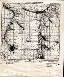
-
- Description:
- 1939
- Subject:
- Topical Subject: Soviet Union, Topical Subject: Maps, and Geographic Subject: Valday
- Publisher:
- Главное управление геодезии и картографии при СНК СССР
- Language:
- Russian
- Date Created:
- 1941
- Identifier:
- VAC9619-002181
- Genre:
- Topographic Maps and Military Maps
- Geographic Location:
- Coordinates: 57.6667, 33, 58, 33.5
- Related URL:
- Catalog URL: https://iucat.iu.edu/catalog/5020129 and Download GeoTIFF: https://drive.google.com/open?id=1sMdJu5ffvYiEo-vdAAiLA3cOunomG5ma
- Abstract:
- Modern area represented: Валдай (Valday), Novgorodskaya oblast, Russia
- Call Number:
- G7000 s100 .S7 sheet O-36-79
- Caption:
- Для служебного пользования
- City:
- Валдай (Valday)
- Copyright Holder:
- No Copyright - United States
- Country:
- СССР (USSR)
- State/Province:
- Калининская область (Kalinin oblast), Ленинградская область (Leningrad oblast), and РСФСР (RSFSR)
- Physical Description:
- Scale: 1:100,000
- Persistent URL:
- http://purl.dlib.indiana.edu/iudl/images/VAC9619/VAC9619-002181
- Provenance:
- DMA Topographic Center, Army Map Service Library, OMAHA, Library of Congress Geography & Map Division
-
- Description:
- 1938
- Subject:
- Topical Subject: Maps, Topical Subject: Soviet Union, and Geographic Subject: Pola
- Publisher:
- Главное управление геодезии и картографии при СНК СССР
- Language:
- Russian
- Date Created:
- 1941
- Identifier:
- VAC9619-002179
- Genre:
- Topographic Maps and Military Maps
- Geographic Location:
- Coordinates: 57.6667, 31.5, 58, 32
- Related URL:
- Download GeoTIFF: https://drive.google.com/open?id=1zZnyMHQgQK-baO9C0ftoFCyAmTtGdxBD and Catalog URL: https://iucat.iu.edu/catalog/5020129
- Abstract:
- Modern area represented: Пола (Pola), Novgorodskaya oblast, Russia
- Call Number:
- G7000 s100 .S7 sheet O-36-76
- Caption:
- Captured map and Для служебного пользования
- City:
- Пола (Pola)
- Copyright Holder:
- No Copyright - United States
- Country:
- СССР (USSR)
- State/Province:
- РСФСР (RSFSR) and Ленинградская область (Leningrad oblast)
- Physical Description:
- Scale: 1:100,000
- Persistent URL:
- http://purl.dlib.indiana.edu/iudl/images/VAC9619/VAC9619-002179
- Provenance:
- DMA Topographic Center, Army Map Service Library, OMAHA, Library of Congress Geography & Map Division
-
- Description:
- 1938
- Subject:
- Topical Subject: Soviet Union, Topical Subject: Maps, and Geographic Subject: Semenovshchina
- Publisher:
- Главное управление геодезии и картографии при СНК СССР
- Language:
- Russian
- Date Created:
- 1941
- Identifier:
- VAC9619-002180
- Genre:
- Topographic Maps and Military Maps
- Geographic Location:
- Coordinates: 57.6667, 32.5, 58, 33
- Related URL:
- Catalog URL: https://iucat.iu.edu/catalog/5020129 and Download GeoTIFF: https://drive.google.com/open?id=1IuWKZFYlg0ERFxDENwk3hpui7Kl6umeq
- Abstract:
- Modern area represented: Семеновщина (Semenovshchina), Novgorodskaya oblast, Russia
- Call Number:
- G7000 s100 .S7 sheet O-36-78
- Caption:
- Для служебного пользования and Captured map
- City:
- Семеновщина (Semenovshchina)
- Copyright Holder:
- No Copyright - United States
- Country:
- СССР (USSR)
- State/Province:
- РСФСР (RSFSR) and Ленинградская область (Leningrad oblast)
- Physical Description:
- Scale: 1:100,000
- Persistent URL:
- http://purl.dlib.indiana.edu/iudl/images/VAC9619/VAC9619-002180
- Provenance:
- DMA Topographic Center, Army Map Service Library, Library of Congress G & M Division
-
- Description:
- 1936
- Subject:
- Topical Subject: Maps, Geographic Subject: Svetlograd, and Topical Subject: Soviet Union
- Publisher:
- Главное управление геодезии и картографии при СНК СССР
- Language:
- Russian
- Date Created:
- 1941
- Identifier:
- VAC9619-002169
- Genre:
- Military Maps and Topographic Maps
- Geographic Location:
- Coordinates: 45, 42.5, 45.33333, 43
- Related URL:
- Catalog URL: https://iucat.iu.edu/catalog/5020129 and Download GeoTIFF: https://drive.google.com/open?id=1uFPKdptgUTl0ZXnLCivKm0m4gwI7N7YD
- Abstract:
- Modern area represented: Svetlograd, Stavropol kray, Russia
- Call Number:
- G7000 s100 .S7 sheet L-38-98
- Caption:
- Для служебного пользования
- City:
- Петровское (Petrovskoye)
- Copyright Holder:
- No Copyright - United States
- Country:
- СССР (USSR)
- State/Province:
- Орджоникидзевский край (Ordzhonikidze kray) and РСФСР (RSFSR)
- Physical Description:
- Scale: 1:100,000
- Persistent URL:
- http://purl.dlib.indiana.edu/iudl/images/VAC9619/VAC9619-002169
- Provenance:
- CIA Map Library
-
- Description:
- 1936
- Subject:
- Geographic Subject: Stavropol’ Kray, Topical Subject: Soviet Union, Topical Subject: Maps, and Geographic Subject: Mikhaylovsk
- Publisher:
- Главное управление геодезии и картографии при СНК СССР
- Language:
- Russian
- Date Created:
- 1941
- Identifier:
- VAC9619-002168
- Genre:
- Topographic Maps and Military Maps
- Geographic Location:
- Coordinates: 45, 42, 45.3333, 42.5
- Related URL:
- Catalog URL: https://iucat.iu.edu/catalog/5020129 and Download GeoTIFF: https://drive.google.com/open?id=1SDUASERAp2Xua0SE6VQ-0tUsk-iwCoOx
- Abstract:
- Modern area represented: Михайловск (Mikhaylovsk), Stavropol' Kray, Russia
- Call Number:
- G7000 s100 .S7 sheet L-38-97
- Caption:
- Для cлужебного пользования
- City:
- Михайловское (Mikhaylovskoe)
- Copyright Holder:
- No Copyright - United States
- Country:
- СССР (USSR)
- State/Province:
- РСФСР (RSFSR) and Орджоникидзевский край (Ordzhonikidze kray)
- Physical Description:
- Scale: 1:100,000
- Persistent URL:
- http://purl.dlib.indiana.edu/iudl/images/VAC9619/VAC9619-002168
- Provenance:
- Geographic Names Branch, Army Map Service Library
-
- Description:
- 1936
- Subject:
- Geographic Subject: Oktyabrskoye, Topical Subject: Maps, and Topical Subject: Soviet Union
- Publisher:
- Главное управление геодезии и картографии при СНК СССР
- Language:
- Russian
- Date Created:
- 1941
- Identifier:
- VAC9619-002160
- Genre:
- Military Maps and Topographic Maps
- Geographic Location:
- Coordinates: 45.3333, 42.5, 45.6667, 43
- Related URL:
- Catalog URL: https://iucat.iu.edu/catalog/5020129 and Download GeoTIFF: https://drive.google.com/open?id=1WkVt36FFEsQFL0DIUFDkyXz9u-WMgFlz
- Abstract:
- Modern area represented: Oktyabrskoye, Stavropol kray, Russia
- Call Number:
- G7000 s100 .S7 sheet L-38-86
- Caption:
- Для служебного пользования
- City:
- Книгинское (Kniginskoye)
- Copyright Holder:
- No Copyright - United States
- Country:
- СССР (USSR)
- State/Province:
- Орджоникидзевский край (Ordzhonikidze kray) and РСФСР (RSFSR)
- Physical Description:
- Scale: 1:100,000
- Persistent URL:
- http://purl.dlib.indiana.edu/iudl/images/VAC9619/VAC9619-002160
- Provenance:
- CIA Map Library
-
- Description:
- 1936
- Subject:
- Geographic Subject: Stavropol’ Kray, Topical Subject: Soviet Union, Geographic Subject: Trunovskoye, and Topical Subject: Maps
- Publisher:
- Главное управление геодезии и картографии при СНК СССР
- Language:
- Russian
- Date Created:
- 1941
- Identifier:
- VAC9619-002159
- Genre:
- Topographic Maps and Military Maps
- Geographic Location:
- Coordinates: 45.3333, 42, 45.6667, 42.5
- Related URL:
- Catalog URL: https://iucat.iu.edu/catalog/5020129 and Download GeoTIFF: https://drive.google.com/file/d/1tb7KRPgwX3gBKo-gLHWMvbXOeFbelWP1/view?usp=sharing
- Abstract:
- Modern area represented: Труновское (Trunovskoye), Stavropol’ Kray, Russia
- Call Number:
- G7000 s100 .S7 sheet L-38-85
- Caption:
- Для cлужебного пользования
- City:
- Труновское (Trunovskoye)
- Copyright Holder:
- No Copyright - United States
- Country:
- СССР (USSR)
- State/Province:
- Орджоникидзевский край (Ordzhonikidze kray) and РСФСР (RSFSR)
- Physical Description:
- Scale: 1:100,000
- Persistent URL:
- http://purl.dlib.indiana.edu/iudl/images/VAC9619/VAC9619-002159
- Provenance:
- DMA Topographic Center, Army Map Service Library, OMAHA
-
- Description:
- 1936
- Subject:
- Geographic Subject: Trunovskoye, Geographic Subject: Stavropol’ Kray, Topical Subject: Soviet Union, and Topical Subject: Maps
- Publisher:
- Главное управление геодезии и картографии при СНК СССР
- Language:
- Russian
- Date Created:
- 1941
- Identifier:
- VAC9619-002158
- Genre:
- Military Maps and Topographic Maps
- Geographic Location:
- Coordinates: 45.3333, 42, 45.6667, 42.5
- Related URL:
- Catalog URL: https://iucat.iu.edu/catalog/5020129 and Download GeoTIFF: https://drive.google.com/open?id=10xtCEHxZI0O_vAA1orjnC4WOAmmiclsv
- Abstract:
- Modern area represented: Труновское (Trunovskoye), Stavropol’ Kray, Russia
- Call Number:
- G7000 s100 .S7 sheet L-38-85
- Caption:
- Для cлужебного пользования
- City:
- Труновское (Trunovskoye)
- Copyright Holder:
- No Copyright - United States
- Country:
- СССР (USSR)
- State/Province:
- Орджоникидзевский край (Ordzhonikidze kray) and РСФСР (RSFSR)
- Physical Description:
- Scale: 1:100,000
- Persistent URL:
- http://purl.dlib.indiana.edu/iudl/images/VAC9619/VAC9619-002158
- Provenance:
- DMA Topographic Center, Army Map Service Library
-
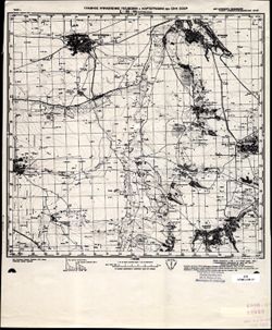
- Description:
- 1939
- Subject:
- Topical Subject: Soviet Union, Geographic Subject: Shuya, and Topical Subject: Maps
- Publisher:
- Главное управление геодезии и картографии при СНК СССР
- Language:
- Russian
- Date Created:
- 1941
- Identifier:
- VAC9619-002151
- Genre:
- Topographic Maps and Military Maps
- Geographic Location:
- Coordinates: 58, 33, 58.3333, 33.5
- Related URL:
- Catalog URL: https://iucat.iu.edu/catalog/5020129 and Download GeoTIFF: https://drive.google.com/open?id=12B3cJ_5IrjQRm_PXq7FKNN4Nd9o_O4NM
- Abstract:
- Modern area represented: Шуя (Shuya), Novgorodskaya oblast, Russia
- Call Number:
- G7000 s100 .S7 sheet O-36-67
- Caption:
- Captured map and Для служебного пользования
- City:
- Шуя (Shuya)
- Copyright Holder:
- No Copyright - United States
- Country:
- СССР (USSR)
- State/Province:
- РСФСР (RSFSR) and Ленинградская область (Leningrad oblast)
- Physical Description:
- Scale: 1:100,000
- Persistent URL:
- http://purl.dlib.indiana.edu/iudl/images/VAC9619/VAC9619-002151
- Provenance:
- DMA Topographic Center, Army Map Service Library, OMAHA, Library of Congress Geography & Map Division
-
- Description:
- 1938
- Subject:
- Topical Subject: Maps, Geographic Subject: Kresttsy, and Topical Subject: Soviet Union
- Publisher:
- Главное управление геодезии и картографии при СНК СССР
- Language:
- Russian
- Date Created:
- 1941
- Identifier:
- VAC9619-002150
- Genre:
- Topographic Maps and Military Maps
- Geographic Location:
- Coordinates: 58, 32.5, 58.3333, 33
- Related URL:
- Download GeoTIFF: https://drive.google.com/open?id=147LZZhyDbb9NfmWMNJ_lGbrc1Fuv3XV5 and Catalog URL: https://iucat.iu.edu/catalog/5020129
- Abstract:
- Modern area represented: Крестцы (Kresttsy), Novgorodskaya oblast, Russia
- Call Number:
- G7000 s100 .S7 sheet O-36-66
- Caption:
- Для служебного пользования
- City:
- Крестцы (Kresttsy)
- Copyright Holder:
- No Copyright - United States
- Country:
- СССР (USSR)
- State/Province:
- Ленинградская область (Leningrad oblast) and РСФСР (RSFSR)
- Physical Description:
- Scale: 1:100,000
- Persistent URL:
- http://purl.dlib.indiana.edu/iudl/images/VAC9619/VAC9619-002150
- Provenance:
- DMA Topographic Center, Army Map Service Library, OMAHA, Library of Congress Geography & Map Division
