
Search Constraints
You searched for:
Campus
IUB
Remove constraint Campus: IUB
Holding Location
B-WELLS
Remove constraint Holding Location: B-WELLS
Pages
0-99 pages
Remove constraint Pages: 0-99 pages
State/Province
Смоленская область (Smolensk oblast)
Remove constraint State/Province: Смоленская область (Smolensk oblast)
« Previous |
1 - 100 of 145
|
Next »
Search Results
-
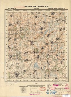
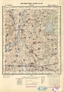
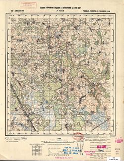
- Description:
- 1939
- Subject:
- Geographic Subject: Lushchikovo, Topical Subject: Soviet Union, and Topical Subject: Maps
- Publisher:
- Главное Управление Геодезии и Картографии при СНК СССР
- Language:
- Russian
- Date Created:
- 1941
- Identifier:
- VAC9619-001316
- Genre:
- Topographic Maps and Military Maps
- Geographic Location:
- Coordinates: 54.667, 33.5, 54.833, 33.75
- Related URL:
- Download GeoTIFF: https://drive.google.com/open?id=1QqwkbeqMxBP_h4g_YQjctsz1Sdi9nkJC and Catalog URL: http://iucat.iu.edu/catalog/5020131
- Abstract:
- Modern area represented: Lushchikovo, Smolensk oblast, Russia
- Call Number:
- GM G7000 S50 .S68 N-36-44-C
- Copyright Holder:
- No Copyright - United States
- Country:
- СССР (USSR)
- State/Province:
- РСФСР (RSFSR) and Смоленская область (Smolensk oblast)
- Physical Description:
- Scale: 1:50,000
- Persistent URL:
- http://purl.dlib.indiana.edu/iudl/images/VAC9619/VAC9619-001316
- Provenance:
- M. I. Map Library, G000-30, CIA Map Library
-
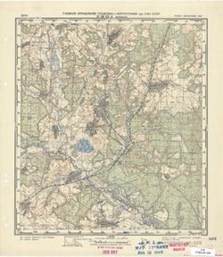
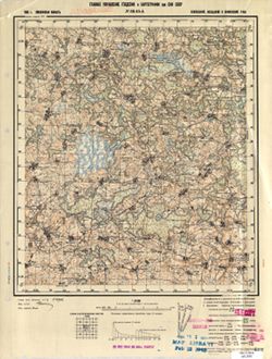
- Description:
- 1939
- Subject:
- Topical Subject: Soviet Union, Topical Subject: Maps, and Geographic Subject: Izdeshkovo
- Publisher:
- Главное Управление Геодезии и Картографии при СНК СССР
- Language:
- Russian
- Date Created:
- 1941
- Identifier:
- VAC9619-001279
- Genre:
- Topographic Maps and Military Maps
- Geographic Location:
- Coordinates: 55, 33.5, 55.1667, 33.75
- Related URL:
- Catalog URL: http://iucat.iu.edu/catalog/5020131 and Download GeoTIFF: https://drive.google.com/open?id=1faYxK24tGSL97hddlLxmt0CZjGIxZEcN
- Abstract:
- Modern area represented: Izdeshkovo, Smolensk oblast, Russia
- Call Number:
- GM G7000 S50 .S68 N-36-32-B
- Copyright Holder:
- No Copyright - United States
- Country:
- СССР (USSR)
- State/Province:
- РСФСР (RSFSR) and Смоленская область (Smolensk oblast)
- Physical Description:
- Scale: 1:50,000
- Persistent URL:
- http://purl.dlib.indiana.edu/iudl/images/VAC9619/VAC9619-001279
- Provenance:
- M. I. Map Library, G000-30, CIA Map Library
-
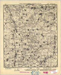
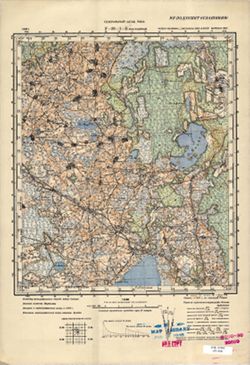
- Description:
- 1939
- Subject:
- Topical Subject: Maps, Topical Subject: Soviet Union, and Geographic Subject: Gagarin
- Publisher:
- Главное Управление Геодезии и Картографии при СНК СССР
- Language:
- Russian
- Identifier:
- VAC9619-001250
- Genre:
- Military Maps and Topographic Maps
- Geographic Location:
- Coordinates: 55.5, 35, 55.667, 35.25
- Related URL:
- Catalog URL: http://iucat.iu.edu/catalog/5020131 and Download GeoTIFF: https://drive.google.com/open?id=14xt8ZsLjrbcMlLXbp_0N2WGRru2MAmmh
- Abstract:
- Modern area represented: Gagarin, Smolensk oblast, Russia
- Call Number:
- GM G7000 S50 .S68 N-36-23-A
- Copyright Holder:
- No Copyright - United States
- Country:
- СССР (USSR)
- State/Province:
- РСФСР (RSFSR) and Смоленская область (Smolensk oblast)
- Physical Description:
- Scale: 1:50,000
- Persistent URL:
- http://purl.dlib.indiana.edu/iudl/images/VAC9619/VAC9619-001250
- Provenance:
- CIA Map Branch -- Received
-
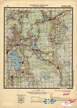
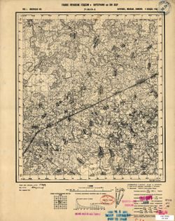
- Description:
- 1939
- Subject:
- Topical Subject: Soviet Union, Topical Subject: Maps, and Geographic Subject: Bolshaya Azarovka
- Publisher:
- Главное Управление Геодезии и Картографии при СНК СССР
- Language:
- Russian
- Identifier:
- VAC9619-001283
- Genre:
- Topographic Maps and Military Maps
- Geographic Location:
- Coordinates: 55.1667, 34.5, 55.3333, 34.75
- Related URL:
- Catalog URL: http://iucat.iu.edu/catalog/5020131 and Download GeoTIFF: https://drive.google.com/open?id=14zIkYmsyFQgk6tEwJ78Cgwaue062mPCU
- Abstract:
- Modern area represented: Bolshaya Azarovka, Smolensk oblast, Russia
- Call Number:
- GM G7000 S50 .S68 N-36-34-A
- Copyright Holder:
- No Copyright - United States
- Country:
- СССР (USSR)
- State/Province:
- РСФСР (RSFSR) and Смоленская область (Smolensk oblast)
- Physical Description:
- Scale: 1:50,000
- Persistent URL:
- http://purl.dlib.indiana.edu/iudl/images/VAC9619/VAC9619-001283
- Provenance:
- CIA Map Branch -- Received
-
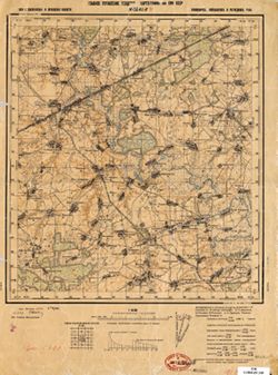
- Description:
- 1939
- Subject:
- Geographic Subject: Karpovo, Topical Subject: Maps, and Topical Subject: Soviet Union
- Publisher:
- Главное Управление Геодезии и Картографии при СНК СССР
- Language:
- Russian
- Identifier:
- VAC9619-001286
- Genre:
- Military Maps and Topographic Maps
- Geographic Location:
- Coordinates: 55, 34.75, 55.1667, 35
- Related URL:
- Catalog URL: http://iucat.iu.edu/catalog/5020131 and Download GeoTIFF: https://drive.google.com/open?id=1XlcQMtIZuRcF57Sk2_h1eNuLbc0cVF3m
- Abstract:
- Modern area represented: Karpovo, Smolensk oblast, Russia
- Call Number:
- GM G7000 S50 .S68 N-36-34-Г
- Copyright Holder:
- No Copyright - United States
- Country:
- СССР (USSR)
- State/Province:
- Смоленская область (Smolensk oblast) and РСФСР (RSFSR)
- Physical Description:
- Scale: 1:50,000
- Persistent URL:
- http://purl.dlib.indiana.edu/iudl/images/VAC9619/VAC9619-001286
- Provenance:
- CIA Map Branch -- Received
-
- Description:
- 1927
- Subject:
- Topical Subject: Maps, Geographic Subject: Igorevskaya, and Topical Subject: Soviet Union
- Publisher:
- Генеральный штаб Красной Армии
- Language:
- Russian
- Date Created:
- 1941
- Identifier:
- VAC9619-004158
- Genre:
- Topographic Maps and Military Maps
- Geographic Location:
- Coordinates: 55.333, 33, 55.667, 33.5
- Related URL:
- Catalog URL: https://iucat.iu.edu/catalog/5020129 and Download GeoTIFF: https://drive.google.com/file/d/1tXZz6qmdU4rjmW8T_8LquCxS1UF9hXqC/view?usp=sharing
- Abstract:
- Modern area represented: Igorevskaya, Smolensk oblast, Russia
- Call Number:
- G7000 s100 .S7 sheet N-36-19
- City:
- Игорьевская (Igorevskaya)
- Copyright Holder:
- No Copyright - United States
- Country:
- СССР (USSR)
- State/Province:
- РСФСР (RSFSR) and Смоленская область (Smolensk oblast)
- Physical Description:
- Scale: 1:100,000
- Persistent URL:
- http://purl.dlib.indiana.edu/iudl/images/VAC9619/VAC9619-004158
-
- Description:
- 1926
- Subject:
- Topical Subject: Soviet Union, Geographic Subject: Usvyata, and Topical Subject: Maps
- Publisher:
- Генеральный штаб РККА
- Language:
- Russian
- Identifier:
- VAC9619-001185
- Genre:
- Military Maps and Topographic Maps
- Geographic Location:
- Coordinates: 55.6667, 30.75, 55.8333, 31
- Related URL:
- Catalog URL: http://iucat.iu.edu/catalog/5020131 and Download GeoTIFF: https://drive.google.com/open?id=1LfDnjyQimu1w-GGzLKdUvdo_k8BYoSs-
- Abstract:
- Modern area represented: Usvyata, Pskov oblast, Russia
- Call Number:
- GM G7000 S50 .S68 Т-36-2-Г
- Caption:
- Не подлежит оглашению
- City:
- Усвяты (Usvyata)
- Copyright Holder:
- No Copyright - United States
- Country:
- СССР (USSR)
- State/Province:
- РСФСР (RSFSR) and Смоленская область (Smolensk oblast)
- Physical Description:
- Scale: 1:50,000
- Persistent URL:
- http://purl.dlib.indiana.edu/iudl/images/VAC9619/VAC9619-001185
- Provenance:
- Library of Congress Geography & Map Division
-
- Description:
- 1924
- Subject:
- Topical Subject: Soviet Union, Geographic Subject: Shamovo, and Topical Subject: Maps
- Publisher:
- Военно-топографическое управление
- Language:
- Russian
- Identifier:
- VAC9619-001370
- Genre:
- Topographic Maps and Military Maps
- Geographic Location:
- Coordinates: 54.167, 31.25, 54.333, 31.5
- Related URL:
- Download GeoTIFF: https://drive.google.com/open?id=115C2WorHArrVdBWJ3bF4PEhN48TSRXE9 and Catalog URL: http://iucat.iu.edu/catalog/5020131
- Abstract:
- Modern area represented: Shamovo, Mogilev oblast, Belarus
- Call Number:
- GM G7000 S50 .S68 N-36-63-Б
- Caption:
- Секретно
- City:
- Шамово (Shamovo)
- Copyright Holder:
- No Copyright - United States
- Country:
- СССР (USSR)
- State/Province:
- Белорусская ССР (Byelorussian Soviet Socialist Republic), РСФСР (RSFSR), and Смоленская область (Smolensk oblast)
- Physical Description:
- Scale: 1:50,000
- Persistent URL:
- http://purl.dlib.indiana.edu/iudl/images/VAC9619/VAC9619-001370
- Provenance:
- CIA Map Branch -- Received, M. I. Map Library
-
- Description:
- 1939
- Subject:
- Topical Subject: Soviet Union, Geographic Subject: Khotozha, and Topical Subject: Maps
- Publisher:
- Главное Управление Геодезии и Картографии при СНК СССР
- Language:
- Russian
- Date Created:
- 1941
- Identifier:
- VAC9619-001389
- Genre:
- Military Maps and Topographic Maps
- Geographic Location:
- Coordinates: 54, 33.75, 54.167, 34
- Related URL:
- Download GeoTIFF: https://drive.google.com/open?id=1YZoZQ-XsDJNfCS8cX8Ph2poMYtr77OBC and Catalog URL: http://iucat.iu.edu/catalog/5020131
- Abstract:
- Modern area represented: Khotozha, Kaluga oblast, Russia
- Call Number:
- GM G7000 S50 .S68 N-36-68-Г
- City:
- Хотожка (Khotozha)
- Copyright Holder:
- No Copyright - United States
- Country:
- СССР (USSR)
- State/Province:
- РСФСР (RSFSR) and Смоленская область (Smolensk oblast)
- Physical Description:
- Scale: 1:50,000
- Persistent URL:
- http://purl.dlib.indiana.edu/iudl/images/VAC9619/VAC9619-001389
- Provenance:
- CIA Map Branch -- Received, Library of Congress Geography & Map Division, FEM Austria
-
- Description:
- 1940
- Subject:
- Topical Subject: Soviet Union, Geographic Subject: Slagovishchi, and Topical Subject: Maps
- Publisher:
- Главное Управление Геодезии и Картографии при СНК СССР
- Language:
- Russian
- Date Created:
- 1941
- Identifier:
- VAC9619-001429
- Genre:
- Topographic Maps and Military Maps
- Geographic Location:
- Coordinates: 53.833, 35.75, 54, 36
- Related URL:
- Catalog URL: http://iucat.iu.edu/catalog/5020131 and Download GeoTIFF: https://drive.google.com/open?id=1oqQ_Jwap6JQmn5gSc_0feHfoVhOgIhSE
- Abstract:
- Modern area represented: Slagovishchi, Kaluga oblast, Russia
- Call Number:
- GM G7000 S50 .S68 N-36-84-B
- City:
- Слаговищи (Slagovishchi)
- Copyright Holder:
- No Copyright - United States
- Country:
- СССР (USSR)
- State/Province:
- РСФСР (RSFSR), Тульская область (Tula oblast), and Смоленская область (Smolensk oblast)
- Physical Description:
- Scale: 1:50,000
- Persistent URL:
- http://purl.dlib.indiana.edu/iudl/images/VAC9619/VAC9619-001429
- Provenance:
- G000-30, Atlasblatt, CIA Map Library, M. I. Map Library
-
- Description:
- 1939
- Subject:
- Topical Subject: Maps, Topical Subject: Soviet Union, and Geographic Subject: Boldino
- Publisher:
- Генеральный штаб Красной Армии
- Language:
- Russian
- Date Created:
- 1941
- Identifier:
- VAC9619-004184
- Genre:
- Military Maps and Topographic Maps
- Geographic Location:
- Coordinates: 54.667, 33.5, 55, 34
- Related URL:
- Catalog URL: https://iucat.iu.edu/catalog/5020129 and Download GeoTIFF: https://drive.google.com/file/d/1LKXt2KGghnQCNC6fOnFJkqXDDzLPm-A0/view?usp=sharing
- Abstract:
- Modern area represented: Boldino, Smolensk oblast, Russia
- Call Number:
- G7000 s100 .S7 sheet N-36-44
- Caption:
- Для служебного пользования
- City:
- Болдино (Boldino)
- Copyright Holder:
- No Copyright - United States
- Country:
- СССР (USSR)
- State/Province:
- Смоленская область (Smolensk oblast) and РСФСР (RSFSR)
- Physical Description:
- Scale: 1:100,000
- Persistent URL:
- http://purl.dlib.indiana.edu/iudl/images/VAC9619/VAC9619-004184
-
- Description:
- 1924
- Subject:
- Topical Subject: Soviet Union, Geographic Subject: Yelnya, and Topical Subject: Maps
- Publisher:
- Генеральный штаб РККА
- Language:
- Russian
- Identifier:
- VAC9619-001345
- Genre:
- Topographic Maps and Military Maps
- Geographic Location:
- Coordinates: 54.5, 33, 54.667, 33.25
- Related URL:
- Catalog URL: http://iucat.iu.edu/catalog/5020131 and Download GeoTIFF: https://drive.google.com/open?id=1Hc3gne0kokapt9JBCCH1kf9twdxBgZda
- Abstract:
- Modern area represented: Yelnya, Smolensk oblast, Russia
- Call Number:
- GM G7000 S50 .S68 N-36-55-A
- Caption:
- Не подлежит оглашению
- City:
- Ельня (Yelnya)
- Copyright Holder:
- No Copyright - United States
- Country:
- СССР (USSR)
- State/Province:
- РСФСР (RSFSR) and Смоленская область (Smolensk oblast)
- Physical Description:
- Scale: 1:50,000
- Persistent URL:
- http://purl.dlib.indiana.edu/iudl/images/VAC9619/VAC9619-001345
- Provenance:
- M. I. Map Library, GS, RA
-
- Description:
- 1939
- Subject:
- Topical Subject: Maps, Geographic Subject: Byvalki, and Topical Subject: Soviet Union
- Publisher:
- Главное Управление Геодезии и Картографии при СНК СССР
- Language:
- Russian
- Date Created:
- 1941
- Identifier:
- VAC9619-001352
- Genre:
- Military Maps and Topographic Maps
- Geographic Location:
- Coordinates: 54.333, 33.5, 54.5, 33.75
- Related URL:
- Catalog URL: http://iucat.iu.edu/catalog/5020131 and Download GeoTIFF: https://drive.google.com/open?id=1kQ8buSy9xAM0hjOROVgxVqhnHpQ2tthm
- Abstract:
- Modern area represented: Byvalki, Smolensk oblast, Russia
- Call Number:
- GM G7000 S50 .S68 N-36-56-B
- Copyright Holder:
- No Copyright - United States
- Country:
- СССР (USSR)
- State/Province:
- РСФСР (RSFSR) and Смоленская область (Smolensk oblast)
- Physical Description:
- Scale: 1:50,000
- Persistent URL:
- http://purl.dlib.indiana.edu/iudl/images/VAC9619/VAC9619-001352
- Provenance:
- M. I. Map Library, Atlasblatt, Library of Congress Geography & Map Division, G000-30
-
- Description:
- 1940
- Subject:
- Geographic Subject: Duminichi, Topical Subject: Maps, and Topical Subject: Soviet Union
- Publisher:
- Главное Управление Геодезии и Картографии при СНК СССР
- Language:
- Russian
- Date Created:
- 1941
- Identifier:
- VAC9619-001425
- Genre:
- Topographic Maps and Military Maps
- Geographic Location:
- Coordinates: 53.833, 35, 54, 35.25
- Related URL:
- Download GeoTIFF: https://drive.google.com/open?id=1-OUGxb5wYSJg2BnxEKvEbl5c4H9EJWzr and Catalog URL: http://iucat.iu.edu/catalog/5020131
- Abstract:
- Modern area represented: Duminichi, Kaluga oblast, Russia
- Call Number:
- GM G7000 S50 .S68 N-36-83-A
- City:
- Думиничи (Duminichi)
- Copyright Holder:
- No Copyright - United States
- Country:
- СССР (USSR)
- State/Province:
- Смоленская область (Smolensk oblast) and РСФСР (RSFSR)
- Physical Description:
- Scale: 1:50,000
- Persistent URL:
- http://purl.dlib.indiana.edu/iudl/images/VAC9619/VAC9619-001425
- Provenance:
- G000-30, CIA Map Library, M. I. Map Library
-
- Description:
- 1939
- Subject:
- Topical Subject: Maps, Topical Subject: Soviet Union, and Geographic Subject: Mishino
- Publisher:
- Главное Управление Геодезии и Картографии при СНК СССР
- Language:
- Russian
- Identifier:
- VAC9619-001251
- Genre:
- Military Maps and Topographic Maps
- Geographic Location:
- Coordinates: 55.333, 35, 55.5, 35.25
- Related URL:
- Download GeoTIFF: https://drive.google.com/open?id=1GSxBTvYsIzTmWlRNUFpvDE2dD0T3PsJP and Catalog URL: http://iucat.iu.edu/catalog/5020131
- Abstract:
- Modern area represented: Mishino, Smolensk oblast, Russia
- Call Number:
- GM G7000 S50 .S68 N-36-23-B
- City:
- Мишино (Mishino)
- Copyright Holder:
- No Copyright - United States
- Country:
- СССР (USSR)
- State/Province:
- РСФСР (RSFSR) and Смоленская область (Smolensk oblast)
- Physical Description:
- Scale: 1:50,000
- Persistent URL:
- http://purl.dlib.indiana.edu/iudl/images/VAC9619/VAC9619-001251
- Provenance:
- M. I. Map Library, G000-30, Atlasblatt
-
- Description:
- 1926
- Subject:
- Topical Subject: Maps, Geographic Subject: Usvyata, and Topical Subject: Soviet Union
- Publisher:
- Генеральный штаб Красной Армии
- Language:
- Russian
- Identifier:
- VAC9619-001186
- Genre:
- Military Maps and Topographic Maps
- Geographic Location:
- Coordinates: 55.6667, 30.75, 55.8333, 31
- Related URL:
- Catalog URL: http://iucat.iu.edu/catalog/5020131 and Download GeoTIFF: https://drive.google.com/file/d/14TWghq7AEVCcozr9IZCGRwK0n2CPP7m1/view?usp=sharing
- Abstract:
- Modern area represented: Usvyata, Pskov oblast, Russia
- Call Number:
- GM G7000 S50 .S68 N-36-2-Г
- Caption:
- Для служебного пользования
- City:
- Усвяты (Usvyata)
- Copyright Holder:
- No Copyright - United States
- Country:
- СССР (USSR)
- State/Province:
- Смоленская область (Smolensk oblast) and РСФСР (RSFSR)
- Physical Description:
- Scale: 1:50,000
- Persistent URL:
- http://purl.dlib.indiana.edu/iudl/images/VAC9619/VAC9619-001186
- Provenance:
- M. I. Map Library, G000-30, GS, RA, Atlasblatt
-
- Description:
- 1939
- Subject:
- Topical Subject: Soviet Union and Topical Subject: Maps
- Publisher:
- Главное Управление Геодезии и Картографии при СНК СССР
- Language:
- Russian
- Date Created:
- 1941
- Identifier:
- VAC9619-001277
- Genre:
- Topographic Maps and Military Maps
- Geographic Location:
- Coordinates: 55.1667, 33.5, 55.3333, 33.75
- Related URL:
- Download GeoTIFF: https://drive.google.com/open?id=1rpQE7knj3hOj8hr9lhM7dz7vcitFzIdF and Catalog URL: http://iucat.iu.edu/catalog/5020131
- Abstract:
- Modern area represented: Smolensk oblast, Russia
- Call Number:
- GM G7000 S50 .S68 N-36-32-A
- Copyright Holder:
- No Copyright - United States
- Country:
- СССР (USSR)
- State/Province:
- Смоленская область (Smolensk oblast) and РСФСР (RSFSR)
- Physical Description:
- Scale: 1:50,000
- Persistent URL:
- http://purl.dlib.indiana.edu/iudl/images/VAC9619/VAC9619-001277
- Provenance:
- M. I. Map Library, G000-30
-
- Description:
- 1937
- Subject:
- Topical Subject: Maps, Geographic Subject: Bolshaya Budnitsa, and Topical Subject: Soviet Union
- Publisher:
- Генеральный штаб РККА
- Language:
- Russian
- Identifier:
- VAC9619-001181
- Genre:
- Topographic Maps and Military Maps
- Geographic Location:
- Coordinates: 55.8333, 30.25, 56, 30.5
- Related URL:
- Download GeoTIFF: https://drive.google.com/open?id=1cloBA9T45spXH6I5DTUJSE1CtybxFlWa and Catalog URL: http://iucat.iu.edu/catalog/5020131
- Abstract:
- Modern area represented: Bolshaya Budnitsa, Pskov oblast, Russia
- Call Number:
- GM G7000 S50 .S68 N-36-1-Б
- Caption:
- Не подлежит оглашению
- City:
- Бол. Будница (Bolshaya Budnitsa)
- Copyright Holder:
- No Copyright - United States
- Country:
- СССР (USSR)
- State/Province:
- Калининская область (Kalinin oblast), Смоленская область (Smolensk oblast), Витебская область (Vitebsk oblast), РСФСР (RSFSR), and Белорусская ССР (Byeloruss...
- Physical Description:
- Scale: 1:50,000
- Persistent URL:
- http://purl.dlib.indiana.edu/iudl/images/VAC9619/VAC9619-001181
- Provenance:
- M. I. Map Library, G000-30
-
- Description:
- 1939
- Subject:
- Topical Subject: Maps, Topical Subject: Soviet Union, and Geographic Subject: Klyuchi
- Publisher:
- Главное Управление Геодезии и Картографии при СНК СССР
- Language:
- Russian
- Identifier:
- VAC9619-001355
- Genre:
- Military Maps and Topographic Maps
- Geographic Location:
- Coordinates: 54.5, 34.5, 54.667, 34.75
- Related URL:
- Download GeoTIFF: https://drive.google.com/open?id=1nyWQMztC_MtJNUp2e5--FKTCQj6mXaBW and Catalog URL: http://iucat.iu.edu/catalog/5020131
- Abstract:
- Modern area represented: Klyuchi, Kaluga oblast, Russia
- Call Number:
- GM G7000 S50 .S68 N-36-58-A
- Copyright Holder:
- No Copyright - United States
- Country:
- СССР (USSR)
- State/Province:
- Смоленская область (Smolensk oblast) and РСФСР (RSFSR)
- Physical Description:
- Scale: 1:50,000
- Persistent URL:
- http://purl.dlib.indiana.edu/iudl/images/VAC9619/VAC9619-001355
- Provenance:
- M. I. Map Library, Atlasblatt, Library of Congress Geography & Map Division, G000-30
-
- Description:
- 1939
- Subject:
- Topical Subject: Maps, Geographic Subject: Klyuksovo, and Topical Subject: Soviet Union
- Publisher:
- Главное Управление Геодезии и Картографии при СНК СССР
- Language:
- Russian
- Date Created:
- 1941
- Identifier:
- VAC9619-001388
- Genre:
- Military Maps and Topographic Maps
- Geographic Location:
- Coordinates: 54, 33.25, 54.167, 33.25
- Related URL:
- Download GeoTIFF: https://drive.google.com/open?id=1K-CTkjyzd1iNouunfqfw6XFYHs4lY5o8 and Catalog URL: http://iucat.iu.edu/catalog/5020131
- Abstract:
- Modern area represented: Klyuksovo, Smolensk oblast, Russia
- Call Number:
- GM G7000 S50 .S68 N-36-67-Г
- Copyright Holder:
- No Copyright - United States
- Country:
- СССР (USSR)
- State/Province:
- Орловская область (Oryol oblast), РСФСР (RSFSR), and Смоленская область (Smolensk oblast)
- Physical Description:
- Scale: 1:50,000
- Persistent URL:
- http://purl.dlib.indiana.edu/iudl/images/VAC9619/VAC9619-001388
- Provenance:
- Library of Congress Geography & Map Division
-
- Description:
- 1924
- Subject:
- Topical Subject: Soviet Union, Geographic Subject: Vederniki, and Topical Subject: Maps
- Publisher:
- Генеральный штаб Красной Армии
- Language:
- Russian
- Identifier:
- VAC9619-001387
- Genre:
- Military Maps and Topographic Maps
- Geographic Location:
- Coordinates: 54.167, 33.25, 54.333, 33.5
- Related URL:
- Download GeoTIFF: https://drive.google.com/open?id=1L55BGJb_yPuVGc6ltY5kP7yi6c9Fs5fa and Catalog URL: http://iucat.iu.edu/catalog/5020131
- Abstract:
- Modern area represented: Vederniki, Smolensk oblast, Russia
- Call Number:
- GM G7000 S50 .S68 N-36-67-Б
- Copyright Holder:
- No Copyright - United States
- Country:
- СССР (USSR)
- State/Province:
- РСФСР (RSFSR), Калужская область (Kaluga oblast), and Смоленская область (Smolensk oblast)
- Physical Description:
- Scale: 1:50,000
- Persistent URL:
- http://purl.dlib.indiana.edu/iudl/images/VAC9619/VAC9619-001387
- Provenance:
- M. I. Map Library, Atlasblatt, Library of Congress Geography & Map Division
-
- Description:
- 1939
- Subject:
- Geographic Subject: Obolovka, Topical Subject: Soviet Union, and Topical Subject: Maps
- Publisher:
- Главное Управление Геодезии и Картографии при СНК СССР
- Language:
- Russian
- Date Created:
- 1941
- Identifier:
- VAC9619-001390
- Genre:
- Military Maps and Topographic Maps
- Geographic Location:
- Coordinates: 54.167, 34, 54.333, 34.25
- Related URL:
- Catalog URL: http://iucat.iu.edu/catalog/5020131 and Download GeoTIFF: https://drive.google.com/open?id=1VsZbplGMsLLd__zWU7u-PLSDg0zyyJ9Q
- Abstract:
- Modern area represented: Obolovka, Kaluga oblast, Russia
- Call Number:
- GM G7000 S50 .S68 N-36-69-A
- Copyright Holder:
- No Copyright - United States
- Country:
- СССР (USSR)
- State/Province:
- Смоленская область (Smolensk oblast) and РСФСР (RSFSR)
- Physical Description:
- Scale: 1:50,000
- Persistent URL:
- http://purl.dlib.indiana.edu/iudl/images/VAC9619/VAC9619-001390
- Provenance:
- M. I. Map Library
-
- Description:
- 1939
- Subject:
- Topical Subject: Soviet Union, Topical Subject: Maps, and Geographic Subject: Kurakino
- Publisher:
- Главное Управление Геодезии и Картографии при СНК СССР
- Language:
- Russian
- Date Created:
- 1941
- Identifier:
- VAC9619-001278
- Genre:
- Topographic Maps and Military Maps
- Geographic Location:
- Coordinates: 55.1667, 33.75, 55.3333, 34
- Related URL:
- Download GeoTIFF: https://drive.google.com/open?id=1AKsGC4KbHS3357tfiJ0Y3yh_KpyZmGy7 and Catalog URL: http://iucat.iu.edu/catalog/5020131
- Abstract:
- Modern area represented: Kurakino, Smolensk oblast, Russia
- Call Number:
- GM G7000 S50 .S68 N-36-32-Б
- Copyright Holder:
- No Copyright - United States
- Country:
- СССР (USSR)
- State/Province:
- Смоленская область (Smolensk oblast) and РСФСР (RSFSR)
- Physical Description:
- Scale: 1:50,000
- Persistent URL:
- http://purl.dlib.indiana.edu/iudl/images/VAC9619/VAC9619-001278
- Provenance:
- M. I. Map Library, G000-30, CIA Map Library
-
- Description:
- 1939
- Subject:
- Geographic Subject: Pavlinovo, Topical Subject: Maps, and Topical Subject: Soviet Union
- Publisher:
- Главное Управление Геодезии и Картографии при СНК СССР
- Language:
- Russian
- Date Created:
- 1941
- Identifier:
- VAC9619-001353
- Genre:
- Military Maps and Topographic Maps
- Geographic Location:
- Coordinates: 54.333, 33.75, 54.5, 34
- Related URL:
- Download GeoTIFF: https://drive.google.com/open?id=1zemijf90ks4fmRp_zIJ2j4HbqoxY341M and Catalog URL: http://iucat.iu.edu/catalog/5020131
- Abstract:
- Modern area represented: Pavlinovo, Kaluga oblast, Russia
- Call Number:
- GM G7000 S50 .S68 N-36-56-Г
- Copyright Holder:
- No Copyright - United States
- Country:
- СССР (USSR)
- State/Province:
- РСФСР (RSFSR) and Смоленская область (Smolensk oblast)
- Physical Description:
- Scale: 1:50,000
- Persistent URL:
- http://purl.dlib.indiana.edu/iudl/images/VAC9619/VAC9619-001353
- Provenance:
- M. I. Map Library, Atlasblatt, Library of Congress Geography & Map Division, G000-30
-
- Description:
- 1939
- Subject:
- Topical Subject: Soviet Union, Topical Subject: Maps, and Geographic Subject: Zimnitsy
- Publisher:
- Главное Управление Геодезии и Картографии при СНК СССР
- Language:
- Russian
- Date Created:
- 1941
- Identifier:
- VAC9619-001354
- Genre:
- Military Maps and Topographic Maps
- Geographic Location:
- Coordinates: 54.333, 34.25, 54.5, 34.5
- Related URL:
- Download GeoTIFF: https://drive.google.com/open?id=1mgLe2nLeiKbHU-4H6JwdJVA5yFmBQWdX and Catalog URL: http://iucat.iu.edu/catalog/5020131
- Abstract:
- Modern area represented: Zimnitsy, Kaluga oblast, Russia
- Call Number:
- GM G7000 S50 .S68 N-36-57-Г
- Copyright Holder:
- No Copyright - United States
- Country:
- СССР (USSR)
- State/Province:
- РСФСР (RSFSR) and Смоленская область (Smolensk oblast)
- Physical Description:
- Scale: 1:50,000
- Persistent URL:
- http://purl.dlib.indiana.edu/iudl/images/VAC9619/VAC9619-001354
- Provenance:
- M. I. Map Library, Atlasblatt, Library of Congress Geography & Map Division, G000-30
-
- Description:
- 1939
- Subject:
- Topical Subject: Soviet Union, Topical Subject: Maps, and Geographic Subject: Ramino
- Publisher:
- Главное Управление Геодезии и Картографии при СНК СССР
- Language:
- Russian
- Identifier:
- VAC9619-001356
- Genre:
- Topographic Maps and Military Maps
- Geographic Location:
- Coordinates: 54.5, 34.75, 54.667, 35
- Related URL:
- Catalog URL: http://iucat.iu.edu/catalog/5020131 and Download GeoTIFF: https://drive.google.com/open?id=1_Iok-Els_YYYrAOCmb52Lid9-QFrwLx1
- Abstract:
- Modern area represented: Ramino, Kaluga oblast, Russia
- Call Number:
- GM G7000 S50 .S68 N-36-58-Б
- Copyright Holder:
- No Copyright - United States
- Country:
- СССР (USSR)
- State/Province:
- РСФСР (RSFSR) and Смоленская область (Smolensk oblast)
- Physical Description:
- Scale: 1:50,000
- Persistent URL:
- http://purl.dlib.indiana.edu/iudl/images/VAC9619/VAC9619-001356
- Provenance:
- M. I. Map Library, Atlasblatt, Library of Congress Geography & Map Division, G000-30
-
- Description:
- 1940
- Subject:
- Topical Subject: Soviet Union, Geographic Subject: Khotkovo, and Topical Subject: Maps
- Publisher:
- Главное Управление Геодезии и Картографии при СНК СССР
- Language:
- Russian
- Date Created:
- 1941
- Identifier:
- VAC9619-001427
- Genre:
- Military Maps and Topographic Maps
- Geographic Location:
- Coordinates: 53.667, 35, 53.833, 35.25
- Related URL:
- Catalog URL: http://iucat.iu.edu/catalog/5020131 and Download GeoTIFF: https://drive.google.com/open?id=18QTLCAcYe0vn4KzBJYmJBTAc_oV42cOi
- Abstract:
- Modern area represented: Khotkovo, Kaluga oblast, Russia
- Call Number:
- GM G7000 S50 .S68 N-36-83-C
- Caption:
- Для служебного пользования
- City:
- Хатьково (Khotkovo)
- Copyright Holder:
- No Copyright - United States
- Country:
- СССР (USSR)
- State/Province:
- Смоленская область (Smolensk oblast), Орловская область (Oryol oblast), and РСФСР (RSFSR)
- Physical Description:
- Scale: 1:50,000
- Persistent URL:
- http://purl.dlib.indiana.edu/iudl/images/VAC9619/VAC9619-001427
- Provenance:
- G000-30, Atlasblatt, CIA Map Library, M. I. Map Library
-
- Description:
- 1924
- Subject:
- Topical Subject: Maps, Geographic Subject: Mstsislaw, and Topical Subject: Soviet Union
- Publisher:
- Военно-топографическое управление
- Language:
- Russian
- Identifier:
- VAC9619-001376
- Genre:
- Military Maps and Topographic Maps
- Geographic Location:
- Coordinates: 54, 31.5, 54.1667, 31.75
- Related URL:
- Catalog URL: http://iucat.iu.edu/catalog/5020131 and Download GeoTIFF: https://drive.google.com/file/d/1YNNrtmv7rSKmpUF9glMZZITRcHm2LvKk/view?usp=sharing
- Abstract:
- Modern area represented: Mstsislaw, Mogilev oblast, Belarus
- Call Number:
- GM G7000 S50 .S68 N-36-64-B2
- Caption:
- Секретно
- City:
- Мстиславль (Mstsislaw)
- Copyright Holder:
- No Copyright - United States
- Country:
- СССР (USSR)
- State/Province:
- Белорусская ССР (Byelorussian Soviet Socialist Republic), Смоленская область (Smolensk oblast), and РСФСР (RSFSR)
- Physical Description:
- Scale: 1:50,000
- Persistent URL:
- http://purl.dlib.indiana.edu/iudl/images/VAC9619/VAC9619-001376
- Provenance:
- M. I. Map Library, Atlasblatt, Library of Congress Geography & Map Division
-
- Description:
- 1939
- Subject:
- Topical Subject: Soviet Union, Topical Subject: Maps, and Geographic Subject: Dorotovka
- Publisher:
- Главное Управление Геодезии и Картографии при СНК СССР
- Language:
- Russian
- Date Created:
- 1941
- Identifier:
- VAC9619-001385
- Genre:
- Military Maps and Topographic Maps
- Geographic Location:
- Coordinates: 54, 32.75, 54.167, 33
- Related URL:
- Download GeoTIFF: https://drive.google.com/open?id=1IFmu6z5cvjyWDNEvhyLru0Dh3wjv-JEo and Catalog URL: http://iucat.iu.edu/catalog/5020131
- Abstract:
- Modern area represented: Dorotovka, Smolensk oblast, Russia
- Call Number:
- GM G7000 S50 .S68 N-36-66-Г
- Copyright Holder:
- No Copyright - United States
- Country:
- СССР (USSR)
- State/Province:
- Смоленская область (Smolensk oblast) and РСФСР (RSFSR)
- Physical Description:
- Scale: 1:50,000
- Persistent URL:
- http://purl.dlib.indiana.edu/iudl/images/VAC9619/VAC9619-001385
- Provenance:
- M. I. Map Library, Atlasblatt, Library of Congress Geography & Map Division, Heeresplankammer Gruppe Archive Auslandskartenarchiv
-
- Description:
- 1939
- Subject:
- Geographic Subject: Putkovo, Topical Subject: Maps, and Topical Subject: Soviet Union
- Publisher:
- Главное Управление Геодезии и Картографии при СНК СССР
- Language:
- Russian
- Date Created:
- 1941
- Identifier:
- VAC9619-001317
- Genre:
- Military Maps and Topographic Maps
- Geographic Location:
- Coordinates: 54.833, 34, 55, 34.25
- Related URL:
- Catalog URL: http://iucat.iu.edu/catalog/5020131 and Download GeoTIFF: https://drive.google.com/open?id=1BHXRUtQQcyv-rlwvf64GS6IM9NcIyy7B
- Abstract:
- Modern area represented: Putkovo, Smolensk oblast, Russia
- Call Number:
- GM G7000 S50 .S68 N-36-45-A
- Copyright Holder:
- No Copyright - United States
- Country:
- СССР (USSR)
- State/Province:
- Смоленская область (Smolensk oblast) and РСФСР (RSFSR)
- Physical Description:
- Scale: 1:50,000
- Persistent URL:
- http://purl.dlib.indiana.edu/iudl/images/VAC9619/VAC9619-001317
- Provenance:
- M. I. Map Library, G000-30, Atlasblatt
-

- Description:
- 1939
- Subject:
- Topical Subject: Maps, Geographic Subject: Yukhnov, and Topical Subject: Soviet Union
- Publisher:
- Генеральный штаб Красной Армии
- Language:
- Russian
- Date Created:
- 1941
- Identifier:
- VAC9619-004187
- Genre:
- Topographic Maps and Military Maps
- Geographic Location:
- Coordinates: 54.667, 35, 55, 35.5
- Related URL:
- Download GeoTIFF: https://drive.google.com/file/d/1cQNBivSSzsjyVCwoyr6v2BrCZDWttVf4/view?usp=sharing and Catalog URL: https://iucat.iu.edu/catalog/5020129
- Abstract:
- Modern area represented: Yukhnov, Kaluga oblast, Russia
- Call Number:
- G7000 s100 .S7 sheet N-36-47
- City:
- Юхнов (Yukhnov)
- Copyright Holder:
- No Copyright - United States
- Country:
- СССР (USSR)
- State/Province:
- Смоленская область (Smolensk oblast) and РСФСР (RSFSR)
- Physical Description:
- Scale: 1:100,000
- Persistent URL:
- http://purl.dlib.indiana.edu/iudl/images/VAC9619/VAC9619-004187
- Provenance:
- DMA Topographic Center, Army Map Service Library, OMAHA
-
- Description:
- 1924
- Subject:
- Topical Subject: Maps, Geographic Subject: Makeyevskaya, and Topical Subject: Soviet Union
- Publisher:
- Генеральный штаб РККА
- Language:
- Russian
- Identifier:
- VAC9619-001307
- Genre:
- Topographic Maps and Military Maps
- Geographic Location:
- Coordinates: 54.833, 32.5, 55, 32.75
- Related URL:
- Download GeoTIFF: https://drive.google.com/open?id=1DEFCkvmGHh4AH9ZIP62l6ti-aIoTcev5 and Catalog URL: http://iucat.iu.edu/catalog/5020131
- Abstract:
- Modern area represented: Makeyevskaya, Smolensk oblast, Russia
- Call Number:
- GM G7000 S50 .S68 N-36-42-A
- Caption:
- Не подлежит оглашению,Рассекречено
- City:
- Макеево (Makeyevo)
- Copyright Holder:
- No Copyright - United States
- Country:
- СССР (USSR)
- State/Province:
- Смоленская область (Smolensk oblast) and РСФСР (RSFSR)
- Physical Description:
- Scale: 1:50,000
- Persistent URL:
- http://purl.dlib.indiana.edu/iudl/images/VAC9619/VAC9619-001307
- Provenance:
- DMA Topographic Center, Army Map Service Library, OMAHA, Library of Congress Geography & Map Division
-
- Description:
- 1938
- Subject:
- Topical Subject: Maps, Geographic Subject: Vasilyevo, and Topical Subject: Soviet Union
- Publisher:
- Главное Управление Геодезии и Картографии при СНК СССР
- Language:
- Russian
- Date Created:
- 1941
- Identifier:
- VAC9619-001873
- Genre:
- Military Maps and Topographic Maps
- Geographic Location:
- Coordinates: 55.1667, 36, 55.3333, 36.25
- Related URL:
- Download GeoTIFF: https://drive.google.com/open?id=1K6w6CW9dTrPwudpPrBYVpbWjdNeeC133 and Catalog URL: http://iucat.iu.edu/catalog/5020131
- Abstract:
- Modern area represented: Vasilyevo, Russia
- Call Number:
- G7000 s50 .S68 sheet N-37-25-A
- City:
- Васильево (Vasilyevo)
- Copyright Holder:
- No Copyright - United States
- Country:
- СССР (USSR)
- State/Province:
- Московская область (Moscow oblast), РСФСР (RSFSR), and Смоленская область (Smolensk oblast)
- Physical Description:
- Scale: 1:50,000
- Persistent URL:
- http://purl.dlib.indiana.edu/iudl/images/VAC9619/VAC9619-001873
- Provenance:
- DMA Topographic Center, Army Map Service Library, OMAHA, Library of Congress Geography & Map Division
-
- Description:
- 1926
- Subject:
- Topical Subject: Soviet Union, Geographic Subject: Safonovo, and Topical Subject: Maps
- Publisher:
- Генеральный штаб Красной Армии
- Language:
- Russian
- Date Created:
- 1941
- Identifier:
- VAC9619-004170
- Genre:
- Military Maps and Topographic Maps
- Geographic Location:
- Coordinates: 55, 33, 55.333, 33.5
- Related URL:
- Catalog URL: https://iucat.iu.edu/catalog/5020129 and Download GeoTIFF: https://drive.google.com/file/d/1TQfijwWKEjycZNIlL3HYUfQEjrbzAlyp/view?usp=sharing
- Abstract:
- Modern area represented: Safonovo, Smolensk oblast, Russia
- Call Number:
- G7000 s100 .S7 sheet N-36-31
- City:
- Сафоново (Safonovo)
- Copyright Holder:
- No Copyright - United States
- Country:
- СССР (USSR)
- State/Province:
- Смоленская область (Smolensk oblast) and РСФСР (RSFSR)
- Physical Description:
- Scale: 1:100,000
- Persistent URL:
- http://purl.dlib.indiana.edu/iudl/images/VAC9619/VAC9619-004170
- Provenance:
- DMA Topographic Center, Library of Congress Geography & Map Division, OMAHA
-

- Description:
- 1939
- Subject:
- Topical Subject: Soviet Union, Geographic Subject: Karmanovo, and Topical Subject: Maps
- Publisher:
- Генеральный штаб Красной Армии
- Language:
- Russian
- Date Created:
- 1941
- Identifier:
- VAC9619-004150
- Genre:
- Topographic Maps and Military Maps
- Geographic Location:
- Coordinates: 55.667, 34.5, 56, 35
- Related URL:
- Download GeoTIFF: https://drive.google.com/file/d/1gODnEnCNkJ7LsHO8wwP5guFmkhqszNsR/view?usp=sharing and Catalog URL: https://iucat.iu.edu/catalog/5020129
- Abstract:
- Modern area represented: Karmanovo, Russia
- Call Number:
- G7000 s100 .S7 sheet N-36-10
- City:
- Карманово (Karmanovo)
- Copyright Holder:
- No Copyright - United States
- Country:
- СССР (USSR)
- State/Province:
- РСФСР (RSFSR), Калининская область (Kalinin oblast), and Смоленская область (Smolensk oblast)
- Physical Description:
- Scale: 1:100,000
- Persistent URL:
- http://purl.dlib.indiana.edu/iudl/images/VAC9619/VAC9619-004150
- Provenance:
- DMA Topographic Center, Army Map Service Library, OMAHA
-
- Description:
- 1939
- Subject:
- Geographic Subject: Sukhinichi, Topical Subject: Maps, and Topical Subject: Soviet Union
- Publisher:
- Генеральный штаб Красной Армии
- Language:
- Russian
- Date Created:
- 1941
- Identifier:
- VAC9619-001899
- Genre:
- Topographic Maps and Military Maps
- Geographic Location:
- Coordinates: 54, 35, 54.3333, 35.5
- Related URL:
- Catalog URL: https://iucat.iu.edu/catalog/5020129 and Download GeoTIFF: https://drive.google.com/open?id=1XGjkZ3m9w5I6YreHuiesrh-XU2TxBbbT
- Abstract:
- Modern area represented: Сухиничи (Sukhinichi), Kaluzhskaya oblast, Russia
- Call Number:
- G7000 s100 .S7 sheet N-36-71
- City:
- Сухиничи (Sukhinichi)
- Copyright Holder:
- No Copyright - United States
- Country:
- СССР (USSR)
- State/Province:
- РСФСР (RSFSR) and Смоленская область (Smolensk oblast)
- Physical Description:
- Scale: 1:100,000
- Persistent URL:
- http://purl.dlib.indiana.edu/iudl/images/VAC9619/VAC9619-001899
- Provenance:
- DMA Topographic Center, Army Map Service Library, OMAHA, Library of Congress Geography & Map Division, Auswärtiges Amt. Geographischer Dienst
-
- Description:
- 1939
- Subject:
- Geographic Subject: Boldino, Topical Subject: Soviet Union, and Topical Subject: Maps
- Publisher:
- Генеральный штаб Красной Армии
- Language:
- Russian
- Date Created:
- 1941
- Identifier:
- VAC9619-004183
- Genre:
- Military Maps and Topographic Maps
- Geographic Location:
- Coordinates: 54.667, 33.5, 55, 34
- Related URL:
- Download GeoTIFF: https://drive.google.com/file/d/1ZdOE8E-RdZYHTBsQ0CUY54GuqYB5ylfV/view?usp=sharing and Catalog URL: https://iucat.iu.edu/catalog/5020129
- Abstract:
- Modern area represented: Boldino, Smolensk oblast, Russia
- Call Number:
- G7000 s100 .S7 sheet N-36-44
- City:
- Болдино (Boldino)
- Copyright Holder:
- No Copyright - United States
- Country:
- СССР (USSR)
- State/Province:
- Смоленская область (Smolensk oblast) and РСФСР (RSFSR)
- Physical Description:
- Scale: 1:100,000
- Persistent URL:
- http://purl.dlib.indiana.edu/iudl/images/VAC9619/VAC9619-004183
- Provenance:
- DMA Topographic Center, Library of Congress G & M Division, OMAHA, Army Map Service Library
-
- Description:
- 1938
- Subject:
- Topical Subject: Maps, Topical Subject: Soviet Union, and Geographic Subject: Rydelovo
- Publisher:
- Главное Управление Геодезии и Картографии при СНК СССР
- Language:
- Russian
- Date Created:
- 1941
- Identifier:
- VAC9619-001205
- Genre:
- Military Maps and Topographic Maps
- Geographic Location:
- Coordinates: 55.8333, 33.25, 56, 33.5
- Related URL:
- Download GeoTIFF: https://drive.google.com/open?id=1QB4vYv8ua3rj35GjIUhueXlyBl0DdP-y and Catalog URL: http://iucat.iu.edu/catalog/5020131
- Abstract:
- Modern area represented: Rydelovo, Tver oblast, Russia
- Call Number:
- GM G7000 S50 .S68 N-36-7-Б
- Copyright Holder:
- No Copyright - United States
- Country:
- СССР (USSR)
- State/Province:
- РСФСР (RSFSR), Калининская область (Kalinin oblast), and Смоленская область (Smolensk oblast)
- Physical Description:
- Scale: 1:50,000
- Persistent URL:
- http://purl.dlib.indiana.edu/iudl/images/VAC9619/VAC9619-001205
- Provenance:
- DMA Topographic Center, Army Map Service Library, Library of Congress Geography & Map Division
-
- Description:
- 1927
- Subject:
- Topical Subject: Maps, Topical Subject: Soviet Union, and Geographic Subject: Zapadnaya Dvina
- Publisher:
- Генеральный штаб Красной Армии
- Language:
- Russian
- Date Created:
- 1941
- Identifier:
- VAC9619-002233
- Genre:
- Military Maps and Topographic Maps
- Geographic Location:
- Coordinates: 56, 32, 56.3333, 32.5
- Related URL:
- Catalog URL: https://iucat.iu.edu/catalog/5020129 and Download GeoTIFF: https://drive.google.com/file/d/1ilppakufLs2qQPDjQwcVhMDRRILKyH-b/view?usp=sharing
- Abstract:
- Modern area represented: Западная Двина (Zapadnaya Dvina), Tverskaya oblast, Russia
- Call Number:
- G7000 s100 .S7 sheet O-36-137
- Caption:
- Captured map
- City:
- Западная Двина (Zapadnaya Dvina)
- Copyright Holder:
- No Copyright - United States
- Country:
- СССР (USSR)
- State/Province:
- Калининская область (Kalinin oblast), Смоленская область (Smolensk oblast), and РСФСР (RSFSR)
- Physical Description:
- Scale: 1:100,000
- Persistent URL:
- http://purl.dlib.indiana.edu/iudl/images/VAC9619/VAC9619-002233
- Provenance:
- DMA Topographic Center, Army Map Service Library
-
- Description:
- 1923
- Subject:
- Topical Subject: Maps, Geographic Subject: Mikulino, and Topical Subject: Soviet Union
- Publisher:
- Генеральный штаб Красной Армии
- Language:
- Russian
- Date Created:
- 1929
- Identifier:
- VAC9619-004166
- Genre:
- Topographic Maps and Military Maps
- Geographic Location:
- Coordinates: 55, 31, 55.333, 31.5
- Related URL:
- Download GeoTIFF: https://drive.google.com/file/d/1AsN_7PHMgiqIo27Jr2t1YGsQSAA7zHEl/view?usp=sharing and Catalog URL: https://iucat.iu.edu/catalog/5020129
- Abstract:
- Modern area represented: Mikulino, Vitebsk oblast, Belarus
- Call Number:
- G7000 s100 .S7 sheet N-36-27
- Caption:
- Для служебного пользования
- City:
- Микулино (Mikulino)
- Copyright Holder:
- No Copyright - United States
- Country:
- СССР (USSR)
- State/Province:
- Белорусская ССР (Byelorussian Soviet Socialist Republic), РСФСР (RSFSR), Смоленская область (Smolensk oblast), and Витебская область (Vitebsk oblast)
- Physical Description:
- Scale: 1:100,000
- Persistent URL:
- http://purl.dlib.indiana.edu/iudl/images/VAC9619/VAC9619-004166
- Provenance:
- DMA Topographic Center, Army Map Service Library, OMAHA
-
- Description:
- 1921
- Subject:
- Geographic Subject: Lyubavichi, Topical Subject: Maps, and Topical Subject: Soviet Union
- Publisher:
- Управление военных топографов РККА
- Language:
- Russian
- Date Created:
- 1923
- Identifier:
- VAC9619-001296
- Genre:
- Military Maps and Topographic Maps
- Geographic Location:
- Coordinates: 54.667, 30.75, 54.833, 31
- Related URL:
- Catalog URL: http://iucat.iu.edu/catalog/5020131 and Download GeoTIFF: https://drive.google.com/open?id=1DUHZ-obrLs5hnBBEXBYjk2YGnXAUpK4z
- Abstract:
- Modern area represented: Lyubavichi, Smolensk oblast, Russia
- Call Number:
- GM G7000 S50 .S68 N-36-38-Г
- Caption:
- Не подлежит оглашению
- City:
- Любавичи (Lyubavichi)
- Copyright Holder:
- No Copyright - United States
- Country:
- СССР (USSR)
- State/Province:
- РСФСР (RSFSR), Смоленская область (Smolensk oblast), and Белорусская ССР (Byelorussian Soviet Socialist Republic)
- Physical Description:
- Scale: 1:50,000
- Persistent URL:
- http://purl.dlib.indiana.edu/iudl/images/VAC9619/VAC9619-001296
- Provenance:
- DMA Topographic Center, Army Map Service Library, OMAHA, Library of Congress Geography & Map Division
-

- Description:
- 1939
- Subject:
- Topical Subject: Maps, Geographic Subject: Mezhetchina, and Topical Subject: Soviet Union
- Publisher:
- Главное Управление Геодезии и Картографии при СНК СССР
- Language:
- Russian
- Identifier:
- VAC9619-001287
- Genre:
- Topographic Maps and Military Maps
- Geographic Location:
- Coordinates: 55.1667, 35.25, 55.3333, 35.5
- Related URL:
- Download GeoTIFF: https://drive.google.com/open?id=1VS_zfoXjVOcxrcy_I8gzTCE8syzPyL3N and Catalog URL: http://iucat.iu.edu/catalog/5020131
- Abstract:
- Modern area represented: Mezhetchina, Kaluga oblast, Russia
- Call Number:
- GM G7000 S50 .S68 N-36-35-Б
- City:
- Межетчина (Mezhetchina)
- Copyright Holder:
- No Copyright - United States
- Country:
- СССР (USSR)
- State/Province:
- Смоленская область (Smolensk oblast), Московская область (Moscow oblast), and РСФСР (RSFSR)
- Physical Description:
- Scale: 1:50,000
- Persistent URL:
- http://purl.dlib.indiana.edu/iudl/images/VAC9619/VAC9619-001287
- Provenance:
- DMA Topographic Center, Army Map Service Library, OMAHA, Library of Congress Geography & Map Division
-
- Description:
- 1939
- Subject:
- Topical Subject: Soviet Union, Geographic Subject: Vorobyevo, and Topical Subject: Maps
- Publisher:
- Управление военных топографов
- Language:
- Russian
- Identifier:
- VAC9619-001284
- Genre:
- Military Maps and Topographic Maps
- Geographic Location:
- Coordinates: 55.1667, 34.75, 55.3333, 35
- Related URL:
- Download GeoTIFF: https://drive.google.com/open?id=1LayhulUP8SrFFvp-1eSPl0T8NZqOu58p and Catalog URL: http://iucat.iu.edu/catalog/5020131
- Abstract:
- Modern area represented: Vorobyevo, Smolensk oblast, Russia
- Call Number:
- GM G7000 S50 .S68 N-36-34-Б
- City:
- Воробьево (Vorobyevo)
- Copyright Holder:
- No Copyright - United States
- Country:
- СССР (USSR)
- State/Province:
- РСФСР (RSFSR) and Смоленская область (Smolensk oblast)
- Physical Description:
- Scale: 1:50,000
- Persistent URL:
- http://purl.dlib.indiana.edu/iudl/images/VAC9619/VAC9619-001284
- Provenance:
- DMA Topographic Center, Army Map Service Library, Library of Congress Geography & Map Division
-

- Description:
- 1924
- Subject:
- Geographic Subject: Mstsislaw, Topical Subject: Maps, and Topical Subject: Soviet Union
- Publisher:
- Генеральный штаб Красной Армии
- Language:
- Russian
- Date Created:
- 1941
- Identifier:
- VAC9619-001897
- Genre:
- Topographic Maps and Military Maps
- Geographic Location:
- Coordinates: 54, 31.5, 54.3333, 32
- Related URL:
- Download GeoTIFF: https://drive.google.com/open?id=1cQOJFMLkO5dpaGIkGEO-kIOTaYAKr-az and Catalog URL: https://iucat.iu.edu/catalog/5020129
- Abstract:
- Modern are represented: Мсціслаў (Mstsislaw), Mogilev Region, Belarus
- Call Number:
- G7000 s100 .S7 sheet N-36-64
- Caption:
- Для служебного пользования
- City:
- Мстиславль (Mstsislaw)
- Copyright Holder:
- No Copyright - United States
- Country:
- СССР (USSR)
- State/Province:
- Белорусская ССР (Byelorussian Soviet Socialist Republic), Могилевская область (Mogilev oblast), РСФСР (RSFSR), and Смоленская область (Smolensk oblast)
- Physical Description:
- Scale: 1:100,000
- Persistent URL:
- http://purl.dlib.indiana.edu/iudl/images/VAC9619/VAC9619-001897
- Provenance:
- DMA Topographic Center, Army Map Service Library, Library of Congress Geography & Map Division
-
- Description:
- 1938
- Subject:
- Topical Subject: Maps, Geographic Subject: Andreyevskoye, and Topical Subject: Soviet Union
- Publisher:
- Генеральный штаб Красной Армии
- Language:
- Russian
- Date Created:
- 1941
- Identifier:
- VAC9619-004159
- Genre:
- Topographic Maps and Military Maps
- Geographic Location:
- Coordinates: 55.333, 33.5, 55.667, 34
- Related URL:
- Catalog URL: https://iucat.iu.edu/catalog/5020129 and Download GeoTIFF: https://drive.google.com/file/d/1qBk9LMNLh0lxGjqilERQ-73t8rbolINV/view?usp=sharing
- Abstract:
- Modern area represented: Andreyevskoye, Smolensk oblast, Russia
- Call Number:
- G7000 s100 .S7 sheet N-36-20
- City:
- Андреевское (Andreyevskoye)
- Copyright Holder:
- No Copyright - United States
- Country:
- СССР (USSR)
- State/Province:
- РСФСР (RSFSR) and Смоленская область (Smolensk oblast)
- Physical Description:
- Scale: 1:100,000
- Persistent URL:
- http://purl.dlib.indiana.edu/iudl/images/VAC9619/VAC9619-004159
- Provenance:
- DMA Topographic Center, Army Map Service Library, OMAHA
-
- Description:
- 1927
- Subject:
- Topical Subject: Soviet Union, Topical Subject: Maps, and Geographic Subject: Repino
- Publisher:
- Генеральный штаб Красной Армии
- Language:
- Russian
- Date Created:
- 1941
- Identifier:
- VAC9619-004157
- Genre:
- Topographic Maps and Military Maps
- Geographic Location:
- Coordinates: 55.333, 32.5, 55.667, 33
- Related URL:
- Download GeoTIFF: https://drive.google.com/file/d/1H9vtPdTKiAohZy2kmGYyI972NnM80d3M/view?usp=sharing and Catalog URL: https://iucat.iu.edu/catalog/5020129
- Abstract:
- Modern area represented: Repino, Smolensk oblast, Russia
- Call Number:
- G7000 s100 .S7 sheet N-36-18
- City:
- Репино (Repino)
- Copyright Holder:
- No Copyright - United States
- Country:
- СССР (USSR)
- State/Province:
- Смоленская область (Smolensk oblast) and РСФСР (RSFSR)
- Physical Description:
- Scale: 1:100,000
- Persistent URL:
- http://purl.dlib.indiana.edu/iudl/images/VAC9619/VAC9619-004157
- Provenance:
- DMA Topographic Center, Army Map Service Library, OMAHA
-
- Subject:
- Topical Subject: Maps, Topical Subject: Soviet Union, and Geographic Subject: Khislavichi
- Publisher:
- Генеральный штаб Красной Армии
- Language:
- Russian
- Date Created:
- 1941
- Identifier:
- VAC9619-001898
- Genre:
- Topographic Maps and Military Maps
- Geographic Location:
- Coordinates: 54, 32, 54.3333, 32.5
- Related URL:
- Catalog URL: https://iucat.iu.edu/catalog/5020129 and Download GeoTIFF: https://drive.google.com/open?id=1A29jVSJNQU1ecznFXfdvyLBlFx0RHOyA
- Abstract:
- Modern area represented: Khislavichi, Smolensk oblast, Russia
- Call Number:
- G7000 s100 .S7 sheet N-36-65
- Caption:
- Captured map
- City:
- Хиславичи (Khislavichi)
- Copyright Holder:
- No Copyright - United States
- Country:
- СССР (USSR)
- State/Province:
- РСФСР (RSFSR) and Смоленская область (Smolensk oblast)
- Physical Description:
- Scale: 1:100,000
- Persistent URL:
- http://purl.dlib.indiana.edu/iudl/images/VAC9619/VAC9619-001898
- Provenance:
- DMA Topographic Center, Army Map Service Library, OMAHA, Library of Congress Geography & Map Division
-
- Description:
- 1924
- Subject:
- Topical Subject: Soviet Union, Geographic Subject: Pochinok, and Topical Subject: Maps
- Publisher:
- Генеральный штаб Красной Армии
- Language:
- Russian
- Date Created:
- 1941
- Identifier:
- VAC9619-004192
- Genre:
- Topographic Maps and Military Maps
- Geographic Location:
- Coordinates: 54.333, 32, 54.667, 32.5
- Related URL:
- Catalog URL: https://iucat.iu.edu/catalog/5020129 and Download GeoTIFF: https://drive.google.com/file/d/11NdY04zUeLr81sP6I7Tkp4FSeQRw8LcN/view?usp=sharing
- Abstract:
- Modern area represented: Pochinok, Smolensk oblast, Russia
- Call Number:
- G7000 s100 .S7 sheet N-36-53
- City:
- Починок (Pochinok)
- Copyright Holder:
- No Copyright - United States
- Country:
- СССР (USSR)
- State/Province:
- РСФСР (RSFSR) and Смоленская область (Smolensk oblast)
- Physical Description:
- Scale: 1:100,000
- Persistent URL:
- http://purl.dlib.indiana.edu/iudl/images/VAC9619/VAC9619-004192
- Provenance:
- DMA Topographic Center, Army Map Service Library, OMAHA
-
- Subject:
- Geographic Subject: Roslavl', Topical Subject: Soviet Union, and Topical Subject: Maps
- Publisher:
- Генеральный штаб Красной Армии
- Language:
- Russian
- Date Created:
- 1941
- Identifier:
- VAC9619-001930
- Genre:
- Military Maps and Topographic Maps
- Geographic Location:
- Coordinates: 53.6667, 32.5, 54, 33
- Related URL:
- Catalog URL: https://iucat.iu.edu/catalog/5020129 and Download GeoTIFF: https://drive.google.com/open?id=1tYWxG1_1MmG_NdkAulJjjrUlZzPyeGXt
- Abstract:
- Modern area represented: Рославль (Roslavl'), Smolenskaya oblast, Russia
- Call Number:
- G7000 s100 .S7 sheet N-36-78
- Caption:
- Captured map
- City:
- Рославль (Roslavl')
- Copyright Holder:
- No Copyright - United States
- Country:
- СССР (USSR)
- State/Province:
- Могилевская область (Mogilev oblast), РСФСР (RSFSR), Белорусская ССР (Byelorussian Soviet Socialist Republic), and Смоленская область (Smolensk oblast)
- Physical Description:
- Scale: 1:100,000
- Persistent URL:
- http://purl.dlib.indiana.edu/iudl/images/VAC9619/VAC9619-001930
- Provenance:
- DMA Topographic Center, Army Map Service Library, OMAHA, Library of Congress Geography & Map Division
-
- Description:
- 1930
- Subject:
- Topical Subject: Soviet Union, Topical Subject: Maps, and Geographic Subject: Dubrovka
- Publisher:
- Генеральный штаб Красной Армии
- Language:
- Russian
- Date Created:
- 1941
- Identifier:
- VAC9619-001931
- Genre:
- Military Maps and Topographic Maps
- Geographic Location:
- Coordinates: 53.6667, 33.5, 54, 34
- Related URL:
- Download GeoTIFF: https://drive.google.com/open?id=1pZlqpnL52XLrwoEjKSTRBNj8_ZQGSy4K and Catalog URL: https://iucat.iu.edu/catalog/5020129
- Abstract:
- Modern area represented: Дубровка (Dubrovka), Bryanskaya oblast, Russia
- Call Number:
- G7000 s100 .S7 sheet N-36-80
- Caption:
- Captured map
- City:
- Дубровка (Dubrovka)
- Copyright Holder:
- No Copyright - United States
- Country:
- СССР (USSR)
- State/Province:
- Смоленская область (Smolensk oblast), Орловская область (Oryol oblast), and РСФСР (RSFSR)
- Physical Description:
- Scale: 1:100,000
- Persistent URL:
- http://purl.dlib.indiana.edu/iudl/images/VAC9619/VAC9619-001931
- Provenance:
- DMA Topographic Center, Army Map Service Library, OMAHA, Library of Congress Geography & Map Division, Auswärtiges Amt. Geographischer Dienst
-

- Description:
- 1939
- Subject:
- Topical Subject: Soviet Union, Topical Subject: Maps, and Geographic Subject: Kasnya
- Publisher:
- Главное Управление Геодезии и Картографии при СНК СССР
- Language:
- Russian
- Date Created:
- 1941
- Identifier:
- VAC9619-001247
- Genre:
- Topographic Maps and Military Maps
- Geographic Location:
- Coordinates: 55.333, 34.5, 55.5, 34.75
- Related URL:
- Catalog URL: http://iucat.iu.edu/catalog/5020131 and Download GeoTIFF: https://drive.google.com/open?id=1T4Z_0CTkyYasZceByk0mvDrmdirCipvA
- Abstract:
- Modern area represented: Kasnya, Smolensk oblast, Russia
- Call Number:
- GM G7000 S50 .S68 N-36-21-Г
- Copyright Holder:
- No Copyright - United States
- Country:
- СССР (USSR)
- State/Province:
- Смоленская область (Smolensk oblast) and РСФСР (RSFSR)
- Physical Description:
- Scale: 1:50,000
- Persistent URL:
- http://purl.dlib.indiana.edu/iudl/images/VAC9619/VAC9619-001247
- Provenance:
- DMA Topographic Center, Army Map Service Library, OMAHA, Library of Congress Geography & Map Division
-

- Description:
- 1939
- Subject:
- Geographic Subject: Zamoshye, Topical Subject: Soviet Union, and Topical Subject: Maps
- Publisher:
- Главное Управление Геодезии и Картографии при СНК СССР
- Language:
- Russian
- Date Created:
- 1941
- Identifier:
- VAC9619-001245
- Genre:
- Military Maps and Topographic Maps
- Geographic Location:
- Coordinates: 55.5, 34, 55.667, 34.25
- Related URL:
- Download GeoTIFF: https://drive.google.com/open?id=1g4GF5ZtfqSheiaGoV7iuraZb5GGKbrp8 and Catalog URL: http://iucat.iu.edu/catalog/5020131
- Abstract:
- Modern area represented: Zamoshye, Smolensk oblast, Russia
- Call Number:
- GM G7000 S50 .S68 N-36-21-A
- Copyright Holder:
- No Copyright - United States
- Country:
- СССР (USSR)
- State/Province:
- РСФСР (RSFSR) and Смоленская область (Smolensk oblast)
- Physical Description:
- Scale: 1:50,000
- Persistent URL:
- http://purl.dlib.indiana.edu/iudl/images/VAC9619/VAC9619-001245
- Provenance:
- DMA Topographic Center, Army Map Service Library, OMAHA, Library of Congress Geography & Map Division
-
- Description:
- 1939
- Subject:
- Topical Subject: Soviet Union, Topical Subject: Maps, and Geographic Subject: Vyazma
- Publisher:
- Генеральный штаб Красной Армии
- Language:
- Russian
- Date Created:
- 1941
- Identifier:
- VAC9619-004172
- Genre:
- Topographic Maps and Military Maps
- Geographic Location:
- Coordinates: 55, 34, 55.333, 34.5
- Related URL:
- Download GeoTIFF: https://drive.google.com/file/d/114kyttl3YZNGnS7C9yT5ZPpDd0-0dn9Q/view?usp=sharing and Catalog URL: https://iucat.iu.edu/catalog/5020129
- Abstract:
- Modern area represented: Vyazma, Smolensk oblast, Russia
- Call Number:
- G7000 s100 .S7 sheet N-36-33
- City:
- Вязьма (Vyazma)
- Copyright Holder:
- No Copyright - United States
- Country:
- СССР (USSR)
- State/Province:
- РСФСР (RSFSR) and Смоленская область (Smolensk oblast)
- Physical Description:
- Scale: 1:100,000
- Persistent URL:
- http://purl.dlib.indiana.edu/iudl/images/VAC9619/VAC9619-004172
- Provenance:
- DMA Topographic Center, Auswärtiges Amt. Geographischer Dienst, OMAHA, Army Map Service Library
-
- Description:
- 1939
- Subject:
- Topical Subject: Maps, Geographic Subject: Znamenka, and Topical Subject: Soviet Union
- Publisher:
- Генеральный штаб Красной Армии
- Language:
- Russian
- Date Created:
- 1941
- Identifier:
- VAC9619-004186
- Genre:
- Topographic Maps and Military Maps
- Geographic Location:
- Coordinates: 54.667, 34.5, 55, 35
- Related URL:
- Catalog URL: https://iucat.iu.edu/catalog/5020129 and Download GeoTIFF: https://drive.google.com/file/d/1OjBL6O2YVRtMkNBrGW9VMyNobPHtKw0K/view?usp=sharing
- Abstract:
- Modern area represented: Znamenka, Smolensk oblast, Russia
- Call Number:
- G7000 s100 .S7 sheet N-36-46
- Caption:
- Для служебного пользования
- City:
- Знаменка (Znamenka)
- Copyright Holder:
- No Copyright - United States
- Country:
- СССР (USSR)
- State/Province:
- РСФСР (RSFSR) and Смоленская область (Smolensk oblast)
- Physical Description:
- Scale: 1:100,000
- Persistent URL:
- http://purl.dlib.indiana.edu/iudl/images/VAC9619/VAC9619-004186
- Provenance:
- DMA Topographic Center, Auswärtiges Amt. Geographischer Dienst, OMAHA, Army Map Service Library
-
- Description:
- 1939
- Subject:
- Topical Subject: Soviet Union, Geographic Subject: Simanovo, and Topical Subject: Maps
- Publisher:
- Главное Управление Геодезии и Картографии при СНК СССР
- Language:
- Russian
- Date Created:
- 1941
- Identifier:
- VAC9619-001243
- Genre:
- Topographic Maps and Military Maps
- Geographic Location:
- Coordinates: 55.333, 33.5, 55.5, 33.75
- Related URL:
- Catalog URL: http://iucat.iu.edu/catalog/5020131 and Download GeoTIFF: https://drive.google.com/open?id=1wLkVfHFalcUDBetPId-PfwBVqSSedOiW
- Abstract:
- Modern area represented: Simanovo, Smolensk oblast, Russia
- Call Number:
- GM G7000 S50 .S68 N-36-20-B
- Copyright Holder:
- No Copyright - United States
- Country:
- СССР (USSR)
- State/Province:
- Смоленская область (Smolensk oblast) and РСФСР (RSFSR)
- Physical Description:
- Scale: 1:50,000
- Persistent URL:
- http://purl.dlib.indiana.edu/iudl/images/VAC9619/VAC9619-001243
- Provenance:
- DMA Topographic Center, Army Map Service Library, OMAHA, Library of Congress Geography & Map Division
-
- Description:
- 1939
- Subject:
- Geographic Subject: Drozhzhino, Topical Subject: Soviet Union, and Topical Subject: Maps
- Publisher:
- Главное Управление Геодезии и Картографии при СНК СССР
- Language:
- Russian
- Identifier:
- VAC9619-001285
- Genre:
- Topographic Maps and Military Maps
- Geographic Location:
- Coordinates: 55, 34.5, 55.1667, 34.75
- Related URL:
- Catalog URL: http://iucat.iu.edu/catalog/5020131 and Download GeoTIFF: https://drive.google.com/open?id=1n9s3Z9UbQa1WypBFVOLth2cfti6w41Hu
- Abstract:
- Modern area represented: Drozhzhino, Smolensk oblast, Russia
- Call Number:
- GM G7000 S50 .S68 N-36-34-B
- Copyright Holder:
- No Copyright - United States
- Country:
- СССР (USSR)
- State/Province:
- Смоленская область (Smolensk oblast) and РСФСР (RSFSR)
- Physical Description:
- Scale: 1:50,000
- Persistent URL:
- http://purl.dlib.indiana.edu/iudl/images/VAC9619/VAC9619-001285
- Provenance:
- DMA Topographic Center, Army Map Service Library, OMAHA, Library of Congress Geography & Map Division
-
- Description:
- 1924
- Subject:
- Topical Subject: Maps, Topical Subject: Soviet Union, and Geographic Subject: Podkholmitsa
- Publisher:
- Генеральный штаб Красной Армии
- Language:
- Russian
- Date Created:
- 1941
- Identifier:
- VAC9619-004181
- Genre:
- Topographic Maps and Military Maps
- Geographic Location:
- Coordinates: 54.667, 32.5, 55, 33
- Related URL:
- Catalog URL: https://iucat.iu.edu/catalog/5020129 and Download GeoTIFF: https://drive.google.com/file/d/1eGEMsutbLPmuynbUEpZPtexhoU0FWD-Y/view?usp=sharing
- Abstract:
- Modern area represented: Podkholmitsa, Smolensk oblast, Russia
- Call Number:
- G7000 s100 .S7 sheet N-36-42
- City:
- Подхолмица (Podkholmitsa)
- Copyright Holder:
- No Copyright - United States
- Country:
- СССР (USSR)
- State/Province:
- Смоленская область (Smolensk oblast) and РСФСР (RSFSR)
- Physical Description:
- Scale: 1:100,000
- Persistent URL:
- http://purl.dlib.indiana.edu/iudl/images/VAC9619/VAC9619-004181
- Provenance:
- DMA Topographic Center, Army Map Service Library, OMAHA
-
- Description:
- 1927
- Subject:
- Topical Subject: Maps and Topical Subject: Soviet Union
- Publisher:
- Генеральный штаб Красной Армии
- Language:
- Russian
- Date Created:
- 1941
- Identifier:
- VAC9619-004155
- Genre:
- Topographic Maps and Military Maps
- Geographic Location:
- Coordinates: 55.333, 31.5, 55.667, 32
- Related URL:
- Download GeoTIFF: https://drive.google.com/file/d/1Dh74y9W0fmG0G6fdwr31XF8aXa-ZZQle/view?usp=sharing and Catalog URL: https://iucat.iu.edu/catalog/5020129
- Abstract:
- Modern area represented: Russia
- Call Number:
- G7000 s100 .S7 sheet N-36-16
- Caption:
- Для служебного пользования
- City:
- Михайловская Дача (Mikhaylov Dacha)
- Copyright Holder:
- No Copyright - United States
- Country:
- СССР (USSR)
- State/Province:
- Смоленская область (Smolensk oblast) and РСФСР (RSFSR)
- Physical Description:
- Scale: 1:100,000
- Persistent URL:
- http://purl.dlib.indiana.edu/iudl/images/VAC9619/VAC9619-004155
- Provenance:
- DMA Topographic Center, Army Map Service Library, OMAHA
-
- Description:
- 1927
- Subject:
- Topical Subject: Maps, Geographic Subject: Starina, and Topical Subject: Soviet Union
- Publisher:
- Генеральный штаб Красной Армии
- Language:
- Russian
- Date Created:
- 1941
- Identifier:
- VAC9619-004156
- Genre:
- Military Maps and Topographic Maps
- Geographic Location:
- Coordinates: 55.333, 32, 55.667, 32.5
- Related URL:
- Catalog URL: https://iucat.iu.edu/catalog/5020129 and Download GeoTIFF: https://drive.google.com/file/d/1kyI2nYsOYuSKE8BiObib1l_MU3_-tfua/view?usp=sharing
- Abstract:
- Modern area represented: Starina, Smolensk oblast, Russia
- Call Number:
- G7000 s100 .S7 sheet N-36-17
- City:
- Старина (Starina)
- Copyright Holder:
- No Copyright - United States
- Country:
- СССР (USSR)
- State/Province:
- Смоленская область (Smolensk oblast) and РСФСР (RSFSR)
- Physical Description:
- Scale: 1:100,000
- Persistent URL:
- http://purl.dlib.indiana.edu/iudl/images/VAC9619/VAC9619-004156
- Provenance:
- DMA Topographic Center, OMAHA, Geographic Names Branch, Atlasblatt, Army Map Service Library
-
- Description:
- 1924
- Subject:
- Geographic Subject: Lopino, Topical Subject: Soviet Union, and Topical Subject: Maps
- Publisher:
- Генеральный штаб РККА
- Language:
- Russian
- Date Created:
- 1926
- Identifier:
- VAC9619-001306
- Genre:
- Military Maps and Topographic Maps
- Geographic Location:
- Coordinates: 54.667, 32.25, 54.833, 32.5
- Related URL:
- Catalog URL: http://iucat.iu.edu/catalog/5020131 and Download GeoTIFF: https://drive.google.com/open?id=1pEE6xZF3LtciNaS5BRxj0Lo7I0ybCOOP
- Abstract:
- Modern area represented: Lopino, Smolensk oblast, Russia
- Call Number:
- GM G7000 S50 .S68 N-36-41-D
- City:
- Лопино (Lopino)
- Copyright Holder:
- No Copyright - United States
- Country:
- СССР (USSR)
- State/Province:
- Смоленская область (Smolensk oblast) and РСФСР (RSFSR)
- Physical Description:
- Scale: 1:50,000
- Persistent URL:
- http://purl.dlib.indiana.edu/iudl/images/VAC9619/VAC9619-001306
- Provenance:
- DMA Topographic Center, Army Map Service Library, OMAHA, Library of Congress Geography & Map Division
-
- Description:
- 1937
- Subject:
- Topical Subject: Maps, Topical Subject: Soviet Union, and Geographic Subject: Belev
- Publisher:
- Главное управление геодезии и картографии при СНК СССР
- Language:
- Russian
- Identifier:
- VAC9619-003139
- Genre:
- Topographic Maps and Military Maps
- Geographic Location:
- Coordinates: 53.667, 36, 54, 36.5
- Related URL:
- Catalog URL: https://iucat.iu.edu/catalog/5020129 and Download GeoTIFF: https://drive.google.com/file/d/1dC5B95Zg7rHaLuFhajznZpJAhrUivze3/view?usp=sharing
- Abstract:
- Modern area represented: Belev, Russia
- Call Number:
- G7000 s100 .S7 sheet N-37-73
- City:
- Белев (Belev)
- Copyright Holder:
- No Copyright - United States
- Country:
- СССР (USSR)
- State/Province:
- Орловская область (Oryol oblast), Тульская область (Tula oblast), Смоленская область (Smolensk oblast), and РСФСР (RSFSR)
- Physical Description:
- Scale: 1:100,000
- Persistent URL:
- http://purl.dlib.indiana.edu/iudl/images/VAC9619/VAC9619-003139
- Provenance:
- DMA Topographic Center, Army Map Service Library, OMAHA, Library of Congress Geography & Map Division, Auswärtiges Amt. Geographischer Dienst
-
- Description:
- 1926
- Subject:
- Topical Subject: Maps, Geographic Subject: Ustye, and Topical Subject: Soviet Union
- Publisher:
- Военно-топографическое управление
- Language:
- Russian
- Date Created:
- 1927
- Identifier:
- VAC9619-001271
- Genre:
- Topographic Maps and Military Maps
- Geographic Location:
- Coordinates: 55.167, 32.75, 55.333, 33
- Related URL:
- Catalog URL: http://iucat.iu.edu/catalog/5020131 and Download GeoTIFF: https://drive.google.com/open?id=1gcurKqzqWouk6alqdX6YJCRRachYZzwm
- Abstract:
- Modern area represented: Ustye, Russia
- Call Number:
- G7000 s50 .S68 sheet N-36-30-B
- Caption:
- Секретно
- City:
- Устье (Ustye)
- Copyright Holder:
- No Copyright - United States
- Country:
- СССР (USSR)
- State/Province:
- Западная область (Western oblast), РСФСР (RSFSR), and Смоленская область (Smolensk oblast)
- Physical Description:
- Scale: 1:50,000
- Persistent URL:
- http://purl.dlib.indiana.edu/iudl/images/VAC9619/VAC9619-001271
- Provenance:
- Library of Congress Geography & Map Division, Army Map Service Library, DMA Topographic Center
-
- Description:
- 1939
- Subject:
- Geographic Subject: Shanskiy Zavod, Topical Subject: Maps, and Topical Subject: Soviet Union
- Publisher:
- Главное Управление Геодезии и Картографии при СНК СССР
- Language:
- Russian
- Identifier:
- VAC9619-001289
- Genre:
- Military Maps and Topographic Maps
- Geographic Location:
- Coordinates: 55, 35.5, 55.1667, 35.75
- Related URL:
- Catalog URL: http://iucat.iu.edu/catalog/5020131 and Download GeoTIFF: https://drive.google.com/open?id=1XZhoFfR5VzYf2lV4xmGy_ZSZycmMjjE7
- Abstract:
- Modern area represented: Shanskiy Zavod, Kaluga oblast, Russia
- Call Number:
- GM G7000 S50 .S68 N-36-36-B
- City:
- Шанский Завод (Shanskiy Zavod)
- Copyright Holder:
- No Copyright - United States
- Country:
- СССР (USSR)
- State/Province:
- РСФСР (RSFSR) and Смоленская область (Smolensk oblast)
- Physical Description:
- Scale: 1:50,000
- Persistent URL:
- http://purl.dlib.indiana.edu/iudl/images/VAC9619/VAC9619-001289
- Provenance:
- DMA Topographic Center, Army Map Service Library, OMAHA, Library of Congress Geography & Map Division
-

- Description:
- 1939
- Subject:
- Topical Subject: Soviet Union, Topical Subject: Maps, and Geographic Subject: Tëmkino
- Publisher:
- Генеральный штаб Красной Армии
- Language:
- Russian
- Date Created:
- 1941
- Identifier:
- VAC9619-004174
- Genre:
- Military Maps and Topographic Maps
- Geographic Location:
- Coordinates: 55, 35, 55.333, 35.5
- Related URL:
- Download GeoTIFF: https://drive.google.com/file/d/1xl0vww7Ld9GvgZlQv_QZdQrMIAdkwg1j/view?usp=sharing and Catalog URL: https://iucat.iu.edu/catalog/5020129
- Abstract:
- Modern area represented: Tëmkino, Smolensk oblast, Russia
- Call Number:
- G7000 s100 .S7 sheet N-36-35
- City:
- Темкино (Tëmkino)
- Copyright Holder:
- No Copyright - United States
- Country:
- СССР (USSR)
- State/Province:
- Смоленская область (Smolensk oblast) and РСФСР (RSFSR)
- Physical Description:
- Scale: 1:100,000
- Persistent URL:
- http://purl.dlib.indiana.edu/iudl/images/VAC9619/VAC9619-004174
- Provenance:
- DMA Topographic Center, Auswärtiges Amt. Geographischer Dienst, OMAHA, Army Map Service Library
-
- Description:
- 1939
- Subject:
- Geographic Subject: Kaurovo, Topical Subject: Maps, and Topical Subject: Soviet Union
- Publisher:
- Главное Управление Геодезии и Картографии при СНК СССР
- Language:
- Russian
- Date Created:
- 1941
- Identifier:
- VAC9619-001210
- Genre:
- Topographic Maps and Military Maps
- Geographic Location:
- Coordinates: 55.6667, 34, 55.8333, 34.25
- Related URL:
- Catalog URL: http://iucat.iu.edu/catalog/5020131 and Download GeoTIFF: https://drive.google.com/open?id=1BPGpdIbbavrmwENARn9C4mq_uVMkak4i
- Abstract:
- Modern area represented: Kaurovo, Smolensk oblast, Russia
- Call Number:
- GM G7000 S50 .S68 N-36-9-B
- Copyright Holder:
- No Copyright - United States
- Country:
- СССР (USSR)
- State/Province:
- Смоленская область (Smolensk oblast) and РСФСР (RSFSR)
- Physical Description:
- Scale: 1:50,000
- Persistent URL:
- http://purl.dlib.indiana.edu/iudl/images/VAC9619/VAC9619-001210
- Provenance:
- DMA Topographic Center, Army Map Service Library, OMAHA, Library of Congress Geography & Map Division
-
- Description:
- 1931
- Subject:
- Geographic Subject: Gzhatsk, Topical Subject: Maps, and Topical Subject: Soviet Union
- Publisher:
- Генеральный штаб Красной Армии
- Language:
- Russian
- Date Created:
- 1941
- Identifier:
- VAC9619-004161
- Genre:
- Topographic Maps and Military Maps
- Geographic Location:
- Coordinates: 55.333, 34.5, 55.667, 35
- Related URL:
- Download GeoTIFF: https://drive.google.com/file/d/1PXiGn8b8DHQIZkClA9MYwezJrf4FDVuW/view?usp=sharing and Catalog URL: https://iucat.iu.edu/catalog/5020129
- Abstract:
- Modern area represented: Gzhatsk, Smolensk oblast, Russia
- Call Number:
- G7000 s100 .S7 sheet N-36-22
- City:
- Гжатск (Gzhatsk)
- Copyright Holder:
- No Copyright - United States
- Country:
- СССР (USSR)
- State/Province:
- Смоленская область (Smolensk oblast) and РСФСР (RSFSR)
- Physical Description:
- Scale: 1:100,000
- Persistent URL:
- http://purl.dlib.indiana.edu/iudl/images/VAC9619/VAC9619-004161
- Provenance:
- DMA Topographic Center, Army Map Service Library, OMAHA
-
- Description:
- 1923
- Subject:
- Geographic Subject: Krasnyy, Topical Subject: Soviet Union, and Topical Subject: Maps
- Publisher:
- Генеральный штаб Красной Армии
- Language:
- Russian
- Date Created:
- 1941
- Identifier:
- VAC9619-004190
- Genre:
- Topographic Maps and Military Maps
- Geographic Location:
- Coordinates: 54.333, 31, 54.667, 31.5
- Related URL:
- Download GeoTIFF: https://drive.google.com/file/d/1Bh0gQboH4s3cm82rITN2Jl30xckewjkF/view?usp=sharing and Catalog URL: https://iucat.iu.edu/catalog/5020129
- Abstract:
- Modern area represented: Krasnyy, Smolensk oblast, Russia
- Call Number:
- G7000 s100 .S7 sheet N-36-51
- City:
- Красный (Krasnyy)
- Copyright Holder:
- No Copyright - United States
- Country:
- СССР (USSR)
- State/Province:
- Белорусская ССР (Byelorussian Soviet Socialist Republic), Витебская область (Vitebsk oblast), Могилевская область (Mogilev oblast), РСФСР (RSFSR), and Смолен...
- Physical Description:
- Scale: 1:100,000
- Persistent URL:
- http://purl.dlib.indiana.edu/iudl/images/VAC9619/VAC9619-004190
- Provenance:
- DMA Topographic Center, Army Map Service Library, OMAHA
-
- Description:
- 1931
- Subject:
- Topical Subject: Maps, Topical Subject: Soviet Union, and Geographic Subject: Khotsimsk
- Publisher:
- Генеральный штаб Красной Армии
- Language:
- Russian
- Date Created:
- 1941
- Identifier:
- VAC9619-001937
- Genre:
- Topographic Maps and Military Maps
- Geographic Location:
- Coordinates: 53.3333, 32.5, 53.6667, 33
- Related URL:
- Catalog URL: https://iucat.iu.edu/catalog/5020129 and Download GeoTIFF: https://drive.google.com/open?id=1ZS128aTIWIj2T-V2a8GCE9BsBAJiJGgB
- Abstract:
- Modern area represented: Хоцімск (Khotsimsk), Mogilev district, Belarus
- Call Number:
- G7000 s100 .S7 sheet N-36-90
- City:
- Хотимск (Khotimsk)
- Copyright Holder:
- No Copyright - United States
- Country:
- СССР (USSR)
- State/Province:
- РСФСР (RSFSR), Могилевская область (Mogilev oblast), Белорусская ССР (Byelorussian Soviet Socialist Republic), Орловская область (Oryol oblast), and Смоленск...
- Physical Description:
- Scale: 1:100,000
- Persistent URL:
- http://purl.dlib.indiana.edu/iudl/images/VAC9619/VAC9619-001937
- Provenance:
- DMA Topographic Center, Army Map Service Library, OMAHA, Library of Congress Geography & Map Division
-
- Subject:
- Topical Subject: Maps, Geographic Subject: Maloyaroslavets, and Topical Subject: Soviet Union
- Publisher:
- Генеральный штаб Красной Армии
- Language:
- Russian
- Date Created:
- 1941
- Identifier:
- VAC9619-003085
- Genre:
- Military Maps and Topographic Maps
- Geographic Location:
- Coordinates: 55, 36, 55.333, 36.5
- Related URL:
- Download GeoTIFF: https://drive.google.com/file/d/1g83S8Lq1_QJVzohKxZO74PYsFtlVcXbF/view?usp=sharing and Catalog URL: https://iucat.iu.edu/catalog/5020129
- Abstract:
- Modern area represented: Малоярославец (Maloyaroslavets), Kaluzhskaya oblast, Russia
- Call Number:
- G7000 s100 .S7 sheet N-37-25
- Caption:
- Captured map
- City:
- Малоярославец (Maloyaroslavets)
- Copyright Holder:
- No Copyright - United States
- Country:
- СССР (USSR)
- State/Province:
- РСФСР (RSFSR), Смоленская область (Smolensk oblast), and Московская область (Moscow oblast)
- Physical Description:
- Scale: 1:100,000
- Persistent URL:
- http://purl.dlib.indiana.edu/iudl/images/VAC9619/VAC9619-003085
- Provenance:
- DMA Topographic Center, Army Map Service Library, OMAHA, Library of Congress Geography & Map Division
-
- Description:
- 1938
- Subject:
- Topical Subject: Maps, Topical Subject: Soviet Union, and Geographic Subject: Gavrilovo
- Publisher:
- Генеральный штаб Красной Армии
- Language:
- Russian
- Date Created:
- 1941
- Identifier:
- VAC9619-003061
- Genre:
- Military Maps and Topographic Maps
- Geographic Location:
- Coordinates: 55.667, 33.5, 56, 34
- Related URL:
- Catalog URL: https://iucat.iu.edu/catalog/5020129 and Download GeoTIFF: https://drive.google.com/file/d/14f1CH5OTuVaTK9ObB7G3OzT7AgXacQ9t/view?usp=sharing
- Abstract:
- Modern area represented: Гаврилово (Gavrilovo), Smolenskaya oblast, Russia
- Call Number:
- G7000 s100 .S7 sheet N-36-8
- City:
- Гаврилово (Gavrilovo)
- Copyright Holder:
- No Copyright - United States
- Country:
- СССР (USSR)
- State/Province:
- РСФСР (RSFSR), Смоленская область (Smolensk oblast), and Калининская область (Kalinin oblast)
- Physical Description:
- Scale: 1:100,000
- Persistent URL:
- http://purl.dlib.indiana.edu/iudl/images/VAC9619/VAC9619-003061
- Provenance:
- DMA Topographic Center, Army Map Service Library, OMAHA, Geographic Names Branch
-
- Description:
- 1939
- Subject:
- Geographic Subject: Vyazma, Topical Subject: Maps, and Topical Subject: Soviet Union
- Publisher:
- Главное Управление Геодезии и Картографии при СНК СССР
- Language:
- Russian
- Date Created:
- 1941
- Identifier:
- VAC9619-001282
- Genre:
- Topographic Maps and Military Maps
- Geographic Location:
- Coordinates: 55.1667, 34.25, 55.3333, 34.5
- Related URL:
- Download GeoTIFF: https://drive.google.com/open?id=1SDJQ7cmOUSBIXLyC09KSuv37RZG4ZqVq and Catalog URL: http://iucat.iu.edu/catalog/5020131
- Abstract:
- Modern area represented: Vyazma, Smolensk oblast, Russia
- Call Number:
- GM G7000 S50 .S68 N-36-33-Б
- City:
- Вязьма (Vyazma)
- Copyright Holder:
- No Copyright - United States
- Country:
- СССР (USSR)
- State/Province:
- Смоленская область (Smolensk oblast) and РСФСР (RSFSR)
- Physical Description:
- Scale: 1:50,000
- Persistent URL:
- http://purl.dlib.indiana.edu/iudl/images/VAC9619/VAC9619-001282
- Provenance:
- DMA Topographic Center, Army Map Service Library, OMAHA, Library of Congress Geography & Map Division
-
- Description:
- 1926
- Subject:
- Topical Subject: Maps, Topical Subject: Soviet Union, and Geographic Subject: Dukhovshchina
- Publisher:
- Генеральный штаб Красной Армии
- Language:
- Russian
- Date Created:
- 1941
- Identifier:
- VAC9619-004168
- Genre:
- Military Maps and Topographic Maps
- Geographic Location:
- Coordinates: 55, 32, 55.333, , 32.5
- Related URL:
- Download GeoTIFF: https://drive.google.com/file/d/1acYxEg0jerGgcD6GbArYdHK_NgRgz4PU/view?usp=sharing and Catalog URL: https://iucat.iu.edu/catalog/5020129
- Abstract:
- Modern area represented: Dukhovshchina, Smolensk oblast, Russia
- Call Number:
- G7000 s100 .S7 sheet N-36-29
- City:
- Духовщина (Dukhovshchina)
- Copyright Holder:
- No Copyright - United States
- Country:
- СССР (USSR)
- State/Province:
- Смоленская область (Smolensk oblast) and РСФСР (RSFSR)
- Physical Description:
- Scale: 1:100,000
- Persistent URL:
- http://purl.dlib.indiana.edu/iudl/images/VAC9619/VAC9619-004168
- Provenance:
- DMA Topographic Center, Army Map Service Library, OMAHA
-
- Description:
- 1924
- Subject:
- Geographic Subject: Yazvino, Topical Subject: Maps, and Topical Subject: Soviet Union
- Publisher:
- Генеральный штаб Красной Армии
- Language:
- Russian
- Date Created:
- 1941
- Identifier:
- VAC9619-004193
- Genre:
- Military Maps and Topographic Maps
- Geographic Location:
- Coordinates: 54.333, 32.5, 54.667, 33
- Related URL:
- Catalog URL: https://iucat.iu.edu/catalog/5020129 and Download GeoTIFF: https://drive.google.com/file/d/1ukoLSjMZpstvbNKH3RTs07DK9TpsdcvV/view?usp=sharing
- Abstract:
- Modern area represented: Yazvino, Smolensk oblast, Russia
- Call Number:
- G7000 s100 .S7 sheet N-36-54
- Caption:
- Для служебного пользования
- City:
- Язвено (Yazvino)
- Copyright Holder:
- No Copyright - United States
- Country:
- СССР (USSR)
- State/Province:
- РСФСР (RSFSR) and Смоленская область (Smolensk oblast)
- Physical Description:
- Scale: 1:100,000
- Persistent URL:
- http://purl.dlib.indiana.edu/iudl/images/VAC9619/VAC9619-004193
- Provenance:
- DMA Topographic Center, Army Map Service Library, OMAHA
-
- Description:
- 1939
- Subject:
- Geographic Subject: Khrenovaya, Topical Subject: Soviet Union, and Topical Subject: Maps
- Publisher:
- Главное Управление Геодезии и Картографии при СНК СССР
- Language:
- Russian
- Identifier:
- VAC9619-001211
- Genre:
- Topographic Maps and Military Maps
- Geographic Location:
- Coordinates: 55.8333, 34.5, 56, 34.75
- Related URL:
- Download GeoTIFF: https://drive.google.com/open?id=1k8U08OQuEFaqGZ2G0RysTK7KOBM0ITxc and Catalog URL: http://iucat.iu.edu/catalog/5020131
- Abstract:
- Modern area represented: Khrenovaya, Smolensk oblast, Russia
- Call Number:
- GM G7000 S50 .S68 N-36-10-A
- Copyright Holder:
- No Copyright - United States
- Country:
- СССР (USSR)
- State/Province:
- Калининская область (Kalinin oblast), РСФСР (RSFSR), and Смоленская область (Smolensk oblast)
- Physical Description:
- Scale: 1:50,000
- Persistent URL:
- http://purl.dlib.indiana.edu/iudl/images/VAC9619/VAC9619-001211
- Provenance:
- DMA Topographic Center, Army Map Service Library, OMAHA, Library of Congress Geography & Map Division
-
- Description:
- 1939
- Subject:
- Topical Subject: Soviet Union, Topical Subject: Maps, and Geographic Subject: Vskhody
- Publisher:
- Генеральный штаб Красной Армии
- Language:
- Russian
- Date Created:
- 1941
- Identifier:
- VAC9619-004185
- Genre:
- Topographic Maps and Military Maps
- Geographic Location:
- Coordinates: 54.667, 34, 55, 34.5
- Related URL:
- Download GeoTIFF: https://drive.google.com/file/d/16jhnEnkfqmB3Uv7hhlZoNJDJPGXACLn7/view?usp=sharing and Catalog URL: https://iucat.iu.edu/catalog/5020129
- Abstract:
- Modern area represented: Vskhody, Smolensk oblast, Russia
- Call Number:
- G7000 s100 .S7 sheet N-36-45
- Caption:
- Для служебного пользования
- City:
- Всходы (Vskhody)
- Copyright Holder:
- No Copyright - United States
- Country:
- СССР (USSR)
- State/Province:
- Смоленская область (Smolensk oblast) and РСФСР (RSFSR)
- Physical Description:
- Scale: 1:100,000
- Persistent URL:
- http://purl.dlib.indiana.edu/iudl/images/VAC9619/VAC9619-004185
- Provenance:
- DMA Topographic Center, Army Map Service Library, OMAHA
-

- Description:
- 1939
- Subject:
- Geographic Subject: Igorevskaya, Topical Subject: Soviet Union, and Topical Subject: Maps
- Publisher:
- Главное Управление Геодезии и Картографии при СНК СССР
- Language:
- Russian
- Date Created:
- 1941
- Identifier:
- VAC9619-001240
- Genre:
- Military Maps and Topographic Maps
- Geographic Location:
- Coordinates: 55.333, 33.25, 55.5, 33.5
- Related URL:
- Catalog URL: http://iucat.iu.edu/catalog/5020131 and Download GeoTIFF: https://drive.google.com/open?id=19Ny6usJ7h1VBfqfIJZgXWbFqU2oA3KSv
- Abstract:
- Modern area represented: Igorevskaya, Smolensk oblast, Russia
- Call Number:
- GM G7000 S50 .S68 N-36-19-D
- Copyright Holder:
- No Copyright - United States
- Country:
- СССР (USSR)
- State/Province:
- РСФСР (RSFSR) and Смоленская область (Smolensk oblast)
- Physical Description:
- Scale: 1:50,000
- Persistent URL:
- http://purl.dlib.indiana.edu/iudl/images/VAC9619/VAC9619-001240
- Provenance:
- DMA Topographic Center, Army Map Service Library, OMAHA, Library of Congress Geography & Map Division
-
- Description:
- 1939
- Subject:
- Topical Subject: Maps and Topical Subject: Soviet Union
- Publisher:
- Главное Управление Геодезии и Картографии при СНК СССР
- Language:
- Russian
- Identifier:
- VAC9619-001288
- Genre:
- Topographic Maps and Military Maps
- Geographic Location:
- Coordinates: 55, 35.25, 55.1667, 35.5
- Related URL:
- Download GeoTIFF: https://drive.google.com/open?id=1UWfrVIbqM3a59nmdUaXDlHKpGMsKKVII and Catalog URL: http://iucat.iu.edu/catalog/5020131
- Abstract:
- Modern area represented:
- Call Number:
- GM G7000 S50 .S68 N-36-35-Г
- Copyright Holder:
- No Copyright - United States
- Country:
- СССР (USSR)
- State/Province:
- РСФСР (RSFSR) and Смоленская область (Smolensk oblast)
- Physical Description:
- Scale: 1:50,000
- Persistent URL:
- http://purl.dlib.indiana.edu/iudl/images/VAC9619/VAC9619-001288
- Provenance:
- DMA Topographic Center, Army Map Service Library, OMAHA, Library of Congress Geography & Map Division
-
- Description:
- 1938
- Subject:
- Topical Subject: Maps, Geographic Subject: Khlystovo, and Topical Subject: Soviet Union
- Publisher:
- Главное управление геодезии и картографии при СНК СССР
- Language:
- Russian
- Date Created:
- 1941
- Identifier:
- VAC9619-003507
- Genre:
- Topographic Maps and Military Maps
- Geographic Location:
- Coordinates: 56, 33.75, 56.167, 34
- Related URL:
- Download GeoTIFF: https://drive.google.com/file/d/1fGG2lobcB7qv87HgHV3b9IjcaiO1TFwo/view?usp=sharing and Catalog URL: http://iucat.iu.edu/catalog/5020131
- Abstract:
- Modern area represented: Хлыстово (Khlystovo), Tverskaya oblast, Russia
- Call Number:
- GM G7000 s50 .S68 sheet O-36-140-D
- Caption:
- Captured map
- City:
- Хлыстово (Khlystovo)
- Copyright Holder:
- No Copyright - United States
- Country:
- СССР (USSR)
- State/Province:
- Оленинский район (Oleninsky district), Смоленская область (Smolensk oblast), Сычевский район (Sychevsky district), Калининская область (Kalinin oblast), and ...
- Physical Description:
- Scale: 1:50,000
- Persistent URL:
- http://purl.dlib.indiana.edu/iudl/images/VAC9619/VAC9619-003507
- Provenance:
- DMA Topographic Center, Army Map Service Library, Library of Congress Geography & Map Division
-
- Description:
- 1939
- Subject:
- Topical Subject: Soviet Union, Geographic Subject: Novodugino, and Topical Subject: Maps
- Publisher:
- Главное Управление Геодезии и Картографии при СНК СССР
- Language:
- Russian
- Date Created:
- 1941
- Identifier:
- VAC9619-001246
- Genre:
- Topographic Maps and Military Maps
- Geographic Location:
- Coordinates: 55.5, 34.25, 55.667, 34.5
- Related URL:
- Download GeoTIFF: https://drive.google.com/open?id=1qAe3OevCswzdF6iott1gix8gassGb4go and Catalog URL: http://iucat.iu.edu/catalog/5020131
- Abstract:
- Modern area represented: Novodugino, Smolensk oblast, Russia
- Call Number:
- GM G7000 S50 .S68 N-36-21-Б
- Copyright Holder:
- No Copyright - United States
- Country:
- СССР (USSR)
- State/Province:
- Смоленская область (Smolensk oblast) and РСФСР (RSFSR)
- Physical Description:
- Scale: 1:50,000
- Persistent URL:
- http://purl.dlib.indiana.edu/iudl/images/VAC9619/VAC9619-001246
- Provenance:
- DMA Topographic Center, Army Map Service Library, OMAHA, Library of Congress Geography & Map Division
-
- Description:
- 1931
- Subject:
- Geographic Subject: Sergo-Ivanovskoye, Topical Subject: Maps, and Topical Subject: Soviet Union
- Publisher:
- Главное Управление Геодезии и Картографии при СНК СССР
- Language:
- Russian
- Date Created:
- 1939
- Identifier:
- VAC9619-001249
- Genre:
- Topographic Maps and Military Maps
- Geographic Location:
- Coordinates: 55.333, 34.75, 55.5, 35
- Related URL:
- Catalog URL: http://iucat.iu.edu/catalog/5020131 and Download GeoTIFF: https://drive.google.com/open?id=1I4WtzVhDUv8DMq8HMjP3CELjH84G2X10
- Abstract:
- Modern area represented: Sergo-Ivanovskoye, Smolensk oblast, Russia
- Call Number:
- GM G7000 S50 .S68 N-36-22-Г
- City:
- Серго-Ивановский (Sergo-Ivanovskiy)
- Copyright Holder:
- No Copyright - United States
- Country:
- СССР (USSR)
- State/Province:
- РСФСР (RSFSR) and Смоленская область (Smolensk oblast)
- Physical Description:
- Scale: 1:50,000
- Persistent URL:
- http://purl.dlib.indiana.edu/iudl/images/VAC9619/VAC9619-001249
- Provenance:
- DMA Topographic Center, Army Map Service Library, OMAHA, Library of Congress Geography & Map Division
-
- Description:
- 1939
- Subject:
- Topical Subject: Maps, Geographic Subject: Vadino, and Topical Subject: Soviet Union
- Publisher:
- Главное Управление Геодезии и Картографии при СНК СССР
- Language:
- Russian
- Date Created:
- 1941
- Identifier:
- VAC9619-001274
- Genre:
- Military Maps and Topographic Maps
- Geographic Location:
- Coordinates: 55.1667, 33.25, 55.3333, 33.5
- Related URL:
- Catalog URL: http://iucat.iu.edu/catalog/5020131 and Download GeoTIFF: https://drive.google.com/open?id=1bRMhpgRLtg-0twjQi8rnu1HJSnFE6Duv
- Abstract:
- Modern area represented: Vadino, Smolensk oblast, Russia
- Call Number:
- GM G7000 S50 .S68 N-36-31-Б
- Copyright Holder:
- No Copyright - United States
- Country:
- СССР (USSR)
- State/Province:
- Смоленская область (Smolensk oblast) and РСФСР (RSFSR)
- Physical Description:
- Scale: 1:50,000
- Persistent URL:
- http://purl.dlib.indiana.edu/iudl/images/VAC9619/VAC9619-001274
- Provenance:
- DMA Topographic Center, Army Map Service Library, OMAHA, Library of Congress Geography & Map Division
-
- Subject:
- Geographic Subject: Kastsyukovichy, Topical Subject: Soviet Union, and Topical Subject: Maps
- Publisher:
- Генеральный штаб Красной Армии
- Language:
- Russian
- Date Created:
- 1941
- Identifier:
- VAC9619-001936
- Genre:
- Military Maps and Topographic Maps
- Geographic Location:
- Coordinates: 53.3333, 32, 53.6667, 32.5
- Related URL:
- Catalog URL: https://iucat.iu.edu/catalog/5020129 and Download GeoTIFF: https://drive.google.com/open?id=17diw8XEAG5Pvf2BuHqhMeKVNoc3ttEnL
- Abstract:
- Modern area represented: Касцюковічы (Kastsyukovichy), Mogilev district, Belarus
- Call Number:
- G7000 s100 .S7 sheet N-36-89
- City:
- Костюковичи (Kostyukovichi)
- Copyright Holder:
- No Copyright - United States
- Country:
- СССР (USSR)
- State/Province:
- РСФСР (RSFSR), Могилевская область (Mogilev oblast), Смоленская область (Smolensk oblast), and Белорусская ССР (Byelorussian Soviet Socialist Republic)
- Physical Description:
- Scale: 1:100,000
- Persistent URL:
- http://purl.dlib.indiana.edu/iudl/images/VAC9619/VAC9619-001936
- Provenance:
- DMA Topographic Center, Army Map Service Library
-
- Description:
- 1924
- Subject:
- Topical Subject: Maps, Geographic Subject: Yartsevo, and Topical Subject: Soviet Union
- Publisher:
- Генеральный штаб Красной Армии
- Language:
- Russian
- Date Created:
- 1941
- Identifier:
- VAC9619-004169
- Genre:
- Military Maps and Topographic Maps
- Geographic Location:
- Coordinates: 55, 32.5, 55.333, 33
- Related URL:
- Catalog URL: https://iucat.iu.edu/catalog/5020129 and Download GeoTIFF: https://drive.google.com/file/d/1-QVmWC64FRwoe_jktl9DiKeUxlivHpqH/view?usp=sharing
- Abstract:
- Modern area represented: Yartsevo, Smolensk oblast, Russia
- Call Number:
- G7000 s100 .S7 sheet N-36-30
- Caption:
- Для служебного пользования
- City:
- Ярцево (Yartsevo)
- Copyright Holder:
- No Copyright - United States
- Country:
- СССР (USSR)
- State/Province:
- РСФСР (RSFSR) and Смоленская область (Smolensk oblast)
- Physical Description:
- Scale: 1:100,000
- Persistent URL:
- http://purl.dlib.indiana.edu/iudl/images/VAC9619/VAC9619-004169
- Provenance:
- DMA Topographic Center, OMAHA, Geographic Names Branch, Army Map Service Library
-
- Subject:
- Topical Subject: Maps, Topical Subject: Soviet Union, and Geographic Subject: Yegorye
- Publisher:
- Генеральный штаб Красной Армии
- Language:
- Russian
- Date Created:
- 1941
- Identifier:
- VAC9619-003060
- Genre:
- Military Maps and Topographic Maps
- Geographic Location:
- Coordinates: 55.667, 33, 56, 33.5
- Related URL:
- Catalog URL: https://iucat.iu.edu/catalog/5020129 and Download GeoTIFF: https://drive.google.com/file/d/1gt8xpdmzh68_peTcl-qX2jhYC26ZFJy_/view?usp=sharing
- Abstract:
- Modern area represented: Yegorye, Tver oblast, Russia
- Call Number:
- G7000 s100 .S7 sheet N-36-7
- Caption:
- Captured map
- City:
- Егорье (Yegorye)
- Copyright Holder:
- No Copyright - United States
- Country:
- СССР (USSR)
- State/Province:
- Смоленская область (Smolensk oblast), Калининская область (Kalinin oblast), and РСФСР (RSFSR)
- Physical Description:
- Scale: 1:100,000
- Persistent URL:
- http://purl.dlib.indiana.edu/iudl/images/VAC9619/VAC9619-003060
- Provenance:
- DMA Topographic Center, Army Map Service Library, OMAHA, Heeresplankammer Auslandskartenarchiv
-
- Description:
- 1939
- Subject:
- Geographic Subject: Izdëshkovo, Topical Subject: Soviet Union, and Topical Subject: Maps
- Publisher:
- Генеральный штаб Красной Армии
- Language:
- Russian
- Date Created:
- 1941
- Identifier:
- VAC9619-004171
- Genre:
- Military Maps and Topographic Maps
- Geographic Location:
- Coordinates: 55, 33.5, 55.333, 34
- Related URL:
- Catalog URL: https://iucat.iu.edu/catalog/5020129 and Download GeoTIFF: https://drive.google.com/file/d/1IgNsUSKeQkcHrDDb3_J39bjg-Iv_OVg6/view?usp=sharing
- Abstract:
- Modern area represented: Izdëshkovo, Smolensk oblast, Russia
- Call Number:
- G7000 s100 .S7 sheet N-36-32
- City:
- Издешково (Izdëshkovo)
- Copyright Holder:
- No Copyright - United States
- Country:
- СССР (USSR)
- State/Province:
- РСФСР (RSFSR) and Смоленская область (Smolensk oblast)
- Physical Description:
- Scale: 1:100,000
- Persistent URL:
- http://purl.dlib.indiana.edu/iudl/images/VAC9619/VAC9619-004171
- Provenance:
- DMA Topographic Center, Army Map Service Library, OMAHA
-

- Subject:
- Geographic Subject: Petrovichi, Topical Subject: Maps, and Topical Subject: Soviet Union
- Publisher:
- Генеральный штаб Красной Армии
- Language:
- Russian
- Date Created:
- 1941
- Identifier:
- VAC9619-001929
- Genre:
- Military Maps and Topographic Maps
- Geographic Location:
- Coordinates: 53.6667, 32, 54, 32.5
- Related URL:
- Catalog URL: https://iucat.iu.edu/catalog/5020129 and Download GeoTIFF: https://drive.google.com/open?id=1NuowuNe-KGOnHC6tMTsbjUOOiOYh8Zx_
- Abstract:
- Modern area represented: Петровичи (Petrovichi), Smolenskaya oblast, Russia
- Call Number:
- G7000 s100 .S7 sheet N-36-77
- City:
- Петровичи (Petrovichi)
- Copyright Holder:
- No Copyright - United States
- Country:
- СССР (USSR)
- State/Province:
- РСФСР (RSFSR), Белорусская ССР (Byelorussian Soviet Socialist Republic), Смоленская область (Smolensk oblast), and Могилевская область (Mogilev oblast)
- Physical Description:
- Scale: 1:100,000
- Persistent URL:
- http://purl.dlib.indiana.edu/iudl/images/VAC9619/VAC9619-001929
- Provenance:
- Army Map Service Library, Library of Congress G & M Division
-
- Description:
- 1938
- Subject:
- Geographic Subject: Bolshevo, Topical Subject: Maps, and Topical Subject: Soviet Union
- Publisher:
- Главное Управление Геодезии и Картографии при СНК СССР
- Language:
- Russian
- Date Created:
- 1941
- Identifier:
- VAC9619-001208
- Genre:
- Topographic Maps and Military Maps
- Geographic Location:
- Coordinates: 55.6667, 33.75, 55.8333, 34
- Related URL:
- Download GeoTIFF: https://drive.google.com/open?id=1zB90p3B2RIsyk-mJhD7yBbqo8PeBT3-H and Catalog URL: http://iucat.iu.edu/catalog/5020131
- Abstract:
- Modern area represented: Bolshevo, Smolensk oblast, Russia
- Call Number:
- GM G7000 S50 .S68 N-36-8-Г
- Copyright Holder:
- No Copyright - United States
- Country:
- СССР (USSR)
- State/Province:
- Смоленская область (Smolensk oblast) and РСФСР (RSFSR)
- Physical Description:
- Scale: 1:50,000
- Persistent URL:
- http://purl.dlib.indiana.edu/iudl/images/VAC9619/VAC9619-001208
- Provenance:
- Army Map Service Library, Library of Congress Geography & Map Division, OMAHA
-
- Description:
- 1939
- Subject:
- Topical Subject: Soviet Union, Topical Subject: Maps, and Geographic Subject: Kondrovo
- Publisher:
- Генеральный штаб Красной Армии
- Language:
- Russian
- Date Created:
- 1941
- Identifier:
- VAC9619-004188
- Genre:
- Topographic Maps and Military Maps
- Geographic Location:
- Coordinates: 54.667, 35.5, 55, 36
- Related URL:
- Catalog URL: https://iucat.iu.edu/catalog/5020129 and Download GeoTIFF: https://drive.google.com/file/d/1WG81XPB4pClkeBGtNkbGjf0mlH5PJurD/view?usp=sharing
- Abstract:
- Modern area represented: Kondrovo, Kaluga oblast, Russia
- Call Number:
- G7000 s100 .S7 sheet N-36-48
- City:
- Кондрово (Kondrovo)
- Copyright Holder:
- No Copyright - United States
- Country:
- СССР (USSR)
- State/Province:
- Смоленская область (Smolensk oblast), Тульская область (Tula oblast), and РСФСР (RSFSR)
- Physical Description:
- Scale: 1:100,000
- Persistent URL:
- http://purl.dlib.indiana.edu/iudl/images/VAC9619/VAC9619-004188
- Provenance:
- DMA Topographic Center, Army Map Service Library, OMAHA
-
- Description:
- 1939
- Subject:
- Topical Subject: Soviet Union, Topical Subject: Maps, and Geographic Subject: Kremenskoye
- Publisher:
- Генеральный штаб Красной Армии
- Language:
- Russian
- Date Created:
- 1941
- Identifier:
- VAC9619-004175
- Genre:
- Topographic Maps and Military Maps
- Geographic Location:
- Coordinates: 55, 35.5, 55.333, 36
- Related URL:
- Download GeoTIFF: https://drive.google.com/file/d/1MWrr7MqRfxBL5teV-rJmexDOT9__9Hzu/view?usp=sharing and Catalog URL: https://iucat.iu.edu/catalog/5020129
- Abstract:
- Modern area represented: Kremenskoye, Kaluga oblast, Russia
- Call Number:
- G7000 s100 .S7 sheet N-36-36
- City:
- Кременское (Kremenskoye)
- Copyright Holder:
- No Copyright - United States
- Country:
- СССР (USSR)
- State/Province:
- РСФСР (RSFSR), Московская область (Moscow oblast), and Смоленская область (Smolensk oblast)
- Physical Description:
- Scale: 1:100,000
- Persistent URL:
- http://purl.dlib.indiana.edu/iudl/images/VAC9619/VAC9619-004175
- Provenance:
- DMA Topographic Center, Army Map Service Library, OMAHA
-
- Description:
- 1926
- Subject:
- Geographic Subject: Usvyata, Topical Subject: Maps, and Topical Subject: Soviet Union
- Publisher:
- Генеральный штаб Красной Армии
- Language:
- Russian
- Identifier:
- VAC9619-004147
- Genre:
- Military Maps and Topographic Maps
- Geographic Location:
- Coordinates: 55.667, 30.5, 56, 31
- Related URL:
- Download GeoTIFF: https://drive.google.com/file/d/1FQIHqM8iEsP9maNdGgLIHqE7Lx8tm4zR/view?usp=sharing and Catalog URL: https://iucat.iu.edu/catalog/5020129
- Abstract:
- Modern area represented: Usvyata, Pskov oblast, Russia
- Call Number:
- G7000 s100 .S7 sheet N-36-2
- Caption:
- Для служебного пользования
- City:
- Усвяты (Usvyata)
- Copyright Holder:
- No Copyright - United States
- Country:
- СССР (USSR)
- State/Province:
- Белорусская ССР (Byelorussian Soviet Socialist Republic), Калининская область (Kalinin oblast), Витебская область (Vitebsk oblast), РСФСР (RSFSR), and Смолен...
- Physical Description:
- Scale: 1:100,000
- Persistent URL:
- http://purl.dlib.indiana.edu/iudl/images/VAC9619/VAC9619-004147
- Provenance:
- DMA Topographic Center, Army Map Service Library, OMAHA
-

- Description:
- 1924
- Subject:
- Topical Subject: Maps, Topical Subject: Soviet Union, and Geographic Subject: Chelnovaya
- Publisher:
- Военно-топографическое управление
- Language:
- Russian
- Identifier:
- VAC9619-001308
- Genre:
- Military Maps and Topographic Maps
- Geographic Location:
- Coordinates: 54.833, 32.75, 55, 33
- Related URL:
- Download GeoTIFF: https://drive.google.com/open?id=1S1pJn-7QLilF5GD1aB7i3DBNXoAZldQ3 and Catalog URL: http://iucat.iu.edu/catalog/5020131
- Abstract:
- Modern area represented: Chelnovaya, Smolensk oblast, Russia
- Call Number:
- GM G7000 S50 .S68 N-36-42-B
- Caption:
- Секретно,Рассекречено
- City:
- Челновая (Chelnovaya)
- Copyright Holder:
- No Copyright - United States
- Country:
- СССР (USSR)
- State/Province:
- РСФСР (RSFSR) and Смоленская область (Smolensk oblast)
- Physical Description:
- Scale: 1:50,000
- Persistent URL:
- http://purl.dlib.indiana.edu/iudl/images/VAC9619/VAC9619-001308
- Provenance:
- DMA Topographic Center, Army Map Service Library, OMAHA, Library of Congress Geography & Map Division
-

- Description:
- 1939
- Subject:
- Geographic Subject: Novodugino, Topical Subject: Soviet Union, and Topical Subject: Maps
- Publisher:
- Генеральный штаб Красной Армии
- Language:
- Russian
- Date Created:
- 1941
- Identifier:
- VAC9619-004160
- Genre:
- Topographic Maps and Military Maps
- Geographic Location:
- Coordinates: 55.333, 34, 55.667, 34.5
- Related URL:
- Catalog URL: https://iucat.iu.edu/catalog/5020129 and Download GeoTIFF: https://drive.google.com/file/d/1mypN0YTedG_uM4m3Q7RtM071xu0AXoG-/view?usp=sharing
- Abstract:
- Modern area represented: Novodugino, Smolensk oblast, Russia
- Call Number:
- G7000 s100 .S7 sheet N-36-21
- City:
- Ново-Дугино (Novo-Dugino)
- Copyright Holder:
- No Copyright - United States
- Country:
- СССР (USSR)
- State/Province:
- РСФСР (RSFSR) and Смоленская область (Smolensk oblast)
- Physical Description:
- Scale: 1:100,000
- Persistent URL:
- http://purl.dlib.indiana.edu/iudl/images/VAC9619/VAC9619-004160
- Provenance:
- DMA Topographic Center, Army Map Service Library, OMAHA
-
- Description:
- 1926
- Subject:
- Topical Subject: Maps, Topical Subject: Soviet Union, and Geographic Subject: Demidov
- Publisher:
- Генеральный штаб Красной Армии
- Language:
- Russian
- Date Created:
- 1941
- Identifier:
- VAC9619-004167
- Genre:
- Topographic Maps and Military Maps
- Geographic Location:
- Coordinates: 55, 31.5, 55.333, 32
- Related URL:
- Download GeoTIFF: https://drive.google.com/file/d/1LSzHXeJcoXYV1AJ_0o-53FjKQuXQxmUY/view?usp=sharing and Catalog URL: https://iucat.iu.edu/catalog/5020129
- Abstract:
- Modern area represented: Demidov, Smolensk oblast, Russia
- Call Number:
- G7000 s100 .S7 sheet N-36-28
- Caption:
- Для служебного пользования
- City:
- Демидов (Demidov)
- Copyright Holder:
- No Copyright - United States
- Country:
- СССР (USSR)
- State/Province:
- Смоленская область (Smolensk oblast) and РСФСР (RSFSR)
- Physical Description:
- Scale: 1:100,000
- Persistent URL:
- http://purl.dlib.indiana.edu/iudl/images/VAC9619/VAC9619-004167
- Provenance:
- DMA Topographic Center, OMAHA, Geographic Names Branch, Army Map Service Library
-
- Description:
- 1923
- Subject:
- Topical Subject: Maps, Topical Subject: Soviet Union, and Geographic Subject: Rudnya
- Publisher:
- Генеральный штаб Красной Армии
- Language:
- Russian
- Date Created:
- 1941
- Identifier:
- VAC9619-004178
- Genre:
- Topographic Maps and Military Maps
- Geographic Location:
- Coordinates: 54.667, 31, 55, 31.5
- Related URL:
- Catalog URL: https://iucat.iu.edu/catalog/5020129 and Download GeoTIFF: https://drive.google.com/file/d/1obgx9kp0NmbLEuxcDlUB8bivoziwbRcl/view?usp=sharing
- Abstract:
- Modern area represented: Rudnya, Smolensk oblast, Russia
- Call Number:
- G7000 s100 .S7 sheet N-36-39
- City:
- Рудня (Rudnya)
- Copyright Holder:
- No Copyright - United States
- Country:
- СССР (USSR)
- State/Province:
- Белорусская ССР (Byelorussian Soviet Socialist Republic), Витебская область (Vitebsk oblast), Смоленская область (Smolensk oblast), and РСФСР (RSFSR)
- Physical Description:
- Scale: 1:100,000
- Persistent URL:
- http://purl.dlib.indiana.edu/iudl/images/VAC9619/VAC9619-004178
- Provenance:
- DMA Topographic Center, Auswärtiges Amt. Geographischer Dienst, OMAHA, Army Map Service Library
-
- Subject:
- Geographic Subject: Chekalin, Topical Subject: Soviet Union, and Topical Subject: Maps
- Publisher:
- Генеральный штаб Красной Армии
- Language:
- Russian
- Date Created:
- 1941
- Identifier:
- VAC9619-003133
- Genre:
- Military Maps and Topographic Maps
- Geographic Location:
- Coordinates: 54, 36, 54.333, 36.5
- Related URL:
- Catalog URL: https://iucat.iu.edu/catalog/5020129 and Download GeoTIFF: https://drive.google.com/file/d/1ugls5OIU7HpPwWzo2KFpR0Mqwt9DQNx0/view?usp=sharing
- Abstract:
- Modern area represented: Чекалин (Chekalin), Tulskaya oblast, Russia
- Call Number:
- G7000 s100 .S7 sheet N-37-61
- Caption:
- Captured map
- City:
- Лихвин (Likhvin)
- Copyright Holder:
- No Copyright - United States
- Country:
- СССР (USSR)
- State/Province:
- РСФСР (RSFSR), Смоленская область (Smolensk oblast), and Тульская область (Tula oblast)
- Physical Description:
- Scale: 1:100,000
- Persistent URL:
- http://purl.dlib.indiana.edu/iudl/images/VAC9619/VAC9619-003133
- Provenance:
- DMA Topographic Center, Army Map Service Library
-
- Description:
- 1924
- Subject:
- Geographic Subject: Monastyrshchina, Topical Subject: Soviet Union, and Topical Subject: Maps
- Publisher:
- Генеральный штаб Красной Армии
- Language:
- Russian
- Date Created:
- 1926
- Identifier:
- VAC9619-004191
- Genre:
- Topographic Maps and Military Maps
- Geographic Location:
- Coordinates: 54.333, 31.5, 54.667, 32
- Related URL:
- Download GeoTIFF: https://drive.google.com/file/d/1LJrGubGFQejr86fGDF8yQK51wW2LVNPF/view?usp=sharing and Catalog URL: https://iucat.iu.edu/catalog/5020129
- Abstract:
- Modern area represented: Monastyrshchina, Smolensk oblast, Russia
- Call Number:
- G7000 s100 .S7 sheet N-36-52
- Caption:
- Для служебного пользования
- City:
- Монастырщина (Monastyrshchina)
- Copyright Holder:
- No Copyright - United States
- Country:
- СССР (USSR)
- State/Province:
- Смоленская область (Smolensk oblast) and РСФСР (RSFSR)
- Physical Description:
- Scale: 1:100,000
- Persistent URL:
- http://purl.dlib.indiana.edu/iudl/images/VAC9619/VAC9619-004191
- Provenance:
- DMA Topographic Center, Army Map Service Library, OMAHA, Atlasblatt
-

- Description:
- 1939
- Subject:
- Geographic Subject: Khmelita, Topical Subject: Maps, and Topical Subject: Soviet Union
- Publisher:
- Главное Управление Геодезии и Картографии при СНК СССР
- Language:
- Russian
- Date Created:
- 1941
- Identifier:
- VAC9619-001244
- Genre:
- Military Maps and Topographic Maps
- Geographic Location:
- Coordinates: 55.333, 33.75, 55.5, 34
- Related URL:
- Catalog URL: http://iucat.iu.edu/catalog/5020131 and Download GeoTIFF: https://drive.google.com/open?id=1Z8OgOqlKZrkx9eNGf8-JIxhcggW8H4XB
- Abstract:
- Modern area represented: Khmelita, Smolensk oblast, Russia
- Call Number:
- GM G7000 S50 .S68 N-36-20-Г
- Copyright Holder:
- No Copyright - United States
- Country:
- СССР (USSR)
- State/Province:
- Смоленская область (Smolensk oblast) and РСФСР (RSFSR)
- Physical Description:
- Scale: 1:50,000
- Persistent URL:
- http://purl.dlib.indiana.edu/iudl/images/VAC9619/VAC9619-001244
- Provenance:
- DMA Topographic Center, Army Map Service Library, OMAHA, Library of Congress Geography & Map Division
-
- Description:
- 1939
- Subject:
- Geographic Subject: Safonovo, Topical Subject: Maps, and Topical Subject: Soviet Union
- Publisher:
- Главное Управление Геодезии и Картографии при СНК СССР
- Language:
- Russian
- Date Created:
- 1941
- Identifier:
- VAC9619-001276
- Genre:
- Topographic Maps and Military Maps
- Geographic Location:
- Coordinates: 55, 33.25, 55.1667, 33.5
- Related URL:
- Catalog URL: http://iucat.iu.edu/catalog/5020131 and Download GeoTIFF: https://drive.google.com/open?id=12VK_dXs1P8LHeO4k_yq7oOihy9D5ok9n
- Abstract:
- Modern area represented: Safonovo, Smolensk oblast, Russia
- Call Number:
- GM G7000 S50 .S68 N-36-31-Г
- Copyright Holder:
- No Copyright - United States
- Country:
- СССР (USSR)
- State/Province:
- Смоленская область (Smolensk oblast) and РСФСР (RSFSR)
- Physical Description:
- Scale: 1:50,000
- Persistent URL:
- http://purl.dlib.indiana.edu/iudl/images/VAC9619/VAC9619-001276
- Provenance:
- DMA Topographic Center, Army Map Service Library, OMAHA, Library of Congress Geography & Map Division
-
- Description:
- 1924
- Subject:
- Topical Subject: Soviet Union, Topical Subject: Maps, and Geographic Subject: Monchino
- Publisher:
- Генеральный штаб РККА
- Language:
- Russian
- Identifier:
- VAC9619-001341
- Genre:
- Military Maps and Topographic Maps
- Geographic Location:
- Coordinates: 54.5, 32.5, 54.667, 32.75
- Related URL:
- Download GeoTIFF: https://drive.google.com/open?id=16M2pBkH3Giy7xnDq5WdhQnXO2hra6nVl and Catalog URL: http://iucat.iu.edu/catalog/5020131
- Abstract:
- Modern area represented: Monchino, Smolensk oblast, Russia
- Call Number:
- GM G7000 S50 .S68 N-36-54-A
- Caption:
- Не подлежит оглашению
- City:
- Мончино (Monchino)
- Copyright Holder:
- No Copyright - United States
- Country:
- СССР (USSR)
- State/Province:
- РСФСР (RSFSR) and Смоленская область (Smolensk oblast)
- Physical Description:
- Scale: 1:50,000
- Persistent URL:
- http://purl.dlib.indiana.edu/iudl/images/VAC9619/VAC9619-001341
- Provenance:
- DMA Topographic Center, Army Map Service Library, Library of Congress Geography & Map Division
-
- Description:
- 1939
- Subject:
- Geographic Subject: Kirov, Topical Subject: Maps, and Topical Subject: Soviet Union
- Publisher:
- Главное Управление Геодезии и Картографии при СНК СССР
- Language:
- Russian
- Date Created:
- 1941
- Identifier:
- VAC9619-001391
- Genre:
- Military Maps and Topographic Maps
- Geographic Location:
- Coordinates: 54, 34.25, 54.167, 34.5
- Related URL:
- Download GeoTIFF: https://drive.google.com/open?id=1imlJdKvBb8vgmDii2yQSBxtcxDJ9ii8V and Catalog URL: http://iucat.iu.edu/catalog/5020131
- Abstract:
- Modern area represented: Kirov, Kaluga oblast, Russia
- Call Number:
- GM G7000 S50 .S68 N-36-69-Г
- Copyright Holder:
- No Copyright - United States
- Country:
- СССР (USSR)
- State/Province:
- Орловская область (Oryol oblast), Смоленская область (Smolensk oblast), and РСФСР (RSFSR)
- Physical Description:
- Scale: 1:50,000
- Persistent URL:
- http://purl.dlib.indiana.edu/iudl/images/VAC9619/VAC9619-001391
- Provenance:
- Library of Congress Geography & Map Division, OMAHA, Geographic Names Branch, Army Map Service Library
