
Search Constraints
You searched for:
Campus
IUB
Remove constraint Campus: IUB
Holding Location
B-WELLS
Remove constraint Holding Location: B-WELLS
Pages
0-99 pages
Remove constraint Pages: 0-99 pages
State/Province
Смоленская область (Smolensk oblast)
Remove constraint State/Province: Смоленская область (Smolensk oblast)
« Previous |
1 - 20 of 145
|
Next »
Search Results
-
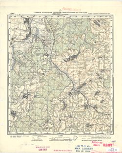
- Description:
- 1926
- Subject:
- Topical Subject: Soviet Union, Geographic Subject: Usvyata, and Topical Subject: Maps
- Publisher:
- Генеральный штаб РККА
- Language:
- Russian
- Identifier:
- VAC9619-001185
- Genre:
- Military Maps and Topographic Maps
- Geographic Location:
- Coordinates: 55.6667, 30.75, 55.8333, 31
- Related URL:
- Catalog URL: http://iucat.iu.edu/catalog/5020131 and Download GeoTIFF: https://drive.google.com/open?id=1LfDnjyQimu1w-GGzLKdUvdo_k8BYoSs-
- Abstract:
- Modern area represented: Usvyata, Pskov oblast, Russia
- Call Number:
- GM G7000 S50 .S68 Т-36-2-Г
- Caption:
- Не подлежит оглашению
- City:
- Усвяты (Usvyata)
- Copyright Holder:
- No Copyright - United States
- Country:
- СССР (USSR)
- State/Province:
- РСФСР (RSFSR) and Смоленская область (Smolensk oblast)
- Physical Description:
- Scale: 1:50,000
- Persistent URL:
- http://purl.dlib.indiana.edu/iudl/images/VAC9619/VAC9619-001185
- Provenance:
- Library of Congress Geography & Map Division
-
- Description:
- 1938
- Subject:
- Topical Subject: Maps, Geographic Subject: Khlystovo, and Topical Subject: Soviet Union
- Publisher:
- Главное управление геодезии и картографии при СНК СССР
- Language:
- Russian
- Date Created:
- 1941
- Identifier:
- VAC9619-003507
- Genre:
- Topographic Maps and Military Maps
- Geographic Location:
- Coordinates: 56, 33.75, 56.167, 34
- Related URL:
- Download GeoTIFF: https://drive.google.com/file/d/1fGG2lobcB7qv87HgHV3b9IjcaiO1TFwo/view?usp=sharing and Catalog URL: http://iucat.iu.edu/catalog/5020131
- Abstract:
- Modern area represented: Хлыстово (Khlystovo), Tverskaya oblast, Russia
- Call Number:
- GM G7000 s50 .S68 sheet O-36-140-D
- Caption:
- Captured map
- City:
- Хлыстово (Khlystovo)
- Copyright Holder:
- No Copyright - United States
- Country:
- СССР (USSR)
- State/Province:
- Оленинский район (Oleninsky district), Смоленская область (Smolensk oblast), Сычевский район (Sychevsky district), Калининская область (Kalinin oblast), and ...
- Physical Description:
- Scale: 1:50,000
- Persistent URL:
- http://purl.dlib.indiana.edu/iudl/images/VAC9619/VAC9619-003507
- Provenance:
- DMA Topographic Center, Army Map Service Library, Library of Congress Geography & Map Division
-
- Description:
- 1927
- Subject:
- Topical Subject: Maps, Topical Subject: Soviet Union, and Geographic Subject: Zapadnaya Dvina
- Publisher:
- Генеральный штаб Красной Армии
- Language:
- Russian
- Date Created:
- 1941
- Identifier:
- VAC9619-002233
- Genre:
- Military Maps and Topographic Maps
- Geographic Location:
- Coordinates: 56, 32, 56.3333, 32.5
- Related URL:
- Catalog URL: https://iucat.iu.edu/catalog/5020129 and Download GeoTIFF: https://drive.google.com/file/d/1ilppakufLs2qQPDjQwcVhMDRRILKyH-b/view?usp=sharing
- Abstract:
- Modern area represented: Западная Двина (Zapadnaya Dvina), Tverskaya oblast, Russia
- Call Number:
- G7000 s100 .S7 sheet O-36-137
- Caption:
- Captured map
- City:
- Западная Двина (Zapadnaya Dvina)
- Copyright Holder:
- No Copyright - United States
- Country:
- СССР (USSR)
- State/Province:
- Калининская область (Kalinin oblast), Смоленская область (Smolensk oblast), and РСФСР (RSFSR)
- Physical Description:
- Scale: 1:100,000
- Persistent URL:
- http://purl.dlib.indiana.edu/iudl/images/VAC9619/VAC9619-002233
- Provenance:
- DMA Topographic Center, Army Map Service Library
-
- Description:
- 1937
- Subject:
- Topical Subject: Maps, Topical Subject: Soviet Union, and Geographic Subject: Belev
- Publisher:
- Главное управление геодезии и картографии при СНК СССР
- Language:
- Russian
- Identifier:
- VAC9619-003139
- Genre:
- Topographic Maps and Military Maps
- Geographic Location:
- Coordinates: 53.667, 36, 54, 36.5
- Related URL:
- Catalog URL: https://iucat.iu.edu/catalog/5020129 and Download GeoTIFF: https://drive.google.com/file/d/1dC5B95Zg7rHaLuFhajznZpJAhrUivze3/view?usp=sharing
- Abstract:
- Modern area represented: Belev, Russia
- Call Number:
- G7000 s100 .S7 sheet N-37-73
- City:
- Белев (Belev)
- Copyright Holder:
- No Copyright - United States
- Country:
- СССР (USSR)
- State/Province:
- Орловская область (Oryol oblast), Тульская область (Tula oblast), Смоленская область (Smolensk oblast), and РСФСР (RSFSR)
- Physical Description:
- Scale: 1:100,000
- Persistent URL:
- http://purl.dlib.indiana.edu/iudl/images/VAC9619/VAC9619-003139
- Provenance:
- DMA Topographic Center, Army Map Service Library, OMAHA, Library of Congress Geography & Map Division, Auswärtiges Amt. Geographischer Dienst
-
- Subject:
- Geographic Subject: Chekalin, Topical Subject: Soviet Union, and Topical Subject: Maps
- Publisher:
- Генеральный штаб Красной Армии
- Language:
- Russian
- Date Created:
- 1941
- Identifier:
- VAC9619-003133
- Genre:
- Military Maps and Topographic Maps
- Geographic Location:
- Coordinates: 54, 36, 54.333, 36.5
- Related URL:
- Catalog URL: https://iucat.iu.edu/catalog/5020129 and Download GeoTIFF: https://drive.google.com/file/d/1ugls5OIU7HpPwWzo2KFpR0Mqwt9DQNx0/view?usp=sharing
- Abstract:
- Modern area represented: Чекалин (Chekalin), Tulskaya oblast, Russia
- Call Number:
- G7000 s100 .S7 sheet N-37-61
- Caption:
- Captured map
- City:
- Лихвин (Likhvin)
- Copyright Holder:
- No Copyright - United States
- Country:
- СССР (USSR)
- State/Province:
- РСФСР (RSFSR), Смоленская область (Smolensk oblast), and Тульская область (Tula oblast)
- Physical Description:
- Scale: 1:100,000
- Persistent URL:
- http://purl.dlib.indiana.edu/iudl/images/VAC9619/VAC9619-003133
- Provenance:
- DMA Topographic Center, Army Map Service Library
-
- Subject:
- Topical Subject: Maps, Geographic Subject: Detchino, and Topical Subject: Soviet Union
- Publisher:
- Генеральный штаб Красной Армии
- Language:
- Russian
- Identifier:
- VAC9619-003098
- Genre:
- Military Maps and Topographic Maps
- Geographic Location:
- Coordinates: 54.667, 36, 55, 36.5
- Related URL:
- Download GeoTIFF: https://drive.google.com/file/d/1mWVIAMrER6JmIWqtKxUE1lFRgPL9WvJ7/view?usp=sharing and Catalog URL: https://iucat.iu.edu/catalog/5020129
- Abstract:
- Modern area represented: Детчино (Detchino), Kaluzhskaya oblast, Russia
- Call Number:
- G7000 s100 .S7 sheet N-37-37
- City:
- Детчино (Detchino)
- Copyright Holder:
- No Copyright - United States
- Country:
- СССР (USSR)
- State/Province:
- Смоленская область (Smolensk oblast), Тульская область (Tula oblast), РСФСР (RSFSR), and Московская область (Moscow oblast)
- Physical Description:
- Scale: 1:100,000
- Persistent URL:
- http://purl.dlib.indiana.edu/iudl/images/VAC9619/VAC9619-003098
- Provenance:
- DMA Topographic Center, Army Map Service Library, OMAHA, Library of Congress Geography & Map Division
-
- Description:
- 1938
- Subject:
- Topical Subject: Maps, Geographic Subject: Vasilyevo, and Topical Subject: Soviet Union
- Publisher:
- Главное Управление Геодезии и Картографии при СНК СССР
- Language:
- Russian
- Date Created:
- 1941
- Identifier:
- VAC9619-001873
- Genre:
- Military Maps and Topographic Maps
- Geographic Location:
- Coordinates: 55.1667, 36, 55.3333, 36.25
- Related URL:
- Download GeoTIFF: https://drive.google.com/open?id=1K6w6CW9dTrPwudpPrBYVpbWjdNeeC133 and Catalog URL: http://iucat.iu.edu/catalog/5020131
- Abstract:
- Modern area represented: Vasilyevo, Russia
- Call Number:
- G7000 s50 .S68 sheet N-37-25-A
- City:
- Васильево (Vasilyevo)
- Copyright Holder:
- No Copyright - United States
- Country:
- СССР (USSR)
- State/Province:
- Московская область (Moscow oblast), РСФСР (RSFSR), and Смоленская область (Smolensk oblast)
- Physical Description:
- Scale: 1:50,000
- Persistent URL:
- http://purl.dlib.indiana.edu/iudl/images/VAC9619/VAC9619-001873
- Provenance:
- DMA Topographic Center, Army Map Service Library, OMAHA, Library of Congress Geography & Map Division
-
- Subject:
- Topical Subject: Maps, Geographic Subject: Maloyaroslavets, and Topical Subject: Soviet Union
- Publisher:
- Генеральный штаб Красной Армии
- Language:
- Russian
- Date Created:
- 1941
- Identifier:
- VAC9619-003085
- Genre:
- Military Maps and Topographic Maps
- Geographic Location:
- Coordinates: 55, 36, 55.333, 36.5
- Related URL:
- Download GeoTIFF: https://drive.google.com/file/d/1g83S8Lq1_QJVzohKxZO74PYsFtlVcXbF/view?usp=sharing and Catalog URL: https://iucat.iu.edu/catalog/5020129
- Abstract:
- Modern area represented: Малоярославец (Maloyaroslavets), Kaluzhskaya oblast, Russia
- Call Number:
- G7000 s100 .S7 sheet N-37-25
- Caption:
- Captured map
- City:
- Малоярославец (Maloyaroslavets)
- Copyright Holder:
- No Copyright - United States
- Country:
- СССР (USSR)
- State/Province:
- РСФСР (RSFSR), Смоленская область (Smolensk oblast), and Московская область (Moscow oblast)
- Physical Description:
- Scale: 1:100,000
- Persistent URL:
- http://purl.dlib.indiana.edu/iudl/images/VAC9619/VAC9619-003085
- Provenance:
- DMA Topographic Center, Army Map Service Library, OMAHA, Library of Congress Geography & Map Division
-
- Description:
- 1940
- Subject:
- Topical Subject: Maps, Geographic Subject: Lovat, and Topical Subject: Soviet Union
- Publisher:
- Главное Управление Геодезии и Картографии при СНК СССР
- Language:
- Russian
- Date Created:
- 1941
- Identifier:
- VAC9619-001469
- Genre:
- Topographic Maps and Military Maps
- Geographic Location:
- Coordinates: 53.5, 35, 53.6667, 35.25
- Related URL:
- Catalog URL: http://iucat.iu.edu/catalog/5020131 and Download GeoTIFF: https://drive.google.com/open?id=1CW7q_WmzCjxXip6vtnCVNXn4ufl3e4Yl
- Abstract:
- Modern area represented: Lovat, Kaluga, Russia
- Call Number:
- G7000 s50 .S68 sheet N-36-95-A
- Caption:
- Для служебного пользования
- City:
- Ловать (Lovat)
- Copyright Holder:
- No Copyright - United States
- Country:
- СССР (USSR)
- State/Province:
- Орловская область (Oryol oblast), РСФСР (RSFSR), and Смоленская область (Smolensk oblast)
- Physical Description:
- Scale: 1:50,000
- Persistent URL:
- http://purl.dlib.indiana.edu/iudl/images/VAC9619/VAC9619-001469
- Provenance:
- DMA Topographic Center, Army Map Service Library, OMAHA, Library of Congress Geography & Map Division
-
- Description:
- 1930
- Subject:
- Geographic Subject: Kletnya, Topical Subject: Soviet Union, and Topical Subject: Maps
- Publisher:
- Генеральный штаб Красной Армии
- Language:
- Russian
- Date Created:
- 1934
- Identifier:
- VAC9619-001453
- Genre:
- Topographic Maps and Military Maps
- Geographic Location:
- Coordinates: 53.3333, 33, 53.5, 33.25
- Related URL:
- Catalog URL: http://iucat.iu.edu/catalog/5020131 and Download GeoTIFF: https://drive.google.com/open?id=1oFXwGvIb9ojTDiTojklq9euajSXb2KgV
- Abstract:
- Modern area represented: Kletnya, Bryansk oblast, Russia
- Call Number:
- GM G7000 S50 .S68 N-36-91-В
- City:
- Клетня (Kletnya)
- Copyright Holder:
- No Copyright - United States
- Country:
- СССР (USSR)
- State/Province:
- Орловская область (Oryol oblast), РСФСР (RSFSR), and Смоленская область (Smolensk oblast)
- Physical Description:
- Scale: 1:50,000
- Persistent URL:
- http://purl.dlib.indiana.edu/iudl/images/VAC9619/VAC9619-001453
- Provenance:
- DMA Topographic Center, Army Map Service Library, Library of Congress Geography & Map Division
-
- Description:
- 1930
- Subject:
- Geographic Subject: Dengubovka, Topical Subject: Soviet Union, and Topical Subject: Maps
- Publisher:
- Генеральный штаб РККА
- Language:
- Russian
- Identifier:
- VAC9619-001451
- Genre:
- Topographic Maps and Military Maps
- Geographic Location:
- Coordinates: 53.5, 33, 53.6667, 33.25
- Related URL:
- Download GeoTIFF: https://drive.google.com/open?id=1KATAyPHstxiTa8so6QD3XBg2HvD6rN1U and Catalog URL: http://iucat.iu.edu/catalog/5020131
- Abstract:
- Modern area represented: Dengubovka, Bryansk oblast, Russia
- Call Number:
- GM G7000 S50 .S68 N-36-91-A
- City:
- Деньгубовка (Dengubovka)
- Copyright Holder:
- No Copyright - United States
- Country:
- СССР (USSR)
- State/Province:
- Орловская область (Oryol oblast), РСФСР (RSFSR), and Смоленская область (Smolensk oblast)
- Physical Description:
- Scale: 1:50,000
- Persistent URL:
- http://purl.dlib.indiana.edu/iudl/images/VAC9619/VAC9619-001451
- Provenance:
- DMA Topographic Center, Army Map Service Library, OMAHA, Library of Congress Geography & Map Division
-
- Description:
- 1930
- Subject:
- Topical Subject: Maps, Topical Subject: Soviet Union, and Geographic Subject: Kletnya
- Publisher:
- Генеральный штаб Красной Армии
- Language:
- Russian
- Date Created:
- 1941
- Identifier:
- VAC9619-001938
- Genre:
- Topographic Maps and Military Maps
- Geographic Location:
- Coordinates: 53.3333, 33, 53.6667, 33.5
- Related URL:
- Catalog URL: https://iucat.iu.edu/catalog/5020129 and Download GeoTIFF: https://drive.google.com/open?id=1I7e3zKT-6rPruvnEwrI8_h-Iih4QFvCi
- Abstract:
- Modern area represented: Клетня (Kletnya), Bryanskaya oblast, Russia
- Call Number:
- G7000 s100 .S7 sheet N-36-91
- Caption:
- Для служебного пользования
- City:
- Клетня (Kletnya)
- Copyright Holder:
- No Copyright - United States
- Country:
- СССР (USSR)
- State/Province:
- РСФСР (RSFSR), Смоленская область (Smolensk oblast), and Орловская область (Oryol oblast)
- Physical Description:
- Scale: 1:100,000
- Persistent URL:
- http://purl.dlib.indiana.edu/iudl/images/VAC9619/VAC9619-001938
- Provenance:
- DMA Topographic Center, Army Map Service Library, OMAHA, Library of Congress Geography & Map Division
-
- Description:
- 1931
- Subject:
- Topical Subject: Maps, Topical Subject: Soviet Union, and Geographic Subject: Khotsimsk
- Publisher:
- Генеральный штаб Красной Армии
- Language:
- Russian
- Date Created:
- 1941
- Identifier:
- VAC9619-001937
- Genre:
- Topographic Maps and Military Maps
- Geographic Location:
- Coordinates: 53.3333, 32.5, 53.6667, 33
- Related URL:
- Catalog URL: https://iucat.iu.edu/catalog/5020129 and Download GeoTIFF: https://drive.google.com/open?id=1ZS128aTIWIj2T-V2a8GCE9BsBAJiJGgB
- Abstract:
- Modern area represented: Хоцімск (Khotsimsk), Mogilev district, Belarus
- Call Number:
- G7000 s100 .S7 sheet N-36-90
- City:
- Хотимск (Khotimsk)
- Copyright Holder:
- No Copyright - United States
- Country:
- СССР (USSR)
- State/Province:
- РСФСР (RSFSR), Могилевская область (Mogilev oblast), Белорусская ССР (Byelorussian Soviet Socialist Republic), Орловская область (Oryol oblast), and Смоленск...
- Physical Description:
- Scale: 1:100,000
- Persistent URL:
- http://purl.dlib.indiana.edu/iudl/images/VAC9619/VAC9619-001937
- Provenance:
- DMA Topographic Center, Army Map Service Library, OMAHA, Library of Congress Geography & Map Division
-
- Description:
- 1939
- Subject:
- Topical Subject: Soviet Union, Topical Subject: Maps, and Geographic Subject: Sychovka
- Publisher:
- Главное Управление Геодезии и Картографии при СНК СССР
- Language:
- Russian
- Date Created:
- 1941
- Identifier:
- VAC9619-001209
- Genre:
- Topographic Maps and Military Maps
- Geographic Location:
- Coordinates: 55.8333, 34.25, 56, 34.5
- Related URL:
- Download GeoTIFF: https://drive.google.com/open?id=1q_RTxgnqo0jETuLOMqmoh973Pqv0GNIa and Catalog URL: http://iucat.iu.edu/catalog/5020131
- Abstract:
- Modern area represented: Sychovka, Smolensk oblast, Russia
- Call Number:
- GM G7000 S50 .S68 N-36-9-Б
- Copyright Holder:
- No Copyright - United States
- Country:
- СССР (USSR)
- State/Province:
- РСФСР (RSFSR), Калининская область (Kalinin oblast), and Смоленская область (Smolensk oblast)
- Physical Description:
- Scale: 1:50,000
- Persistent URL:
- http://purl.dlib.indiana.edu/iudl/images/VAC9619/VAC9619-001209
- Provenance:
- DMA Topographic Center, Army Map Service Library, OMAHA, Library of Congress Geography & Map Division
-
- Description:
- 1939
- Subject:
- Geographic Subject: Kaurovo, Topical Subject: Maps, and Topical Subject: Soviet Union
- Publisher:
- Главное Управление Геодезии и Картографии при СНК СССР
- Language:
- Russian
- Date Created:
- 1941
- Identifier:
- VAC9619-001210
- Genre:
- Topographic Maps and Military Maps
- Geographic Location:
- Coordinates: 55.6667, 34, 55.8333, 34.25
- Related URL:
- Catalog URL: http://iucat.iu.edu/catalog/5020131 and Download GeoTIFF: https://drive.google.com/open?id=1BPGpdIbbavrmwENARn9C4mq_uVMkak4i
- Abstract:
- Modern area represented: Kaurovo, Smolensk oblast, Russia
- Call Number:
- GM G7000 S50 .S68 N-36-9-B
- Copyright Holder:
- No Copyright - United States
- Country:
- СССР (USSR)
- State/Province:
- Смоленская область (Smolensk oblast) and РСФСР (RSFSR)
- Physical Description:
- Scale: 1:50,000
- Persistent URL:
- http://purl.dlib.indiana.edu/iudl/images/VAC9619/VAC9619-001210
- Provenance:
- DMA Topographic Center, Army Map Service Library, OMAHA, Library of Congress Geography & Map Division
-
- Description:
- 1939
- Subject:
- Geographic Subject: Sychevka, Topical Subject: Maps, and Topical Subject: Soviet Union
- Publisher:
- Генеральный штаб Красной Армии
- Language:
- Russian
- Date Created:
- 1941
- Identifier:
- VAC9619-003062
- Genre:
- Topographic Maps and Military Maps
- Geographic Location:
- Coordinates: 55.667, 34, 56, 34.5
- Related URL:
- Catalog URL: https://iucat.iu.edu/catalog/5020129 and Download GeoTIFF: https://drive.google.com/file/d/1gblwoAOQEZjmkqeDb6dK1pp3mPvMc0h4/view?usp=sharing
- Abstract:
- Modern area represented: Сычевка (Sychevka), Smolenskaya oblast, Russia
- Call Number:
- G7000 s100 .S7 sheet N-36-9
- Caption:
- Captured map
- City:
- Сычевка (Sychevka)
- Copyright Holder:
- No Copyright - United States
- Country:
- СССР (USSR)
- State/Province:
- Калининская область (Kalinin oblast), РСФСР (RSFSR), and Смоленская область (Smolensk oblast)
- Physical Description:
- Scale: 1:100,000
- Persistent URL:
- http://purl.dlib.indiana.edu/iudl/images/VAC9619/VAC9619-003062
- Provenance:
- DMA Topographic Center, Army Map Service Library, OMAHA, Auswärtiges Amt. Geographischer Dienst
-
- Subject:
- Geographic Subject: Kastsyukovichy, Topical Subject: Soviet Union, and Topical Subject: Maps
- Publisher:
- Генеральный штаб Красной Армии
- Language:
- Russian
- Date Created:
- 1941
- Identifier:
- VAC9619-001936
- Genre:
- Military Maps and Topographic Maps
- Geographic Location:
- Coordinates: 53.3333, 32, 53.6667, 32.5
- Related URL:
- Catalog URL: https://iucat.iu.edu/catalog/5020129 and Download GeoTIFF: https://drive.google.com/open?id=17diw8XEAG5Pvf2BuHqhMeKVNoc3ttEnL
- Abstract:
- Modern area represented: Касцюковічы (Kastsyukovichy), Mogilev district, Belarus
- Call Number:
- G7000 s100 .S7 sheet N-36-89
- City:
- Костюковичи (Kostyukovichi)
- Copyright Holder:
- No Copyright - United States
- Country:
- СССР (USSR)
- State/Province:
- РСФСР (RSFSR), Могилевская область (Mogilev oblast), Смоленская область (Smolensk oblast), and Белорусская ССР (Byelorussian Soviet Socialist Republic)
- Physical Description:
- Scale: 1:100,000
- Persistent URL:
- http://purl.dlib.indiana.edu/iudl/images/VAC9619/VAC9619-001936
- Provenance:
- DMA Topographic Center, Army Map Service Library
-
- Description:
- 1940
- Subject:
- Geographic Subject: Veyno, Topical Subject: Maps, and Topical Subject: Soviet Union
- Publisher:
- Главное Управление Геодезии и Картографии при СНК СССР
- Language:
- Russian
- Date Created:
- 1941
- Identifier:
- VAC9619-001431
- Genre:
- Military Maps and Topographic Maps
- Geographic Location:
- Coordinates: 53.6667, 35.75, 53.8667, 36
- Related URL:
- Catalog URL: http://iucat.iu.edu/catalog/5020131 and Download GeoTIFF: https://drive.google.com/open?id=1grHJ7pHQUKP1whRZxmXF7b1IKLZRXyb_
- Abstract:
- Modern area represented: Veyno, Kaluga oblast, Russia
- Call Number:
- GM G7000 S50 .S68 N-36-84-Г
- City:
- Вейно (Veyno)
- Copyright Holder:
- No Copyright - United States
- Country:
- СССР (USSR)
- State/Province:
- Орловская область (Oryol oblast), Тульская область (Tula oblast), РСФСР (RSFSR), and Смоленская область (Smolensk oblast)
- Physical Description:
- Scale: 1:50,000
- Persistent URL:
- http://purl.dlib.indiana.edu/iudl/images/VAC9619/VAC9619-001431
- Provenance:
- Library of Congress Geography & Map Division, Army Map Service Library, OMAHA
-
- Description:
- 1940
- Subject:
- Topical Subject: Soviet Union, Topical Subject: Maps, and Geographic Subject: Ulyanovo Pervoye
- Publisher:
- Главное Управление Геодезии и Картографии при СНК СССР
- Language:
- Russian
- Date Created:
- 1941
- Identifier:
- VAC9619-001430
- Genre:
- Military Maps and Topographic Maps
- Geographic Location:
- Coordinates: 53.6667, 35.5, 53.8667, 35.75
- Related URL:
- Download GeoTIFF: https://drive.google.com/open?id=1HStfzuna63UxK3qn1yGJwA7tEgvWsEXB and Catalog URL: http://iucat.iu.edu/catalog/5020131
- Abstract:
- Modern area represented: Ulyanovo Pervoye, Kaluga oblast, Russia
- Call Number:
- GM G7000 S50 .S68 N-36-84-В
- City:
- Ульяново 1-ое (Ulyanovo Pervoye)
- Copyright Holder:
- No Copyright - United States
- Country:
- СССР (USSR)
- State/Province:
- Смоленская область (Smolensk oblast), Орловская область (Oryol oblast), and РСФСР (RSFSR)
- Physical Description:
- Scale: 1:50,000
- Persistent URL:
- http://purl.dlib.indiana.edu/iudl/images/VAC9619/VAC9619-001430
- Provenance:
- DMA Topographic Center, Army Map Service Library, OMAHA, Library of Congress Geography & Map Division
-
- Description:
- 1940
- Subject:
- Topical Subject: Soviet Union, Geographic Subject: Slagovishchi, and Topical Subject: Maps
- Publisher:
- Главное Управление Геодезии и Картографии при СНК СССР
- Language:
- Russian
- Date Created:
- 1941
- Identifier:
- VAC9619-001429
- Genre:
- Topographic Maps and Military Maps
- Geographic Location:
- Coordinates: 53.833, 35.75, 54, 36
- Related URL:
- Catalog URL: http://iucat.iu.edu/catalog/5020131 and Download GeoTIFF: https://drive.google.com/open?id=1oqQ_Jwap6JQmn5gSc_0feHfoVhOgIhSE
- Abstract:
- Modern area represented: Slagovishchi, Kaluga oblast, Russia
- Call Number:
- GM G7000 S50 .S68 N-36-84-B
- City:
- Слаговищи (Slagovishchi)
- Copyright Holder:
- No Copyright - United States
- Country:
- СССР (USSR)
- State/Province:
- РСФСР (RSFSR), Тульская область (Tula oblast), and Смоленская область (Smolensk oblast)
- Physical Description:
- Scale: 1:50,000
- Persistent URL:
- http://purl.dlib.indiana.edu/iudl/images/VAC9619/VAC9619-001429
- Provenance:
- G000-30, Atlasblatt, CIA Map Library, M. I. Map Library
