
Search Constraints
You searched for:
Campus
IUB
Remove constraint Campus: IUB
Collections
Charles W. Cushman Kodachrome Slides
Remove constraint Collections: Charles W. Cushman Kodachrome Slides
Pages
0-99 pages
Remove constraint Pages: 0-99 pages
Subject
Mountains
Remove constraint Subject: Mountains
Subject
Shrubs
Remove constraint Subject: Shrubs
« Previous |
1 - 100 of 1,198
|
Next »
Search Results
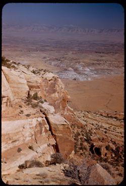
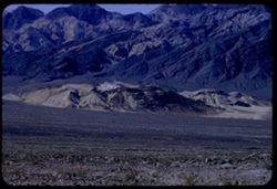
-
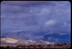
- Description:
- 100 f 8 tl
- Subject:
- Hills, Funeral Mountains (Calif.), Funeral Mountains Wilderness (Calif.), Mountains, Shrubs, Furnace Creek (Calif.), Rocks, and Clouds
- Series:
- 2-55
- Creator:
- Cushman, Charles W., 1896-1972
- Date Created:
- 1955-02-27
- Genre:
- Landscape photographs
- Frame Number:
- 29
- Street Address:
- Furance Creek-Death Valley Junction Road
- County:
- Mono and Inyo
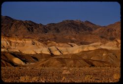
- Abstract:
- North toward Funeral Mtns
- Call Number:
- P07586
- City:
- Death Valley Junction
- Country:
- United States
- State/Province:
- California
- Alternate Identifier:
- 255.29
- Persistent URL:
- http://purl.dlib.indiana.edu/iudl/archives/cushman/P07586
-
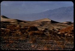
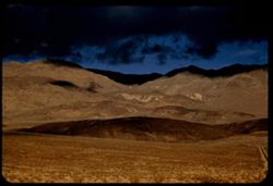
- Description:
- 100 f 7 tl
- Subject:
- Valleys, Death Valley (Calif. and Nev.), Mountains, Shrubs, and Dunes
- Series:
- 3-55
- Creator:
- Cushman, Charles W., 1896-1972
- Date Created:
- 1955-02-27
- Genre:
- Landscape photographs
- Frame Number:
- 25
- County:
- Inyo
- Abstract:
- Sand Dunes near Stove Pipe Wells
- Call Number:
- P07616
- City:
- Stovepipe Wells
- Country:
- United States
- State/Province:
- California
- Alternate Identifier:
- 355.25
- Persistent URL:
- http://purl.dlib.indiana.edu/iudl/archives/cushman/P07616
-
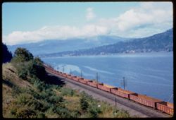
- Description:
- 50 f 6.3
- Subject:
- Railroad freight cars, Union Pacific Railroad Company, Columbia River, Railroad cars, Railroad tracks, Mountains, Utility poles, Electric lines, Trees, Cloud...
- Series:
- 25-60
- Creator:
- Cushman, Charles W., 1896-1972
- Date Created:
- 1960-09-25
- Genre:
- Landscape photographs
- Frame Number:
- 10
- County:
- Hood River
- Abstract:
- Cloud mass above Columbia 16 mi w. of H.R.
- Call Number:
- P11698
- City:
- Hood River
- Country:
- United States
- State/Province:
- Oregon
- Alternate Identifier:
- 2560.10
- Persistent URL:
- http://purl.dlib.indiana.edu/iudl/archives/cushman/P11698
-
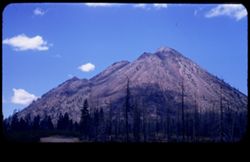
- Description:
- 50 f 8
- Subject:
- Black Butte (Siskiyou County, Calif.), Lava domes, Lassen Volcanic National Park (Calif.), Volcanic domes, Mountains, Shrubs, Trees, Cascade Range, Buttes, C...
- Series:
- 6-54
- Creator:
- Cushman, Charles W., 1896-1972
- Date Created:
- 1954-08-20
- Genre:
- Landscape photographs
- Frame Number:
- 26
- County:
- Siskiyou
- Abstract:
- That same triple cone (Black Butte) west of Mt Shasta.
- Call Number:
- P07243
- Country:
- United States
- State/Province:
- California
- Physical Description:
- masked.
- Alternate Identifier:
- 654.26
- Persistent URL:
- http://purl.dlib.indiana.edu/iudl/archives/cushman/P07243
-
- Description:
- 25 f 8 Pola
- Subject:
- Colorado River Valley (Colo.-Mexico), National parks & reserves, Deserts, Valleys, Colorado National Monument (Colo.), Cliffs, Mountains, Shrubs, Buttes,...
- Series:
- 26-52
- Creator:
- Cushman, Charles W., 1896-1972
- Date Created:
- 1952-11-03
- Genre:
- Landscape photographs
- Frame Number:
- 6
- County:
- Mesa
- Abstract:
- View down [P] across buttes + valley of Colo. River.
- Call Number:
- P06413
- City:
- Grand Junction
- Country:
- United States
- State/Province:
- Colorado
- Alternate Identifier:
- 2652.6
- Persistent URL:
- http://purl.dlib.indiana.edu/iudl/archives/cushman/P06413
-
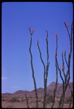
- Description:
- 100 f 8 tl
- Subject:
- Deserts, Flowers, Ocotillo, Mountains, Shrubs, and Clouds
- Series:
- 11-59
- Creator:
- Cushman, Charles W., 1896-1972
- Date Created:
- 1959-03-24
- Genre:
- Identification photographs
- Frame Number:
- 11
- County:
- Yuma and Riverside
- Abstract:
- Our finest ocotillo - 15-20 mi east of Blythe
- Call Number:
- P10736
- City:
- Blythe and Quartzsite
- Country:
- United States
- State/Province:
- Arizona and California
- Alternate Identifier:
- 1159.11
- Persistent URL:
- http://purl.dlib.indiana.edu/iudl/archives/cushman/P10736
-
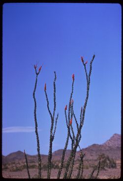
- Description:
- 250 f 5.6
- Subject:
- Deserts, Flowers, Ocotillo, Mountains, Shrubs, and Clouds
- Series:
- 11-59
- Creator:
- Cushman, Charles W., 1896-1972
- Date Created:
- 1959-03-24
- Genre:
- Identification photographs
- Frame Number:
- 12
- County:
- Yuma and Riverside
- Abstract:
- Our finest ocotillo - 15-20 mi east of Blythe
- Call Number:
- P10737
- City:
- Blythe and Quartzsite
- Country:
- United States
- State/Province:
- Arizona and California
- Alternate Identifier:
- 1159.12
- Persistent URL:
- http://purl.dlib.indiana.edu/iudl/archives/cushman/P10737
-
- Description:
- 50 f 11
- Subject:
- Hills, Mountains, Shrubs, Trees, Buttes, and Fences
- Series:
- 18-52
- Creator:
- Cushman, Charles W., 1896-1972
- Date Created:
- 1952-04-15
- Genre:
- Landscape photographs
- Frame Number:
- 29
- Street Address:
- Los Alamos Road
- County:
- Santa Fe
- Abstract:
- View west from same pt as 27.
- Call Number:
- P06160
- City:
- Santa Fe
- Country:
- United States
- State/Province:
- New Mexico
- Alternate Identifier:
- 1852.29
- Persistent URL:
- http://purl.dlib.indiana.edu/iudl/archives/cushman/P06160
-
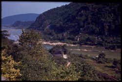
- Subject:
- Jefferson Rock (W. Va.), Railroad tracks, Potomac River, Shrubs, Trees, Rivers, Mountains, and Shenandoah River (Va. and W. Va.)
- Series:
- 16-40
- Creator:
- Cushman, Charles W., 1896-1972
- Date Created:
- 1940-09-16/1940-09-23
- Genre:
- Landscape photographs
- Frame Number:
- 13
- County:
- Jefferson
- Abstract:
- Confluence at Shenandoah and Potomac from Jefferson Rock, Harpers Ferry
- Call Number:
- P02062
- City:
- Harpers Ferry
- Country:
- United States
- State/Province:
- West Virginia
- Physical Description:
- Image was originally mounted in a glass enclosure. Before digitization, the image was removed and placed in a Wess Plastic, Inc. brand, 2" x 2", pl...
- Alternate Identifier:
- 1640.13
- Persistent URL:
- http://purl.dlib.indiana.edu/iudl/archives/cushman/P02062
-
- Description:
- 50 f 8
- Subject:
- Lakes & ponds, Almanor, Lake (Calif.), Bodies of water, Mountains, Shrubs, Trees, Cascade Range, Reservoirs, and Pines
- Series:
- 7-54
- Creator:
- Cushman, Charles W., 1896-1972
- Date Created:
- 1954-08-21
- Genre:
- Landscape photographs
- Frame Number:
- 10
- Street Address:
- California State Highway 36
- County:
- Plumas
- Abstract:
- Lake Almanor from Cal 36.
- Call Number:
- P07265
- Country:
- United States
- State/Province:
- California
- Alternate Identifier:
- 754.10
- Persistent URL:
- http://purl.dlib.indiana.edu/iudl/archives/cushman/P07265
-
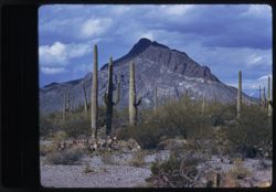
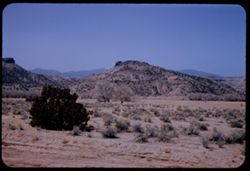
- Description:
- 100 f 8
- Subject:
- Mountains, Tucson Mountains (Ariz.), Shrubs, Cactus, and Clouds
- Series:
- 7-59
- Creator:
- Cushman, Charles W., 1896-1972
- Date Created:
- 1959-02-02
- Genre:
- Landscape photographs
- Frame Number:
- 2
- Street Address:
- Ajo Way
- County:
- Pima
- Abstract:
- a Tucson mtn. from SE
- Call Number:
- P10578
- City:
- Tucson
- Country:
- United States
- State/Province:
- Arizona
- Physical Description:
- masked.
- Alternate Identifier:
- 759.2
- Persistent URL:
- http://purl.dlib.indiana.edu/iudl/archives/cushman/P10578
-
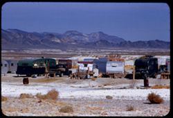
- Description:
- 100 f 8 + tl
- Subject:
- Minerals, Trucks, Valleys, Mountains, Shrubs, Tecopa Hot Springs (Calif.), and Trailers
- Series:
- 12-55
- Creator:
- Cushman, Charles W., 1896-1972
- Date Created:
- 1955-03-24
- Genre:
- Views
- Frame Number:
- 6
- County:
- Inyo
- Abstract:
- Trailer colony near Tecopa Hot Springs
- Call Number:
- P07902
- Country:
- United States
- State/Province:
- California
- Alternate Identifier:
- 1255.6
- Persistent URL:
- http://purl.dlib.indiana.edu/iudl/archives/cushman/P07902
-
- Description:
- 50 f 7 Pola
- Subject:
- Sangre de Cristo Mountains (Colo. and N.M.), Hills, Barbed wire, Cliffs, Mountains, Shrubs, Snow, and Fences
- Series:
- 18-52
- Creator:
- Cushman, Charles W., 1896-1972
- Date Created:
- 1952-04-15
- Genre:
- Landscape photographs
- Frame Number:
- 31
- Street Address:
- Highway 84
- County:
- Santa Fe
- Abstract:
- Again - from Hwy 84.
- Call Number:
- P06162
- City:
- Santa Fe
- Country:
- United States
- State/Province:
- New Mexico
- Alternate Identifier:
- 1852.31
- Persistent URL:
- http://purl.dlib.indiana.edu/iudl/archives/cushman/P06162
-
- Description:
- 25 f 11
- Subject:
- National parks & reserves, Pulliam Peak (Tex.), Green Gulch (Tex.), Valleys, Cliffs, Big Bend National Park (Tex.), Mountains, Shrubs, Basin (Big Bend Na...
- Series:
- 16-51
- Creator:
- Cushman, Charles W., 1896-1972
- Date Created:
- 1951-12-27
- Genre:
- Landscape photographs
- Frame Number:
- 4
- County:
- Brewster
- Abstract:
- Great bold front of Pulliam Pk. from Green gulch
- Call Number:
- P05423
- Country:
- United States
- State/Province:
- Texas
- Alternate Identifier:
- 1651.4
- Persistent URL:
- http://purl.dlib.indiana.edu/iudl/archives/cushman/P05423
-
- Description:
- 100 f 6.3 tl
- Subject:
- Domes, Cities & towns, Streets, Automobiles, Mountains, Tucson Mountains (Ariz.), Shrubs, Trees, Buildings, Signs (Notices), Clouds, and Dwellings
- Series:
- 8-59
- Creator:
- Cushman, Charles W., 1896-1972
- Date Created:
- 1959-02-11
- Genre:
- Cityscape photographs
- Frame Number:
- 4
- County:
- Pima
- Abstract:
- Tucson from A Mtn.
- Call Number:
- P10618
- City:
- Tucson
- Country:
- United States
- State/Province:
- Arizona
- Alternate Identifier:
- 859.4
- Persistent URL:
- http://purl.dlib.indiana.edu/iudl/archives/cushman/P10618
-
- Description:
- 50 f 8
- Subject:
- Plains, Mountains, Dirt roads, Shrubs, Sierra Blanca Mountains (Tex.), and Grasses
- Series:
- 12-53
- Creator:
- Cushman, Charles W., 1896-1972
- Date Created:
- 1953-11-15
- Genre:
- Landscape photographs
- Frame Number:
- 36
- County:
- Hudspeth
- Abstract:
- Sierra Blanca Mtn. (7000 ft)
- Call Number:
- P06954
- City:
- Sierra Blanca
- Country:
- United States
- State/Province:
- Texas
- Alternate Identifier:
- 1253.36
- Persistent URL:
- http://purl.dlib.indiana.edu/iudl/archives/cushman/P06954
-
- Description:
- 100 f 8 tl
- Subject:
- Flowers, Mountains, and Shrubs
- Series:
- 11-59
- Creator:
- Cushman, Charles W., 1896-1972
- Date Created:
- 1959-03-24
- Genre:
- Landscape photographs
- Frame Number:
- 6
- County:
- Yuma
- Abstract:
- RM Mtns
- Call Number:
- P10731
- City:
- Quartzsite
- Country:
- United States
- State/Province:
- Arizona
- Alternate Identifier:
- 1159.6
- Persistent URL:
- http://purl.dlib.indiana.edu/iudl/archives/cushman/P10731
-

- Description:
- 100 f 5.6
- Subject:
- Steeples, Cathedrals, Mirabellgarten (Salzburg, Austria), Pedestrians, Forts & fortifications, Mountains, Shrubs, Fountains, Trees, Gates, Festung Hohens...
- Series:
- 8-64
- Creator:
- Cushman, Charles W., 1896-1972
- Date Created:
- 1964-05-21
- Genre:
- Cityscape photographs and Views
- Frame Number:
- 4
- Abstract:
- Hohensalzberg Fortress from Mirabell Garden
- Call Number:
- P13206
- City:
- Salzburg
- Country:
- Austria
- State/Province:
- Salzburg
- Alternate Identifier:
- 864.4
- Persistent URL:
- http://purl.dlib.indiana.edu/iudl/archives/cushman/P13206
-
- Description:
- 50 f 8 Pola
- Subject:
- Passes (Landforms), Roads, Mountains, Shrubs, Snow, Trees, Rocks, Kenosha Pass (Colo.), Railings, Kenosha Mountains (Colo.), and Clouds
- Series:
- 10-53
- Creator:
- Cushman, Charles W., 1896-1972
- Date Created:
- 1953-10-14
- Genre:
- Landscape photographs
- Frame Number:
- 22
- County:
- Park
- Abstract:
- NE from Kenosha Pass
- Call Number:
- P06862
- Country:
- United States
- State/Province:
- Colorado
- Alternate Identifier:
- 1053.22
- Persistent URL:
- http://purl.dlib.indiana.edu/iudl/archives/cushman/P06862
-
- Subject:
- Mount Rainier National Park (Wash.), National parks & reserves, Forests, Mountains, Shrubs, Trees, and Rocks
- Series:
- 4-38
- Creator:
- Cushman, Charles W., 1896-1972
- Date Created:
- 1938-09-21/1938-09-22
- Genre:
- Landscape photographs
- Frame Number:
- 34
- Abstract:
- D-34= Mountain scene near Chinook Pass.
- Call Number:
- P01463
- Country:
- United States
- State/Province:
- Washington
- Physical Description:
- Color corrected: magenta cast [fading of yellow dye]. Image was originally mounted in a glass enclosure. Before digitization, the image was removed and place...
- Alternate Identifier:
- 438.34
- Persistent URL:
- http://purl.dlib.indiana.edu/iudl/archives/cushman/P01463
-
- Description:
- 25 f 6.3
- Subject:
- Hills, Mountains, Shrubs, Colorado River (Colo.-Mexico), and Rivers
- Series:
- 25-52
- Creator:
- Cushman, Charles W., 1896-1972
- Date Created:
- 1952-11-02
- Genre:
- Landscape photographs
- Frame Number:
- 28
- County:
- Garfield
- Abstract:
- Colorado river 16 mi. east of Glenwood Springs.
- Call Number:
- P06397
- City:
- Glenwood Springs
- Country:
- United States
- State/Province:
- Colorado
- Alternate Identifier:
- 2552.28
- Persistent URL:
- http://purl.dlib.indiana.edu/iudl/archives/cushman/P06397
-
- Subject:
- Lakes & ponds, Mountains, Dirt roads, Shrubs, Rocks, Coastlines, Clouds, and Walker Lake
- Series:
- 10-40
- Creator:
- Cushman, Charles W., 1896-1972
- Date Created:
- 1940-07-09
- Genre:
- Landscape photographs
- Frame Number:
- 5
- County:
- Mineral
- Call Number:
- P01927
- Country:
- United States
- State/Province:
- Nevada
- Physical Description:
- Image was originally mounted in a glass enclosure. Before digitization, the image was removed and placed in a Wess Plastic, Inc. brand, 2" x 2", pl...
- Alternate Identifier:
- 1040.5
- Persistent URL:
- http://purl.dlib.indiana.edu/iudl/archives/cushman/P01927
-
- Description:
- 50 f 6.3 pola
- Subject:
- Cliffs, Mountains, Shrubs, Santa Catalina Mountains (Ariz.), Boulders, Rock formations, and Clouds
- Series:
- 4-52
- Creator:
- Cushman, Charles W., 1896-1972
- Date Created:
- 1952-01-25
- Genre:
- Landscape photographs
- Frame Number:
- 20
- Street Address:
- Mount Lemmon Road
- Abstract:
- View toward Santa Catalina tops westward
- Call Number:
- P05626
- Country:
- United States
- State/Province:
- Arizona
- Alternate Identifier:
- 452.20
- Persistent URL:
- http://purl.dlib.indiana.edu/iudl/archives/cushman/P05626
-
- Description:
- 100 f 9 tl
- Subject:
- Roskruge Mountains (Ariz.), Mountains, and Shrubs
- Series:
- 8-59
- Creator:
- Cushman, Charles W., 1896-1972
- Date Created:
- 1959-02-20
- Genre:
- Landscape photographs
- Frame Number:
- 34
- Street Address:
- Ajo Way
- County:
- Pima
- Abstract:
- A single beauty
- Call Number:
- P10648
- Country:
- United States
- State/Province:
- Arizona
- Alternate Identifier:
- 859.34
- Persistent URL:
- http://purl.dlib.indiana.edu/iudl/archives/cushman/P10648
-
- Description:
- 100 f 8 tl
- Subject:
- Baboquivari Peak (Ariz.), Mountains, Shrubs, Cactus, and Topara
- Series:
- 8-59
- Creator:
- Cushman, Charles W., 1896-1972
- Date Created:
- 1959-02-20
- Genre:
- Landscape photographs
- Frame Number:
- 37
- County:
- Pima
- Abstract:
- Babaoquivari from road south of Topara
- Call Number:
- P10651
- Country:
- United States
- State/Province:
- Arizona
- Alternate Identifier:
- 859.37
- Persistent URL:
- http://purl.dlib.indiana.edu/iudl/archives/cushman/P10651
-
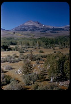
- Description:
- 50 f 9
- Subject:
- Sheep, Hills, Mountains, Shrubs, Sierra Nevada (Calif. and Nev.), Trees, Grazing, Grasses, and Dunderberg Peak (Calif.)
- Series:
- 9-54
- Creator:
- Cushman, Charles W., 1896-1972
- Date Created:
- 1954-09-16
- Genre:
- Landscape photographs
- Frame Number:
- 20
- Street Address:
- United States Highway 395
- County:
- Mono
- Abstract:
- Sheep below - looking toward Dunderberg Pk. (19-20-21 were taken less than mile north of Conway Summit)
- Call Number:
- P07331
- City:
- Bridgeport
- Country:
- United States
- State/Province:
- California
- Physical Description:
- masked.
- Alternate Identifier:
- 954.20
- Persistent URL:
- http://purl.dlib.indiana.edu/iudl/archives/cushman/P07331
-
- Description:
- 50 f 8
- Subject:
- Hills, Roads, Franklin Mountains (Tex. and N.M.), Mountains, Shrubs, Shadows, and Clouds
- Series:
- 17-51
- Creator:
- Cushman, Charles W., 1896-1972
- Date Created:
- 1952-01-01
- Genre:
- Landscape photographs
- Frame Number:
- 30
- County:
- El Paso
- Abstract:
- Whorls on a Mtn. side = Franklin Mtns.
- Call Number:
- P05481
- City:
- El Paso
- Country:
- United States
- State/Province:
- Texas
- Alternate Identifier:
- 1751.30
- Persistent URL:
- http://purl.dlib.indiana.edu/iudl/archives/cushman/P05481
-
- Description:
- 25 f 9 Pola
- Subject:
- Whitney, Mount (Calif.), Mountains, Shrubs, Snow, Trees, Rocks, Portal station, Rock formations, and Boulders
- Series:
- 14-52
- Creator:
- Cushman, Charles W., 1896-1972
- Date Created:
- 1952-04-08
- Genre:
- Landscape photographs
- Frame Number:
- 29
- County:
- Inyo
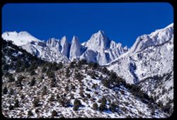
- Abstract:
- Whitney from Portal Station.
- Call Number:
- P06013
- Country:
- United States
- State/Province:
- California
- Physical Description:
- masked.
- Alternate Identifier:
- 1452.29
- Persistent URL:
- http://purl.dlib.indiana.edu/iudl/archives/cushman/P06013
-
- Description:
- 100 f 8
- Subject:
- Airports, Forests, Roads, Untersberg (Austria), Mountains, Shrubs, and Rock formations
- Series:
- 9-64
- Creator:
- Cushman, Charles W., 1896-1972
- Date Created:
- 1964-05-24
- Genre:
- Cityscape photographs and Views
- Frame Number:
- 14
- Abstract:
- On Untersberg Airport
- Call Number:
- P13254
- City:
- Salzburg
- Country:
- Austria
- State/Province:
- Salzburg
- Alternate Identifier:
- 964.14
- Persistent URL:
- http://purl.dlib.indiana.edu/iudl/archives/cushman/P13254
-
- Description:
- 100 f 6.3 tl
- Subject:
- Valleys, Black Mountains (Inyo County, Calif.), Death Valley (Calif. and Nev.), Mountains, Shrubs, and Hills
- Series:
- 8-55
- Creator:
- Cushman, Charles W., 1896-1972
- Date Created:
- 1955-03-22
- Genre:
- Landscape photographs
- Frame Number:
- 20
- Street Address:
- California State Highway 190
- County:
- Inyo
- Abstract:
- From 18 mi out - west toward Black Mtns - colored rock in valley
- Call Number:
- P07778
- Country:
- United States
- State/Province:
- California
- Alternate Identifier:
- 855.20
- Persistent URL:
- http://purl.dlib.indiana.edu/iudl/archives/cushman/P07778
-
- Description:
- 200 f 5 tl
- Subject:
- Valleys, Panamint Valley (Calif.), Panamint Range (Calif.), Shrubs, Trails & paths, Clouds, and Mountains
- Series:
- 3-55
- Creator:
- Cushman, Charles W., 1896-1972
- Date Created:
- 1955-02-27
- Genre:
- Landscape photographs
- Frame Number:
- 27
- Street Address:
- California State Highway 190
- Abstract:
- E across Panamint Valley from floor (Cal 190)
- Call Number:
- P07618
- Country:
- United States
- State/Province:
- California
- Alternate Identifier:
- 355.27
- Persistent URL:
- http://purl.dlib.indiana.edu/iudl/archives/cushman/P07618
-
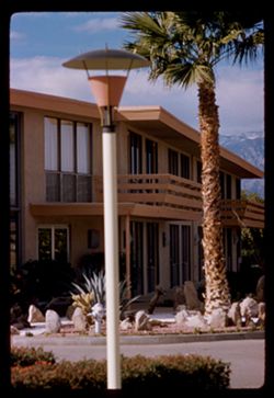
- Description:
- 100 f 6.3
- Subject:
- Indio Hacienda (Indio, Calif.), Balconies, Lampposts, Windows, Mountains, Public accommodation facilities, Shrubs, Rocks, Palms, and Doors & doorways
- Series:
- 24-61
- Creator:
- Cushman, Charles W., 1896-1972
- Date Created:
- 1961-01-01
- Genre:
- Architectural photographs
- Frame Number:
- 36
- County:
- Riverside
- Abstract:
- Indio Hacienda
- Call Number:
- P12602
- City:
- Indio
- Country:
- United States
- State/Province:
- California
- Alternate Identifier:
- 2461.36
- Persistent URL:
- http://purl.dlib.indiana.edu/iudl/archives/cushman/P12602
-
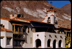
- Description:
- 100 f 8 tl
- Subject:
- Shutters, Balconies, Roofs, Flowers, Flowerpots, Death Valley (Calif. and Nev.), Windows, Scotty's Castle (Calif.), Mountains, Shrubs, Castles & pala...
- Series:
- 11-55
- Creator:
- Cushman, Charles W., 1896-1972
- Date Created:
- 1955-03-23
- Genre:
- Architectural photographs
- Frame Number:
- 31
- County:
- Inyo
- Abstract:
- the Castle
- Call Number:
- P07890
- Country:
- United States
- State/Province:
- California
- Alternate Identifier:
- 1155.31
- Persistent URL:
- http://purl.dlib.indiana.edu/iudl/archives/cushman/P07890
-

- Description:
- 25 f 11
- Subject:
- Hills, Mountains, Shrubs, Boulders, Rocks, Rock formations, and Crazy rocks
- Series:
- 14-52
- Creator:
- Cushman, Charles W., 1896-1972
- Date Created:
- 1952-04-08
- Genre:
- Landscape photographs
- Frame Number:
- 33
- Street Address:
- Mount Whitney Road
- County:
- Inyo
- Abstract:
- Crazy rocks along lower Mt. Whitney rd.
- Call Number:
- P06016
- City:
- Lone Pine
- Country:
- United States
- State/Province:
- California
- Alternate Identifier:
- 1452.33
- Persistent URL:
- http://purl.dlib.indiana.edu/iudl/archives/cushman/P06016
-
- Description:
- 100 f 5.6 sl 50 mm lens
- Subject:
- Lakes & ponds, Mountains, Dirt roads, Shrubs, Trees, and Shasta Lake (Calif.)
- Series:
- 17-55
- Creator:
- Cushman, Charles W., 1896-1972
- Date Created:
- 1955-06-16
- Genre:
- Landscape photographs
- Frame Number:
- 20
- Street Address:
- United States Highway 99
- County:
- Shasta
- Abstract:
- From same point
- Call Number:
- P08100
- City:
- Redding
- Country:
- United States
- State/Province:
- California
- Alternate Identifier:
- 1755.20
- Persistent URL:
- http://purl.dlib.indiana.edu/iudl/archives/cushman/P08100
-
- Description:
- 25 f 12
- Subject:
- National parks & reserves, Deserts, Saguaro, Mountains, Saguaro National Park (Ariz.), Cactus, and Shrubs
- Series:
- 3-52
- Creator:
- Cushman, Charles W., 1896-1972
- Date Created:
- 1952-01-15
- Genre:
- Identification photographs
- Frame Number:
- 4
- County:
- Pima
- Abstract:
- Multi branched Sahuaro showing nobbins.
- Call Number:
- P05573
- City:
- Tucson
- Country:
- United States
- State/Province:
- Arizona
- Alternate Identifier:
- 352.4
- Persistent URL:
- http://purl.dlib.indiana.edu/iudl/archives/cushman/P05573
-
- Description:
- 50 f 8
- Subject:
- Lakes & ponds, Bodies of water, Mountains, Shrubs, Trees, Coastlines, and Grant Lake (Calif.)
- Series:
- 11-54
- Creator:
- Cushman, Charles W., 1896-1972
- Date Created:
- 1954-09-16
- Genre:
- Landscape photographs
- Frame Number:
- 2
- County:
- Mono
- Abstract:
- Grant Lake.
- Call Number:
- P07371
- Country:
- United States
- State/Province:
- California
- Alternate Identifier:
- 1154.2
- Persistent URL:
- http://purl.dlib.indiana.edu/iudl/archives/cushman/P07371
-
- Description:
- 50 f 11
- Subject:
- Mountains, Shrubs, Rocks, Grasses, Chimney rocks, and Rock formations
- Series:
- 14-53
- Creator:
- Cushman, Charles W., 1896-1972
- Date Created:
- 1953-11-19
- Genre:
- Identification photographs and Landscape photographs
- Frame Number:
- 23
- Street Address:
- United States Highway 70 and United States Highway 60
- County:
- Pinal
- Abstract:
- Row of high chimney rocks above old road
- Call Number:
- P07019
- City:
- Superior
- Country:
- United States
- State/Province:
- Arizona
- Alternate Identifier:
- 1453.23
- Persistent URL:
- http://purl.dlib.indiana.edu/iudl/archives/cushman/P07019
-
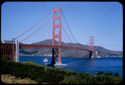
- Description:
- 50 f 8
- Subject:
- Sailboats, Bodies of water, Mountains, Shrubs, Electric lines, Trees, Golden Gate Bridge (San Francisco, Calif.), Suspension bridges, Utility poles, and Buil...
- Series:
- 2-53
- Creator:
- Cushman, Charles W., 1896-1972
- Date Created:
- 1953-02-08
- Genre:
- Architectural photographs
- Frame Number:
- 20
- County:
- San Francisco
- Abstract:
- GG bridge.
- Call Number:
- P06554
- City:
- San Francisco
- Country:
- United States
- State/Province:
- California
- Alternate Identifier:
- 253.20
- Persistent URL:
- http://purl.dlib.indiana.edu/iudl/archives/cushman/P06554
-
- Description:
- 100 f 9 tl
- Subject:
- Baboquivari Peak (Ariz.), Mountains, Shrubs, and Grasses
- Series:
- 6-59
- Creator:
- Cushman, Charles W., 1896-1972
- Date Created:
- 1959-01-28
- Genre:
- Landscape photographs
- Frame Number:
- 17
- County:
- Pima
- Abstract:
- Broadside view of Babo. range further north of PK.
- Call Number:
- P10555
- Country:
- United States
- State/Province:
- Arizona
- Alternate Identifier:
- 659.17
- Persistent URL:
- http://purl.dlib.indiana.edu/iudl/archives/cushman/P10555
-
- Description:
- 100 f 6.3 sl
- Subject:
- Roads, Mountains, Shrubs, Trees, and Shasta Dam (Calif.)
- Series:
- 17-55
- Creator:
- Cushman, Charles W., 1896-1972
- Date Created:
- 1955-06-16
- Genre:
- Landscape photographs
- Frame Number:
- 13
- County:
- Shasta
- Abstract:
- Mtns NW of dam
- Call Number:
- P08093
- Country:
- United States
- State/Province:
- California
- Alternate Identifier:
- 1755.13
- Persistent URL:
- http://purl.dlib.indiana.edu/iudl/archives/cushman/P08093
-
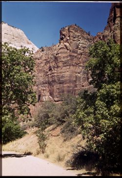
- Subject:
- Weeping Rock (Utah), Mountains, Trees, Temple of Sinawava (Utah), Zion Canyon (Utah), Zion National Park (Utah), Cliffs, Roads, National parks & reserves...
- Series:
- 11-40
- Creator:
- Cushman, Charles W., 1896-1972
- Date Created:
- 1940-07-11/1940-07-12
- Genre:
- Landscape photographs
- Frame Number:
- 2
- County:
- Washington
- Abstract:
- Bed of mountain stream below Weeping Rock.
- Call Number:
- P01962
- Country:
- United States
- State/Province:
- Utah
- Physical Description:
- Image was originally mounted in a glass enclosure. Before digitization, the image was removed and placed in a Wess Plastic, Inc. brand, 2" x 2", pl...
- Alternate Identifier:
- 1140.2
- Persistent URL:
- http://purl.dlib.indiana.edu/iudl/archives/cushman/P01962
-
- Description:
- 50 f 8 Haze F
- Subject:
- Valleys, Rocks, Bishop Peak (Calif.), Mountains, Trees, Owens Valley (Calif.), Shadows, Shrubs, and Roads
- Series:
- 11-54
- Creator:
- Cushman, Charles W., 1896-1972
- Date Created:
- 1954-09-16
- Genre:
- Landscape photographs
- Frame Number:
- 4
- Street Address:
- United States Highway 395, United States Highway 6/395, and California State Highway 14
- County:
- Inyo
- Abstract:
- View south toward Owens valley where Bishop lies.
- Call Number:
- P07373
- Country:
- United States
- State/Province:
- California
- Alternate Identifier:
- 1154.4
- Persistent URL:
- http://purl.dlib.indiana.edu/iudl/archives/cushman/P07373
-
- Description:
- 50 f 8
- Subject:
- Mountains, Cascade Range, Lassen Volcanic National Park (Calif.), Lava domes, Bumpass Mountain (Calif.), Volcanoes, Shrubs, Clouds, Volcanic domes, and Trees
- Series:
- 6-54
- Creator:
- Cushman, Charles W., 1896-1972
- Date Created:
- 1954-08-19
- Genre:
- Landscape photographs
- Frame Number:
- 4
- County:
- Shasta
- Abstract:
- Bumpass
- Call Number:
- P07223
- Country:
- United States
- State/Province:
- California
- Alternate Identifier:
- 654.4
- Persistent URL:
- http://purl.dlib.indiana.edu/iudl/archives/cushman/P07223
-
- Description:
- 100 f 5.6 tl
- Subject:
- Mountains, Trees, and Shrubs
- Series:
- 17-55
- Creator:
- Cushman, Charles W., 1896-1972
- Date Created:
- 1955-06-16
- Frame Number:
- 3
- County:
- Trinity and Shasta
- Abstract:
- Tree dotted mtn slope in Shasta County [65568 mi]
- Call Number:
- P08085
- City:
- Weaverville
- Country:
- United States
- State/Province:
- California
- Alternate Identifier:
- 1755.3
- Persistent URL:
- http://purl.dlib.indiana.edu/iudl/archives/cushman/P08085
-
- Description:
- 100 f 6.3 tel. Lens
- Subject:
- Diablo, Mount (Calif.), Vessels, Streets, Hills, Bodies of water, Mountains, Dwellings, Trees, Buildings, Twin Peaks (San Francisco County, Calif.), Automobi...
- Series:
- 19-55
- Creator:
- Cushman, Charles W., 1896-1972
- Date Created:
- 1955-07-02
- Genre:
- Cityscape photographs
- Frame Number:
- 1
- County:
- San Francisco
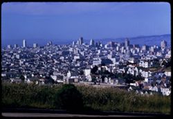
- Abstract:
- Mt. Diablo from Twin Peaks
- Call Number:
- P08154
- City:
- San Francisco
- Country:
- United States
- State/Province:
- California
- Physical Description:
- Image was originally mounted in a glass enclosure. Before digitization, the image was removed and placed in a Wess Plastic, Inc. brand, 2" x 2", pl...
- Alternate Identifier:
- 1955.1
- Persistent URL:
- http://purl.dlib.indiana.edu/iudl/archives/cushman/P08154
-
- Description:
- 25 f 9
- Subject:
- Buildings, Cities & towns, Mountains, Trees, Dwellings, Hotels, Streets, Copper Queen Hotel (Bisbee, Ariz.), Automobiles, Shrubs, Churches, Flagpoles, an...
- Series:
- 1-52
- Creator:
- Cushman, Charles W., 1896-1972
- Date Created:
- 1952-01-04
- Genre:
- Views and Cityscape photographs
- Frame Number:
- 30
- County:
- Cochise
- Abstract:
- from higher up. [Bisbee + Mtn from Main st.]
- Call Number:
- P05520
- City:
- Bisbee
- Country:
- United States
- State/Province:
- Arizona
- Alternate Identifier:
- 152.30
- Persistent URL:
- http://purl.dlib.indiana.edu/iudl/archives/cushman/P05520
-
- Description:
- 50 f 8
- Subject:
- Bishop Creek (Inyo County, Calif.), Flowers, Donkeys, Animals, Mountains, Shrubs, Trees, Sagebrush, and Rocks
- Series:
- 11-54
- Creator:
- Cushman, Charles W., 1896-1972
- Date Created:
- 1954-09-17
- Genre:
- Identification photographs
- Frame Number:
- 18
- County:
- Inyo
- Abstract:
- Jennie in the sage brush.
- Call Number:
- P07387
- City:
- Bishop
- Country:
- United States
- State/Province:
- California
- Alternate Identifier:
- 1154.18
- Persistent URL:
- http://purl.dlib.indiana.edu/iudl/archives/cushman/P07387
-
- Description:
- 100 f 6 tl
- Subject:
- Rocks, Mountains, Trees, Canyons, Feather River (Calif.), Shrubs, and Utility poles
- Series:
- 18-55
- Creator:
- Cushman, Charles W., 1896-1972
- Date Created:
- 1955-06-19
- Genre:
- Landscape photographs
- Frame Number:
- 21
- County:
- Plumas
- Abstract:
- View downstream
- Call Number:
- P08137
- Country:
- United States
- State/Province:
- California
- Alternate Identifier:
- 1855.21
- Persistent URL:
- http://purl.dlib.indiana.edu/iudl/archives/cushman/P08137
-
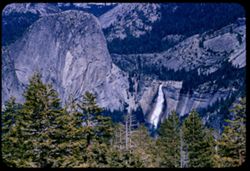
- Description:
- 100 f 8 tl
- Subject:
- Waterfalls, Yosemite National Park (Calif.), Mountains, Trees, Half Dome (Calif.), Nevada Fall (Calif.), and Shrubs
- Series:
- 20-55
- Creator:
- Cushman, Charles W., 1896-1972
- Date Created:
- 1955-07-07
- Genre:
- Landscape photographs
- Frame Number:
- 24
- County:
- Mariposa
- Abstract:
- Nevada Fall
- Call Number:
- P08207
- Country:
- United States
- State/Province:
- California
- Alternate Identifier:
- 2055.24
- Persistent URL:
- http://purl.dlib.indiana.edu/iudl/archives/cushman/P08207
-
- Description:
- 50 f 8
- Subject:
- Valleys, Hills, Mountains, Lost Mine Trail (Big Bend National Park (Tex.)), Trees, Canyons, National parks & reserves, Big Bend National Park (Tex.), Cli...
- Series:
- 16-51
- Creator:
- Cushman, Charles W., 1896-1972
- Date Created:
- 1951-12-27
- Genre:
- Landscape photographs
- Frame Number:
- 11
- County:
- Brewster
- Abstract:
- Road winds down to The Basin
- Call Number:
- P05430
- Country:
- United States
- State/Province:
- Texas
- Alternate Identifier:
- 1651.11
- Persistent URL:
- http://purl.dlib.indiana.edu/iudl/archives/cushman/P05430
-
- Description:
- 50 f 9
- Subject:
- Passes (Landforms), Rocks, Mountains, Tioga Pass (Calif.), Yosemite Creek (Calif.), Dana Plateau (Calif.), Volcanoes, Shrubs, and Flowers
- Series:
- 9-54
- Creator:
- Cushman, Charles W., 1896-1972
- Date Created:
- 1954-09-16
- Genre:
- Landscape photographs
- Frame Number:
- 36
- County:
- Mono
- Abstract:
- Combs above south wall of Tioga Pass from N.
- Call Number:
- P07345
- Country:
- United States
- State/Province:
- California
- Alternate Identifier:
- 954.36
- Persistent URL:
- http://purl.dlib.indiana.edu/iudl/archives/cushman/P07345
-
- Description:
- 25 f 9
- Subject:
- Buildings, Cities & towns, Mountains, Telegraph Hill (San Francisco, Calif.), Suspension bridges, Bays (Bodies of water), Golden Gate Bridge (San Francis...
- Series:
- 10-52
- Creator:
- Cushman, Charles W., 1896-1972
- Date Created:
- 1952-03-12
- Genre:
- Views and Cityscape photographs
- Frame Number:
- 11
- County:
- San Francisco
- Abstract:
- Golden Gate from Telegraph Hill
- Call Number:
- P05846
- City:
- San Francisco
- Country:
- United States
- State/Province:
- California
- Alternate Identifier:
- 1052.11
- Persistent URL:
- http://purl.dlib.indiana.edu/iudl/archives/cushman/P05846
-
- Description:
- 100 f 5.6 tl
- Subject:
- Valleys, Facilities, Hills, Mountains, Storage tanks, Oil wells, Temblor Range (Calif.), Electric lines, Shrubs, Roads, and Utility poles
- Series:
- 4-55
- Creator:
- Cushman, Charles W., 1896-1972
- Date Created:
- 1955-03-01
- Genre:
- Views
- Frame Number:
- 23
- County:
- Kern
- Abstract:
- View west from Fellows
- Call Number:
- P07650
- City:
- Fellows
- Country:
- United States
- State/Province:
- California
- Alternate Identifier:
- 455.23
- Persistent URL:
- http://purl.dlib.indiana.edu/iudl/archives/cushman/P07650
-
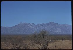
- Description:
- 50 f 11
- Subject:
- Mountains, Deserts, Shrubs, and Boundary Peak (Nev.)
- Series:
- 12-54
- Creator:
- Cushman, Charles W., 1896-1972
- Date Created:
- 1954-09-17
- Genre:
- Landscape photographs
- Frame Number:
- 4
- Street Address:
- United States Highway 6
- County:
- Esmeralda
- Abstract:
- Boundary Line Peak from north, just inside Nevada.
- Call Number:
- P07394
- Country:
- United States
- State/Province:
- Nevada
- Physical Description:
- Image was originally mounted in a glass enclosure. Before digitization, the image was removed and placed in a Wess Plastic, Inc. brand, 2" x 2", pl...
- Alternate Identifier:
- 1254.4
- Persistent URL:
- http://purl.dlib.indiana.edu/iudl/archives/cushman/P07394
-
- Description:
- 50 f 11
- Subject:
- Dirt, Mountains, Shrubs, Trees, Rocks, Rock slopes, and Grasses
- Series:
- 8-53
- Creator:
- Cushman, Charles W., 1896-1972
- Date Created:
- 1953-10-09
- Genre:
- Landscape photographs
- Frame Number:
- 33
- Street Address:
- United States Highway 50
- County:
- Carson City
- Abstract:
- Mtns along US 50 down bound to Carson City.
- Call Number:
- P06795
- City:
- Carson City
- Country:
- United States
- State/Province:
- Nevada
- Alternate Identifier:
- 853.33
- Persistent URL:
- http://purl.dlib.indiana.edu/iudl/archives/cushman/P06795
-
- Description:
- 100 f 6.3 tl
- Subject:
- Fences, Mountains, Trees, Dwellings, Horses, Electric lines, Shrubs, and Cochise Head (Ariz.)
- Series:
- 5-59
- Creator:
- Cushman, Charles W., 1896-1972
- Date Created:
- 1959-01-23
- Genre:
- Landscape photographs
- Frame Number:
- 36
- Street Address:
- Arizona State Highway 86
- County:
- Cochise
- Abstract:
- Cochise Head from Ariz Hwy 86
- Call Number:
- P10537
- Country:
- United States
- State/Province:
- Arizona
- Alternate Identifier:
- 559.36
- Persistent URL:
- http://purl.dlib.indiana.edu/iudl/archives/cushman/P10537
-
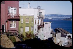
- Description:
- 50 f 8
- Subject:
- Fire escapes, Bodies of water, Mountains, Marine terminals, Telegraph Hill (San Francisco, Calif.), Dwellings, Shadows, Streets, Sidewalks, Shrubs, and Piers...
- Series:
- 2-53
- Creator:
- Cushman, Charles W., 1896-1972
- Date Created:
- 1953-02-09
- Genre:
- Cityscape photographs
- Frame Number:
- 25
- Street Address:
- Union Street and Montgomery Street
- County:
- San Francisco
- Abstract:
- Union St. - east of Montgomery.
- Call Number:
- P06559
- City:
- San Francisco
- Country:
- United States
- State/Province:
- California
- Alternate Identifier:
- 253.25
- Persistent URL:
- http://purl.dlib.indiana.edu/iudl/archives/cushman/P06559
-
- Description:
- 50 f 5.6
- Subject:
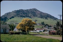
- Buildings, Hills, Mountains, Grasses, Trees, Utility poles, Acacia, Houses, Flowers, Roads, Automobiles, Electric lines, and Shrubs
- Series:
- 8-52
- Creator:
- Cushman, Charles W., 1896-1972
- Date Created:
- 1952-03-02
- Genre:
- Landscape photographs
- Frame Number:
- 37
- County:
- San Luis Obispo
- Abstract:
- San Luis mtn with acacia below
- Call Number:
- P05796
- City:
- San Luis Obispo
- Country:
- United States
- State/Province:
- California
- Alternate Identifier:
- 852.37
- Persistent URL:
- http://purl.dlib.indiana.edu/iudl/archives/cushman/P05796
-
- Description:
- 50 f 8.8
- Subject:
- Yosemite National Park (Calif.), Tioga Peak (Calif.), Mountains, Trees, Streams, Shrubs, Roads, Rocks, and Tioga Pass (Calif.)
- Series:
- 10-54
- Creator:
- Cushman, Charles W., 1896-1972
- Date Created:
- 1954-09-16
- Genre:
- Landscape photographs
- Frame Number:
- 9
- County:
- Mono
- Abstract:
- Great red brown mtn next to Tioga Pk.
- Call Number:
- P07356
- Country:
- United States
- State/Province:
- California
- Physical Description:
- Anscochrome film.
- Alternate Identifier:
- 1054.9
- Persistent URL:
- http://purl.dlib.indiana.edu/iudl/archives/cushman/P07356
-
- Subject:
- National parks & reserves, Zion National Park (Utah), Temple of Sinawava (Utah), Cliffs, Mountains, Shrubs, Trees, and Clouds
- Series:
- 11-40
- Creator:
- Cushman, Charles W., 1896-1972
- Date Created:
- 1940-07-11/1940-07-12
- Genre:
- Landscape photographs
- Frame Number:
- 8
- County:
- Washington
- Abstract:
- Temple of Sinawara.
- Call Number:
- P01968
- Country:
- United States
- State/Province:
- Utah
- Physical Description:
- Image was originally mounted in a glass enclosure. Before digitization, the image was removed and placed in a Wess Plastic, Inc. brand, 2" x 2", pl...
- Alternate Identifier:
- 1140.8
- Persistent URL:
- http://purl.dlib.indiana.edu/iudl/archives/cushman/P01968
-
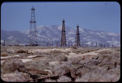
- Description:
- 100 f 5.6 tl
- Subject:
- Oil wells, Storage tanks, Hills, Mountains, Dirt roads, Shrubs, Oil well drilling rigs, and Facilities
- Series:
- 4-55
- Creator:
- Cushman, Charles W., 1896-1972
- Date Created:
- 1955-03-01
- Genre:
- Views
- Frame Number:
- 22
- County:
- Kern
- Abstract:
- 3 derricks with folded hills in background (Hazy)
- Call Number:
- P07649
- City:
- Taft
- Country:
- United States
- State/Province:
- California
- Alternate Identifier:
- 455.22
- Persistent URL:
- http://purl.dlib.indiana.edu/iudl/archives/cushman/P07649
-
- Description:
- 100 f 8
- Subject:
- Rock formations, Hills, Mountains, Untersberg (Austria), Shrubs, Roads, Airports, and Cliffs
- Series:
- 9-64
- Creator:
- Cushman, Charles W., 1896-1972
- Date Created:
- 1964-05-24
- Genre:
- Landscape photographs
- Frame Number:
- 17
- Abstract:
- On Untersberg Toward Salzburg
- Call Number:
- P13257
- City:
- Salzburg
- Country:
- Austria
- State/Province:
- Salzburg
- Alternate Identifier:
- 964.17
- Persistent URL:
- http://purl.dlib.indiana.edu/iudl/archives/cushman/P13257
-
- Description:
- 50 f 11 HF
- Subject:
- Valleys, Inyo Mountains (Calif.), Mountains, Owens Valley (Calif.), Deserts, Shrubs, Roads, and Rocks
- Series:
- 12-54
- Creator:
- Cushman, Charles W., 1896-1972
- Date Created:
- 1954-09-18
- Genre:
- Landscape photographs
- Frame Number:
- 27
- Street Address:
- Mt. Whitney Road
- County:
- Inyo
- Abstract:
- Switch-back coming down Mt Whitney rd.
- Call Number:
- P07417
- Country:
- United States
- State/Province:
- California
- Alternate Identifier:
- 1254.27
- Persistent URL:
- http://purl.dlib.indiana.edu/iudl/archives/cushman/P07417
-
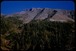
- Description:
- 25 f 8 Pola
- Subject:
- Scenic overlooks, Trees, National parks & reserves, Snow, Cliffs, Roads, Sequoia National Park (Calif.), Sierra Nevada (Calif. and Nev.), Mountains, and ...
- Series:
- 14-52
- Creator:
- Cushman, Charles W., 1896-1972
- Date Created:
- 1952-04-06
- Genre:
- Landscape photographs
- Frame Number:
- 1
- Street Address:
- California State Highway 198
- County:
- Tulare
- Abstract:
- High ridge from turnout on road down.
- Call Number:
- P05985
- Country:
- United States
- State/Province:
- California
- Alternate Identifier:
- 1452.1
- Persistent URL:
- http://purl.dlib.indiana.edu/iudl/archives/cushman/P05985
-
- Description:
- 100 f 6.3 TL
- Subject:
- San Gorgonio Mountain (Calif.), Mountains, Utility poles, Palms, Shrubs, Roads, and Dwellings
- Series:
- 24-61
- Creator:
- Cushman, Charles W., 1896-1972
- Date Created:
- 1961-12-25
- Genre:
- Landscape photographs
- Frame Number:
- 2
- County:
- San Bernardino
- Abstract:
- Mr San Gorgonio and Mt. San Gorgonio
- Call Number:
- P12568
- City:
- Palm Desert
- Country:
- United States
- State/Province:
- California
- Alternate Identifier:
- 2461.2
- Persistent URL:
- http://purl.dlib.indiana.edu/iudl/archives/cushman/P12568
-
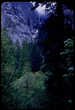
- Description:
- 50 f 4
- Subject:
- Illilouette Fall (Calif.), National parks & reserves, Mountains, Yosemite National Park (Calif.), Waterfalls, Trees, Yosemite Valley (Calif.), Vernal Fal...
- Series:
- 6-53
- Creator:
- Cushman, Charles W., 1896-1972
- Date Created:
- 1953-05-15
- Genre:
- Landscape photographs
- Frame Number:
- 18
- County:
- Mariposa
- Abstract:
- Illilouette Fall from Vernal fall trail
- Call Number:
- P06705
- Country:
- United States
- State/Province:
- California
- Alternate Identifier:
- 653.18
- Persistent URL:
- http://purl.dlib.indiana.edu/iudl/archives/cushman/P06705
-
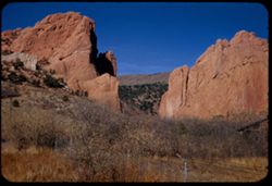
- Description:
- 25 f 11+
- Subject:
- Rock formations, Fences, Garden of the Gods (Colorado Springs, Colo.), Mountains, Grasses, Trees, Barbed wire, Shrubs, and Buttes
- Series:
- 21-52
- Creator:
- Cushman, Charles W., 1896-1972
- Date Created:
- 1952-10-27
- Genre:
- Landscape photographs
- Frame Number:
- 16
- County:
- El Paso
- Abstract:
- Gateway Garden to Gods
- Call Number:
- P06247
- City:
- Colorado Springs
- Country:
- United States
- State/Province:
- Colorado
- Alternate Identifier:
- 2152.16
- Persistent URL:
- http://purl.dlib.indiana.edu/iudl/archives/cushman/P06247
-
- Description:
- 50 f 9
- Subject:
- Passes (Landforms), Mountains, Shrubs, Trees, Buttes, and Sonora Pass (Calif.)
- Series:
- 9-54
- Creator:
- Cushman, Charles W., 1896-1972
- Date Created:
- 1954-09-15
- Genre:
- Landscape photographs
- Frame Number:
- 10
- County:
- Tuolumne
- Abstract:
- Cone above Sonora Pass - to south.
- Call Number:
- P07321
- Country:
- United States
- State/Province:
- California
- Alternate Identifier:
- 954.10
- Persistent URL:
- http://purl.dlib.indiana.edu/iudl/archives/cushman/P07321
-
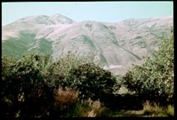
- Subject:
- Mountains, Dirt roads, Shrubs, Apple trees, Grasses, and Apple orchards
- Series:
- 4-38
- Creator:
- Cushman, Charles W., 1896-1972
- Date Created:
- 1938-09-21
- Genre:
- Landscape photographs
- Frame Number:
- 40
- County:
- Yakima
- Abstract:
- D-40= Mtns behind apple orchard
- Call Number:
- P01469
- City:
- Yakima
- Country:
- United States
- State/Province:
- Washington
- Physical Description:
- Color corrected: magenta cast [fading of yellow dye]. Image was originally mounted in a glass enclosure. Before digitization, the image was removed and place...
- Alternate Identifier:
- 438.40
- Persistent URL:
- http://purl.dlib.indiana.edu/iudl/archives/cushman/P01469
-
- Description:
- 100 f 11
- Subject:
- Hills, Roads, Cliffs, Mountains, Shrubs, Trees, and Grasses
- Series:
- 5-62
- Creator:
- Cushman, Charles W., 1896-1972
- Date Created:
- 1962-10-05
- Genre:
- Landscape photographs
- Frame Number:
- 16
- County:
- Coconino
- Abstract:
- East from 6 or 7 mi. west of Sedona
- Call Number:
- P12783
- City:
- Sedona
- Country:
- United States
- State/Province:
- Arizona
- Alternate Identifier:
- 562.16
- Persistent URL:
- http://purl.dlib.indiana.edu/iudl/archives/cushman/P12783
-
- Subject:
- Blue Ridge Mountains, Shrubs, Trees, Wildflowers, and Mountains
- Series:
- 18-40
- Creator:
- Cushman, Charles W., 1896-1972
- Date Created:
- 1940-10-11
- Genre:
- Landscape photographs
- Frame Number:
- 13
- Street Address:
- Skyline Drive
- Abstract:
- East side of Blue Ridge Mtns. from Skyline Drive.
- Call Number:
- P02099
- Country:
- United States
- State/Province:
- Virginia
- Physical Description:
- Image was originally mounted in a glass enclosure. Before digitization, the image was removed and placed in a Wess Plastic, Inc. brand, 2" x 2", pl...
- Alternate Identifier:
- 1840.13
- Persistent URL:
- http://purl.dlib.indiana.edu/iudl/archives/cushman/P02099
-
- Description:
- 50 f 5.6 Pola
- Subject:
- Pink brush, Roads, Mountains, Shrubs, Trees, Grasses, and Clouds
- Series:
- 9-53
- Creator:
- Cushman, Charles W., 1896-1972
- Date Created:
- 1953-10-11
- Genre:
- Landscape photographs
- Frame Number:
- 15
- Street Address:
- United States Highway 50
- County:
- Utah
- Abstract:
- From US 50 6 mi w of Thistle.
- Call Number:
- P06816
- City:
- Thistle
- Country:
- United States
- State/Province:
- Utah
- Physical Description:
- masked.
- Alternate Identifier:
- 953.15
- Persistent URL:
- http://purl.dlib.indiana.edu/iudl/archives/cushman/P06816
-
- Subject:
- Reflections, Mountains, Shrubs, Trees, Shenandoah River (Va. and W. Va.), and Rivers
- Series:
- 16-40
- Creator:
- Cushman, Charles W., 1896-1972
- Date Created:
- 1940-09-16/1940-09-23
- Genre:
- Landscape photographs
- Frame Number:
- 7
- County:
- Jefferson
- Abstract:
- Shenandoah river, in W. Va., in mid-September.
- Call Number:
- P02056
- City:
- Charles Town
- Country:
- United States
- State/Province:
- West Virginia
- Physical Description:
- Image was originally mounted in a glass enclosure. Before digitization, the image was removed and placed in a Wess Plastic, Inc. brand, 2" x 2", pl...
- Alternate Identifier:
- 1640.7
- Persistent URL:
- http://purl.dlib.indiana.edu/iudl/archives/cushman/P02056
-
- Description:
- 25 f 11
- Subject:
- Pikes Peak (Colo.), Cliffs, Mountains, Shrubs, Buttes, Rock formations, and Garden of the Gods (Colorado Springs, Colo.)
- Series:
- 22-52
- Creator:
- Cushman, Charles W., 1896-1972
- Date Created:
- 1952-10-27
- Genre:
- Landscape photographs
- Frame Number:
- 1
- County:
- El Paso
- Abstract:
- Pike's Peak through gateway of Garden of Gods
- Call Number:
- P06255
- City:
- Colorado Springs
- Country:
- United States
- State/Province:
- Colorado
- Alternate Identifier:
- 2252.1
- Persistent URL:
- http://purl.dlib.indiana.edu/iudl/archives/cushman/P06255
-
- Description:
- 50 f 11 sl
- Subject:
- Deserts, Mountains, Shrubs, Cactus, and Saguaro National Park (Ariz.)
- Series:
- 10-59
- Creator:
- Cushman, Charles W., 1896-1972
- Date Created:
- 1959-03-03
- Genre:
- Identification photographs
- Frame Number:
- 5
- County:
- Pima
- Abstract:
- Multi-branched Giant Sohuaro
- Call Number:
- P10693
- City:
- Tucson
- Country:
- United States
- State/Province:
- Arizona
- Alternate Identifier:
- 1059.5
- Persistent URL:
- http://purl.dlib.indiana.edu/iudl/archives/cushman/P10693
-
- Subject:
- Deserts, Flowers, Saguaro, Ocotillo, Mountains, Shrubs, Cactus, and Clouds
- Series:
- 4-40
- Creator:
- Cushman, Charles W., 1896-1972
- Date Created:
- 1940-04-01
- Genre:
- Identification photographs
- Frame Number:
- 18
- County:
- Pima
- Abstract:
- Desert blooms: Flaming Ocotillo: Giant Sahuaras
- Call Number:
- P01805
- Country:
- United States
- State/Province:
- Arizona
- Physical Description:
- Image was originally mounted in a glass enclosure. Before digitization, the image was removed and placed in a Wess Plastic, Inc. brand, 2" x 2", pl...
- Alternate Identifier:
- 440.18
- Persistent URL:
- http://purl.dlib.indiana.edu/iudl/archives/cushman/P01805
-
- Description:
- 100 f 6.3 tl
- Subject:
- Channels, Brawley Wash (Ariz.), Roads, Mountains, Shrubs, Electric lines, and Bulls
- Series:
- 6-59
- Creator:
- Cushman, Charles W., 1896-1972
- Date Created:
- 1959-01-28
- Genre:
- Identification photographs
- Frame Number:
- 18
- Street Address:
- Sasabe Road
- County:
- Pima
- Abstract:
- 2 Brahma bulls on Sasabe road
- Call Number:
- P10556
- Country:
- United States
- State/Province:
- Arizona
- Alternate Identifier:
- 659.18
- Persistent URL:
- http://purl.dlib.indiana.edu/iudl/archives/cushman/P10556
-
- Description:
- 100 f 6.3 tl
- Subject:
- Channels, Brawley Wash (Ariz.), Roads, Mountains, Shrubs, Electric lines, and Bulls
- Series:
- 6-59
- Creator:
- Cushman, Charles W., 1896-1972
- Date Created:
- 1959-01-28
- Genre:
- Identification photographs
- Frame Number:
- 19
- Street Address:
- Sasabe Road
- County:
- Pima
- Abstract:
- One B B
- Call Number:
- P10557
- Country:
- United States
- State/Province:
- Arizona
- Alternate Identifier:
- 659.19
- Persistent URL:
- http://purl.dlib.indiana.edu/iudl/archives/cushman/P10557
-
- Subject:
- San Francisco Peaks (Ariz.), Hills, Automobiles, Roads, Bridges, Mountains, Grand Canyon Junction (Ariz.), Shrubs, Snow, Trees, Rocks, Fences, and Masonry
- Series:
- 10-39
- Creator:
- Cushman, Charles W., 1896-1972
- Date Created:
- 1939-12-01
- Genre:
- Landscape photographs
- Frame Number:
- 3
- County:
- Coconino
- Abstract:
- T-3: San Franciscos Pk. from Grand Canyon Junction
- Call Number:
- P01719
- City:
- Flagstaff
- Country:
- United States
- State/Province:
- Arizona
- Physical Description:
- some dye fading. Image was originally mounted in a glass enclosure. Before digitization, the image was removed and placed in a Wess Plastic, Inc. brand, 2&qu...
- Alternate Identifier:
- 1039.3
- Persistent URL:
- http://purl.dlib.indiana.edu/iudl/archives/cushman/P01719
-
- Description:
- 25 f 9
- Subject:
- Plains, Hills, Mountains, Shrubs, Sawtooth Mountain (Tex.), and Davis Mountains State Park (Tex.)
- Series:
- 17-51
- Creator:
- Cushman, Charles W., 1896-1972
- Date Created:
- 1951-12-29
- Genre:
- Landscape photographs
- Frame Number:
- 5
- Street Address:
- Texas State Highway 166 and Loop Texas State Highway 166
- County:
- Jeff Davis
- Abstract:
- Sawtooth Mtn. from SW.
- Call Number:
- P05462
- Country:
- United States
- State/Province:
- Texas
- Alternate Identifier:
- 1751.5
- Persistent URL:
- http://purl.dlib.indiana.edu/iudl/archives/cushman/P05462
-
- Description:
- 25 f 13
- Subject:
- Sabino Canyon (Ariz.), Canyons, Saguaro, Cliffs, Mountains, Shrubs, Cactus, Rocks, Rock formations, and Santa Catalina Mountains (Ariz.)
- Series:
- 5-52
- Creator:
- Cushman, Charles W., 1896-1972
- Date Created:
- 1952-02-05
- Genre:
- Landscape photographs
- Frame Number:
- 26
- County:
- Pima
- Abstract:
- Up wall of Sabino Canyon in morning
- Call Number:
- P05671
- Country:
- United States
- State/Province:
- Arizona
- Alternate Identifier:
- 552.26
- Persistent URL:
- http://purl.dlib.indiana.edu/iudl/archives/cushman/P05671
-
- Subject:
- Deserts, Roskruge Mountains (Ariz.), Mountains, Shrubs, Cactus, and Clouds
- Series:
- 5-40
- Creator:
- Cushman, Charles W., 1896-1972
- Date Created:
- 1940-05-01
- Genre:
- Landscape photographs
- Frame Number:
- 17
- County:
- Pima
- Abstract:
- An Arizona desert . Roskruge Mtns. In distance. View is northeast.
- Call Number:
- P01835
- Country:
- United States
- State/Province:
- Arizona
- Physical Description:
- Image was originally mounted in a glass enclosure. Before digitization, the image was removed and placed in a Wess Plastic, Inc. brand, 2" x 2", pl...
- Alternate Identifier:
- 540.17
- Persistent URL:
- http://purl.dlib.indiana.edu/iudl/archives/cushman/P01835
-

- Subject:
- Lakes & ponds, White Mountains (N.H. and Me.), Mount Willey (N.H.), Mountains, Shrubs, and Trees
- Series:
- 16-41
- Creator:
- Cushman, Charles W., 1896-1972
- Date Created:
- 1941-09-15
- Genre:
- Landscape photographs
- Frame Number:
- 18
- Abstract:
- White Mtns., across a lake at foot of Mt. Willey
- Call Number:
- P02439
- Country:
- United States
- State/Province:
- New Hampshire
- Physical Description:
- Image was originally mounted in a glass enclosure. Before digitization, the image was removed and placed in a Wess Plastic, Inc. brand, 2" x 2", pl...
- Alternate Identifier:
- 1641.18
- Persistent URL:
- http://purl.dlib.indiana.edu/iudl/archives/cushman/P02439
-
- Description:
- 100 f 6.3 tl
- Subject:
- Hills, Bodies of water, Mountains, Shrubs, Snow, Trees, Clouds, Fences, Shasta, Mount (Calif. : Mountain), and Grasses
- Series:
- 18-55
- Creator:
- Cushman, Charles W., 1896-1972
- Date Created:
- 1955-06-17
- Genre:
- Landscape photographs
- Frame Number:
- 2
- County:
- Siskiyou
- Abstract:
- Mt. Shasta at 2:35 from road east of Grenada
- Call Number:
- P08119
- City:
- Grenada
- Country:
- United States
- State/Province:
- California
- Alternate Identifier:
- 1855.2
- Persistent URL:
- http://purl.dlib.indiana.edu/iudl/archives/cushman/P08119
-
- Description:
- 25 f 11
- Subject:
- California poppies, Flowers, Streets, Mountains, Shrubs, Trees, Rocks, La Cumbre Peak (Calif.), Buildings, and Figurines
- Series:
- 8-52
- Creator:
- Cushman, Charles W., 1896-1972
- Date Created:
- 1952-02-28
- Genre:
- Cityscape photographs
- Frame Number:
- 14
- Street Address:
- Kenwood Road
- County:
- Santa Barbara
- Abstract:
- View across Sta Barbara to LaCumbre, Montecito, & other mtns from top of Kenwood Rd.
- Call Number:
- P05773
- City:
- Santa Barbara and Montecito
- Country:
- United States
- State/Province:
- California
- Alternate Identifier:
- 852.14
- Persistent URL:
- http://purl.dlib.indiana.edu/iudl/archives/cushman/P05773
-
- Description:
- 100 f 9 TL
- Subject:
- Passes (Landforms), Cajon Pass (Calif.), Shrubs, Rock formations, Mountains, and Grasses
- Series:
- 3-69
- Creator:
- Cushman, Charles W., 1896-1972
- Date Created:
- 1969-03-20
- Genre:
- Landscape photographs
- Frame Number:
- 15
- County:
- San Bernardino
- Abstract:
- In Cajon Pass
- Call Number:
- P15767
- Country:
- United States
- State/Province:
- California
- Alternate Identifier:
- 369.15
- Persistent URL:
- http://purl.dlib.indiana.edu/iudl/archives/cushman/P15767
-
- Description:
- 100 f 9 TL
- Subject:
- Passes (Landforms), Hills, Cajon Pass (Calif.), Shrubs, Trees, Rock formations, Mountains, and Grasses
- Series:
- 2-69
- Creator:
- Cushman, Charles W., 1896-1972
- Date Created:
- 1969-03-14
- Genre:
- Landscape photographs
- Frame Number:
- 17
- County:
- San Bernardino
- Abstract:
- Cajon Pass
- Call Number:
- P15734
- Country:
- United States
- State/Province:
- California
- Alternate Identifier:
- 269.17
- Persistent URL:
- http://purl.dlib.indiana.edu/iudl/archives/cushman/P15734
-
- Description:
- 50 f 9
- Subject:
- National parks & reserves, Deserts, Devils Garden (Grand County, Utah), Hills, Sand, Mountains, Shrubs, Arches National Park (Utah), Wildflowers, Rock fo...
- Series:
- 27-52
- Creator:
- Cushman, Charles W., 1896-1972
- Date Created:
- 1952-11-04
- Genre:
- Landscape photographs
- Frame Number:
- 21
- County:
- Grand
- Abstract:
- En route to Devil's Garden. Sandstone Dunes.
- Call Number:
- P06466
- Country:
- United States
- State/Province:
- Utah
- Alternate Identifier:
- 2752.21
- Persistent URL:
- http://purl.dlib.indiana.edu/iudl/archives/cushman/P06466
-
- Description:
- 100 f 6.3 SL
- Subject:
- Mountains, Shrubs, Rock formations, Malheur River (Or.), and Clouds
- Series:
- 11-58
- Creator:
- Cushman, Charles W., 1896-1972
- Date Created:
- 1958-06-14
- Genre:
- Landscape photographs
- Frame Number:
- 11
- County:
- Malheur
- Abstract:
- Tip of nearby
- Call Number:
- P09986
- Country:
- United States
- State/Province:
- Oregon
- Alternate Identifier:
- 1158.11
- Persistent URL:
- http://purl.dlib.indiana.edu/iudl/archives/cushman/P09986
-

- Subject:
- Hotels, Balconies, Streets, Hills, Automobiles, Windows, Hotel Martinez (Cannes, France), Sidewalks, Shrubs, Trees, Buildings, Palms, and Mountains
- Series:
- 7-60
- Creator:
- Cushman, Charles W., 1896-1972
- Date Created:
- 1960-05-15
- Genre:
- Cityscape photographs
- Frame Number:
- 27
- County:
- Alpes-Maritimes
- Abstract:
- View north alongside hotel Martinez
- Call Number:
- P11091
- City:
- Cannes
- Country:
- France
- State/Province:
- Provence-Alpes-Côte d'Azur
- Alternate Identifier:
- 760.27
- Persistent URL:
- http://purl.dlib.indiana.edu/iudl/archives/cushman/P11091
-
- Description:
- 100 f 6.3 Tel. Lens
- Subject:
- Lakes & ponds, Dams, Shasta, Mount (Calif. : Mountain), Fog, Mountains, Shrubs, Trees, Shasta Dam (Calif.), Boats, and Shasta Lake (Calif.)
- Series:
- 17-55
- Creator:
- Cushman, Charles W., 1896-1972
- Date Created:
- 1955-06-16
- Genre:
- Landscape photographs
- Frame Number:
- 6
- County:
- Shasta
- Abstract:
- at Shasta Dam Mt. Shasta from Shasta Dam
- Call Number:
- P08088
- Country:
- United States
- State/Province:
- California
- Physical Description:
- Image was originally mounted in a glass enclosure. Before digitization, the image was removed and placed in a Wess Plastic, Inc. brand, 2" x 2", pl...
- Alternate Identifier:
- 1755.6
- Persistent URL:
- http://purl.dlib.indiana.edu/iudl/archives/cushman/P08088
-
- Description:
- 100 f 6.3 tl
- Subject:
- Railroad bridges, Mountains, Shrubs, Railroads, Cajon Canyon (Calif.), Sandstone, Atchison, Topeka, and Santa Fe Railway Company, Clouds, and Rock formations
- Series:
- 7-57
- Creator:
- Cushman, Charles W., 1896-1972
- Date Created:
- 1957-05-14
- Genre:
- Landscape photographs
- Frame Number:
- 10
- County:
- San Bernardino
- Abstract:
- Great slanting sandstone weeps along AT & SF in Cajon Canyon
- Call Number:
- P09289
- Country:
- United States
- State/Province:
- California
- Alternate Identifier:
- 757.10
- Persistent URL:
- http://purl.dlib.indiana.edu/iudl/archives/cushman/P09289
-
- Description:
- 100 f 6.3 tl
- Subject:
- Lakes & ponds, Cities & towns, Hills, Roads, Mountains, Shrubs, Trees, Buildings, Plants, Houses, and Lake Elsinore (Calif.)
- Series:
- 11-59
- Creator:
- Cushman, Charles W., 1896-1972
- Date Created:
- 1959-03-25
- Genre:
- Aerial photographs
- Frame Number:
- 22
- County:
- Riverside
- Abstract:
- L. Elsinore from above
- Call Number:
- P10747
- City:
- Elsinore
- Country:
- United States
- State/Province:
- California
- Alternate Identifier:
- 1159.22
- Persistent URL:
- http://purl.dlib.indiana.edu/iudl/archives/cushman/P10747
-
- Description:
- 50 f 11 HF
- Subject:
- Deserts, Striped Mountain (Inyo County, Calif.), Mountains, and Shrubs
- Series:
- 12-54
- Creator:
- Cushman, Charles W., 1896-1972
- Date Created:
- 1954-09-18
- Genre:
- Landscape photographs
- Frame Number:
- 15
- Street Address:
- United States Highway 395 and United States Highway 6
- County:
- Inyo
- Abstract:
- High Sierra wall including Striped Mtn. - 13,160 ft. seen from US 6 - 395 about 10 mi. south of Big Pine.
- Call Number:
- P07405
- City:
- Big Pine
- Country:
- United States
- State/Province:
- California
- Alternate Identifier:
- 1254.15
- Persistent URL:
- http://purl.dlib.indiana.edu/iudl/archives/cushman/P07405
-
- Description:
- 50 f 11
- Subject:
- Deserts, Glacier Lodge (Calif.), Mountains, Shrubs, Sierra Nevada (Calif. and Nev.), and Middle Palisade Glacier (Calif.)
- Series:
- 12-54
- Creator:
- Cushman, Charles W., 1896-1972
- Date Created:
- 1954-09-18
- Genre:
- Landscape photographs
- Frame Number:
- 13
- Street Address:
- Glacier Lodge Road
- County:
- Inyo
- Abstract:
- Looking SW up Glacier Lodge road at 1020 am DST.
- Call Number:
- P07403
- City:
- Big Pine
- Country:
- United States
- State/Province:
- California
- Alternate Identifier:
- 1254.13
- Persistent URL:
- http://purl.dlib.indiana.edu/iudl/archives/cushman/P07403
-
- Description:
- 100 f 6.3 tl
- Subject:
- Hibiscus, Valleys, Death Valley (Calif. and Nev.), Funeral Mountains (Calif.), Mountains, Shrubs, and Furnace Creek Ranch
- Series:
- 8-55
- Creator:
- Cushman, Charles W., 1896-1972
- Date Created:
- 1955-03-21
- Genre:
- Landscape photographs
- Frame Number:
- 13
- County:
- Inyo
- Abstract:
- Funeral Mtns east of Furnace Creek Ranch at 5:30 pm
- Call Number:
- P07771
- Country:
- United States
- State/Province:
- California
- Alternate Identifier:
- 855.13
- Persistent URL:
- http://purl.dlib.indiana.edu/iudl/archives/cushman/P07771
-
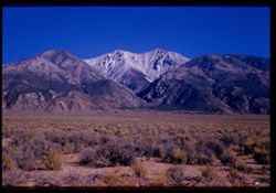
- Description:
- 100 f 9 tl
- Subject:
- Valleys, Whitney, Mount (Calif.), Mountains, Shrubs, Snow, Trees, Rocks, and Rock formations
- Series:
- 3-55
- Creator:
- Cushman, Charles W., 1896-1972
- Date Created:
- 1955-02-28
- Genre:
- Landscape photographs
- Frame Number:
- 38
- County:
- Inyo
- Abstract:
- Mt. Whitney
- Call Number:
- P07629
- Country:
- United States
- State/Province:
- California
- Alternate Identifier:
- 355.38
- Persistent URL:
- http://purl.dlib.indiana.edu/iudl/archives/cushman/P07629
-
- Description:
- 100 f 8 TL
- Subject:
- Domes, Streets, Hills, Skyscrapers, Roads, Mountains, Shrubs, Buildings, Grasses, Houses, and Dwellings
- Series:
- 12-59
- Creator:
- Cushman, Charles W., 1896-1972
- Date Created:
- 1959-05-10
- Genre:
- Cityscape photographs
- Frame Number:
- 36
- Street Address:
- Clipper Street
- County:
- San Francisco
- Abstract:
- From top of Clipper St.
- Call Number:
- P10798
- City:
- San Francisco
- Country:
- United States
- State/Province:
- California
- Alternate Identifier:
- 1259.36
- Persistent URL:
- http://purl.dlib.indiana.edu/iudl/archives/cushman/P10798
-
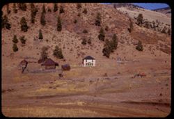
- Description:
- 25 f 11
- Subject:
- Houses, Ranches, Outbuildings, Mountains, Shrubs, Trees, and Grasses
- Series:
- 22-52
- Creator:
- Cushman, Charles W., 1896-1972
- Date Created:
- 1952-10-27
- Genre:
- Views
- Frame Number:
- 20
- County:
- Teller
- Abstract:
- Pink house 2 mi west of Cripple Creek
- Call Number:
- P06274
- City:
- Cripple Creek
- Country:
- United States
- State/Province:
- Colorado
- Alternate Identifier:
- 2252.20
- Persistent URL:
- http://purl.dlib.indiana.edu/iudl/archives/cushman/P06274