
Search Constraints
You searched for:
Campus
IUB
Remove constraint Campus: IUB
Collections
Charles W. Cushman Kodachrome Slides
Remove constraint Collections: Charles W. Cushman Kodachrome Slides
Pages
0-99 pages
Remove constraint Pages: 0-99 pages
Subject
Mountains
Remove constraint Subject: Mountains
State/Province
Texas
Remove constraint State/Province: Texas
« Previous |
1 - 50 of 71
|
Next »
Search Results
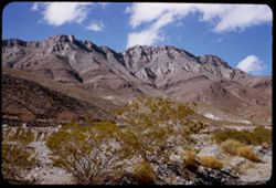
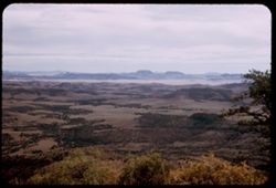
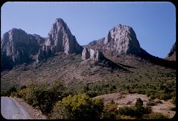
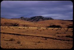
-
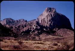
- Description:
- 25 f 11
- Subject:
- National parks & reserves, Pulliam Peak (Tex.), Green Gulch (Tex.), Valleys, Cliffs, Big Bend National Park (Tex.), Mountains, Shrubs, Basin (Big Bend Na...
- Series:
- 16-51
- Creator:
- Cushman, Charles W., 1896-1972
- Date Created:
- 1951-12-27
- Genre:
- Landscape photographs
- Frame Number:
- 4
- County:
- Brewster
- Abstract:
- Great bold front of Pulliam Pk. from Green gulch
- Call Number:
- P05423
- Country:
- United States
- State/Province:
- Texas
- Alternate Identifier:
- 1651.4
- Persistent URL:
- http://purl.dlib.indiana.edu/iudl/archives/cushman/P05423
-
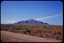
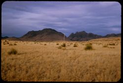
- Description:
- 50 f 8
- Subject:
- Plains, Mountains, Dirt roads, Shrubs, Sierra Blanca Mountains (Tex.), and Grasses
- Series:
- 12-53
- Creator:
- Cushman, Charles W., 1896-1972
- Date Created:
- 1953-11-15
- Genre:
- Landscape photographs
- Frame Number:
- 36
- County:
- Hudspeth
- Abstract:
- Sierra Blanca Mtn. (7000 ft)
- Call Number:
- P06954
- City:
- Sierra Blanca
- Country:
- United States
- State/Province:
- Texas
- Alternate Identifier:
- 1253.36
- Persistent URL:
- http://purl.dlib.indiana.edu/iudl/archives/cushman/P06954
-
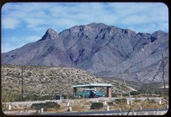
- Description:
- 50 f 8
- Subject:
- Hills, Roads, Franklin Mountains (Tex. and N.M.), Mountains, Shrubs, Shadows, and Clouds
- Series:
- 17-51
- Creator:
- Cushman, Charles W., 1896-1972
- Date Created:
- 1952-01-01
- Genre:
- Landscape photographs
- Frame Number:
- 30
- County:
- El Paso
- Abstract:
- Whorls on a Mtn. side = Franklin Mtns.
- Call Number:
- P05481
- City:
- El Paso
- Country:
- United States
- State/Province:
- Texas
- Alternate Identifier:
- 1751.30
- Persistent URL:
- http://purl.dlib.indiana.edu/iudl/archives/cushman/P05481
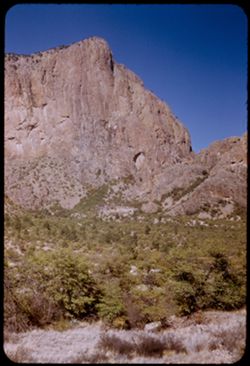
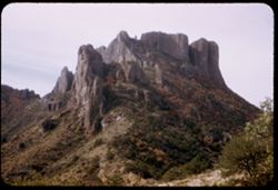
-
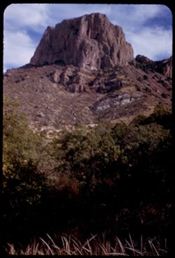
- Description:
- 25 f 9
- Subject:
- National parks & reserves, Casa Grande Peak (Tex.), Cliffs, Big Bend National Park (Tex.), Mountains, Trees, Buttes, and Rock formations
- Series:
- 16-51
- Creator:
- Cushman, Charles W., 1896-1972
- Date Created:
- 1951-12-28
- Genre:
- Landscape photographs
- Frame Number:
- 35
- County:
- Brewster
- Abstract:
- The squarish hump of Casa Grande at 2:30.
- Call Number:
- P05453
- Country:
- United States
- State/Province:
- Texas
- Alternate Identifier:
- 1651.35
- Persistent URL:
- http://purl.dlib.indiana.edu/iudl/archives/cushman/P05453
-
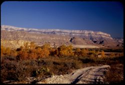
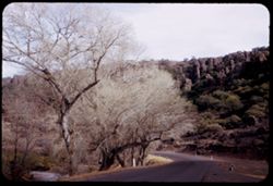
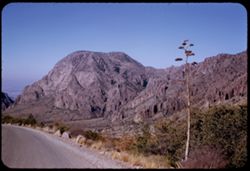
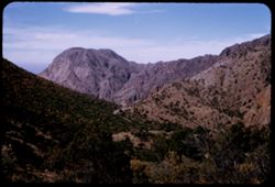
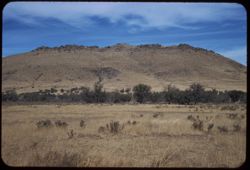
- Description:
- 50 f 8
- Subject:
- Valleys, Hills, Mountains, Lost Mine Trail (Big Bend National Park (Tex.)), Trees, Canyons, National parks & reserves, Big Bend National Park (Tex.), Cli...
- Series:
- 16-51
- Creator:
- Cushman, Charles W., 1896-1972
- Date Created:
- 1951-12-27
- Genre:
- Landscape photographs
- Frame Number:
- 11
- County:
- Brewster
- Abstract:
- Road winds down to The Basin
- Call Number:
- P05430
- Country:
- United States
- State/Province:
- Texas
- Alternate Identifier:
- 1651.11
- Persistent URL:
- http://purl.dlib.indiana.edu/iudl/archives/cushman/P05430
-
- Description:
- 25 f 9
- Subject:
- Plains, Hills, Mountains, Shrubs, Sawtooth Mountain (Tex.), and Davis Mountains State Park (Tex.)
- Series:
- 17-51
- Creator:
- Cushman, Charles W., 1896-1972
- Date Created:
- 1951-12-29
- Genre:
- Landscape photographs
- Frame Number:
- 5
- Street Address:
- Texas State Highway 166 and Loop Texas State Highway 166
- County:
- Jeff Davis
- Abstract:
- Sawtooth Mtn. from SW.
- Call Number:
- P05462
- Country:
- United States
- State/Province:
- Texas
- Alternate Identifier:
- 1751.5
- Persistent URL:
- http://purl.dlib.indiana.edu/iudl/archives/cushman/P05462
-
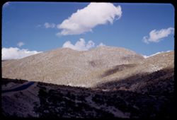
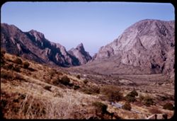
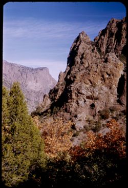
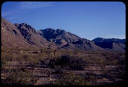
- Description:
- 25 f 11
- Subject:
- Noon, National parks & reserves, Pulliam Peak (Tex.), Canyons, Valleys, Hills, Cliffs, Big Bend National Park (Tex.), Mountains, Shrubs, Trees, Basin (Bi...
- Series:
- 16-51
- Creator:
- Cushman, Charles W., 1896-1972
- Date Created:
- 1951-12-27
- Genre:
- Landscape photographs
- Frame Number:
- 5
- County:
- Brewster
- Abstract:
- Great bold front of Pulliam Pk. From Green gulch from south
- Call Number:
- P05424
- Country:
- United States
- State/Province:
- Texas
- Alternate Identifier:
- 1651.5
- Persistent URL:
- http://purl.dlib.indiana.edu/iudl/archives/cushman/P05424
-
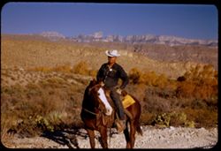
- Description:
- 125 f 4.5
- Subject:
- Horseback riding, Guards, Horses, Men, Hills, Border patrols, Boquillas Canyon (Big Bend National Park (Tex.)), Cliffs, Mountains, Shrubs, Cactus, Mounted po...
- Series:
- 16-51
- Creator:
- Cushman, Charles W., 1896-1972
- Date Created:
- 1951-12-27
- Genre:
- Portraits
- Frame Number:
- 17
- County:
- Brewster
- Abstract:
- Border patrol near Boquillas.
- Call Number:
- P05436
- Country:
- United States
- State/Province:
- Texas
- Alternate Identifier:
- 1651.17
- Persistent URL:
- http://purl.dlib.indiana.edu/iudl/archives/cushman/P05436
-
- Description:
- 25 f 11
- Subject:
- Noon, Hills, Cliffs, Franklin Mountains (Tex. and N.M.), Mountains, and Shrubs
- Series:
- 17-51
- Creator:
- Cushman, Charles W., 1896-1972
- Date Created:
- 1952-01-01
- Genre:
- Landscape photographs
- Frame Number:
- 28
- County:
- El Paso
- Abstract:
- Mtns. at noon.
- Call Number:
- P05479
- City:
- El Paso
- Country:
- United States
- State/Province:
- Texas
- Alternate Identifier:
- 1751.28
- Persistent URL:
- http://purl.dlib.indiana.edu/iudl/archives/cushman/P05479
-
- Description:
- 25 f 6.3 Pola
- Subject:
- Reserva de la Biosfera Santa Elena-Sierra del Carmen (Mexico), Cliffs, Dirt roads, Trails & paths, Trees, Mountains, National parks & reserves, Hills...
- Series:
- 16-51
- Creator:
- Cushman, Charles W., 1896-1972
- Date Created:
- 1951-12-27
- Genre:
- Landscape photographs
- Frame Number:
- 19
- County:
- Brewster
- Abstract:
- Across to Boquillas.
- Call Number:
- P05438
- Country:
- United States and Mexico
- State/Province:
- Texas
- Alternate Identifier:
- 1651.19
- Persistent URL:
- http://purl.dlib.indiana.edu/iudl/archives/cushman/P05438
-
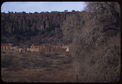
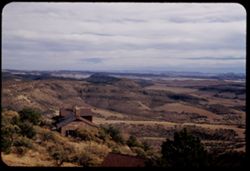
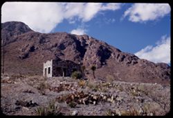
- Description:
- 100 f 5.6 tl
- Subject:
- Trees, Mountains, Buildings, Shrubs, and Fort Davis (Tex. : Fort)
- Series:
- 4-59
- Creator:
- Cushman, Charles W., 1896-1972
- Date Created:
- 1959-01-19
- Genre:
- Landscape photographs and Cityscape photographs
- Frame Number:
- 37
- County:
- Jeff Davis
- Abstract:
- Fort Davis outskirts
- Call Number:
- P10501
- City:
- Fort Davis
- Country:
- United States
- State/Province:
- Texas
- Alternate Identifier:
- 459.37
- Persistent URL:
- http://purl.dlib.indiana.edu/iudl/archives/cushman/P10501
-
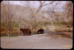
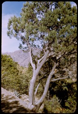
- Description:
- 25 f 6.3
- Subject:
- Canyons, Horses, Trees, Mountains, Shrubs, Cows, and Streams
- Series:
- 17-51
- Creator:
- Cushman, Charles W., 1896-1972
- Date Created:
- 1951-12-29
- Genre:
- Identification photographs
- Frame Number:
- 1
- County:
- Jeff Davis
- Abstract:
- Horses + cows at a stream north of Ft. Davis a few miles.
- Call Number:
- P05458
- City:
- Fort Davis
- Country:
- United States
- State/Province:
- Texas
- Alternate Identifier:
- 1751.1
- Persistent URL:
- http://purl.dlib.indiana.edu/iudl/archives/cushman/P05458
-
- Description:
- 25 f 8
- Subject:
- Cliffs, Trees, Mountains, Rock formations, Cottonwood, Hills, Streams, and Roads
- Series:
- 17-51
- Creator:
- Cushman, Charles W., 1896-1972
- Date Created:
- 1951-12-29
- Genre:
- Landscape photographs and Identification photographs
- Frame Number:
- 3
- Street Address:
- Texas State Highway 118
- County:
- Jeff Davis
- Abstract:
- Cottonwoods along Hwy 118 north of Ft. Davis.
- Call Number:
- P05460
- City:
- Fort Davis
- Country:
- United States
- State/Province:
- Texas
- Alternate Identifier:
- 1751.3
- Persistent URL:
- http://purl.dlib.indiana.edu/iudl/archives/cushman/P05460
-
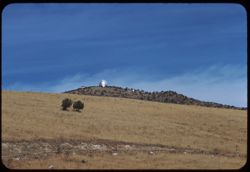
- Description:
- 100 f 8 tl
- Subject:
- Trees, McDonald Observatory, Mountains, Astronomical observatories, Shrubs, and Dwellings
- Series:
- 5-59
- Creator:
- Cushman, Charles W., 1896-1972
- Date Created:
- 1959-01-19
- Genre:
- Landscape photographs
- Frame Number:
- 2
- County:
- Jeff Davis
- Abstract:
- McDonald Observatory atop a Davis Mtn 17,777.7 miles
- Call Number:
- P10503
- City:
- Fort Davis
- Country:
- United States
- State/Province:
- Texas
- Alternate Identifier:
- 559.2
- Persistent URL:
- http://purl.dlib.indiana.edu/iudl/archives/cushman/P10503
-
- Description:
- 100 f 6.3 tl
- Subject:
- Rocks, Roads, Davis Mountains (Tex.), Signs (Notices), Mountains, Fences, and Shrubs
- Series:
- 4-59
- Creator:
- Cushman, Charles W., 1896-1972
- Date Created:
- 1959-01-19
- Genre:
- Landscape photographs
- Frame Number:
- 35
- County:
- Jeff Davis and Brewster
- Abstract:
- Toward Davis Mtns.
- Call Number:
- P10499
- City:
- Fort Davis and Alpine
- Country:
- United States
- State/Province:
- Texas
- Alternate Identifier:
- 459.35
- Persistent URL:
- http://purl.dlib.indiana.edu/iudl/archives/cushman/P10499
-
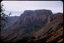
- Description:
- 25 f 4.5 Pola
- Subject:
- Cliffs, Mountains, National parks & reserves, Toll Mountain (Tex.), Lost Mine Trail (Big Bend National Park (Tex.)), Big Bend National Park (Tex.), and S...
- Series:
- 16-51
- Creator:
- Cushman, Charles W., 1896-1972
- Date Created:
- 1951-12-28
- Genre:
- Landscape photographs
- Frame Number:
- 25
- County:
- Brewster
- Abstract:
- Toll Mtn. from Lost mine Trail 3/4 mi.
- Call Number:
- P05443
- Country:
- United States
- State/Province:
- Texas
- Alternate Identifier:
- 1651.25
- Persistent URL:
- http://purl.dlib.indiana.edu/iudl/archives/cushman/P05443
-
- Description:
- 25 f 11
- Subject:
- Cliffs, Trees, Pulliam Peak (Tex.), Mountains, Shrubs, Lost Mine Trail (Big Bend National Park (Tex.)), Big Bend National Park (Tex.), Lost Mine Peak (Tex.),...
- Series:
- 16-51
- Creator:
- Cushman, Charles W., 1896-1972
- Date Created:
- 1951-12-28
- Genre:
- Landscape photographs
- Frame Number:
- 21
- County:
- Brewster
- Abstract:
- Looking past Lost Mine Peak to Pulliam Pk.
- Call Number:
- P05440
- Country:
- United States
- State/Province:
- Texas
- Alternate Identifier:
- 1651.21
- Persistent URL:
- http://purl.dlib.indiana.edu/iudl/archives/cushman/P05440
-
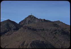
- Description:
- 100 f 8 tl
- Subject:
- Rocks, Crosses, Boundaries, Stonework, Hueco Mountains (Tex. and N.M.), Mountains, US-Mexican border, and Clouds
- Series:
- 5-59
- Creator:
- Cushman, Charles W., 1896-1972
- Date Created:
- 1959-01-21
- Genre:
- Landscape photographs
- Frame Number:
- 10
- County:
- El Paso
- Abstract:
- Stone cross atop rough ridge along border NW of El Paso
- Call Number:
- P10511
- City:
- El Paso
- Country:
- United States
- State/Province:
- Texas
- Alternate Identifier:
- 559.10
- Persistent URL:
- http://purl.dlib.indiana.edu/iudl/archives/cushman/P10511
-
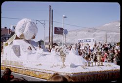
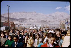
- Subject:
- Cotton queen, Spectators, Chevron Oil Company, Parades & processions, Signs (Notices), Streets, Automobile service stations, Mountains, Street lights, El...
- Series:
- 17-51
- Creator:
- Cushman, Charles W., 1896-1972
- Date Created:
- 1952-01-01
- Genre:
- Snapshots and Portraits
- Frame Number:
- 20
- County:
- El Paso
- Abstract:
- a few at f 5.6, 15 to 26 = Paraders, floats, onlookers. 125 f 4.5, and some at f 4
- Call Number:
- P05472
- City:
- El Paso
- Country:
- United States
- State/Province:
- Texas
- Alternate Identifier:
- 1751.20
- Persistent URL:
- http://purl.dlib.indiana.edu/iudl/archives/cushman/P05472
-
- Description:
- 50 f 8
- Subject:
- Rocks, Cliffs, Mountains, National parks & reserves, Big Bend National Park (Tex.), Roads, and Shrubs
- Series:
- 16-51
- Creator:
- Cushman, Charles W., 1896-1972
- Date Created:
- 1951-12-27
- Genre:
- Landscape photographs and Panoramic views
- Frame Number:
- 7
- County:
- Brewster
- Abstract:
- Panorama
- Call Number:
- P05426
- Country:
- United States
- State/Province:
- Texas
- Alternate Identifier:
- 1651.7
- Persistent URL:
- http://purl.dlib.indiana.edu/iudl/archives/cushman/P05426
-
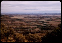
- Description:
- 25 f 5.6 Pola
- Subject:
- Valleys, Davis Mountains State Park (Tex.), Trees, Locke, Mount (Tex.), Tree limbs, Mountains, and Hills
- Series:
- 16-51
- Creator:
- Cushman, Charles W., 1896-1972
- Date Created:
- 1951-12-29
- Genre:
- Landscape photographs
- Frame Number:
- 38
- County:
- Jeff Davis
- Abstract:
- South from Mt. Locke.
- Call Number:
- P05456
- Country:
- United States
- State/Province:
- Texas
- Alternate Identifier:
- 1651.38
- Persistent URL:
- http://purl.dlib.indiana.edu/iudl/archives/cushman/P05456
-
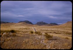
- Description:
- 25 f 11
- Subject:
- Rocks, Barbed wire, Mountains, Fences, Shrubs, Hills, and Big Bend National Park (Tex.)
- Series:
- 15-51
- Creator:
- Cushman, Charles W., 1896-1972
- Date Created:
- 1951-12-27
- Genre:
- Landscape photographs and Identification photographs
- Frame Number:
- 39
- Street Address:
- United States Highway 227
- County:
- Brewster
- Abstract:
- Mtn 28 miles south of Marathon on US 227
- Call Number:
- P05419
- City:
- Marathon
- Country:
- United States
- State/Province:
- Texas
- Alternate Identifier:
- 1551.39
- Persistent URL:
- http://purl.dlib.indiana.edu/iudl/archives/cushman/P05419
-
- Description:
- 25 f 11
- Subject:
- Canyons, Roads, Trees, Tree limbs, Mountains, Shrubs, Lost Mine Trail (Big Bend National Park (Tex.)), Hills, Big Bend National Park (Tex.), and National par...
- Series:
- 16-51
- Creator:
- Cushman, Charles W., 1896-1972
- Date Created:
- 1951-12-28
- Genre:
- Landscape photographs
- Frame Number:
- 29
- County:
- Brewster
- Abstract:
- View west down canyon.
- Call Number:
- P05447
- Country:
- United States
- State/Province:
- Texas
- Alternate Identifier:
- 1651.29
- Persistent URL:
- http://purl.dlib.indiana.edu/iudl/archives/cushman/P05447
-
- Subject:
- Crowds, Electric lines, Floats (Parades), Signs (Notices), Sun Bowl Parade (El Paso, Tex.), Onlookers, Mountains, Buildings, Electric signs, Parades & pr...
- Series:
- 17-51
- Creator:
- Cushman, Charles W., 1896-1972
- Date Created:
- 1952-01-01
- Genre:
- Snapshots
- Frame Number:
- 25
- County:
- El Paso
- Abstract:
- a few at f 5.6, 15 to 26 = Paraders, floats, onlookers. 125 f 4.5, and some at f 4
- Call Number:
- P05476
- City:
- El Paso
- Country:
- United States
- State/Province:
- Texas
- Alternate Identifier:
- 1751.25
- Persistent URL:
- http://purl.dlib.indiana.edu/iudl/archives/cushman/P05476
-
- Description:
- 50 f 6.3
- Subject:
- Roads, Trees, Buttes, Mountains, National parks & reserves, Hills, Big Bend National Park (Tex.), Cliffs, Shrubs, and Rock formations
- Series:
- 16-51
- Creator:
- Cushman, Charles W., 1896-1972
- Date Created:
- 1951-12-27
- Genre:
- Landscape photographs
- Frame Number:
- 6
- County:
- Brewster
- Abstract:
- 3 Jags
- Call Number:
- P05425
- Country:
- United States
- State/Province:
- Texas
- Alternate Identifier:
- 1651.6
- Persistent URL:
- http://purl.dlib.indiana.edu/iudl/archives/cushman/P05425
-
- Description:
- 25 f 8 Pola
- Subject:
- Houses, Davis Mountains State Park (Tex.), Trees, Locke, Mount (Tex.), Tree limbs, Mountains, Shrubs, and Hills
- Series:
- 16-51
- Creator:
- Cushman, Charles W., 1896-1972
- Date Created:
- 1951-12-29
- Genre:
- Landscape photographs
- Frame Number:
- 39
- County:
- Jeff Davis
- Abstract:
- East Sou. East from Mt. Locke.
- Call Number:
- P05457
- Country:
- United States
- State/Province:
- Texas
- Alternate Identifier:
- 1651.39
- Persistent URL:
- http://purl.dlib.indiana.edu/iudl/archives/cushman/P05457
-
- Description:
- 25 f 4 Pola
- Subject:
- Cliffs, Trees, Buttes, Mountains, Rock formations, Lost Mine Trail (Big Bend National Park (Tex.)), Casa Grande Peak (Tex.), Big Bend National Park (Tex.), N...
- Series:
- 16-51
- Creator:
- Cushman, Charles W., 1896-1972
- Date Created:
- 1951-12-28
- Genre:
- Landscape photographs
- Frame Number:
- 26
- County:
- Brewster
- Abstract:
- Casa Grande Mtn. from Lost Mine Trail 3/4 mi. pt.
- Call Number:
- P05444
- Country:
- United States
- State/Province:
- Texas
- Alternate Identifier:
- 1651.26
- Persistent URL:
- http://purl.dlib.indiana.edu/iudl/archives/cushman/P05444
-
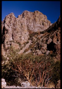
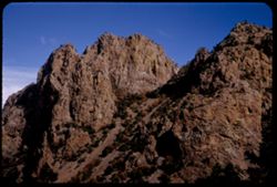
- Description:
- 25 f 11
- Subject:
- Rocks, Cliffs, Trees, Lost Mine Peak (Tex.), Mountains, Shrubs, Big Bend National Park (Tex.), and National parks & reserves
- Series:
- 16-51
- Creator:
- Cushman, Charles W., 1896-1972
- Date Created:
- 1951-12-27
- Genre:
- Landscape photographs
- Frame Number:
- 12
- County:
- Brewster
- Persons Pictured:
- Cushman, Charles W. (Charles Weever), 1896-1972
- Abstract:
- Green on high rock face of Lost Mine Peak
- Call Number:
- P05431
- Country:
- United States
- State/Province:
- Texas
- Physical Description:
- Image was originally mounted in a glass enclosure. Before digitization, the image was removed and placed in a Wess Plastic, Inc. brand, 2" x 2", pl...
- Alternate Identifier:
- 1651.12
- Persistent URL:
- http://purl.dlib.indiana.edu/iudl/archives/cushman/P05431
-

- Subject:
- Crowds, Parades & processions, Signs (Notices), Sun Bowl Parade (El Paso, Tex.), Onlookers, Mountains, Buildings, Festivals, People, Floats (Parades), St...
- Series:
- 17-51
- Creator:
- Cushman, Charles W., 1896-1972
- Date Created:
- 1952-01-01
- Genre:
- Snapshots
- Frame Number:
- 24
- County:
- El Paso
- Abstract:
- a few at f 5.6, 15 to 26 = Paraders, floats, onlookers. 125 f 4.5, and some at f 4
- Call Number:
- P05475
- City:
- El Paso
- Country:
- United States
- State/Province:
- Texas
- Alternate Identifier:
- 1751.24
- Persistent URL:
- http://purl.dlib.indiana.edu/iudl/archives/cushman/P05475
-
- Description:
- 100 f 6 tl
- Subject:
- Electric lines, Devil Ridge (Tex.), Mountains, Shrubs, Clouds, and Sierra Blanca Mountains (Tex.)
- Series:
- 5-59
- Creator:
- Cushman, Charles W., 1896-1972
- Date Created:
- 1959-01-19
- Genre:
- Landscape photographs
- Frame Number:
- 4
- County:
- Hudspeth
- Abstract:
- Sierra Blanca Mtn.
- Call Number:
- P10505
- City:
- Sierra Blanca
- Country:
- United States
- State/Province:
- Texas
- Alternate Identifier:
- 559.4
- Persistent URL:
- http://purl.dlib.indiana.edu/iudl/archives/cushman/P10505
-
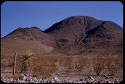
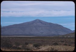
- Description:
- 100 f 4.5 tl
- Subject:
- Mountains
- Series:
- 4-59
- Creator:
- Cushman, Charles W., 1896-1972
- Date Created:
- 1959-01-18
- Genre:
- Landscape photographs
- Frame Number:
- 34
- County:
- Brewster
- Abstract:
- Mtns s.e. of Alpine seen from south in light of setting sun
- Call Number:
- P10498
- City:
- Alpine
- Country:
- United States
- State/Province:
- Texas
- Alternate Identifier:
- 459.34
- Persistent URL:
- http://purl.dlib.indiana.edu/iudl/archives/cushman/P10498
-
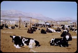
- Description:
- 25 f 11
- Subject:
- Feed lot, Cattle, Animal feeding, Mountains, Fences, and Trucks
- Series:
- 17-51
- Creator:
- Cushman, Charles W., 1896-1972
- Date Created:
- 1952-01-02
- Genre:
- Snapshots
- Frame Number:
- 35
- Street Address:
- Reynolds Street and Montana Street
- County:
- El Paso
- Abstract:
- Feed lot - El Paso - Reynolds St. south of Montana.
- Call Number:
- P05486
- City:
- El Paso
- Country:
- United States
- State/Province:
- Texas
- Alternate Identifier:
- 1751.35
- Persistent URL:
- http://purl.dlib.indiana.edu/iudl/archives/cushman/P05486
-
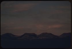
- Description:
- 100 f 6.3 tl
- Subject:
- Electric lines, Davis Mountains (Tex.), Mountains, Shrubs, Clouds, and Grasses
- Series:
- 5-59
- Creator:
- Cushman, Charles W., 1896-1972
- Date Created:
- 1959-01-19
- Genre:
- Landscape photographs
- Frame Number:
- 1
- County:
- Jeff Davis
- Abstract:
- Low broad mtn.
- Call Number:
- P10502
- City:
- Fort Davis
- Country:
- United States
- State/Province:
- Texas
- Alternate Identifier:
- 559.1
- Persistent URL:
- http://purl.dlib.indiana.edu/iudl/archives/cushman/P10502
-
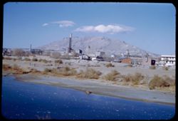
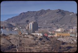
- Description:
- 50 f 8
- Subject:
- Franklin Mountains (Tex. and N.M.), Industrial facilities, Rio Grande, Mountains, Buildings, Shrubs, People, Smokestacks, and Rivers
- Series:
- 1-52
- Creator:
- Cushman, Charles W., 1896-1972
- Date Created:
- 1952-01-02
- Genre:
- Cityscape photographs
- Frame Number:
- 9
- County:
- El Paso
- Abstract:
- El Paso from Juarez.
- Call Number:
- P05499
- City:
- El Paso
- Country:
- United States
- State/Province:
- Texas
- Alternate Identifier:
- 152.9
- Persistent URL:
- http://purl.dlib.indiana.edu/iudl/archives/cushman/P05499
-
- Description:
- 25 f 6.3 Pola
- Subject:
- Trees, Locke, Mount (Tex.), Davis Mountains (Tex.), Mountains, Shrubs, and Hills
- Series:
- 16-51
- Creator:
- Cushman, Charles W., 1896-1972
- Date Created:
- 1951-12-29
- Genre:
- Landscape photographs and Panoramic views
- Frame Number:
- 37
- County:
- Jeff Davis
- Abstract:
- Panorama SE from top of Mt. Locke.
- Call Number:
- P05455
- Country:
- United States
- State/Province:
- Texas
- Alternate Identifier:
- 1651.37
- Persistent URL:
- http://purl.dlib.indiana.edu/iudl/archives/cushman/P05455
-
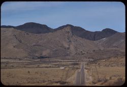
- Description:
- 25 f 11
- Subject:
- Rocks, Roads, Davis Mountains State Park (Tex.), Sawtooth Mountain (Tex.), Plains, Mountains, Shrubs, and Hills
- Series:
- 17-51
- Creator:
- Cushman, Charles W., 1896-1972
- Date Created:
- 1951-12-29
- Genre:
- Landscape photographs
- Frame Number:
- 4
- Street Address:
- Texas State Highway 166 and Loop Texas State Highway 166
- County:
- Jeff Davis
- Abstract:
- North on Loop Tex 166 toward Sawtooth Mt. In Davis.
- Call Number:
- P05461
- City:
- Fort Davis
- Country:
- United States
- State/Province:
- Texas
- Alternate Identifier:
- 1751.4
- Persistent URL:
- http://purl.dlib.indiana.edu/iudl/archives/cushman/P05461
-
- Description:
- 25 f 9
- Subject:
- Cliffs, Trees, Buttes, Mountains, National parks & reserves, Lost Mine Trail (Big Bend National Park (Tex.)), Casa Grande Peak (Tex.), Big Bend National ...
- Series:
- 16-51
- Creator:
- Cushman, Charles W., 1896-1972
- Date Created:
- 1951-12-28
- Genre:
- Landscape photographs
- Frame Number:
- 22
- County:
- Brewster
- Abstract:
- Up at Casa Grande
- Call Number:
- P05441
- Country:
- United States
- State/Province:
- Texas
- Alternate Identifier:
- 1651.22
- Persistent URL:
- http://purl.dlib.indiana.edu/iudl/archives/cushman/P05441
-
- Description:
- 50 f 8
- Subject:
- Quitman Mountains (Tex.), Mountains, Shrubs, Rocks, and Grasses
- Series:
- 12-53
- Creator:
- Cushman, Charles W., 1896-1972
- Date Created:
- 1953-11-15
- Genre:
- Landscape photographs
- Frame Number:
- 37
- Street Address:
- United States Highway 80
- County:
- El Paso and Hudspeth
- Abstract:
- Quitman Mtns from loop of US 80 - 75 mi. from El Paso
- Call Number:
- P06955
- City:
- El Paso
- Country:
- United States
- State/Province:
- Texas
- Alternate Identifier:
- 1253.37
- Persistent URL:
- http://purl.dlib.indiana.edu/iudl/archives/cushman/P06955
-
- Description:
- 100 f 8 tl
- Subject:
- Cities & towns, Franklin Mountains (Tex. and N.M.), Mountains, Shrubs, Rocks, Vehicles, and Buildings
- Series:
- 5-59
- Creator:
- Cushman, Charles W., 1896-1972
- Date Created:
- 1959-01-21
- Genre:
- Cityscape photographs
- Frame Number:
- 30
- County:
- El Paso
- Abstract:
- Franklin Mtns from Cd. Juarez
- Call Number:
- P10531
- City:
- Ciudad Juárez and El Paso
- Country:
- Mexico and United States
- State/Province:
- Chihuahua and Texas
- Alternate Identifier:
- 559.30
- Persistent URL:
- http://purl.dlib.indiana.edu/iudl/archives/cushman/P10531
-
- Subject:
- Horseback riding, Tree limbs, Billboards, Horses, Streets, Sun Bowl Parade (El Paso, Tex.), Spectators, Mountains, People, Onlookers, Floats (Parades), Build...
- Series:
- 17-51
- Creator:
- Cushman, Charles W., 1896-1972
- Date Created:
- 1952-01-01
- Genre:
- Portraits and Snapshots
- Frame Number:
- 22
- County:
- El Paso
- Abstract:
- some at f 4, a few at f 5.6, and 15 to 26 = Paraders, floats, onlookers. 125 f 4.5
- Call Number:
- P05474
- City:
- El Paso
- Country:
- United States
- State/Province:
- Texas
- Alternate Identifier:
- 1751.22
- Persistent URL:
- http://purl.dlib.indiana.edu/iudl/archives/cushman/P05474
-
- Description:
- 25 f 9
- Subject:
- Lost Mine Trail (Big Bend National Park (Tex.)), Tree limbs, Big Bend National Park (Tex.), Mountains, Shrubs, Trees, Trails & paths, Junipers, and Natio...
- Series:
- 16-51
- Creator:
- Cushman, Charles W., 1896-1972
- Date Created:
- 1951-12-28
- Genre:
- Identification photographs
- Frame Number:
- 20
- County:
- Brewster
- Abstract:
- Alligator Juniper
- Call Number:
- P05439
- Country:
- United States
- State/Province:
- Texas
- Alternate Identifier:
- 1651.20
- Persistent URL:
- http://purl.dlib.indiana.edu/iudl/archives/cushman/P05439
-
- Description:
- 50 f 8
- Subject:
- Hills, Davis Mountains State Park (Tex.), Shrubs, Sawtooth Mountain (Tex.), and Mountains
- Series:
- 17-51
- Creator:
- Cushman, Charles W., 1896-1972
- Date Created:
- 1951-12-29
- Genre:
- Landscape photographs
- Frame Number:
- 6
- Street Address:
- Texas State Highway 166 and Loop Texas State Highway 166
- County:
- Jeff Davis
- Abstract:
- A mtn. south of Sawtooth.
- Call Number:
- P05463
- Country:
- United States
- State/Province:
- Texas
- Alternate Identifier:
- 1751.6
- Persistent URL:
- http://purl.dlib.indiana.edu/iudl/archives/cushman/P05463
-
- Description:
- 100 f 8 tl
- Subject:
- Automobiles, Franklin Mountains (Tex. and N.M.), Mountains, People, Shrubs, Electric lines, Rest stops, and Trees
- Series:
- 5-59
- Creator:
- Cushman, Charles W., 1896-1972
- Date Created:
- 1959-01-21
- Genre:
- Landscape photographs
- Frame Number:
- 12
- County:
- El Paso
- Abstract:
- Top knot along ridge of Franklin Mtns.
- Call Number:
- P10513
- City:
- El Paso
- Country:
- United States
- State/Province:
- Texas
- Alternate Identifier:
- 559.12
- Persistent URL:
- http://purl.dlib.indiana.edu/iudl/archives/cushman/P10513
-
- Description:
- 25 f 11
- Subject:
- Lost Mine Trail (Big Bend National Park (Tex.)), National parks & reserves, Cliffs, Big Bend National Park (Tex.), Mountains, Shrubs, Trees, and Lost Min...
- Series:
- 16-51
- Creator:
- Cushman, Charles W., 1896-1972
- Date Created:
- 1951-12-28
- Genre:
- Landscape photographs
- Frame Number:
- 32
- County:
- Brewster
- Abstract:
- From further down
- Call Number:
- P05450
- Country:
- United States
- State/Province:
- Texas
- Alternate Identifier:
- 1651.32
- Persistent URL:
- http://purl.dlib.indiana.edu/iudl/archives/cushman/P05450
-
- Description:
- 50 f 8
- Subject:
- Stone buildings, Houses, Facades, Windows, Franklin Mountains (Tex. and N.M.), Mountains, Stone houses, Utility poles, Cactus, Trees, Doors & doorways, a...
- Series:
- 17-51
- Creator:
- Cushman, Charles W., 1896-1972
- Date Created:
- 1952-01-01
- Genre:
- Landscape photographs and Architectural photographs
- Frame Number:
- 31
- County:
- El Paso
- Abstract:
- Stone house + mtn. backdrop - Franklin Mtns.
- Call Number:
- P05482
- City:
- El Paso
- Country:
- United States
- State/Province:
- Texas
- Alternate Identifier:
- 1751.31
- Persistent URL:
- http://purl.dlib.indiana.edu/iudl/archives/cushman/P05482
-
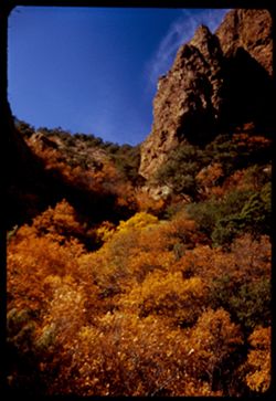
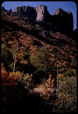
- Description:
- 25 f 5.6 Pola
- Subject:
- Leaves, Tree limbs, Canyons, Autumn, Cliffs, Big Bend National Park (Tex.), Mountains, Trees, Colors, Rock formations, and National parks & reserves
- Series:
- 16-51
- Creator:
- Cushman, Charles W., 1896-1972
- Date Created:
- 1951-12-28
- Genre:
- Landscape photographs
- Frame Number:
- 34
- County:
- Brewster
- Abstract:
- Colors up a canyon.
- Call Number:
- P05452
- Country:
- United States
- State/Province:
- Texas
- Alternate Identifier:
- 1651.34
- Persistent URL:
- http://purl.dlib.indiana.edu/iudl/archives/cushman/P05452
-
- Description:
- 50 f 9
- Subject:
- Water towers, Plains, Hills, Roads, Franklin Mountains (Tex. and N.M.), Mountains, Shrubs, Shadows, Clouds, Buildings, and Rocks
- Series:
- 17-51
- Creator:
- Cushman, Charles W., 1896-1972
- Date Created:
- 1952-01-01
- Genre:
- Landscape photographs and Cityscape photographs
- Frame Number:
- 32
- County:
- El Paso
- Abstract:
- Strange long cloud over Fort Bliss from Franklin Mtns.
- Call Number:
- P05483
- City:
- Fort Bliss
- Country:
- United States
- State/Province:
- Texas
- Alternate Identifier:
- 1751.32
- Persistent URL:
- http://purl.dlib.indiana.edu/iudl/archives/cushman/P05483
-
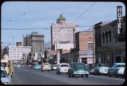
- Description:
- 50 f 9 tl
- Subject:
- Streets, Automobiles, Mountains, People, Electric lines, Stores & shops, Buildings, and Signs (Notices)
- Series:
- 5-59
- Creator:
- Cushman, Charles W., 1896-1972
- Date Created:
- 1959-01-21
- Genre:
- Cityscape photographs
- Frame Number:
- 8
- Street Address:
- El Paso Street
- County:
- El Paso
- Abstract:
- View north up El Paso St.
- Call Number:
- P10509
- City:
- El Paso
- Country:
- United States
- State/Province:
- Texas
- Alternate Identifier:
- 559.8
- Persistent URL:
- http://purl.dlib.indiana.edu/iudl/archives/cushman/P10509
-
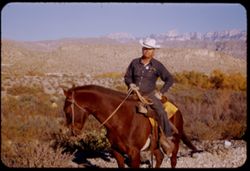
- Description:
- 50 f 6.3
- Subject:
- Horseback riding, Guards, Rio Grande, Horses, Men, Hills, Border patrols, Boquillas Canyon (Big Bend National Park (Tex.)), Cliffs, Rangers, Shrubs, Mounted ...
- Series:
- 16-51
- Creator:
- Cushman, Charles W., 1896-1972
- Date Created:
- 1951-12-27
- Genre:
- Portraits
- Frame Number:
- 18
- County:
- Brewster
- Abstract:
- Border patrol near Boquillas.
- Call Number:
- P05437
- Country:
- United States
- State/Province:
- Texas
- Alternate Identifier:
- 1651.18
- Persistent URL:
- http://purl.dlib.indiana.edu/iudl/archives/cushman/P05437
-
- Description:
- 50 f 6.3 Pola
- Subject:
- National parks & reserves, Cliffs, Big Bend National Park (Tex.), Mountains, Shrubs, Buttes, and Rock formations
- Series:
- 16-51
- Creator:
- Cushman, Charles W., 1896-1972
- Date Created:
- 1951-12-27
- Genre:
- Landscape photographs
- Frame Number:
- 1
- County:
- Brewster
- Abstract:
- In Big Bend Pk. Error
- Call Number:
- P05420
- Country:
- United States
- State/Province:
- Texas
- Physical Description:
- masked.
- Alternate Identifier:
- 1651.1
- Persistent URL:
- http://purl.dlib.indiana.edu/iudl/archives/cushman/P05420