
Search Constraints
You searched for:
Campus
IUB
Remove constraint Campus: IUB
Collections
Charles W. Cushman Kodachrome Slides
Remove constraint Collections: Charles W. Cushman Kodachrome Slides
Subject
Deserts
Remove constraint Subject: Deserts
Search Results
-
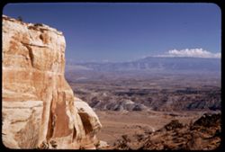
- Description:
- 25 f 6.3 Pola
- Subject:
- Deserts, Cliffs, Colorado National Monument (Colo.), Mesas, Buttes, Mountains, Shrubs, Clouds, Roads, Trees, and National parks & reserves
- Series:
- 26-52
- Creator:
- Cushman, Charles W., 1896-1972
- Date Created:
- 1952-11-03
- Genre:
- Landscape photographs
- Frame Number:
- 5
- County:
- Mesa
- Abstract:
- View over Grnd Juctn.
- Call Number:
- P06412
- City:
- Grand Junction
- Country:
- United States
- State/Province:
- Colorado
- Alternate Identifier:
- 2652.5
- Persistent URL:
- http://purl.dlib.indiana.edu/iudl/archives/cushman/P06412
- Holding Location:
- Bloomington - University Archives
Wells Library E460
1320 E 10th St.
Bloomington, IN 47405
Contact at archives@indiana.edu, 812-855-1127
-
- Description:
- 25 f 8 pola
- Subject:
- Deserts, Mesas, Harvey Inn (Holbrook, Ariz.), Rock formations, Hills, Painted Desert (Ariz.), and Shrubs
- Series:
- 17-52
- Creator:
- Cushman, Charles W., 1896-1972
- Date Created:
- 1952-04-13
- Genre:
- Landscape photographs
- Frame Number:
- 39
- County:
- Apache and Navajo
- Abstract:
- NW from same pt.
- Call Number:
- P06131
- City:
- Holbrook
- Country:
- United States
- State/Province:
- Arizona
- Alternate Identifier:
- 1752.39
- Persistent URL:
- http://purl.dlib.indiana.edu/iudl/archives/cushman/P06131
- Holding Location:
- Bloomington - University Archives
Wells Library E460
1320 E 10th St.
Bloomington, IN 47405
Contact at archives@indiana.edu, 812-855-1127
-
- Description:
- 25 f 8 pola
- Subject:
- Deserts, Mesas, Harvey Inn (Holbrook, Ariz.), Shrubs, Hills, Painted Desert (Ariz.), and Rock formations
- Series:
- 17-52
- Creator:
- Cushman, Charles W., 1896-1972
- Date Created:
- 1952-04-13
- Genre:
- Landscape photographs
- Frame Number:
- 38
- County:
- Apache and Navajo
- Abstract:
- SE from Harvey Inn
- Call Number:
- P06130
- City:
- Holbrook
- Country:
- United States
- State/Province:
- Arizona
- Physical Description:
- Image was originally mounted in a glass enclosure. Before digitization, the image was removed and placed in a Wess Plastic, Inc. brand, 2" x 2", pl...
- Alternate Identifier:
- 1752.38
- Persistent URL:
- http://purl.dlib.indiana.edu/iudl/archives/cushman/P06130
- Holding Location:
- Bloomington - University Archives
Wells Library E460
1320 E 10th St.
Bloomington, IN 47405
Contact at archives@indiana.edu, 812-855-1127
-
- Description:
- 25 f 11 pola
- Subject:
- Petrified Forest National Park (Ariz.), National parks & reserves, Deserts, Canyons, Hills, Cliffs, Shrubs, Boulders, Rocks, Rock formations, Mesas, Petr...
- Series:
- 17-52
- Creator:
- Cushman, Charles W., 1896-1972
- Date Created:
- 1952-04-13
- Genre:
- Landscape photographs
- Frame Number:
- 36
- County:
- Apache
- Abstract:
- In Blue Forest 113737
- Call Number:
- P06128
- Country:
- United States
- State/Province:
- Arizona
- Alternate Identifier:
- 1752.36
- Persistent URL:
- http://purl.dlib.indiana.edu/iudl/archives/cushman/P06128
- Holding Location:
- Bloomington - University Archives
Wells Library E460
1320 E 10th St.
Bloomington, IN 47405
Contact at archives@indiana.edu, 812-855-1127
-
- Description:
- 25 f 11 pola
- Subject:
- Rocks, Boulders, Petrified Forest National Park (Ariz.), Mountains, Rock formations, Hills, Deserts, and National parks & reserves
- Series:
- 17-52
- Creator:
- Cushman, Charles W., 1896-1972
- Date Created:
- 1952-04-13
- Genre:
- Landscape photographs
- Frame Number:
- 28
- County:
- Apache
- Abstract:
- Bad lands
- Call Number:
- P06120
- City:
- Badlands
- Country:
- United States
- State/Province:
- Arizona
- Alternate Identifier:
- 1752.28
- Persistent URL:
- http://purl.dlib.indiana.edu/iudl/archives/cushman/P06120
- Holding Location:
- Bloomington - University Archives
Wells Library E460
1320 E 10th St.
Bloomington, IN 47405
Contact at archives@indiana.edu, 812-855-1127
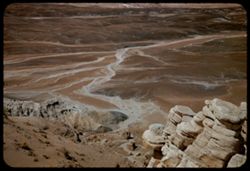
-
- Description:
- 25 f 11 pola
- Subject:
- Petrified Forest National Park (Ariz.), National parks & reserves, Deserts, Hills, Automobiles, Roads, Boulders, Rocks, Trails & paths, Signs (Notice...
- Series:
- 17-52
- Creator:
- Cushman, Charles W., 1896-1972
- Date Created:
- 1952-04-13
- Genre:
- Landscape photographs
- Frame Number:
- 27
- County:
- Apache
- Abstract:
- Bad lands
- Call Number:
- P06119
- City:
- Badlands
- Country:
- United States
- State/Province:
- Arizona
- Alternate Identifier:
- 1752.27
- Persistent URL:
- http://purl.dlib.indiana.edu/iudl/archives/cushman/P06119
- Holding Location:
- Bloomington - University Archives
Wells Library E460
1320 E 10th St.
Bloomington, IN 47405
Contact at archives@indiana.edu, 812-855-1127
-
- Description:
- 25 f 11 pola
- Subject:
- Rocks, Valleys, Cliffs, Mesas, Boulders, Petrified Forest National Park (Ariz.), National parks & reserves, Hills, and Deserts
- Series:
- 17-52
- Creator:
- Cushman, Charles W., 1896-1972
- Date Created:
- 1952-04-13
- Genre:
- Landscape photographs
- Frame Number:
- 26
- County:
- Apache
- Abstract:
- Bad lands
- Call Number:
- P06118
- City:
- Badlands
- Country:
- United States
- State/Province:
- Arizona
- Alternate Identifier:
- 1752.26
- Persistent URL:
- http://purl.dlib.indiana.edu/iudl/archives/cushman/P06118
- Holding Location:
- Bloomington - University Archives
Wells Library E460
1320 E 10th St.
Bloomington, IN 47405
Contact at archives@indiana.edu, 812-855-1127
-
- Description:
- 25 f 11
- Subject:
- Rocks, Sightseers, Petrified forests, Petrified Forest National Park (Ariz.), National parks & reserves, Logs, Hills, People, Petrified wood, Deserts, an...
- Series:
- 17-52
- Creator:
- Cushman, Charles W., 1896-1972
- Date Created:
- 1952-04-13
- Genre:
- Landscape photographs
- Frame Number:
- 24
- County:
- Apache
- Abstract:
- Panorama with Easter visitors
- Call Number:
- P06117
- Country:
- United States
- State/Province:
- Arizona
- Alternate Identifier:
- 1752.24
- Persistent URL:
- http://purl.dlib.indiana.edu/iudl/archives/cushman/P06117
- Holding Location:
- Bloomington - University Archives
Wells Library E460
1320 E 10th St.
Bloomington, IN 47405
Contact at archives@indiana.edu, 812-855-1127
-
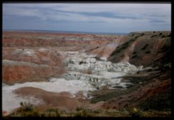
- Description:
- 25 f 16
- Subject:
- Rocks, Boulders, Petrified Forest National Park (Ariz.), Shrubs, Hills, People, Deserts, and National parks & reserves
- Series:
- 17-52
- Creator:
- Cushman, Charles W., 1896-1972
- Date Created:
- 1952-04-13
- Genre:
- Landscape photographs
- Frame Number:
- 22
- County:
- Apache
- Abstract:
- 2 on a rock
- Call Number:
- P06115
- Country:
- United States
- State/Province:
- Arizona
- Alternate Identifier:
- 1752.22
- Persistent URL:
- http://purl.dlib.indiana.edu/iudl/archives/cushman/P06115
- Holding Location:
- Bloomington - University Archives
Wells Library E460
1320 E 10th St.
Bloomington, IN 47405
Contact at archives@indiana.edu, 812-855-1127
-
- Description:
- 25 f 16
- Subject:
- Petrified wood, Petrified forests, Petrified Forest National Park (Ariz.), National parks & reserves, Logs, Hills, Rocks, Deserts, and Fossils
- Series:
- 17-52
- Creator:
- Cushman, Charles W., 1896-1972
- Date Created:
- 1952-04-13
- Genre:
- Landscape photographs
- Frame Number:
- 21
- County:
- Apache
- Abstract:
- Panorama
- Call Number:
- P06114
- Country:
- United States
- State/Province:
- Arizona
- Alternate Identifier:
- 1752.21
- Persistent URL:
- http://purl.dlib.indiana.edu/iudl/archives/cushman/P06114
- Holding Location:
- Bloomington - University Archives
Wells Library E460
1320 E 10th St.
Bloomington, IN 47405
Contact at archives@indiana.edu, 812-855-1127
-
- Description:
- 25 f 9 Pola
- Subject:
- Deserts, Petrified forests, Cliffs, Boulders, Petrified Forest National Park (Ariz.), National parks & reserves, Hills, Rocks, Shrubs, and Rock formations
- Series:
- 17-52
- Creator:
- Cushman, Charles W., 1896-1972
- Date Created:
- 1952-04-13
- Genre:
- Landscape photographs
- Frame Number:
- 10
- County:
- Apache and Navajo
- Abstract:
- Petrified Forest
- Call Number:
- P06103
- City:
- Holbrook
- Country:
- United States
- State/Province:
- Arizona
- Alternate Identifier:
- 1752.10
- Persistent URL:
- http://purl.dlib.indiana.edu/iudl/archives/cushman/P06103
- Holding Location:
- Bloomington - University Archives
Wells Library E460
1320 E 10th St.
Bloomington, IN 47405
Contact at archives@indiana.edu, 812-855-1127
-
- Description:
- 25 f 13
- Subject:
- Deserts, Valleys, Cliffs, Shrubs, Hills, Painted Desert (Ariz.), and Junipers
- Series:
- 17-52
- Creator:
- Cushman, Charles W., 1896-1972
- Date Created:
- 1952-04-12
- Genre:
- Landscape photographs
- Frame Number:
- 9
- County:
- Navajo and Coconimo
- Abstract:
- Junipers above the Painted Desert - same record as 8
- Call Number:
- P06102
- City:
- Holbrook
- Country:
- United States
- State/Province:
- Arizona
- Alternate Identifier:
- 1752.9
- Persistent URL:
- http://purl.dlib.indiana.edu/iudl/archives/cushman/P06102
- Holding Location:
- Bloomington - University Archives
Wells Library E460
1320 E 10th St.
Bloomington, IN 47405
Contact at archives@indiana.edu, 812-855-1127
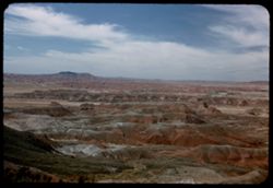
-
- Description:
- 50 f 5.6 Pola
- Subject:
- Deserts, Valleys, Hills, Painted Desert (Ariz.), Shrubs, Mesas, and Harvey Inn (Holbrook, Ariz.)
- Series:
- 17-52
- Creator:
- Cushman, Charles W., 1896-1972
- Date Created:
- 1952-04-12
- Genre:
- Landscape photographs
- Frame Number:
- 8
- County:
- Navajo and Coconimo
- Abstract:
- View north from near Fred Harvey Inn
- Call Number:
- P06101
- City:
- Holbrook
- Country:
- United States
- State/Province:
- Arizona
- Alternate Identifier:
- 1752.8
- Persistent URL:
- http://purl.dlib.indiana.edu/iudl/archives/cushman/P06101
- Holding Location:
- Bloomington - University Archives
Wells Library E460
1320 E 10th St.
Bloomington, IN 47405
Contact at archives@indiana.edu, 812-855-1127
-
- Description:
- 50 f 11
- Subject:
- Deserts, Canyons, Buildings, Clouds, Hills, Painted Desert (Ariz.), and Valleys
- Series:
- 17-52
- Creator:
- Cushman, Charles W., 1896-1972
- Date Created:
- 1952-04-12
- Genre:
- Landscape photographs
- Frame Number:
- 6
- County:
- Navajo and Coconimo
- Abstract:
- View east from inside
- Call Number:
- P06100
- City:
- Holbrook
- Country:
- United States
- State/Province:
- Arizona
- Physical Description:
- Image was originally mounted in a glass enclosure. Before digitization, the image was removed and placed in a Wess Plastic, Inc. brand, 2" x 2", pl...
- Alternate Identifier:
- 1752.6
- Persistent URL:
- http://purl.dlib.indiana.edu/iudl/archives/cushman/P06100
- Holding Location:
- Bloomington - University Archives
Wells Library E460
1320 E 10th St.
Bloomington, IN 47405
Contact at archives@indiana.edu, 812-855-1127
-
- Description:
- 50 f 6.3 Pola
- Subject:
- Deserts, Valleys, Mesas, Mountains, Shrubs, Hills, and Painted Desert (Ariz.)
- Series:
- 17-52
- Creator:
- Cushman, Charles W., 1896-1972
- Date Created:
- 1952-04-12
- Genre:
- Landscape photographs
- Frame Number:
- 5
- Street Address:
- United States Highway 66
- County:
- Navajo and Coconimo
- Abstract:
- Same
- Call Number:
- P06099
- City:
- Holbrook
- Country:
- United States
- State/Province:
- Arizona
- Alternate Identifier:
- 1752.5
- Persistent URL:
- http://purl.dlib.indiana.edu/iudl/archives/cushman/P06099
- Holding Location:
- Bloomington - University Archives
Wells Library E460
1320 E 10th St.
Bloomington, IN 47405
Contact at archives@indiana.edu, 812-855-1127
-
- Description:
- 50 f 6.3 Pola
- Subject:
- Deserts, Hills, Cliffs, Mountains, Mesas, and Painted Desert (Ariz.)
- Series:
- 17-52
- Creator:
- Cushman, Charles W., 1896-1972
- Date Created:
- 1952-04-12
- Genre:
- Landscape photographs
- Frame Number:
- 3
- County:
- Navajo and Coconimo
- Call Number:
- P06097
- City:
- Holbrook
- Country:
- United States
- State/Province:
- Arizona
- Physical Description:
- Image was originally mounted in a glass enclosure. Before digitization, the image was removed and placed in a Wess Plastic, Inc. brand, 2" x 2", pl...
- Alternate Identifier:
- 1752.3
- Persistent URL:
- http://purl.dlib.indiana.edu/iudl/archives/cushman/P06097
- Holding Location:
- Bloomington - University Archives
Wells Library E460
1320 E 10th St.
Bloomington, IN 47405
Contact at archives@indiana.edu, 812-855-1127
-
- Description:
- 50 f 6.3 Pola
- Subject:
- Deserts, Canyons, Trees, Shrubs, Hills, Painted Desert (Ariz.), and Valleys
- Series:
- 17-52
- Creator:
- Cushman, Charles W., 1896-1972
- Date Created:
- 1952-04-12
- Genre:
- Landscape photographs
- Frame Number:
- 4
- County:
- Navajo and Coconimo
- Abstract:
- Same
- Call Number:
- P06098
- City:
- Holbrook
- Country:
- United States
- State/Province:
- Arizona
- Alternate Identifier:
- 1752.4
- Persistent URL:
- http://purl.dlib.indiana.edu/iudl/archives/cushman/P06098
- Holding Location:
- Bloomington - University Archives
Wells Library E460
1320 E 10th St.
Bloomington, IN 47405
Contact at archives@indiana.edu, 812-855-1127
-
- Description:
- 50 f 6 Pola
- Subject:
- Deserts, Hills, Cliffs, Mountains, Mesas, and Painted Desert (Ariz.)
- Series:
- 17-52
- Creator:
- Cushman, Charles W., 1896-1972
- Date Created:
- 1952-04-12
- Genre:
- Landscape photographs
- Frame Number:
- 2
- County:
- Navajo and Coconimo
- Call Number:
- P06096
- City:
- Holbrook
- Country:
- United States
- State/Province:
- Arizona
- Alternate Identifier:
- 1752.2
- Persistent URL:
- http://purl.dlib.indiana.edu/iudl/archives/cushman/P06096
- Holding Location:
- Bloomington - University Archives
Wells Library E460
1320 E 10th St.
Bloomington, IN 47405
Contact at archives@indiana.edu, 812-855-1127
-
- Description:
- 25 f 8
- Subject:
- Wildflowers, Mead, Lake (Ariz. and Nev.), Mountains, Rock formations, Clouds, Hills, Deserts, Pyramidal mountain, and Shrubs
- Series:
- 15-52
- Creator:
- Cushman, Charles W., 1896-1972
- Date Created:
- 1952-04-10
- Genre:
- Landscape photographs
- Frame Number:
- 41
- County:
- Clark
- Abstract:
- Yellow desert flowers + pyramidal mtn. near Lake Mead.
- Call Number:
- P06060
- Country:
- United States
- State/Province:
- Nevada
- Alternate Identifier:
- 1542.41
- Persistent URL:
- http://purl.dlib.indiana.edu/iudl/archives/cushman/P06060
- Holding Location:
- Bloomington - University Archives
Wells Library E460
1320 E 10th St.
Bloomington, IN 47405
Contact at archives@indiana.edu, 812-855-1127
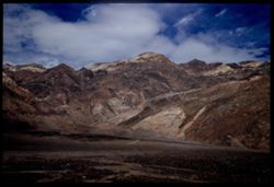
-
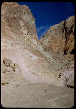
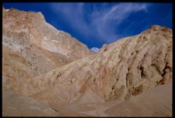
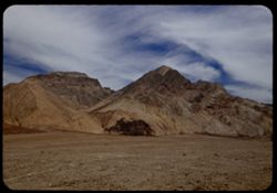
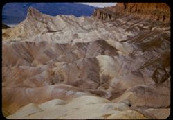
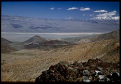
- Description:
- 25 f 16
- Subject:
- Deserts, Valleys, Cliffs, Shadows, Mountains, Rock formations, Death Valley (Calif. and Nev.), and Hills
- Series:
- 15-52
- Creator:
- Cushman, Charles W., 1896-1972
- Date Created:
- 1952-04-09
- Genre:
- Landscape photographs
- Frame Number:
- 39
- Street Address:
- Artists Drive
- Abstract:
- From top of Artists Drive. Kaleidoscopic view.
- Call Number:
- P06058
- Country:
- United States
- State/Province:
- California
- Physical Description:
- Image was originally mounted in a glass enclosure. Before digitization, the image was removed and placed in a Wess Plastic, Inc. brand, 2" x 2", pl...
- Alternate Identifier:
- 1552.39
- Persistent URL:
- http://purl.dlib.indiana.edu/iudl/archives/cushman/P06058
- Holding Location:
- Bloomington - University Archives
Wells Library E460
1320 E 10th St.
Bloomington, IN 47405
Contact at archives@indiana.edu, 812-855-1127
-

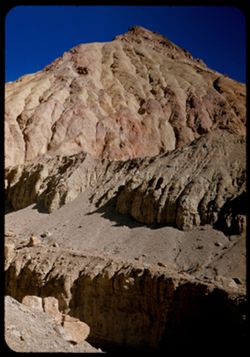
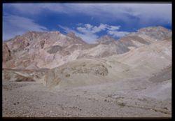
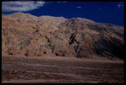
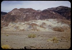
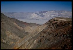
- Description:
- 25 f 13
- Subject:
- Rocks, Colored mountains, Valleys, Cliffs, Mountains, Rock formations, Death Valley (Calif. and Nev.), Deserts, and Hills
- Series:
- 15-52
- Creator:
- Cushman, Charles W., 1896-1972
- Date Created:
- 1952-04-09
- Genre:
- Landscape photographs
- Frame Number:
- 38
- Street Address:
- Artists Drive
- County:
- Inyo
- Abstract:
- From top of Artists Drive. Off Artists Drive.
- Call Number:
- P06057
- Country:
- United States
- State/Province:
- California
- Alternate Identifier:
- 1552.38
- Persistent URL:
- http://purl.dlib.indiana.edu/iudl/archives/cushman/P06057
- Holding Location:
- Bloomington - University Archives
Wells Library E460
1320 E 10th St.
Bloomington, IN 47405
Contact at archives@indiana.edu, 812-855-1127
-
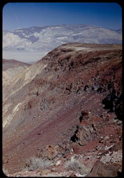
- Description:
- 25 f 16
- Subject:
- Rocks, Valleys, Cliffs, Boulders, Mountains, Death Valley (Calif. and Nev.), and Deserts
- Series:
- 15-52
- Creator:
- Cushman, Charles W., 1896-1972
- Date Created:
- 1952-04-09
- Genre:
- Landscape photographs
- Frame Number:
- 37
- Street Address:
- Artists Drive
- County:
- Inyo
- Abstract:
- From top of Artists Drive. Up from Artists Dr.
- Call Number:
- P06056
- Country:
- United States
- State/Province:
- California
- Alternate Identifier:
- 1552.37
- Persistent URL:
- http://purl.dlib.indiana.edu/iudl/archives/cushman/P06056
- Holding Location:
- Bloomington - University Archives
Wells Library E460
1320 E 10th St.
Bloomington, IN 47405
Contact at archives@indiana.edu, 812-855-1127
-
- Description:
- 25 f 16
- Subject:
- Deserts, Valleys, Cliffs, Mountains, Rock formations, and Death Valley (Calif. and Nev.)
- Series:
- 15-52
- Creator:
- Cushman, Charles W., 1896-1972
- Date Created:
- 1952-04-09
- Genre:
- Snapshots
- Frame Number:
- 36
- Street Address:
- Artists Drive
- County:
- Inyo
- Abstract:
- From top of Artists Drive. Up from Artists Dr.
- Call Number:
- P06055
- Country:
- United States
- State/Province:
- California
- Alternate Identifier:
- 1552.36
- Persistent URL:
- http://purl.dlib.indiana.edu/iudl/archives/cushman/P06055
- Holding Location:
- Bloomington - University Archives
Wells Library E460
1320 E 10th St.
Bloomington, IN 47405
Contact at archives@indiana.edu, 812-855-1127
-
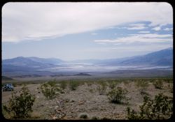
- Description:
- 25 f 8 Pola
- Subject:
- Deserts, Valleys, Hills, Death Valley (Calif. and Nev.), Mountains, Rocks, and Clouds
- Series:
- 15-52
- Creator:
- Cushman, Charles W., 1896-1972
- Date Created:
- 1952-04-09
- Genre:
- Landscape photographs
- Frame Number:
- 35
- Street Address:
- Artists Drive
- County:
- Inyo
- Abstract:
- From top of Artists Drive. Back across valley.
- Call Number:
- P06054
- Country:
- United States
- State/Province:
- California
- Alternate Identifier:
- 1552.35
- Persistent URL:
- http://purl.dlib.indiana.edu/iudl/archives/cushman/P06054
- Holding Location:
- Bloomington - University Archives
Wells Library E460
1320 E 10th St.
Bloomington, IN 47405
Contact at archives@indiana.edu, 812-855-1127
-
- Description:
- 25 f 13
- Subject:
- Rocks, Colored mountains, Valleys, Cliffs, Boulders, Mountains, Rock formations, Death Valley (Calif. and Nev.), Deserts, and Hills
- Series:
- 15-52
- Creator:
- Cushman, Charles W., 1896-1972
- Date Created:
- 1952-04-09
- Genre:
- Landscape photographs
- Frame Number:
- 33
- Street Address:
- Artists Drive
- County:
- Inyo
- Abstract:
- Colored mtns from Artists Drive.
- Call Number:
- P06052
- Country:
- United States
- State/Province:
- California
- Physical Description:
- Image was originally mounted in a glass enclosure. Before digitization, the image was removed and placed in a Wess Plastic, Inc. brand, 2" x 2", pl...
- Alternate Identifier:
- 1552.33
- Persistent URL:
- http://purl.dlib.indiana.edu/iudl/archives/cushman/P06052
- Holding Location:
- Bloomington - University Archives
Wells Library E460
1320 E 10th St.
Bloomington, IN 47405
Contact at archives@indiana.edu, 812-855-1127
-
- Description:
- 25 f 16
- Subject:
- Deserts, Valleys, Cliffs, Mountains, Hills, and Death Valley (Calif. and Nev.)
- Series:
- 15-52
- Creator:
- Cushman, Charles W., 1896-1972
- Date Created:
- 1952-04-09
- Genre:
- Landscape photographs
- Frame Number:
- 34
- Street Address:
- Artists Drive
- County:
- Inyo
- Abstract:
- From top of Artists Drive. Up.
- Call Number:
- P06053
- Country:
- United States
- State/Province:
- California
- Physical Description:
- Image was originally mounted in a glass enclosure. Before digitization, the image was removed and placed in a Wess Plastic, Inc. brand, 2" x 2", pl...
- Alternate Identifier:
- 1552.34
- Persistent URL:
- http://purl.dlib.indiana.edu/iudl/archives/cushman/P06053
- Holding Location:
- Bloomington - University Archives
Wells Library E460
1320 E 10th St.
Bloomington, IN 47405
Contact at archives@indiana.edu, 812-855-1127
-
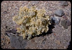
- Description:
- 25 f 16
- Subject:
- Valleys, Rocks, Death Valley (Calif. and Nev.), Deserts, and Shrubs
- Series:
- 15-52
- Creator:
- Cushman, Charles W., 1896-1972
- Date Created:
- 1952-04-09
- Genre:
- Identification photographs
- Frame Number:
- 32
- County:
- Inyo
- Abstract:
- Desert holly.
- Call Number:
- P06051
- Country:
- United States
- State/Province:
- California
- Alternate Identifier:
- 1552.32
- Persistent URL:
- http://purl.dlib.indiana.edu/iudl/archives/cushman/P06051
- Holding Location:
- Bloomington - University Archives
Wells Library E460
1320 E 10th St.
Bloomington, IN 47405
Contact at archives@indiana.edu, 812-855-1127
-
- Description:
- 25 f 13
- Subject:
- Deserts, Valleys, Mountains, Hills, Rocks, and Death Valley (Calif. and Nev.)
- Series:
- 15-52
- Creator:
- Cushman, Charles W., 1896-1972
- Date Created:
- 1952-04-09
- Genre:
- Landscape photographs
- Frame Number:
- 31
- Street Address:
- Artists Drive
- County:
- Inyo
- Abstract:
- Mtns from Atrists Drive.
- Call Number:
- P06050
- Country:
- United States
- State/Province:
- California
- Physical Description:
- Image was originally mounted in a glass enclosure. Before digitization, the image was removed and placed in a Wess Plastic, Inc. brand, 2" x 2", pl...
- Alternate Identifier:
- 1552.31
- Persistent URL:
- http://purl.dlib.indiana.edu/iudl/archives/cushman/P06050
- Holding Location:
- Bloomington - University Archives
Wells Library E460
1320 E 10th St.
Bloomington, IN 47405
Contact at archives@indiana.edu, 812-855-1127
-
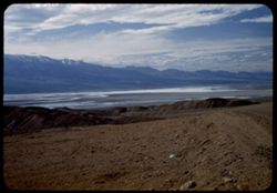
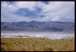
- Description:
- 25 f 9 Pola
- Subject:
- Lakes & ponds, Deserts, Valleys, Death Valley (Calif. and Nev.), Roads, Cliffs, Mountains, Boulders, and Rocks
- Series:
- 15-52
- Creator:
- Cushman, Charles W., 1896-1972
- Date Created:
- 1952-04-09
- Genre:
- Snapshots
- Frame Number:
- 29
- County:
- Inyo
- Abstract:
- Mtns at Bad Water, 279.6 ft. below
- Call Number:
- P06049
- City:
- Badwater
- Country:
- United States
- State/Province:
- California
- Alternate Identifier:
- 1552.29
- Persistent URL:
- http://purl.dlib.indiana.edu/iudl/archives/cushman/P06049
- Holding Location:
- Bloomington - University Archives
Wells Library E460
1320 E 10th St.
Bloomington, IN 47405
Contact at archives@indiana.edu, 812-855-1127
-
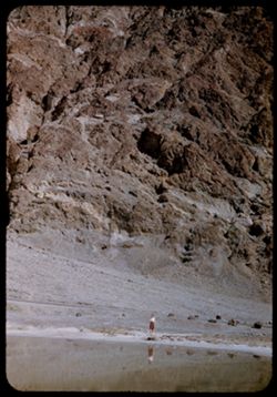
- Description:
- 25 f 13
- Subject:
- Lakes & ponds, Deserts, Reflections, Valleys, Death Valley (Calif. and Nev.), Roads, Cliffs, Mountains, Women, Boulders, and Rocks
- Series:
- 15-52
- Creator:
- Cushman, Charles W., 1896-1972
- Date Created:
- 1952-04-09
- Genre:
- Portraits and Snapshots
- Frame Number:
- 28
- County:
- Inyo
- Persons Pictured:
- Cushman, Jean
- Abstract:
- Mtns at Bad Water, 279.6 ft. below.
- Call Number:
- P06048
- City:
- Badwater
- Country:
- United States
- State/Province:
- California
- Alternate Identifier:
- 1552.28
- Persistent URL:
- http://purl.dlib.indiana.edu/iudl/archives/cushman/P06048
- Holding Location:
- Bloomington - University Archives
Wells Library E460
1320 E 10th St.
Bloomington, IN 47405
Contact at archives@indiana.edu, 812-855-1127
-
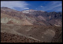
- Description:
- 25 f 11 Pola
- Subject:
- Deserts, Amargosa Range (Nev. and Calif.), Valleys, Death Valley (Calif. and Nev.), Mountains, and Rocks
- Series:
- 15-52
- Creator:
- Cushman, Charles W., 1896-1972
- Date Created:
- 1952-04-09
- Genre:
- Landscape photographs
- Frame Number:
- 27
- County:
- Inyo
- Abstract:
- Amargosa Mtns near Bad Water.
- Call Number:
- P06047
- City:
- Badwater
- Country:
- United States
- State/Province:
- California
- Physical Description:
- Image was originally mounted in a glass enclosure. Before digitization, the image was removed and placed in a Wess Plastic, Inc. brand, 2" x 2", pl...
- Alternate Identifier:
- 1552.27
- Persistent URL:
- http://purl.dlib.indiana.edu/iudl/archives/cushman/P06047
- Holding Location:
- Bloomington - University Archives
Wells Library E460
1320 E 10th St.
Bloomington, IN 47405
Contact at archives@indiana.edu, 812-855-1127
-
- Description:
- 25 f 9 Pola
- Subject:
- Deserts, Valleys, Mountains, Death Valley (Calif. and Nev.), Amargosa Range (Nev. and Calif.), and Rocks
- Series:
- 15-52
- Creator:
- Cushman, Charles W., 1896-1972
- Date Created:
- 1952-04-09
- Genre:
- Landscape photographs
- Frame Number:
- 26
- County:
- Inyo
- Abstract:
- Amargosa Mtns near Bad Water.
- Call Number:
- P06046
- City:
- Badwater
- Country:
- United States
- State/Province:
- California
- Physical Description:
- Image was originally mounted in a glass enclosure. Before digitization, the image was removed and placed in a Wess Plastic, Inc. brand, 2" x 2", pl...
- Alternate Identifier:
- 1552.26
- Persistent URL:
- http://purl.dlib.indiana.edu/iudl/archives/cushman/P06046
- Holding Location:
- Bloomington - University Archives
Wells Library E460
1320 E 10th St.
Bloomington, IN 47405
Contact at archives@indiana.edu, 812-855-1127
-
- Description:
- 25 f 8 Pola
- Subject:
- Bodies of water, Telescope Peak (Inyo County, Calif.), Hills, Mountains, Death Valley (Calif. and Nev.), Deserts, Shrubs, Valleys, and Snow
- Series:
- 15-52
- Creator:
- Cushman, Charles W., 1896-1972
- Date Created:
- 1952-04-09
- Genre:
- Landscape photographs
- Frame Number:
- 25
- County:
- Inyo
- Abstract:
- Telescope Pk. from Bad Water. 280 ft. below sea level.
- Call Number:
- P06045
- City:
- Badwater
- Country:
- United States
- State/Province:
- California
- Physical Description:
- Image was originally mounted in a glass enclosure. Before digitization, the image was removed and placed in a Wess Plastic, Inc. brand, 2" x 2", pl...
- Alternate Identifier:
- 1552.25
- Persistent URL:
- http://purl.dlib.indiana.edu/iudl/archives/cushman/P06045
- Holding Location:
- Bloomington - University Archives
Wells Library E460
1320 E 10th St.
Bloomington, IN 47405
Contact at archives@indiana.edu, 812-855-1127
-
- Description:
- 25 f 9 Pola
- Subject:
- Deserts, Valleys, Salt pools, Mountains, Shrubs, Hills, Black Mountains (Inyo County, Calif.), Rocks, and Death Valley (Calif. and Nev.)
- Series:
- 15-52
- Creator:
- Cushman, Charles W., 1896-1972
- Date Created:
- 1952-04-09
- Genre:
- Landscape photographs
- Frame Number:
- 24
- County:
- Inyo
- Abstract:
- Colored Mtns. The Black Mtns - near Salt Pools this time.
- Call Number:
- P06044
- Country:
- United States
- State/Province:
- California
- Alternate Identifier:
- 1552.24
- Persistent URL:
- http://purl.dlib.indiana.edu/iudl/archives/cushman/P06044
- Holding Location:
- Bloomington - University Archives
Wells Library E460
1320 E 10th St.
Bloomington, IN 47405
Contact at archives@indiana.edu, 812-855-1127
-

- Description:
- 25 f 9 Pola
- Subject:
- Deserts, Valleys, Hills, Death Valley (Calif. and Nev.), Mountains, Colored mountains, Rocks, Rock formations, and Black Mountains (Inyo County, Calif.)
- Series:
- 15-52
- Creator:
- Cushman, Charles W., 1896-1972
- Date Created:
- 1952-04-09
- Genre:
- Landscape photographs
- Frame Number:
- 23
- County:
- Inyo
- Abstract:
- Colored Mtns. The Black Mtns.
- Call Number:
- P06043
- Country:
- United States
- State/Province:
- California
- Alternate Identifier:
- 1552.23
- Persistent URL:
- http://purl.dlib.indiana.edu/iudl/archives/cushman/P06043
- Holding Location:
- Bloomington - University Archives
Wells Library E460
1320 E 10th St.
Bloomington, IN 47405
Contact at archives@indiana.edu, 812-855-1127
-
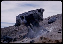
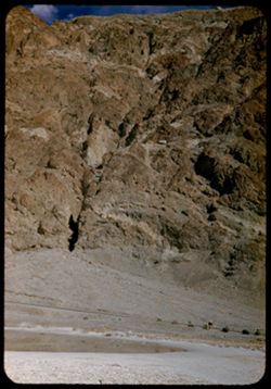
- Description:
- 25 f 10
- Subject:
- Deserts, Mushroom Rock (Inyo County, Calif.), Boulders, Rock formations, Hills, Rocks, Valleys, and Death Valley (Calif. and Nev.)
- Series:
- 15-52
- Creator:
- Cushman, Charles W., 1896-1972
- Date Created:
- 1952-04-09
- Genre:
- Snapshots
- Frame Number:
- 22
- County:
- Inyo
- Abstract:
- Mushroom rock.
- Call Number:
- P06042
- City:
- Furnace Creek
- Country:
- United States
- State/Province:
- California
- Alternate Identifier:
- 1552.22
- Persistent URL:
- http://purl.dlib.indiana.edu/iudl/archives/cushman/P06042
- Holding Location:
- Bloomington - University Archives
Wells Library E460
1320 E 10th St.
Bloomington, IN 47405
Contact at archives@indiana.edu, 812-855-1127
-

- Description:
- 25 f 14
- Subject:
- Deserts, Amargosa Range (Nev. and Calif.), Valleys, Hills, Death Valley (Calif. and Nev.), Cliffs, Mountains, Shrubs, Rocks, Canyons, and Desolation Canyon (...
- Series:
- 15-52
- Creator:
- Cushman, Charles W., 1896-1972
- Date Created:
- 1952-04-09
- Genre:
- Landscape photographs
- Frame Number:
- 21
- Street Address:
- Bad Water Road
- County:
- Inyo
- Abstract:
- Approx. same.
- Call Number:
- P06041
- City:
- Furnace Creek
- Country:
- United States
- State/Province:
- California
- Alternate Identifier:
- 1552.21
- Persistent URL:
- http://purl.dlib.indiana.edu/iudl/archives/cushman/P06041
- Holding Location:
- Bloomington - University Archives
Wells Library E460
1320 E 10th St.
Bloomington, IN 47405
Contact at archives@indiana.edu, 812-855-1127
-
- Description:
- 25 f 9 Pola
- Subject:
- Deserts, Valleys, Mountains, Death Valley (Calif. and Nev.), Canyons, Hills, and Desolation Canyon (Calif.)
- Series:
- 15-52
- Creator:
- Cushman, Charles W., 1896-1972
- Date Created:
- 1952-04-09
- Genre:
- Landscape photographs
- Frame Number:
- 20
- County:
- Inyo
- Abstract:
- From road to Bad Water toward Desolation Canyon.
- Call Number:
- P06040
- City:
- Furnace Creek and Badwater
- Country:
- United States
- State/Province:
- California
- Alternate Identifier:
- 1552.20
- Persistent URL:
- http://purl.dlib.indiana.edu/iudl/archives/cushman/P06040
- Holding Location:
- Bloomington - University Archives
Wells Library E460
1320 E 10th St.
Bloomington, IN 47405
Contact at archives@indiana.edu, 812-855-1127
-
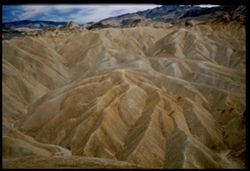
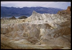
- Description:
- 25 f 11 Pola
- Subject:
- Deserts, Valleys, Mountains, Rock formations, Zabriskie Point (Calif.), and Death Valley (Calif. and Nev.)
- Series:
- 15-52
- Creator:
- Cushman, Charles W., 1896-1972
- Date Created:
- 1952-04-09
- Genre:
- Landscape photographs
- Frame Number:
- 19
- County:
- Inyo
- Abstract:
- East + down from Zab. Pt.
- Call Number:
- P06039
- City:
- Furnace Creek
- Country:
- United States
- State/Province:
- California
- Physical Description:
- Image was originally mounted in a glass enclosure. Before digitization, the image was removed and placed in a Wess Plastic, Inc. brand, 2" x 2", pl...
- Alternate Identifier:
- 1552.19
- Persistent URL:
- http://purl.dlib.indiana.edu/iudl/archives/cushman/P06039
- Holding Location:
- Bloomington - University Archives
Wells Library E460
1320 E 10th St.
Bloomington, IN 47405
Contact at archives@indiana.edu, 812-855-1127
-
- Description:
- 25 f 9 Pola
- Subject:
- Deserts, Valleys, Mountains, Rock formations, Zabriskie Point (Calif.), and Death Valley (Calif. and Nev.)
- Series:
- 15-52
- Creator:
- Cushman, Charles W., 1896-1972
- Date Created:
- 1952-04-09
- Genre:
- Landscape photographs
- Frame Number:
- 18
- County:
- Inyo
- Abstract:
- NW from out on shoulder.
- Call Number:
- P06038
- City:
- Furnace Creek
- Country:
- United States
- State/Province:
- California
- Alternate Identifier:
- 1552.18
- Persistent URL:
- http://purl.dlib.indiana.edu/iudl/archives/cushman/P06038
- Holding Location:
- Bloomington - University Archives
Wells Library E460
1320 E 10th St.
Bloomington, IN 47405
Contact at archives@indiana.edu, 812-855-1127
-
- Description:
- 25 f 8 Pola
- Subject:
- Deserts, Valleys, Cliffs, Mountains, Rock formations, Zabriskie Point (Calif.), and Death Valley (Calif. and Nev.)
- Series:
- 15-52
- Creator:
- Cushman, Charles W., 1896-1972
- Date Created:
- 1952-04-09
- Genre:
- Landscape photographs
- Frame Number:
- 17
- County:
- Inyo
- Abstract:
- West from north of Pt.
- Call Number:
- P06037
- City:
- Furnace Creek
- Country:
- United States
- State/Province:
- California
- Physical Description:
- Image was originally mounted in a glass enclosure. Before digitization, the image was removed and placed in a Wess Plastic, Inc. brand, 2" x 2", pl...
- Alternate Identifier:
- 1552.17
- Persistent URL:
- http://purl.dlib.indiana.edu/iudl/archives/cushman/P06037
- Holding Location:
- Bloomington - University Archives
Wells Library E460
1320 E 10th St.
Bloomington, IN 47405
Contact at archives@indiana.edu, 812-855-1127
-
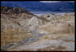
- Description:
- 25 f 9 Pola
- Subject:
- Deserts, Valleys, Cliffs, Mountains, Zabriskie Point (Calif.), Death Valley (Calif. and Nev.), Streams, and Hills
- Series:
- 15-52
- Creator:
- Cushman, Charles W., 1896-1972
- Date Created:
- 1952-04-09
- Genre:
- Landscape photographs
- Frame Number:
- 16
- County:
- Inyo
- Abstract:
- West from Zabriskie Pt.
- Call Number:
- P06036
- City:
- Furnace Creek
- Country:
- United States
- State/Province:
- California
- Physical Description:
- Image was originally mounted in a glass enclosure. Before digitization, the image was removed and placed in a Wess Plastic, Inc. brand, 2" x 2", pl...
- Alternate Identifier:
- 1552.16
- Persistent URL:
- http://purl.dlib.indiana.edu/iudl/archives/cushman/P06036
- Holding Location:
- Bloomington - University Archives
Wells Library E460
1320 E 10th St.
Bloomington, IN 47405
Contact at archives@indiana.edu, 812-855-1127
-
- Description:
- 25 f 8 Pola
- Subject:
- Deserts, Valleys, Mountains, Shrubs, and Death Valley (Calif. and Nev.)
- Series:
- 15-52
- Creator:
- Cushman, Charles W., 1896-1972
- Date Created:
- 1952-04-09
- Genre:
- Landscape photographs
- Frame Number:
- 13
- County:
- Inyo
- Abstract:
- View WSW across valley.
- Call Number:
- P06034
- Country:
- United States
- State/Province:
- California
- Physical Description:
- Image was originally mounted in a glass enclosure. Before digitization, the image was removed and placed in a Wess Plastic, Inc. brand, 2" x 2", pl...
- Alternate Identifier:
- 1552.13
- Persistent URL:
- http://purl.dlib.indiana.edu/iudl/archives/cushman/P06034
- Holding Location:
- Bloomington - University Archives
Wells Library E460
1320 E 10th St.
Bloomington, IN 47405
Contact at archives@indiana.edu, 812-855-1127
-
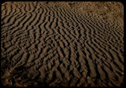
- Description:
- 25 f 8 Pola
- Subject:
- Deserts, Ripples, Valleys, Sand, Dunes, and Death Valley (Calif. and Nev.)
- Series:
- 15-52
- Creator:
- Cushman, Charles W., 1896-1972
- Date Created:
- 1952-04-08
- Genre:
- Snapshots
- Frame Number:
- 11
- County:
- Inyo
- Abstract:
- Sand ripples.
- Call Number:
- P06032
- City:
- Stovepipe Wells
- Country:
- United States
- State/Province:
- California
- Alternate Identifier:
- 1552.11
- Persistent URL:
- http://purl.dlib.indiana.edu/iudl/archives/cushman/P06032
- Holding Location:
- Bloomington - University Archives
Wells Library E460
1320 E 10th St.
Bloomington, IN 47405
Contact at archives@indiana.edu, 812-855-1127
-
- Description:
- 25 f 6.3 Pola
- Subject:
- Deserts, Valleys, Hills, Automobiles, Death Valley (Calif. and Nev.), Roads, Mountains, Shrubs, and Rocks
- Series:
- 15-52
- Creator:
- Cushman, Charles W., 1896-1972
- Date Created:
- 1952-04-09
- Genre:
- Landscape photographs
- Frame Number:
- 12
- County:
- Inyo
- Abstract:
- Death Valley from north.
- Call Number:
- P06033
- City:
- Beatty Junction
- Country:
- United States
- State/Province:
- California
- Alternate Identifier:
- 1552.12
- Persistent URL:
- http://purl.dlib.indiana.edu/iudl/archives/cushman/P06033
- Holding Location:
- Bloomington - University Archives
Wells Library E460
1320 E 10th St.
Bloomington, IN 47405
Contact at archives@indiana.edu, 812-855-1127
-
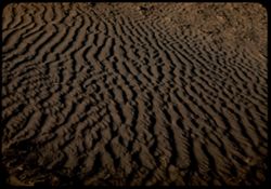
- Description:
- 25 f 8 Pola (with screen turned)
- Subject:
- Deserts, Ripples, Valleys, Sand, Dunes, and Death Valley (Calif. and Nev.)
- Series:
- 15-52
- Creator:
- Cushman, Charles W., 1896-1972
- Date Created:
- 1952-04-08
- Genre:
- Snapshots
- Frame Number:
- 10
- County:
- Inyo
- Abstract:
- Sand ripples.
- Call Number:
- P06031
- City:
- Stovepipe Wells
- Country:
- United States
- State/Province:
- California
- Alternate Identifier:
- 1552.10
- Persistent URL:
- http://purl.dlib.indiana.edu/iudl/archives/cushman/P06031
- Holding Location:
- Bloomington - University Archives
Wells Library E460
1320 E 10th St.
Bloomington, IN 47405
Contact at archives@indiana.edu, 812-855-1127
-
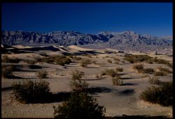
- Description:
- 25 f 8 Pola
- Subject:
- Deserts, Valleys, Sand, Dunes, Mountains, Shrubs, and Death Valley (Calif. and Nev.)
- Series:
- 15-52
- Creator:
- Cushman, Charles W., 1896-1972
- Date Created:
- 1952-04-01
- Genre:
- Landscape photographs
- Frame Number:
- 9
- County:
- Inyo
- Abstract:
- Sand Dunes near Stovepipe Wells.
- Call Number:
- P06030
- City:
- Stovepipe Wells
- Country:
- United States
- State/Province:
- California
- Physical Description:
- Image was originally mounted in a glass enclosure. Before digitization, the image was removed and placed in a Wess Plastic, Inc. brand, 2" x 2", pl...
- Alternate Identifier:
- 1552.9
- Persistent URL:
- http://purl.dlib.indiana.edu/iudl/archives/cushman/P06030
- Holding Location:
- Bloomington - University Archives
Wells Library E460
1320 E 10th St.
Bloomington, IN 47405
Contact at archives@indiana.edu, 812-855-1127
-
- Description:
- 25 f 8 Pola
- Subject:
- Deserts, Valleys, Roads, Mountains, Shrubs, Panamint Valley (Calif.), Hills, Rocks, Panamint Range (Calif.), and Death Valley (Calif. and Nev.)
- Series:
- 15-52
- Creator:
- Cushman, Charles W., 1896-1972
- Date Created:
- 1952-04-08
- Genre:
- Landscape photographs
- Frame Number:
- 6
- County:
- Inyo
- Abstract:
- Road is straight across Panamint Valley.
- Call Number:
- P06027
- Country:
- United States
- State/Province:
- California
- Physical Description:
- Image was originally mounted in a glass enclosure. Before digitization, the image was removed and placed in a Wess Plastic, Inc. brand, 2" x 2", pl...
- Alternate Identifier:
- 1552.6
- Persistent URL:
- http://purl.dlib.indiana.edu/iudl/archives/cushman/P06027
- Holding Location:
- Bloomington - University Archives
Wells Library E460
1320 E 10th St.
Bloomington, IN 47405
Contact at archives@indiana.edu, 812-855-1127
-
- Description:
- 25 f 9
- Subject:
- Panamint Mountains (Calif.), Deserts, Canyons, Valleys, Death Valley (Calif. and Nev.), Panamint Valley (Calif.), Mountains, Cliffs, and Panamint Range (Calif.)
- Series:
- 15-52
- Creator:
- Cushman, Charles W., 1896-1972
- Date Created:
- 1952-04-01
- Genre:
- Landscape photographs
- Frame Number:
- 3
- County:
- Inyo
- Abstract:
- Mouth of Canyon into Panamint Valley - Panamint Mtns in distance.
- Call Number:
- P06024
- Country:
- United States
- State/Province:
- California
- Physical Description:
- Image was originally mounted in a glass enclosure. Before digitization, the image was removed and placed in a Wess Plastic, Inc. brand, 2" x 2", pl...
- Alternate Identifier:
- 1552.3
- Persistent URL:
- http://purl.dlib.indiana.edu/iudl/archives/cushman/P06024
- Holding Location:
- Bloomington - University Archives
Wells Library E460
1320 E 10th St.
Bloomington, IN 47405
Contact at archives@indiana.edu, 812-855-1127
-
- Description:
- 25 f 8 Pola
- Subject:
- Deserts, Valleys, Panamint Range (Calif.), Panamint Mountains (Calif.), Argus Range (Calif.), Mountains, Shrubs, Panamint Valley (Calif.), Death Valley (Cali...
- Series:
- 15-52
- Creator:
- Cushman, Charles W., 1896-1972
- Date Created:
- 1952-04-08
- Genre:
- Landscape photographs
- Frame Number:
- 4
- County:
- Inyo
- Abstract:
- Same [P]
- Call Number:
- P06025
- Country:
- United States
- State/Province:
- California
- Alternate Identifier:
- 1552.4
- Persistent URL:
- http://purl.dlib.indiana.edu/iudl/archives/cushman/P06025
- Holding Location:
- Bloomington - University Archives
Wells Library E460
1320 E 10th St.
Bloomington, IN 47405
Contact at archives@indiana.edu, 812-855-1127