
Search Constraints
You searched for:
Campus
IUB
Remove constraint Campus: IUB
Pages
0-99 pages
Remove constraint Pages: 0-99 pages
Publisher
Генеральный штаб РККА
Remove constraint Publisher: Генеральный штаб РККА
Search Results
-
- Description:
- 1909
- Subject:
- Geographic Subject: Lutowiska, Topical Subject: Soviet Union, and Topical Subject: Maps
- Publisher:
- Генеральный штаб РККА
- Language:
- Russian
- Date Created:
- 1930
- Identifier:
- VAC9619-003030
- Genre:
- Military Maps and Topographic Maps
- Geographic Location:
- Coordinates: 49, 22.5, 49.333, 23
- Related URL:
- Catalog URL: https://iucat.iu.edu/catalog/5020129 and Download GeoTIFF: https://drive.google.com/file/d/1Krhy099-J2gYbPw-jiaJdVsFpUXCwMvQ/view?usp=sharing
- Abstract:
- Modern area represented: Lutowiska, Subcarpathian province, Poland
- Call Number:
- G7000 s100 .S7 sheet M-34-106
- City:
- Лютовиска (Lutowiska)
- Copyright Holder:
- No Copyright - United States
- Country:
- Чехословакия (Czechoslovakia) and Польша (Poland)
- Physical Description:
- Scale: 1:100,000
- Persistent URL:
- http://purl.dlib.indiana.edu/iudl/images/VAC9619/VAC9619-003030
- Provenance:
- CIA Map Library
-
- Description:
- 1918
- Subject:
- Geographic Subject: Wola Michowa, Topical Subject: Soviet Union, and Topical Subject: Maps
- Publisher:
- Генеральный штаб РККА
- Language:
- Russian
- Date Created:
- 1930
- Identifier:
- VAC9619-003029
- Genre:
- Military Maps and Topographic Maps
- Geographic Location:
- Coordinates: 49, 22, 49.333, 22.5
- Related URL:
- Catalog URL: https://iucat.iu.edu/catalog/5020129 and Download GeoTIFF: https://drive.google.com/file/d/1gIN67lRHUmXMAreXLfv0KuKc2MGQwhLr/view?usp=sharing
- Abstract:
- Modern area represented: Wola Michowa, Subcarpathian province, Poland
- Call Number:
- G7000 s100 .S7 sheet M-34-105
- City:
- Воля Михова (Wola Michowa)
- Copyright Holder:
- No Copyright - United States
- Country:
- Чехословакия (Czechoslovakia) and Польша (Poland)
- Physical Description:
- Scale: 1:100,000
- Persistent URL:
- http://purl.dlib.indiana.edu/iudl/images/VAC9619/VAC9619-003029
- Provenance:
- CIA Map Library
-
- Description:
- 1914
- Subject:
- Topical Subject: Maps, Geographic Subject: Stropkov, and Topical Subject: Soviet Union
- Publisher:
- Генеральный штаб РККА
- Language:
- Russian
- Date Created:
- 1931
- Identifier:
- VAC9619-003028
- Genre:
- Topographic Maps and Military Maps
- Geographic Location:
- Coordinates: 49, 21.5, 49.333, 22
- Related URL:
- Download GeoTIFF: https://drive.google.com/file/d/1M3V7zqjGz4gTyMHUtj66zDrUJfFp_mGi/view?usp=sharing and Catalog URL: https://iucat.iu.edu/catalog/5020129
- Abstract:
- Modern area represented: Stropkov, Prešov region, Slovakia
- Call Number:
- G7000 s100 .S7 sheet M-34-104
- City:
- Стропков (Stropkov)
- Copyright Holder:
- No Copyright - United States
- Country:
- Польша (Poland) and Чехословакия (Czechoslovakia)
- Physical Description:
- Scale: 1:100,000
- Persistent URL:
- http://purl.dlib.indiana.edu/iudl/images/VAC9619/VAC9619-003028
- Provenance:
- DMA Topographic Center, Army Map Service Library, OMAHA
-
- Description:
- 1940
- Subject:
- Geographic Subject: Olomouc, Topical Subject: Soviet Union, and Topical Subject: Maps
- Publisher:
- Генеральный штаб РККА
- Language:
- Russian
- Identifier:
- VAC9619-002713
- Genre:
- Military Maps and Topographic Maps
- Geographic Location:
- Coordinates: 49.333, 17, 49.667, 17.5
- Related URL:
- Download GeoTIFF: https://drive.google.com/file/d/1NC3fohsTd9_LWeg2NrbSuP02e53gW9ue/view?usp=sharing and Catalog URL: https://iucat.iu.edu/catalog/5020129
- Abstract:
- Modern area represented: Olomouc, Olomouc region, Czech Republic
- Call Number:
- G7000 s100 .S7 sheet M-33-95
- City:
- Оломоуц (Olomouc)
- Copyright Holder:
- No Copyright - United States
- Country:
- Германия (Germany)
- State/Province:
- Протекторат Богемии и Моравии (Protectorate of Bohemia and Moravia)
- Physical Description:
- Scale: 1:100,000
- Persistent URL:
- http://purl.dlib.indiana.edu/iudl/images/VAC9619/VAC9619-002713
- Provenance:
- DMA Topographic Center, Library of Congress Geography & Map Division, Army Map Service Library, OMAHA
-
- Description:
- 1940
- Subject:
- Geographic Subject: Malacky, Topical Subject: Maps, and Topical Subject: Soviet Union
- Publisher:
- Генеральный штаб РККА
- Language:
- Russian
- Identifier:
- VAC9619-002717
- Genre:
- Topographic Maps and Military Maps
- Geographic Location:
- Coordinates: 48.333, 17, 48.667, 17.5
- Related URL:
- Catalog URL: https://iucat.iu.edu/catalog/5020129 and Download GeoTIFF: https://drive.google.com/file/d/1Lk1U7dlD433a8rEUh8knFZx49I4F_AQR/view?usp=sharing
- Abstract:
- Modern area represented: Malacky, Záhorie region, Slovakia
- Call Number:
- G7000 s100 .S7 sheet M-33-131
- City:
- Малацки (Malacky)
- Copyright Holder:
- No Copyright - United States
- Country:
- Словакия (Slovakia)
- Physical Description:
- Scale: 1:100,000
- Persistent URL:
- http://purl.dlib.indiana.edu/iudl/images/VAC9619/VAC9619-002717
- Provenance:
- DMA Topographic Center, Library of Congress Geography & Map Division, Army Map Service Library, OMAHA
-
- Description:
- 1887
- Subject:
- Geographic Subject: Břeclav, Topical Subject: Maps, and Topical Subject: Soviet Union
- Publisher:
- Генеральный штаб РККА
- Language:
- Russian
- Date Created:
- 1940
- Identifier:
- VAC9619-002716
- Genre:
- Topographic Maps and Military Maps
- Geographic Location:
- Coordinates: 48.667, 16.5, 49, 17
- Related URL:
- Download GeoTIFF: https://drive.google.com/file/d/1Xz9QjEJFlda42zTIvCh3f9f004Vs9M1C/view?usp=sharing and Catalog URL: https://iucat.iu.edu/catalog/5020129
- Abstract:
- Modern area represented: Břeclav, South Moravian region, Czech Republic
- Call Number:
- G7000 s100 .S7 sheet M-33-118
- City:
- Бржеслав (Břeclav)
- Copyright Holder:
- No Copyright - United States
- Country:
- Словакия (Slovakia) and Германия (Germany)
- State/Province:
- Протекторат Богемии и Моравии (Protectorate of Bohemia and Moravia)
- Physical Description:
- Scale: 1:100,000
- Persistent URL:
- http://purl.dlib.indiana.edu/iudl/images/VAC9619/VAC9619-002716
- Provenance:
- DMA Topographic Center, Library of Congress Geography & Map Division, Army Map Service Library
-

- Description:
- 1932
- Subject:
- Topical Subject: Maps, Geographic Subject: Voznesenka, and Topical Subject: Soviet Union
- Publisher:
- Генеральный штаб РККА
- Language:
- Russian
- Date Created:
- 1937
- Identifier:
- VAC9619-002583
- Genre:
- Topographic Maps and Military Maps
- Geographic Location:
- Coordinates: 44, 132, 44.333, 132.5
- Related URL:
- Catalog URL: https://iucat.iu.edu/catalog/5020129 and Download GeoTIFF: https://drive.google.com/file/d/1BGYnRX3FLBO2XyU9bdVSRsYFZeZkZ3D3/view?usp=sharing
- Abstract:
- Modern area represented: Voznesenka, Primorskiy kray, Russia
- Call Number:
- G7000 s100 .S7 sheet L-53-133
- Caption:
- Не подлежит оглашению
- City:
- Вознесенское (Voznesenskoye)
- Copyright Holder:
- No Copyright - United States
- Country:
- СССР (USSR)
- State/Province:
- РСФСР (RSFSR), Дальневосточный край (Far Eastern kray), and Уссурийская область (Ussuriysk oblast)
- Physical Description:
- Scale: 1:100,000
- Persistent URL:
- http://purl.dlib.indiana.edu/iudl/images/VAC9619/VAC9619-002583
- Provenance:
- Army Map Service Library
-
- Description:
- 1932
- Subject:
- Geographic Subject: Khorol, Topical Subject: Maps, and Topical Subject: Soviet Union
- Publisher:
- Генеральный штаб РККА
- Language:
- Russian
- Date Created:
- 1937
- Identifier:
- VAC9619-002580
- Genre:
- Military Maps and Topographic Maps
- Geographic Location:
- Coordinates: 44.333, 132, 44.667, 132.5
- Related URL:
- Catalog URL: https://iucat.iu.edu/catalog/5020129 and Download GeoTIFF: https://drive.google.com/file/d/1f1acE_UwwKTVcp9HkXa-ZXvOjK6E2Mtl/view?usp=sharing
- Abstract:
- Modern area represented: Khorol, Primorskiy kray, Russia
- Call Number:
- G7000 s100 .S7 sheet L-53-121
- Caption:
- Не подлежит оглашению
- City:
- Хороль (Khorol)
- Copyright Holder:
- No Copyright - United States
- Country:
- СССР (USSR)
- State/Province:
- Дальневосточный край (Far Eastern kray), РСФСР (RSFSR), and Уссурийская область (Ussuriysk oblast)
- Physical Description:
- Scale: 1:100,000
- Persistent URL:
- http://purl.dlib.indiana.edu/iudl/images/VAC9619/VAC9619-002580
- Provenance:
- Army Map Service Library
-
- Description:
- 1932
- Subject:
- Topical Subject: Soviet Union, Topical Subject: Maps, and Geographic Subject: Galenki
- Publisher:
- Генеральный штаб РККА
- Language:
- Russian
- Date Created:
- 1937
- Identifier:
- VAC9619-002544
- Genre:
- Topographic Maps and Military Maps
- Geographic Location:
- Coordinates: 44, 131.5, 44.333, 132
- Related URL:
- Download GeoTIFF: https://drive.google.com/file/d/1LqMXpOS7gm8yXezvK9LLy78KeXJscvoC/view?usp=sharing and Catalog URL: https://iucat.iu.edu/catalog/5020129
- Abstract:
- Modern area represented: Galenki, Primorskiy kray, Russia
- Call Number:
- G7000 s100 .S7 sheet L-52-144
- Caption:
- Не подлежит оглашению
- City:
- Галенки (Galenki)
- Copyright Holder:
- No Copyright - United States
- Country:
- СССР (USSR)
- State/Province:
- РСФСР (RSFSR) and Уссурийская область (Ussuriysk oblast)
- Physical Description:
- Scale: 1:100,000
- Persistent URL:
- http://purl.dlib.indiana.edu/iudl/images/VAC9619/VAC9619-002544
- Provenance:
- DMA Topographic Center, Army Map Service Library
-
- Description:
- 1932
- Subject:
- Geographic Subject: Zharikovo, Topical Subject: Maps, and Topical Subject: Soviet Union
- Publisher:
- Генеральный штаб РККА
- Language:
- Russian
- Date Created:
- 1937
- Identifier:
- VAC9619-002543
- Genre:
- Topographic Maps and Military Maps
- Geographic Location:
- Coordinates: 44.333, 131.5, 44.667, 132
- Related URL:
- Download GeoTIFF: https://drive.google.com/file/d/16Edkt59dxQX30gOniXKtIxoE9MzBrLM1/view?usp=sharing and Catalog URL: https://iucat.iu.edu/catalog/5020129
- Abstract:
- Modern area represented: Zharikovo, Primorsky kray, Russia
- Call Number:
- G7000 s100 .S7 sheet L-52-132
- Caption:
- Не подлежит оглашению
- City:
- Жариково (Zharikovo)
- Copyright Holder:
- No Copyright - United States
- Country:
- СССР (USSR)
- State/Province:
- Уссурийская область (Ussuriysk oblast), Приморский край (Primorsky kray), and РСФСР (RSFSR)
- Physical Description:
- Scale: 1:100,000
- Persistent URL:
- http://purl.dlib.indiana.edu/iudl/images/VAC9619/VAC9619-002543
- Provenance:
- DMA Topographic Center, Army Map Service Library
-
- Subject:
- Topical Subject: Maps, Topical Subject: Soviet Union, and Geographic Subject: Marivka
- Publisher:
- Генеральный штаб РККА
- Language:
- Russian
- Identifier:
- VAC9619-000135
- Genre:
- Military Maps and Topographic Maps
- Geographic Location:
- Coordinates: 45, 36, 45.1667, 36.25
- Related URL:
- Catalog URL: http://iucat.iu.edu/catalog/5020131 and Download GeoTIFF: https://drive.google.com/open?id=1PT8SdyXHcahebOwNRwqtocvV-yNJmkwb
- Abstract:
- Modern area represented: Marivka, Republic of Crimea, Ukraine
- Call Number:
- G7000 s50 .S68 sheet L-37-97-C
- Caption:
- Не подлежит оглашению
- City:
- Марьевка (Maryevka)
- Copyright Holder:
- No Copyright - United States
- Country:
- СССР (USSR)
- State/Province:
- РСФСР (RSFSR) and Крымская АССР (Crimean Autonomous Soviet Socialist Republic)
- Physical Description:
- Scale: 1:50,000
- Persistent URL:
- http://purl.dlib.indiana.edu/iudl/images/VAC9619/VAC9619-000135
- Provenance:
- CIA Map Branch -- Received, G000-30
-
- Description:
- 1934
- Subject:
- Geographic Subject: Marfivka, Topical Subject: Soviet Union, and Topical Subject: Maps
- Publisher:
- Генеральный штаб РККА
- Language:
- Russian
- Identifier:
- VAC9619-000134
- Genre:
- Topographic Maps and Military Maps
- Geographic Location:
- Coordinates: 45.1667, 36, 45.3333, 36.25
- Related URL:
- Catalog URL: http://iucat.iu.edu/catalog/5020131 and Download GeoTIFF: https://drive.google.com/open?id=12-jWRYlkV_GfGwMFQZ4AYYJQ72csY2N1
- Abstract:
- Modern area represented: Marfivka, Republic of Crimea, Ukraine
- Call Number:
- G7000 s50 .S68 sheet L-37-97-A
- Caption:
- Не подлежит оглашению,Секретно
- City:
- Марфовка (Marfovka)
- Copyright Holder:
- No Copyright - United States
- Country:
- СССР (USSR)
- State/Province:
- Крымская АССР (Crimean Autonomous Soviet Socialist Republic) and РСФСР (RSFSR)
- Physical Description:
- Scale: 1:50,000
- Persistent URL:
- http://purl.dlib.indiana.edu/iudl/images/VAC9619/VAC9619-000134
- Provenance:
- M. I. Map Library, CIA Map Library, Atlasblatt, G000-30
-
- Subject:
- Geographic Subject: Kerch, Topical Subject: Soviet Union, and Topical Subject: Maps
- Publisher:
- Генеральный штаб РККА
- Language:
- Russian
- Identifier:
- VAC9619-000128
- Genre:
- Topographic Maps and Military Maps
- Geographic Location:
- Coordinates: 45.3333, 36.25, 45.5, 36.5
- Related URL:
- Catalog URL: http://iucat.iu.edu/catalog/5020131 and Download GeoTIFF: https://drive.google.com/open?id=15cRbHG-lCDaYB9J9sBpb9MtHXrUWbGdU
- Abstract:
- Modern area represented: Kerch, Republic of Crimea, Ukraine
- Call Number:
- G7000 s50 .S68 sheet L-37-85-D
- Caption:
- Не подлежит оглашению,Секретно
- City:
- Керчь (Kerch)
- Copyright Holder:
- No Copyright - United States
- Country:
- СССР (USSR)
- State/Province:
- Крымская АССР (Crimean Autonomous Soviet Socialist Republic) and РСФСР (RSFSR)
- Physical Description:
- Scale: 1:50,000
- Persistent URL:
- http://purl.dlib.indiana.edu/iudl/images/VAC9619/VAC9619-000128
- Provenance:
- CIA Map Branch -- Received, G000-30
-
- Description:
- 1928
- Subject:
- Topical Subject: Maps, Geographic Subject: Odessa, and Topical Subject: Soviet Union
- Publisher:
- Генеральный штаб РККА
- Language:
- Russian
- Date Created:
- 1930
- Identifier:
- VAC9619-001903
- Genre:
- Topographic Maps and Military Maps
- Geographic Location:
- Coordinates: 46.3333, 30.5, 46.6667, 31
- Related URL:
- Download GeoTIFF: https://drive.google.com/open?id=1gLL-JxmNGbuz-u1gNxeqgZ8NbWRxc8g2 and Catalog URL: https://iucat.iu.edu/catalog/5020129
- Abstract:
- Modern area represented: Odessa, Odessa oblast, Ukraine
- Call Number:
- G7000 s100 .S7 sheet L-36-50
- Caption:
- Не подлежит оглашению
- City:
- Одесса (Odessa)
- Copyright Holder:
- No Copyright - United States
- Country:
- СССР (USSR)
- State/Province:
- Одесская область (Odessa oblast) and Украинская ССР (Ukrainian Soviet Socialist Republic)
- Physical Description:
- Scale: 1:100,000
- Persistent URL:
- http://purl.dlib.indiana.edu/iudl/images/VAC9619/VAC9619-001903
- Provenance:
- CIA Map Library
-
- Description:
- 1929
- Subject:
- Geographic Subject: Velykyy Buyalyk, Topical Subject: Soviet Union, and Topical Subject: Maps
- Publisher:
- Генеральный штаб РККА
- Language:
- Russian
- Date Created:
- 1930
- Identifier:
- VAC9619-001882
- Genre:
- Military Maps and Topographic Maps
- Geographic Location:
- Coordinates: 46.6667, 30.5, 47, 31
- Related URL:
- Catalog URL: https://iucat.iu.edu/catalog/5020129 and Download GeoTIFF: https://drive.google.com/file/d/1D95GxNaBBveCQQS6T-FYUU94outwvOte/view?usp=sharing
- Abstract:
- Modern area represented: Velykyy Buyalyk, Odessa oblast, Ukraine
- Call Number:
- G7000 s100 .S7 sheet L-36-38
- Caption:
- Не подлежит оглашению
- City:
- Благоево (Blagoyevo)
- Copyright Holder:
- No Copyright - United States
- Country:
- СССР (USSR)
- State/Province:
- Украинская ССР (Ukrainian Soviet Socialist Republic) and Одесская область (Odessa oblast)
- Physical Description:
- Scale: 1:100,000
- Persistent URL:
- http://purl.dlib.indiana.edu/iudl/images/VAC9619/VAC9619-001882
- Provenance:
- DMA Topographic Center, Library of Congress G & M Division
-
- Description:
- 1929
- Subject:
- Geographic Subject: Velykyy Buyalyk, Topical Subject: Soviet Union, and Topical Subject: Maps
- Publisher:
- Генеральный штаб РККА
- Language:
- Russian
- Date Created:
- 1930
- Identifier:
- VAC9619-001881
- Genre:
- Military Maps and Topographic Maps
- Geographic Location:
- Coordinates: 46.6667, 30.5, 47, 31
- Related URL:
- Catalog URL: https://iucat.iu.edu/catalog/5020129 and Download GeoTIFF: https://drive.google.com/open?id=1DslmoKrUzN-WwOZ2LD_ZXhe3N-y0oVCN
- Abstract:
- Modern area represented: Velykyy Buyalyk, Odessa oblast, Ukraine
- Call Number:
- G7000 s100 .S7 sheet L-36-38
- Caption:
- Не подлежит оглашению
- City:
- Благоево (Blagoyevo)
- Copyright Holder:
- No Copyright - United States
- Country:
- СССР (USSR)
- State/Province:
- Одесская область (Odessa oblast) and Украинская ССР (Ukrainian Soviet Socialist Republic)
- Physical Description:
- Scale: 1:100,000
- Persistent URL:
- http://purl.dlib.indiana.edu/iudl/images/VAC9619/VAC9619-001881
- Provenance:
- CIA Map Library
-
- Description:
- 1929
- Subject:
- Topical Subject: Soviet Union, Topical Subject: Maps, and Geographic Subject: Rozdilna
- Publisher:
- Генеральный штаб РККА
- Language:
- Russian
- Date Created:
- 1933
- Identifier:
- VAC9619-001880
- Genre:
- Topographic Maps and Military Maps
- Geographic Location:
- Coordinates: 46.6667, 30, 47, 30.5
- Related URL:
- Download GeoTIFF: https://drive.google.com/open?id=1UoKPXAXBoUbctkfHhw7v09vU6GsKNUFp and Catalog URL: https://iucat.iu.edu/catalog/5020129
- Abstract:
- Modern area represented: Rozdilna, Odessa oblast, Ukraine
- Call Number:
- G7000 s100 .S7 sheet L-36-37
- Caption:
- Не подлежит оглашению
- City:
- Пос. Раздельная (Posad Pazdelnaya)
- Copyright Holder:
- No Copyright - United States
- Country:
- СССР (USSR)
- State/Province:
- Молдавская АССР (Moldavian Autonomous Soviet Socialist Republic) and Одесская область (Odessa oblast)
- Physical Description:
- Scale: 1:100,000
- Persistent URL:
- http://purl.dlib.indiana.edu/iudl/images/VAC9619/VAC9619-001880
- Provenance:
- CIA Map Library
-
- Description:
- 1926
- Subject:
- Geographic Subject: Pokrovske, Topical Subject: Maps, and Topical Subject: Soviet Union
- Publisher:
- Генеральный штаб РККА
- Language:
- Russian
- Identifier:
- VAC9619-000695
- Genre:
- Topographic Maps and Military Maps
- Geographic Location:
- Coordinates: 47.5, 34, 47.6667, 34.25
- Related URL:
- Catalog URL: http://iucat.iu.edu/catalog/5020131 and Download GeoTIFF: https://drive.google.com/open?id=1p5HdLuTj5TaGLvVdGHcU73xvaGxAxCLM
- Abstract:
- Modern area represented: Pokrovske, Dnipropetrovsk oblast, Ukraine
- Call Number:
- G7000 s50 .S68 and zsheet L-36-21-A
- Caption:
- Не подлежит оглашению
- City:
- Покровское (Pokrovskoe)
- Copyright Holder:
- No Copyright - United States
- Country:
- СССР (USSR)
- State/Province:
- Днепропетровская область (Dnipropetrovsk oblast) and Украинская ССР (Ukrainian Soviet Socialist Republic)
- Physical Description:
- Scale: 1:50,000
- Persistent URL:
- http://purl.dlib.indiana.edu/iudl/images/VAC9619/VAC9619-000695
-
- Description:
- 1927
- Subject:
- Topical Subject: Soviet Union, Geographic Subject: Vradiyivka, and Topical Subject: Maps
- Publisher:
- Генеральный штаб РККА
- Language:
- Russian
- Date Created:
- 1932
- Identifier:
- VAC9619-001861
- Genre:
- Topographic Maps and Military Maps
- Geographic Location:
- Coordinates: 47.6667, 30.5, 48, 31
- Related URL:
- Catalog URL: https://iucat.iu.edu/catalog/5020129 and Download GeoTIFF: https://drive.google.com/open?id=1qq27-b3PwdUCvrlOONE9iPfRjsP8GlqJ
- Abstract:
- Modern area represented: Vradiyivka, Mykolaiv oblast, Ukraine
- Call Number:
- G7000 s100 .S7 sheet L-36-2
- Caption:
- Не подлежит оглашению
- City:
- М.Врадиевка (M.Vradiyivka)
- Copyright Holder:
- No Copyright - United States
- Country:
- СССР (USSR)
- State/Province:
- Украинская ССР (Ukrainian Soviet Socialist Republic) and Одесская область (Odessa oblast)
- Physical Description:
- Scale: 1:100,000
- Persistent URL:
- http://purl.dlib.indiana.edu/iudl/images/VAC9619/VAC9619-001861
- Provenance:
- CIA Map Library, Atlasblatt, Library of Congress Geography & Map Division
-
- Description:
- 1930
- Subject:
- Topical Subject: Maps, Topical Subject: Soviet Union, and Geographic Subject: Domanivka
- Publisher:
- Генеральный штаб РККА
- Language:
- Russian
- Identifier:
- VAC9619-001850
- Genre:
- Topographic Maps and Military Maps
- Geographic Location:
- Coordinates: 47.3333, 30.5, 47.6667, 31
- Related URL:
- Catalog URL: https://iucat.iu.edu/catalog/5020129 and Download GeoTIFF: https://drive.google.com/open?id=1AcnbiTYid9N8Ex6zlF-DTeWpotb40bPt
- Abstract:
- Modern area represented: Domanivka, Mykolaiv oblast, Ukraine
- Call Number:
- G7000 s100 .S7 sheet L-36-14
- Caption:
- Не подлежит оглашению
- City:
- М.Доманевка (Malaya Domanivka) and Одесская область (Odessa oblast)
- Copyright Holder:
- No Copyright - United States
- Country:
- СССР (USSR)
- State/Province:
- Украинская ССР (Ukrainian Soviet Socialist Republic)
- Physical Description:
- Scale: 1:100,000
- Persistent URL:
- http://purl.dlib.indiana.edu/iudl/images/VAC9619/VAC9619-001850
- Provenance:
- CIA Map Library, Atlasblatt
-
- Description:
- 1927
- Subject:
- Topical Subject: Soviet Union, Topical Subject: Maps, and Geographic Subject: Kryve Ozero
- Publisher:
- Генеральный штаб РККА
- Language:
- Russian
- Date Created:
- 1933
- Identifier:
- VAC9619-001860
- Genre:
- Topographic Maps and Military Maps
- Geographic Location:
- Coordinates: 47.6667, 30, 48, 30.5
- Related URL:
- Catalog URL: https://iucat.iu.edu/catalog/5020129 and Download GeoTIFF: https://drive.google.com/open?id=1hbij6lPaIDBZ6sv_u07NP2w2I0N9ow8M
- Abstract:
- Modern area represented: Kryve Ozero, Mykolaiv oblast, Ukraine
- Call Number:
- G7000 s100 .S7 sheet L-36-1
- Caption:
- Не подлежит оглашению
- City:
- Кривое Озеро (Kryve Ozero)
- Copyright Holder:
- No Copyright - United States
- Country:
- СССР (USSR)
- State/Province:
- Украинская ССР (Ukrainian Soviet Socialist Republic), Одесская область (Odessa oblast), and Молдавская АССР (Moldavian Autonomous Soviet Socialist Republic)
- Physical Description:
- Scale: 1:100,000
- Persistent URL:
- http://purl.dlib.indiana.edu/iudl/images/VAC9619/VAC9619-001860
- Provenance:
- CIA Map Library, Atlasblatt
-
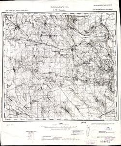
- Description:
- 1940
- Subject:
- Geographic Subject: Râmnicu Vâlcea, Topical Subject: Maps, and Topical Subject: Soviet Union
- Publisher:
- Генеральный штаб РККА
- Language:
- Russian
- Identifier:
- VAC9619-001677
- Genre:
- Topographic Maps and Military Maps
- Geographic Location:
- Coordinates: 45, 24, 45.3333, 24.5
- Related URL:
- Download GeoTIFF: https://drive.google.com/open?id=1C9ud1wkidRM66CKnYM_GNiv4tJQ74gYP and Catalog URL: https://iucat.iu.edu/catalog/5020129
- Abstract:
- Modern area represented: Râmnicu Vâlcea, Vâlcea county, Romania
- Call Number:
- G7000 s100 .S7 sheet L-35-97
- City:
- Рымнику Вылча (Râmnicu Vâlcea)
- Copyright Holder:
- No Copyright - United States
- Country:
- Румыния (Romania)
- Physical Description:
- Scale: 1:100,000
- Persistent URL:
- http://purl.dlib.indiana.edu/iudl/images/VAC9619/VAC9619-001677
- Provenance:
- DMA Topographic Center, Army Map Service Library, OMAHA, Atlasblatt, Library of Congress Geography & Map Division
-
- Description:
- 1877
- Subject:
- Topical Subject: Soviet Union, Topical Subject: Maps, and Geographic Subject: Strumok
- Publisher:
- Генеральный штаб РККА
- Language:
- Russian
- Date Created:
- 1916
- Identifier:
- VAC9619-001668
- Genre:
- Topographic Maps and Military Maps
- Geographic Location:
- Coordinates: 45.6667, 29, 46, 29.5
- Related URL:
- Download GeoTIFF: https://drive.google.com/open?id=1NH1x6hcaWJYBTNtwSqN67ONFP7RSfUJk and Catalog URL: https://iucat.iu.edu/catalog/5020129
- Abstract:
- Modern area represented: Strumok, Odessa oblast, Ukraine
- Call Number:
- G7000 s100 .S7 sheet L-35-83
- City:
- Чишмеле (Cişmele)
- Copyright Holder:
- No Copyright - United States
- State/Province:
- Бессарабия (Bessarabia)
- Physical Description:
- Scale: 1:100,000
- Persistent URL:
- http://purl.dlib.indiana.edu/iudl/images/VAC9619/VAC9619-001668
- Provenance:
- DMA Topographic Center, Army Map Service Library, OMAHA, Atlasblatt, Library of Congress Geography & Map Division
-
- Description:
- 1875
- Subject:
- Topical Subject: Maps, Topical Subject: Soviet Union, and Geographic Subject: Berezyne
- Publisher:
- Генеральный штаб РККА
- Language:
- Russian
- Date Created:
- 1916
- Identifier:
- VAC9619-001629
- Genre:
- Military Maps and Topographic Maps
- Geographic Location:
- Coordinates: 46, 29, 46.3333, 29.5
- Related URL:
- Catalog URL: https://iucat.iu.edu/catalog/5020129 and Download GeoTIFF: https://drive.google.com/open?id=1C3sEntFJccgyBICFoDtKC-3pwp46wFsk
- Abstract:
- Modern area represented: Berezyne, Odessa oblast, Ukraine.
- Call Number:
- G7000 s100 .S7 sheet L-35-71
- City:
- Березина (Berezyne)
- Copyright Holder:
- No Copyright - United States
- Country:
- СССР (USSR)
- State/Province:
- Бессарабия (Bessarabia)
- Physical Description:
- Scale: 1:100,000
- Persistent URL:
- http://purl.dlib.indiana.edu/iudl/images/VAC9619/VAC9619-001629
- Provenance:
- CIA Map Library
-
- Description:
- 1875
- Subject:
- Topical Subject: Maps, Geographic Subject: Berezyne, and Topical Subject: Soviet Union
- Publisher:
- Генеральный штаб РККА
- Language:
- Russian
- Date Created:
- 1916
- Identifier:
- VAC9619-001635
- Genre:
- Topographic Maps and Military Maps
- Geographic Location:
- Coordinates: 46, 29, 46.3333, 29.5
- Related URL:
- Catalog URL: https://iucat.iu.edu/catalog/5020129 and Download GeoTIFF: https://drive.google.com/file/d/1V5InYbVyYfed6G5yI-n23wDGBkHEh0Rn/view?usp=sharing
- Abstract:
- Modern area represented: Berezyne, Odessa oblast, Ukraine.
- Call Number:
- G7000 s100 .S7 sheet L-35-71
- City:
- Березина (Berezyne)
- Copyright Holder:
- No Copyright - United States
- Country:
- СССР (USSR)
- State/Province:
- Бессарабия (Bessarabia)
- Physical Description:
- Scale: 1:100,000
- Persistent URL:
- http://purl.dlib.indiana.edu/iudl/images/VAC9619/VAC9619-001635
- Provenance:
- CIA Map Library, Atlasblatt
-
- Description:
- 1872
- Subject:
- Topical Subject: Soviet Union, Geographic Subject: Ștefănești, and Topical Subject: Maps
- Publisher:
- Генеральный штаб РККА
- Language:
- Russian
- Date Created:
- 1894
- Identifier:
- VAC9619-001501
- Genre:
- Topographic Maps and Military Maps
- Geographic Location:
- Coordinates: 47.6667, 27, 48, 27.5
- Related URL:
- Catalog URL: https://iucat.iu.edu/catalog/5020129 and Download GeoTIFF: https://drive.google.com/file/d/1nXQvyN3376WtIPrwNB28E_5MwcpntFKz/view?usp=sharing
- Abstract:
- Modern area represented: Ștefănești, Rîşcani district, Moldova
- Call Number:
- G7000 s100 .S7 sheet L-35-7
- City:
- Стэфанештий (Ștefănești)
- Copyright Holder:
- No Copyright - United States
- Country:
- Румыния (Romania)
- State/Province:
- Бессарабия (Bessarabia)
- Physical Description:
- Scale: 1:100,000
- Persistent URL:
- http://purl.dlib.indiana.edu/iudl/images/VAC9619/VAC9619-001501
- Provenance:
- DMA Topographic Center, Army Map Service Library, OMAHA, Library of Congress Geography & Map Division, Atlasblatt
-
- Description:
- 1872
- Subject:
- Geographic Subject: Ștefănești, Topical Subject: Maps, and Topical Subject: Soviet Union
- Publisher:
- Генеральный штаб РККА
- Language:
- Russian
- Date Created:
- 1894
- Identifier:
- VAC9619-001500
- Genre:
- Military Maps and Topographic Maps
- Geographic Location:
- Coordinates: 47.6667, 27, 48, 27.5
- Related URL:
- Download GeoTIFF: https://drive.google.com/open?id=1Ls9NiFQljfKBN0cnQE-jwNyRfReCJGXH and Catalog URL: https://iucat.iu.edu/catalog/5020129
- Abstract:
- Modern area represented: Ștefănești, Rîşcani district, Moldova
- Call Number:
- G7000 s100 .S7 sheet L-35-7
- City:
- Стэфанештий (Ștefănești)
- Copyright Holder:
- No Copyright - United States
- Country:
- Румыния (Romania)
- State/Province:
- Бессарабия (Bessarabia)
- Physical Description:
- Scale: 1:100,000
- Persistent URL:
- http://purl.dlib.indiana.edu/iudl/images/VAC9619/VAC9619-001500
- Provenance:
- Library of Congress Geography & Map Division
-
- Description:
- 1882
- Subject:
- Geographic Subject: Fălciu, Topical Subject: Soviet Union, and Topical Subject: Maps
- Publisher:
- Генеральный штаб РККА
- Language:
- Russian
- Date Created:
- 1895
- Identifier:
- VAC9619-001624
- Genre:
- Military Maps and Topographic Maps
- Geographic Location:
- Coordinates: 46, 28, 46.3333, 28.5
- Related URL:
- Download GeoTIFF: https://drive.google.com/open?id=1R8nvsfdEa2fLUDB7owObtCnBbU6flTtX and Catalog URL: https://iucat.iu.edu/catalog/5020129
- Abstract:
- Modern area represented: Fălciu, Vaslui county, Romania
- Call Number:
- G7000 s100 .S7 sheet L-35-69
- City:
- Фельчиул (Fălciu)
- Copyright Holder:
- No Copyright - United States
- Country:
- Румыния (Romania)
- State/Province:
- Бессарабия (Bessarabia)
- Physical Description:
- Scale: 1:100,000
- Persistent URL:
- http://purl.dlib.indiana.edu/iudl/images/VAC9619/VAC9619-001624
- Provenance:
- CIA Map Library, Atlasblatt
-
- Description:
- 1893
- Subject:
- Topical Subject: Soviet Union, Topical Subject: Maps, and Geographic Subject: Adjud
- Publisher:
- Генеральный штаб РККА
- Language:
- Russian
- Date Created:
- 1896
- Identifier:
- VAC9619-001602
- Genre:
- Topographic Maps and Military Maps
- Geographic Location:
- Coordinates: 46, 27, 46.3333, 27.5
- Related URL:
- Catalog URL: https://iucat.iu.edu/catalog/5020129 and Download GeoTIFF: https://drive.google.com/open?id=1D56jymB_bCQoeecca7VpmVUwX0ZswpuS
- Abstract:
- Modern area represented: Adjud, Vrancea county, Romania
- Call Number:
- G7000 s100 .S7 sheet L-35-67
- City:
- Аджуд Ноуа (Adjudu Nou)
- Copyright Holder:
- No Copyright - United States
- Country:
- Румыния (Romania)
- Physical Description:
- Scale: 1:100,000
- Persistent URL:
- http://purl.dlib.indiana.edu/iudl/images/VAC9619/VAC9619-001602
- Provenance:
- DMA Topographic Center, Army Map Service Library, OMAHA, Library of Congress Geography & Map Division
-
- Description:
- 1893
- Subject:
- Topical Subject: Maps, Topical Subject: Soviet Union, and Geographic Subject: Adjud
- Publisher:
- Генеральный штаб РККА
- Language:
- Russian
- Date Created:
- 1896
- Identifier:
- VAC9619-001612
- Genre:
- Topographic Maps and Military Maps
- Geographic Location:
- Coordinates: 46, 27, 46.3333, 27.5
- Related URL:
- Catalog URL: https://iucat.iu.edu/catalog/5020129 and Download GeoTIFF: https://drive.google.com/file/d/1-KZEpM-IuVFk53H5qXK4isCnJ-3W7KMJ/view?usp=sharing
- Abstract:
- Modern area represented: Adjud, Vrancea county, Romania
- Call Number:
- G7000 s100 .S7 sheet L-35-67
- City:
- Аджуд Ноуа (Adjudu Nou)
- Copyright Holder:
- No Copyright - United States
- Country:
- Румыния (Romania)
- Physical Description:
- Scale: 1:100,000
- Persistent URL:
- http://purl.dlib.indiana.edu/iudl/images/VAC9619/VAC9619-001612
- Provenance:
- CIA Map Library
-
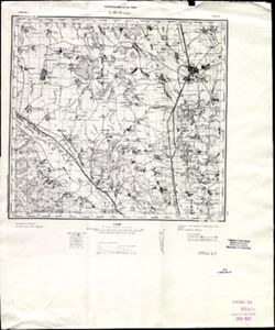
- Description:
- 1883
- Subject:
- Geographic Subject: Târgu Ocna, Topical Subject: Soviet Union, and Topical Subject: Maps
- Publisher:
- Генеральный штаб РККА
- Language:
- Russian
- Date Created:
- 1901
- Identifier:
- VAC9619-001591
- Genre:
- Topographic Maps and Military Maps
- Geographic Location:
- Coordinates: 46, 26.5, 46.3333, 27
- Related URL:
- Catalog URL: https://iucat.iu.edu/catalog/5020129 and Download GeoTIFF: https://drive.google.com/open?id=10x2oiAscdChrKJVEN93a3hEPHjpl_70K
- Abstract:
- Modern area represented: Târgu Ocna, Bacău county, Romania
- Call Number:
- G7000 s100 .S7 sheet L-35-66
- City:
- Тыргул Окна (Târgu Ocna)
- Copyright Holder:
- No Copyright - United States
- Country:
- Румыния (Romania)
- Physical Description:
- Scale: 1:100,000
- Persistent URL:
- http://purl.dlib.indiana.edu/iudl/images/VAC9619/VAC9619-001591
- Provenance:
- CIA Map Library, Atlasblatt
-

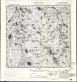
- Description:
- 1889
- Subject:
- Geographic Subject: Sighișoara, Topical Subject: Soviet Union, and Topical Subject: Maps
- Publisher:
- Генеральный штаб РККА
- Language:
- Russian
- Date Created:
- 1940
- Identifier:
- VAC9619-001572
- Genre:
- Topographic Maps and Military Maps
- Geographic Location:
- Coordinates: 46, 24.5, 46.3333, 25
- Related URL:
- Catalog URL: https://iucat.iu.edu/catalog/5020129 and Download GeoTIFF: https://drive.google.com/open?id=1pMjt1y7xJ_zezttERad19SLcAJyJ7ok-
- Abstract:
- Modern area represented: Sighișoara, Mureş county, Romania
- Call Number:
- G7000 s100 .S7 sheet L-35-62
- City:
- Сигишоара (Sighișoara)
- Copyright Holder:
- No Copyright - United States
- Country:
- Венгрия (Hungary) and Румыния (Romania)
- Physical Description:
- Scale: 1:100,000
- Persistent URL:
- http://purl.dlib.indiana.edu/iudl/images/VAC9619/VAC9619-001572
- Provenance:
- Library of Congress Geography & Map Division, Atlasblatt, DMA Topographic Center, Army Map Service Library, OMAHA
-
- Description:
- 1875
- Subject:
- Geographic Subject: Volintiri, Topical Subject: Soviet Union, and Topical Subject: Maps
- Publisher:
- Генеральный штаб РККА
- Language:
- Russian
- Date Created:
- 1940
- Identifier:
- VAC9619-001581
- Genre:
- Topographic Maps and Military Maps
- Geographic Location:
- Coordinates: 46.3333, 29.5, 46.6667, 30
- Related URL:
- Download GeoTIFF: https://drive.google.com/open?id=1yjBpyWEhLGUL0b_IOaIHHjcBR0P7r7Hi and Catalog URL: https://iucat.iu.edu/catalog/5020129
- Abstract:
- Modern area represented: Volintiri, Ștefan Vodă district, Moldova
- Call Number:
- G7000 s100 .S7 sheet L-35-60
- Caption:
- Не подлежит оглашению
- City:
- Волинтирь (Volintiri)
- Copyright Holder:
- No Copyright - United States
- Country:
- СССР (USSR)
- State/Province:
- Украинская ССР (Ukrainian Soviet Socialist Republic), Одесская область (Odessa oblast), Молдавская АССР (Moldavian Autonomous Soviet Socialist Republic), and...
- Physical Description:
- Scale: 1:100,000
- Persistent URL:
- http://purl.dlib.indiana.edu/iudl/images/VAC9619/VAC9619-001581
- Provenance:
- Library of Congress Geography & Map Division, Atlasblatt, DMA Topographic Center, Army Map Service Library, OMAHA
-
- Description:
- 1875
- Subject:
- Topical Subject: Soviet Union, Geographic Subject: Leova, and Topical Subject: Maps
- Publisher:
- Генеральный штаб РККА
- Language:
- Russian
- Date Created:
- 1940
- Identifier:
- VAC9619-001576
- Genre:
- Military Maps and Topographic Maps
- Geographic Location:
- Coordinates: 46.3333, 28, 46.6667, 28.5
- Related URL:
- Catalog URL: https://iucat.iu.edu/catalog/5020129 and Download GeoTIFF: https://drive.google.com/open?id=1W71to7iMT8UwC4o77msQuVXKGW3_2Y6g
- Abstract:
- Modern area represented: Leova, Leova district, Moldova
- Call Number:
- G7000 s100 .S7 sheet L-35-57
- City:
- Леово (Leovo)
- Copyright Holder:
- No Copyright - United States
- Country:
- Румыния (Romania)
- State/Province:
- Бессарабия (Bessarabia)
- Physical Description:
- Scale: 1:100,000
- Persistent URL:
- http://purl.dlib.indiana.edu/iudl/images/VAC9619/VAC9619-001576
- Provenance:
- CIA Map Library, Atlasblatt
-
- Description:
- 1891
- Subject:
- Topical Subject: Maps, Geographic Subject: Dragomireşti, and Topical Subject: Soviet Union
- Publisher:
- Генеральный штаб РККА
- Language:
- Russian
- Date Created:
- 1894
- Identifier:
- VAC9619-001748
- Genre:
- Military Maps and Topographic Maps
- Geographic Location:
- Coordinates: 46.3333, 27, 46.6667, 27.5
- Related URL:
- Catalog URL: https://iucat.iu.edu/catalog/5020129 and Download GeoTIFF: https://drive.google.com/open?id=1wFqpotQXaQkK_nr3OeMvAnjOZariL8r4
- Abstract:
- Modern area represented: Dragomireşti, Vaslui county, Romania
- Call Number:
- G7000 s100 .S7 sheet L-35-55
- City:
- Драгомирешти (Dragomireşti)
- Copyright Holder:
- No Copyright - United States
- Country:
- Румыния (Romania)
- Physical Description:
- Scale: 1:100,000
- Persistent URL:
- http://purl.dlib.indiana.edu/iudl/images/VAC9619/VAC9619-001748
- Provenance:
- DMA Topographic Center, Army Map Service Library, OMAHA, Library of Congress Geography & Map Division
-
- Description:
- 1889
- Subject:
- Geographic Subject: Moineşti, Topical Subject: Soviet Union, and Topical Subject: Maps
- Publisher:
- Генеральный штаб РККА
- Language:
- Russian
- Date Created:
- 1896
- Identifier:
- VAC9619-001738
- Genre:
- Topographic Maps and Military Maps
- Geographic Location:
- Coordinates: 46.3333, 26, 46.6667, 26.5
- Related URL:
- Catalog URL: https://iucat.iu.edu/catalog/5020129 and Download GeoTIFF: https://drive.google.com/file/d/1IXAviaTHJut1rVEAfX8jHRexV4fPJDuT/view?usp=sharing
- Abstract:
- Modern area represented: Moineşti, Bacău county, Romania
- Call Number:
- G7000 s100 .S7 sheet L-35-53
- City:
- Мойнешти (Moineşti)
- Copyright Holder:
- No Copyright - United States
- Country:
- Румыния (Romania)
- Physical Description:
- Scale: 1:100,000
- Persistent URL:
- http://purl.dlib.indiana.edu/iudl/images/VAC9619/VAC9619-001738
- Provenance:
- DMA Topographic Center, Army Map Service Library, OMAHA, Atlasblatt, Library of Congress Geography & Map Division
-
- Description:
- 1889
- Subject:
- Geographic Subject: Moineşti, Topical Subject: Maps, and Topical Subject: Soviet Union
- Publisher:
- Генеральный штаб РККА
- Language:
- Russian
- Date Created:
- 1896
- Identifier:
- VAC9619-001730
- Genre:
- Military Maps and Topographic Maps
- Geographic Location:
- Coordinates: 46.3333, 26, 46.6667, 26.5
- Related URL:
- Catalog URL: https://iucat.iu.edu/catalog/5020129 and Download GeoTIFF: https://drive.google.com/open?id=1VlE66H8MtUlVaLWqYwvb7RW6QeC07_W5
- Abstract:
- Modern area represented: Moineşti, Bacău county, Romania
- Call Number:
- G7000 s100 .S7 sheet L-35-53
- City:
- Мойнешти (Moineşti)
- Copyright Holder:
- No Copyright - United States
- Country:
- Румыния (Romania)
- Physical Description:
- Scale: 1:100,000
- Persistent URL:
- http://purl.dlib.indiana.edu/iudl/images/VAC9619/VAC9619-001730
- Provenance:
- Library of Congress G & M Division, Army Map Service Library
-
- Description:
- 1875
- Subject:
- Topical Subject: Soviet Union, Geographic Subject: Tiraspol, and Topical Subject: Maps
- Publisher:
- Генеральный штаб РККА
- Language:
- Russian
- Date Created:
- 1929
- Identifier:
- VAC9619-001718
- Genre:
- Military Maps and Topographic Maps
- Geographic Location:
- Coordinates: 46.6667, 29.5, 47, 30
- Related URL:
- Catalog URL: https://iucat.iu.edu/catalog/5020129 and Download GeoTIFF: https://drive.google.com/open?id=1-hf6LeF3eCsdwqOwg-k3BLxRce9hfH9t
- Abstract:
- Modern area represented: Tiraspol, Stînga Nistrului, Moldova
- Call Number:
- G7000 s100 .S7 sheet L-35-48
- Caption:
- Не подлежит оглашению
- City:
- Тирасполь (Tiraspol)
- Copyright Holder:
- No Copyright - United States
- State/Province:
- Украинская ССР (Ukrainian Soviet Socialist Republic), Молдавская АССР (Moldavian Autonomous Soviet Socialist Republic), Бессарабия (Bessarabia), and Одесская...
- Physical Description:
- Scale: 1:100,000
- Persistent URL:
- http://purl.dlib.indiana.edu/iudl/images/VAC9619/VAC9619-001718
- Provenance:
- CIA Map Library
-
- Description:
- 1875
- Subject:
- Topical Subject: Maps, Topical Subject: Soviet Union, and Geographic Subject: Tighina
- Publisher:
- Генеральный штаб РККА
- Language:
- Russian
- Date Created:
- 1940
- Identifier:
- VAC9619-001549
- Genre:
- Military Maps and Topographic Maps
- Geographic Location:
- Coordinates: 46.6667, 29, 47, 29.5
- Related URL:
- Catalog URL: https://iucat.iu.edu/catalog/5020129 and Download GeoTIFF: https://drive.google.com/open?id=1MZ4PrCBw5im-5F634wMbg7bDcKcTTsDN
- Abstract:
- Modern area represented: Tighina, Bender municipality, Moldova
- Call Number:
- G7000 s100 .S7 sheet L-35-47
- Caption:
- Не подлежит оглашению
- City:
- Бендеры (Bendery)
- Copyright Holder:
- No Copyright - United States
- State/Province:
- Бессарабия (Bessarabia), Украинская ССР (Ukrainian Soviet Socialist Republic), and Молдавская АССР (Moldavian Autonomous Soviet Socialist Republic)
- Physical Description:
- Scale: 1:100,000
- Persistent URL:
- http://purl.dlib.indiana.edu/iudl/images/VAC9619/VAC9619-001549
- Provenance:
- CIA Map Library, Geographisches Institut der Universität Berlin
-
- Description:
- 1894
- Subject:
- Topical Subject: Soviet Union, Topical Subject: Maps, and Geographic Subject: Negreşti
- Publisher:
- Генеральный штаб РККА
- Language:
- Russian
- Date Created:
- 1895
- Identifier:
- VAC9619-001541
- Genre:
- Military Maps and Topographic Maps
- Geographic Location:
- Coordinates: 46.6667, 27, 47, 27.5
- Related URL:
- Download GeoTIFF: https://drive.google.com/open?id=1KiVcQS9h2V8YjS-0jjEWuBTmMX1dih2O and Catalog URL: https://iucat.iu.edu/catalog/5020129
- Abstract:
- Modern area represented: Negreşti, Strășeni district, Moldova
- Call Number:
- G7000 s100 .S7 sheet L-35-43
- City:
- Негрешть (Negreşti)
- Copyright Holder:
- No Copyright - United States
- Country:
- Румыния (Romania)
- Physical Description:
- Scale: 1:100,000
- Persistent URL:
- http://purl.dlib.indiana.edu/iudl/images/VAC9619/VAC9619-001541
- Provenance:
- DMA Topographic Center, Army Map Service Library, Library of Congress Geography & Map Division
-
- Description:
- 1888
- Subject:
- Topical Subject: Maps, Geographic Subject: Roman, and Topical Subject: Soviet Union
- Publisher:
- Генеральный штаб РККА
- Language:
- Russian
- Date Created:
- 1940
- Identifier:
- VAC9619-001540
- Genre:
- Military Maps and Topographic Maps
- Geographic Location:
- Coordinates: 46.6667, 26.5, 47, 27
- Related URL:
- Download GeoTIFF: https://drive.google.com/open?id=1i2pvbe1wRYaxyTOVF2cgHePtUEz_ZnoF and Catalog URL: https://iucat.iu.edu/catalog/5020129
- Abstract:
- Modern area represented: Roman, Neamţ county, Romania
- Call Number:
- G7000 s100 .S7 sheet L-35-42
- City:
- Роман (Roman)
- Copyright Holder:
- No Copyright - United States
- Country:
- Румыния (Romania)
- Physical Description:
- Scale: 1:100,000
- Persistent URL:
- http://purl.dlib.indiana.edu/iudl/images/VAC9619/VAC9619-001540
- Provenance:
- CIA Map Library
-
- Description:
- 1914
- Subject:
- Topical Subject: Maps, Topical Subject: Soviet Union, and Geographic Subject: Grosulovo
- Publisher:
- Генеральный штаб РККА
- Language:
- Russian
- Date Created:
- 1933
- Identifier:
- VAC9619-001532
- Genre:
- Military Maps and Topographic Maps
- Geographic Location:
- Coordinates: 47, 29.5, 47.3333, 30
- Related URL:
- Download GeoTIFF: https://drive.google.com/open?id=1kyU5R5m-tJespCHRUtLSwhXDplcG5011 and Catalog URL: https://iucat.iu.edu/catalog/5020129
- Abstract:
- Modern area represented: Grosulovo, Odessa oblast, Ukraine
- Call Number:
- G7000 s100 .S7 sheet L-35-36
- Caption:
- Не подлежит оглашению
- City:
- Гросулово (Grosulovo)
- Copyright Holder:
- No Copyright - United States
- State/Province:
- Молдавская АССР (Moldavian Autonomous Soviet Socialist Republic), Украинская ССР (Ukrainian Soviet Socialist Republic), and Одесская область (Odessa oblast)
- Physical Description:
- Scale: 1:100,000
- Persistent URL:
- http://purl.dlib.indiana.edu/iudl/images/VAC9619/VAC9619-001532
- Provenance:
- CIA Map Library, Atlasblatt
-
- Description:
- 1874
- Subject:
- Topical Subject: Soviet Union, Geographic Subject: Hryhoriopol, and Topical Subject: Maps
- Publisher:
- Генеральный штаб РККА
- Language:
- Russian
- Date Created:
- 1916
- Identifier:
- VAC9619-001531
- Genre:
- Military Maps and Topographic Maps
- Geographic Location:
- Coordinates: 47, 29, 47.3333, 29.5
- Related URL:
- Download GeoTIFF: https://drive.google.com/open?id=19E1iGxfkWQpzLaVEysUOs-ieDNfm5LYO and Catalog URL: https://iucat.iu.edu/catalog/5020129
- Abstract:
- Modern area represented: Hryhoriopol, Stînga Nistrului, Moldova
- Call Number:
- G7000 s100 .S7 sheet L-35-35
- Caption:
- Не подлежит оглашению
- City:
- Григориополь (Hryhoriopol)
- Copyright Holder:
- No Copyright - United States
- State/Province:
- Бессарабия (Bessarabia), Молдавская АССР (Moldavian Autonomous Soviet Socialist Republic), and Украинская ССР (Ukrainian Soviet Socialist Republic)
- Physical Description:
- Scale: 1:100,000
- Persistent URL:
- http://purl.dlib.indiana.edu/iudl/images/VAC9619/VAC9619-001531
- Provenance:
- DMA Topographic Center, Army Map Service Library, Library of Congress Geography & Map Division
-
- Description:
- 1874
- Subject:
- Geographic Subject: Chisinau, Topical Subject: Maps, and Topical Subject: Soviet Union
- Publisher:
- Генеральный штаб РККА
- Language:
- Russian
- Date Created:
- 1916
- Identifier:
- VAC9619-001530
- Genre:
- Military Maps and Topographic Maps
- Geographic Location:
- Coordinates: 47, 28.5, 47.3333, 29
- Related URL:
- Download GeoTIFF: https://drive.google.com/open?id=1xHhtT8h9OlNdn0pYOldU3_y0HXwzxGxP and Catalog URL: https://iucat.iu.edu/catalog/5020129
- Abstract:
- Modern area represented: Chisinau, Chișinău municipality, Moldova
- Call Number:
- G7000 s100 .S7 sheet L-35-34
- City:
- Кишинев (Kischinew)
- Copyright Holder:
- No Copyright - United States
- State/Province:
- Бессарабия (Bessarabia)
- Physical Description:
- Scale: 1:100,000
- Persistent URL:
- http://purl.dlib.indiana.edu/iudl/images/VAC9619/VAC9619-001530
- Provenance:
- DMA Topographic Center, Army Map Service Library, OMAHA, Library of Congress Geography & Map Division, Reichsamt für Landesaufnahme, Kartensammlung
-
- Description:
- 1873
- Subject:
- Topical Subject: Soviet Union, Topical Subject: Maps, and Geographic Subject: Călărasi-Targ
- Publisher:
- Генеральный штаб РККА
- Language:
- Russian
- Date Created:
- 1940
- Identifier:
- VAC9619-001529
- Genre:
- Topographic Maps and Military Maps
- Geographic Location:
- Coordinates: 47, 28, 47.3333, 28.5
- Related URL:
- Download GeoTIFF: https://drive.google.com/open?id=1tChuAu9yqWs5ys8Z7tNhOEmgq69Apb3I and Catalog URL: https://iucat.iu.edu/catalog/5020129
- Abstract:
- Modern area represented: Călărasi-Targ, Călăraşi county, Moldova
- Call Number:
- G7000 s100 .S7 sheet L-35-33
- City:
- Калараш-Тырг (Călărasi-Targ)
- Copyright Holder:
- No Copyright - United States
- Country:
- Румыния (Romania)
- State/Province:
- Бессарабия (Bessarabia)
- Physical Description:
- Scale: 1:100,000
- Persistent URL:
- http://purl.dlib.indiana.edu/iudl/images/VAC9619/VAC9619-001529
- Provenance:
- CIA Map Library
-

- Description:
- 1913
- Subject:
- Topical Subject: Maps, Topical Subject: Soviet Union, and Geographic Subject: Olteniţa
- Publisher:
- Генеральный штаб РККА
- Language:
- Russian
- Identifier:
- VAC9619-001810
- Genre:
- Topographic Maps and Military Maps
- Geographic Location:
- Coordinates: 44, 26.5, 44.3333, 27
- Related URL:
- Download GeoTIFF: https://drive.google.com/open?id=1K5wkGkvRkUeJl-5zDMfxLkj3JNBf0BuA and Catalog URL: https://iucat.iu.edu/catalog/5020129
- Abstract:
- Modern area represented: Olteniţa, Călăraşi county, Romania
- Call Number:
- G7000 s100 .S7 sheet L-35-138
- City:
- Олтеница (Olteniţa)
- Copyright Holder:
- No Copyright - United States
- Country:
- Румыния (Romania)
- Physical Description:
- Scale: 1:100,000
- Persistent URL:
- http://purl.dlib.indiana.edu/iudl/images/VAC9619/VAC9619-001810
- Provenance:
- DMA Topographic Center, Army Map Service Library, OMAHA, Atlasblatt, Library of Congress Geography & Map Division
-
- Description:
- 1905
- Subject:
- Topical Subject: Soviet Union, Topical Subject: Maps, and Geographic Subject: Roșiorii de Vede
- Publisher:
- Генеральный штаб РККА
- Language:
- Russian
- Date Created:
- 1940
- Identifier:
- VAC9619-001805
- Genre:
- Topographic Maps and Military Maps
- Geographic Location:
- Coordinates: 44, 24.5, 44.3333, 25
- Related URL:
- Catalog URL: https://iucat.iu.edu/catalog/5020129 and Download GeoTIFF: https://drive.google.com/open?id=1FL58q-DJnIMTpAZZgJSsyZUt5SSzmh7X
- Abstract:
- Modern area represented: Roșiorii de Vede, Teleorman county, Romania
- Call Number:
- G7000 s100 .S7 sheet L-35-134
- City:
- Рошиори - Де Веде (Roșiorii de Vede)
- Copyright Holder:
- No Copyright - United States
- Country:
- Румыния (Romania)
- Physical Description:
- Scale: 1:100,000
- Persistent URL:
- http://purl.dlib.indiana.edu/iudl/images/VAC9619/VAC9619-001805
- Provenance:
- DMA Topographic Center, Army Map Service Library, Library of Congress Geography & Map Division
-
- Description:
- 1897
- Subject:
- Topical Subject: Maps, Topical Subject: Soviet Union, and Geographic Subject: Slobozia
- Publisher:
- Генеральный штаб РККА
- Language:
- Russian
- Date Created:
- 1900
- Identifier:
- VAC9619-001799
- Genre:
- Military Maps and Topographic Maps
- Geographic Location:
- Coordinates: 44.3333, 27, 44.6667, 27.5
- Related URL:
- Catalog URL: https://iucat.iu.edu/catalog/5020129 and Download GeoTIFF: https://drive.google.com/open?id=19PD0saZGwZmsVe87Ez_L0r_wN1P2Df2Z
- Abstract:
- Modern area represented: Slobozia, Ialomiţa county, Romania
- Call Number:
- G7000 s100 .S7 sheet L-35-127
- City:
- Слобозия (Slobozia)
- Copyright Holder:
- No Copyright - United States
- Country:
- Румыния (Romania)
- Physical Description:
- Scale: 1:100,000
- Persistent URL:
- http://purl.dlib.indiana.edu/iudl/images/VAC9619/VAC9619-001799
- Provenance:
- DMA Topographic Center, Army Map Service Library, OMAHA, Atlasblatt, Library of Congress Geography & Map Division
-
- Description:
- 1883
- Subject:
- Geographic Subject: Săruleştii Noi, Topical Subject: Maps, and Topical Subject: Soviet Union
- Publisher:
- Генеральный штаб РККА
- Language:
- Russian
- Date Created:
- 1900
- Identifier:
- VAC9619-001797
- Genre:
- Topographic Maps and Military Maps
- Geographic Location:
- Coordinates: 44.3333, 26.5, 44.6667, 27
- Related URL:
- Download GeoTIFF: https://drive.google.com/open?id=1EesHE3L4H_0ViZpG8C0yFlmV2wsNjrkU and Catalog URL: https://iucat.iu.edu/catalog/5020129
- Abstract:
- Modern area represented: Săruleştii Noi, Călăraşi county, Romania
- Call Number:
- G7000 s100 .S7 sheet L-35-126
- City:
- Сэрулешти (Săruleştii)
- Copyright Holder:
- No Copyright - United States
- Country:
- Румыния (Romania)
- Physical Description:
- Scale: 1:100,000
- Persistent URL:
- http://purl.dlib.indiana.edu/iudl/images/VAC9619/VAC9619-001797
- Provenance:
- DMA Topographic Center, Army Map Service Library, OMAHA, Atlasblatt, Library of Congress Geography & Map Division
-
- Description:
- 1883
- Subject:
- Topical Subject: Soviet Union, Geographic Subject: Buftea, and Topical Subject: Maps
- Publisher:
- Генеральный штаб РККА
- Language:
- Russian
- Date Created:
- 1896
- Identifier:
- VAC9619-001789
- Genre:
- Military Maps and Topographic Maps
- Geographic Location:
- Coordinates: 44.3333, 25.5, 44.6667, 26
- Related URL:
- Catalog URL: https://iucat.iu.edu/catalog/5020129 and Download GeoTIFF: https://drive.google.com/open?id=16BeHRQn4JHBkNM5TA9YEoKqFO9HFEEMk
- Abstract:
- Modern area represented: Buftea, Ilfov county, Romania
- Call Number:
- G7000 s100 .S7 sheet L-35-124
- City:
- Буфтя (Buftea)
- Copyright Holder:
- No Copyright - United States
- Country:
- Румыния (Romania)
- Physical Description:
- Scale: 1:100,000
- Persistent URL:
- http://purl.dlib.indiana.edu/iudl/images/VAC9619/VAC9619-001789
- Provenance:
- DMA Topographic Center, Army Map Service Library, OMAHA, Atlasblatt, Library of Congress Geography & Map Division
