
Search Constraints
You searched for:
Campus
IUB
Remove constraint Campus: IUB
Pages
0-99 pages
Remove constraint Pages: 0-99 pages
Subject
Mountains
Remove constraint Subject: Mountains
State/Province
California
Remove constraint State/Province: California
« Previous |
1 - 20 of 1,519
|
Next »
Search Results
-
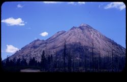
- Description:
- 100 f 8 tl
- Subject:
- Hills, Funeral Mountains (Calif.), Funeral Mountains Wilderness (Calif.), Mountains, Shrubs, Furnace Creek (Calif.), Rocks, and Clouds
- Series:
- 2-55
- Creator:
- Cushman, Charles W., 1896-1972
- Date Created:
- 1955-02-27
- Genre:
- Landscape photographs
- Frame Number:
- 29
- Street Address:
- Furance Creek-Death Valley Junction Road
- County:
- Mono and Inyo
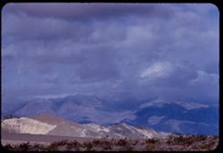
- Abstract:
- North toward Funeral Mtns
- Call Number:
- P07586
- City:
- Death Valley Junction
- Country:
- United States
- State/Province:
- California
- Alternate Identifier:
- 255.29
- Persistent URL:
- http://purl.dlib.indiana.edu/iudl/archives/cushman/P07586
- Holding Location:
- Bloomington - University Archives
Wells Library E460
1320 E 10th St.
Bloomington, IN 47405
Contact at archives@indiana.edu, 812-855-1127
-
- Description:
- 100 f 8 tl
- Subject:
- Hills, Tom's Place, Mountains, Utility poles, Sierra Nevada (Calif. and Nev.), and Plants
- Series:
- 26-55
- Creator:
- Cushman, Charles W., 1896-1972
- Date Created:
- 1955-09-26
- Genre:
- Landscape photographs
- Frame Number:
- 35
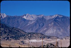
- Street Address:
- United States Highway 395
- Abstract:
- Dark-colored mtns west from Tom's Place
- Call Number:
- P08417
- Country:
- United States
- State/Province:
- California
- Alternate Identifier:
- 2655.35
- Persistent URL:
- http://purl.dlib.indiana.edu/iudl/archives/cushman/P08417
- Holding Location:
- Bloomington - University Archives
Wells Library E460
1320 E 10th St.
Bloomington, IN 47405
Contact at archives@indiana.edu, 812-855-1127
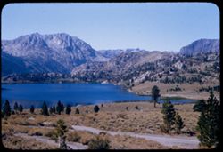
-
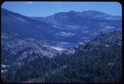
- Description:
- 100 f 8 tl
- Subject:
- Lakes & ponds, Mountains, Waterfronts, and Lake Crowley (Calif.)
- Series:
- 27-55
- Creator:
- Cushman, Charles W., 1896-1972
- Date Created:
- 1955-09-26
- Genre:
- Landscape photographs
- Frame Number:
- 1
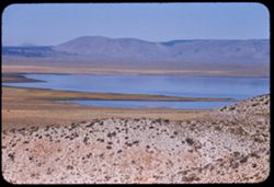
- Street Address:
- United States Highway 395
- County:
- Mono
- Abstract:
- Crowley Lake from US 395 above
- Call Number:
- P08421
- Country:
- United States
- State/Province:
- California
- Alternate Identifier:
- 2755.1
- Persistent URL:
- http://purl.dlib.indiana.edu/iudl/archives/cushman/P08421
- Holding Location:
- Bloomington - University Archives
Wells Library E460
1320 E 10th St.
Bloomington, IN 47405
Contact at archives@indiana.edu, 812-855-1127
-
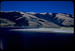
- Description:
- 100 f 7 tl
- Subject:
- Valleys, Death Valley (Calif. and Nev.), Mountains, Shrubs, and Dunes
- Series:
- 3-55
- Creator:
- Cushman, Charles W., 1896-1972
- Date Created:
- 1955-02-27
- Genre:
- Landscape photographs
- Frame Number:
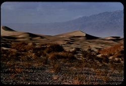
- 25
- County:
- Inyo
- Abstract:
- Sand Dunes near Stove Pipe Wells
- Call Number:
- P07616
- City:
- Stovepipe Wells
- Country:
- United States
- State/Province:
- California
- Alternate Identifier:
- 355.25
- Persistent URL:
- http://purl.dlib.indiana.edu/iudl/archives/cushman/P07616
- Holding Location:
- Bloomington - University Archives
Wells Library E460
1320 E 10th St.
Bloomington, IN 47405
Contact at archives@indiana.edu, 812-855-1127
-
- Description:
- 50 f 8
- Subject:
- Black Butte (Siskiyou County, Calif.), Lava domes, Lassen Volcanic National Park (Calif.), Volcanic domes, Mountains, Shrubs, Trees, Cascade Range, Buttes, C...
- Series:
- 6-54
- Creator:
- Cushman, Charles W., 1896-1972
- Date Created:
- 1954-08-20
- Genre:
- Landscape photographs
- Frame Number:
- 26
- County:
- Siskiyou
- Abstract:
- That same triple cone (Black Butte) west of Mt Shasta.
- Call Number:
- P07243
- Country:
- United States
- State/Province:
- California
- Physical Description:
- masked.
- Alternate Identifier:
- 654.26
- Persistent URL:
- http://purl.dlib.indiana.edu/iudl/archives/cushman/P07243
- Holding Location:
- Bloomington - University Archives
Wells Library E460
1320 E 10th St.
Bloomington, IN 47405
Contact at archives@indiana.edu, 812-855-1127
-
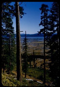
- Description:
- 100 f 5.6 tl
- Subject:
- Lakes & ponds, Mountains, Sierra Nevada (Calif. and Nev.), Trees, Emigrant Gap (Calif. : Gap), and Reservoirs
- Series:
- 15-58
- Creator:
- Cushman, Charles W., 1896-1972
- Date Created:
- 1958-08-22
- Genre:
- Landscape photographs
- Frame Number:
- 4
- Abstract:
- Lake
- Call Number:
- P10110
- Country:
- United States
- State/Province:
- Nevada and California
- Alternate Identifier:
- 1558.4
- Persistent URL:
- http://purl.dlib.indiana.edu/iudl/archives/cushman/P10110
- Holding Location:
- Bloomington - University Archives
Wells Library E460
1320 E 10th St.
Bloomington, IN 47405
Contact at archives@indiana.edu, 812-855-1127
-
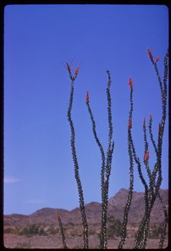
- Description:
- 100 f 8 tl
- Subject:
- Deserts, Flowers, Ocotillo, Mountains, Shrubs, and Clouds
- Series:
- 11-59
- Creator:
- Cushman, Charles W., 1896-1972
- Date Created:
- 1959-03-24
- Genre:
- Identification photographs
- Frame Number:
- 11
- County:
- Yuma and Riverside
- Abstract:
- Our finest ocotillo - 15-20 mi east of Blythe
- Call Number:
- P10736
- City:
- Blythe and Quartzsite
- Country:
- United States
- State/Province:
- Arizona and California
- Alternate Identifier:
- 1159.11
- Persistent URL:
- http://purl.dlib.indiana.edu/iudl/archives/cushman/P10736
- Holding Location:
- Bloomington - University Archives
Wells Library E460
1320 E 10th St.
Bloomington, IN 47405
Contact at archives@indiana.edu, 812-855-1127
-
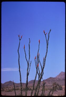
- Description:
- 250 f 5.6
- Subject:
- Deserts, Flowers, Ocotillo, Mountains, Shrubs, and Clouds
- Series:
- 11-59
- Creator:
- Cushman, Charles W., 1896-1972
- Date Created:
- 1959-03-24
- Genre:
- Identification photographs
- Frame Number:
- 12
- County:
- Yuma and Riverside
- Abstract:
- Our finest ocotillo - 15-20 mi east of Blythe
- Call Number:
- P10737
- City:
- Blythe and Quartzsite
- Country:
- United States
- State/Province:
- Arizona and California
- Alternate Identifier:
- 1159.12
- Persistent URL:
- http://purl.dlib.indiana.edu/iudl/archives/cushman/P10737
- Holding Location:
- Bloomington - University Archives
Wells Library E460
1320 E 10th St.
Bloomington, IN 47405
Contact at archives@indiana.edu, 812-855-1127
-
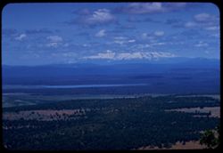
- Description:
- 100 f 8 TL
- Subject:
- Lakes & ponds, Shasta, Mount (Calif. : Mountain), Mountains, Trees, and Clouds
- Series:
- 10-58
- Creator:
- Cushman, Charles W., 1896-1972
- Date Created:
- 1958-06-13
- Genre:
- Landscape photographs
- Frame Number:
- 25
- County:
- Shasta
- Abstract:
- Mt Shasta from SE
- Call Number:
- P09964
- Country:
- United States
- State/Province:
- California
- Alternate Identifier:
- 1058.25
- Persistent URL:
- http://purl.dlib.indiana.edu/iudl/archives/cushman/P09964
- Holding Location:
- Bloomington - University Archives
Wells Library E460
1320 E 10th St.
Bloomington, IN 47405
Contact at archives@indiana.edu, 812-855-1127
-
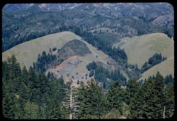
- Description:
- 100 f 6.3 tl
- Subject:
- Hills, Mountains, Tamalpais, Mount (Calif.), and Trees
- Series:
- 2-56
- Creator:
- Cushman, Charles W., 1896-1972
- Date Created:
- 1956-03-14
- Genre:
- Landscape photographs
- Frame Number:
- 2
- County:
- Marin
- Abstract:
- From road on West shoulder of Mt. Tamalpais: Folded hills to north
- Call Number:
- P08568
- Country:
- United States
- State/Province:
- California
- Alternate Identifier:
- 256.2
- Persistent URL:
- http://purl.dlib.indiana.edu/iudl/archives/cushman/P08568
- Holding Location:
- Bloomington - University Archives
Wells Library E460
1320 E 10th St.
Bloomington, IN 47405
Contact at archives@indiana.edu, 812-855-1127
-
- Description:
- 50 f 8
- Subject:
- Lakes & ponds, Almanor, Lake (Calif.), Bodies of water, Mountains, Shrubs, Trees, Cascade Range, Reservoirs, and Pines
- Series:
- 7-54
- Creator:
- Cushman, Charles W., 1896-1972
- Date Created:
- 1954-08-21
- Genre:
- Landscape photographs
- Frame Number:
- 10
- Street Address:
- California State Highway 36
- County:
- Plumas
- Abstract:
- Lake Almanor from Cal 36.
- Call Number:
- P07265
- Country:
- United States
- State/Province:
- California
- Alternate Identifier:
- 754.10
- Persistent URL:
- http://purl.dlib.indiana.edu/iudl/archives/cushman/P07265
- Holding Location:
- Bloomington - University Archives
Wells Library E460
1320 E 10th St.
Bloomington, IN 47405
Contact at archives@indiana.edu, 812-855-1127
-
- Description:
- 50 f 8 sl
- Subject:
- Lakes & ponds, Roads, June Lake (Calif.), Mountains, and Trees
- Series:
- 27-55
- Creator:
- Cushman, Charles W., 1896-1972
- Date Created:
- 1955-09-26
- Genre:
- Landscape photographs
- Frame Number:
- 7
- County:
- Mono
- Abstract:
- June Lake
- Call Number:
- P08427
- Country:
- United States
- State/Province:
- California
- Alternate Identifier:
- 2755.7
- Persistent URL:
- http://purl.dlib.indiana.edu/iudl/archives/cushman/P08427
- Holding Location:
- Bloomington - University Archives
Wells Library E460
1320 E 10th St.
Bloomington, IN 47405
Contact at archives@indiana.edu, 812-855-1127
-
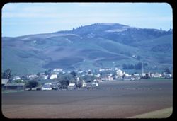
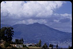
- Description:
- 100 f 4.5 TL
- Subject:
- Croplands, Streets, Hills, Agricultural machinery & implements, Mountains, Trees, Farms, Farming, and Houses
- Series:
- 2-60
- Creator:
- Cushman, Charles W., 1896-1972
- Date Created:
- 1960-03-10
- Genre:
- Cityscape photographs
- Frame Number:
- 16
- County:
- San Mateo
- Abstract:
- From ht wsw of tower
- Call Number:
- P10947
- City:
- Pescadero
- Country:
- United States
- State/Province:
- California
- Alternate Identifier:
- 260.16
- Persistent URL:
- http://purl.dlib.indiana.edu/iudl/archives/cushman/P10947
- Holding Location:
- Bloomington - University Archives
Wells Library E460
1320 E 10th St.
Bloomington, IN 47405
Contact at archives@indiana.edu, 812-855-1127
-
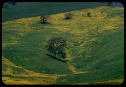
- Description:
- 100 f 8 TL
- Subject:
- Diablo, Mount (Calif.), Meadows, Flowers, Hills, Mustard (Plant), Mountains, Trees, Grasses, and Fences
- Series:
- 2-60
- Creator:
- Cushman, Charles W., 1896-1972
- Date Created:
- 1960-03-25
- Genre:
- Landscape photographs
- Frame Number:
- 28
- County:
- Contra Costa
- Abstract:
- Mustard & grass SE of Clayton
- Call Number:
- P10959
- City:
- Clayton
- Country:
- United States
- State/Province:
- California
- Alternate Identifier:
- 260.28
- Persistent URL:
- http://purl.dlib.indiana.edu/iudl/archives/cushman/P10959
- Holding Location:
- Bloomington - University Archives
Wells Library E460
1320 E 10th St.
Bloomington, IN 47405
Contact at archives@indiana.edu, 812-855-1127
-
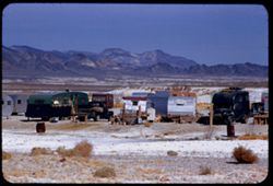
- Description:
- 100 f 8 + tl
- Subject:
- Minerals, Trucks, Valleys, Mountains, Shrubs, Tecopa Hot Springs (Calif.), and Trailers
- Series:
- 12-55
- Creator:
- Cushman, Charles W., 1896-1972
- Date Created:
- 1955-03-24
- Genre:
- Views
- Frame Number:
- 6
- County:
- Inyo
- Abstract:
- Trailer colony near Tecopa Hot Springs
- Call Number:
- P07902
- Country:
- United States
- State/Province:
- California
- Alternate Identifier:
- 1255.6
- Persistent URL:
- http://purl.dlib.indiana.edu/iudl/archives/cushman/P07902
- Holding Location:
- Bloomington - University Archives
Wells Library E460
1320 E 10th St.
Bloomington, IN 47405
Contact at archives@indiana.edu, 812-855-1127
-
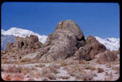
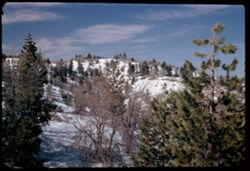
- Description:
- 100 f 5.6 tl
- Subject:
- Hills, Mountains, Sierra Nevada (Calif. and Nev.), Alabama Hills (Calif.), Rock formations, and Snow
- Series:
- 4-55
- Creator:
- Cushman, Charles W., 1896-1972
- Date Created:
- 1955-02-28
- Genre:
- Landscape photographs
- Frame Number:
- 4
- County:
- Inyo
- Abstract:
- In alabama Hills
- Call Number:
- P07632
- City:
- Lone Pine
- Country:
- United States
- State/Province:
- California
- Alternate Identifier:
- 455.4
- Persistent URL:
- http://purl.dlib.indiana.edu/iudl/archives/cushman/P07632
- Holding Location:
- Bloomington - University Archives
Wells Library E460
1320 E 10th St.
Bloomington, IN 47405
Contact at archives@indiana.edu, 812-855-1127
-
- Description:
- 25 f 8 Pola
- Subject:
- Lakes & ponds, Houses, Bodies of water, Sand, Mountains, Waterfronts, Trees, Beaches, Grasses, and Hills
- Series:
- 7-53
- Creator:
- Cushman, Charles W., 1896-1972
- Date Created:
- 1953-07-08
- Genre:
- Landscape photographs
- Frame Number:
- 29
- County:
- Marin
- Abstract:
- Across Bolinas lagoon from Bolinas.
- Call Number:
- P06753
- City:
- Bolinas
- Country:
- United States
- State/Province:
- California
- Alternate Identifier:
- 753.29
- Persistent URL:
- http://purl.dlib.indiana.edu/iudl/archives/cushman/P06753
- Holding Location:
- Bloomington - University Archives
Wells Library E460
1320 E 10th St.
Bloomington, IN 47405
Contact at archives@indiana.edu, 812-855-1127
-
- Description:
- 100 f 5.6 tl
- Subject:
- Valleys, Hills, Bodies of water, Roads, Mountains, Tamalpais, Mount (Calif.), Trees, Buildings, Clouds, Dwellings, and Utility poles
- Series:
- 5-55
- Creator:
- Cushman, Charles W., 1896-1972
- Date Created:
- 1955-03-10
- Genre:
- Landscape photographs
- Frame Number:
- 4
- County:
- Marin
- Abstract:
- Cloud mass above Mt. Tamalpais from top of Sausalito All of frame will next to 3
- Call Number:
- P07669
- City:
- Sausalito
- Country:
- United States
- State/Province:
- California
- Alternate Identifier:
- 555.4
- Persistent URL:
- http://purl.dlib.indiana.edu/iudl/archives/cushman/P07669
- Holding Location:
- Bloomington - University Archives
Wells Library E460
1320 E 10th St.
Bloomington, IN 47405
Contact at archives@indiana.edu, 812-855-1127
-
- Description:
- 25 f 8 pola
- Subject:
- San Bernardino Mountains (Calif.), Mountains, Snow, and Trees
- Series:
- 7-52
- Creator:
- Cushman, Charles W., 1896-1972
- Date Created:
- 1952-02-25
- Genre:
- Landscape photographs
- Frame Number:
- 29
- Street Address:
- Rim-of-World Drive
- Abstract:
- Snow clad mtns - from rim of World Drive
- Call Number:
- P05750
- Country:
- United States
- State/Province:
- California
- Alternate Identifier:
- 752.29
- Persistent URL:
- http://purl.dlib.indiana.edu/iudl/archives/cushman/P05750
- Holding Location:
- Bloomington - University Archives
Wells Library E460
1320 E 10th St.
Bloomington, IN 47405
Contact at archives@indiana.edu, 812-855-1127
-
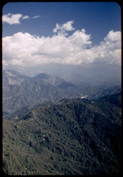
- Description:
- 25 f 5.6 pola
- Subject:
- Mount Wilson (Calif.), Mountains, Pines, Clouds, and San Gabriel Mountains (Calif.)
- Series:
- 6-52
- Creator:
- Cushman, Charles W., 1896-1972
- Date Created:
- 1952-02-18
- Genre:
- Landscape photographs
- Frame Number:
- 15
- County:
- Los Angeles
- Abstract:
- NE from Mt. Wilson
- Call Number:
- P05698
- Country:
- United States
- State/Province:
- California
- Alternate Identifier:
- 652.15
- Persistent URL:
- http://purl.dlib.indiana.edu/iudl/archives/cushman/P05698
- Holding Location:
- Bloomington - University Archives
Wells Library E460
1320 E 10th St.
Bloomington, IN 47405
Contact at archives@indiana.edu, 812-855-1127