
Search Constraints
You searched for:
Campus
IUB
Remove constraint Campus: IUB
Pages
0-99 pages
Remove constraint Pages: 0-99 pages
Subject
Mountains
Remove constraint Subject: Mountains
State/Province
Oregon
Remove constraint State/Province: Oregon
1 - 65 of 65
Search Results
-
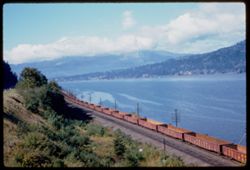
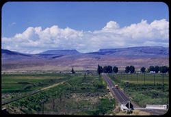
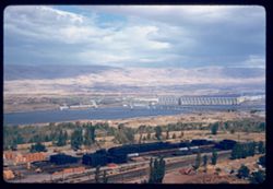
- Description:
- 50 f 6.3
- Subject:
- Railroad freight cars, Union Pacific Railroad Company, Columbia River, Railroad cars, Railroad tracks, Mountains, Utility poles, Electric lines, Trees, Cloud...
- Series:
- 25-60
- Creator:
- Cushman, Charles W., 1896-1972
- Date Created:
- 1960-09-25
- Genre:
- Landscape photographs
- Frame Number:
- 10
- County:
- Hood River
- Abstract:
- Cloud mass above Columbia 16 mi w. of H.R.
- Call Number:
- P11698
- City:
- Hood River
- Country:
- United States
- State/Province:
- Oregon
- Alternate Identifier:
- 2560.10
- Persistent URL:
- http://purl.dlib.indiana.edu/iudl/archives/cushman/P11698
- Holding Location:
- Bloomington - University Archives
Wells Library E460
1320 E 10th St.
Bloomington, IN 47405
Contact at archives@indiana.edu, 812-855-1127
-
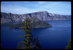
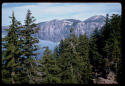
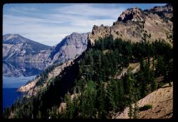
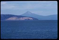
- Description:
- 100 f 8 sl
- Subject:
- Forests, Islands, Mountains, Tree limbs, Trees, Crater Lake (Or.), Cliffs, Lakes & ponds, and Wizard Island (Or.)
- Series:
- 23-60
- Creator:
- Cushman, Charles W., 1896-1972
- Date Created:
- 1960-09-16
- Genre:
- Landscape photographs
- Frame Number:
- 20
- County:
- Klamath
- Abstract:
- Wizard Isl.
- Call Number:
- P11641
- Country:
- United States
- State/Province:
- Oregon
- Alternate Identifier:
- 2360.20
- Persistent URL:
- http://purl.dlib.indiana.edu/iudl/archives/cushman/P11641
- Holding Location:
- Bloomington - University Archives
Wells Library E460
1320 E 10th St.
Bloomington, IN 47405
Contact at archives@indiana.edu, 812-855-1127
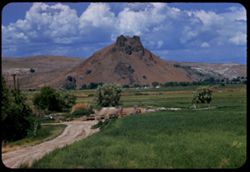
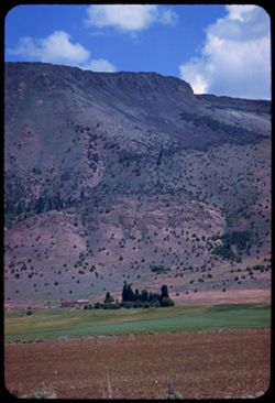
-
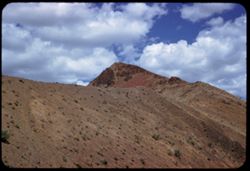
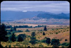
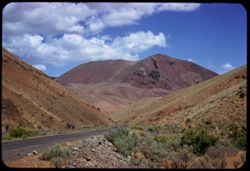
- Description:
- 100 f 6.3 SL
- Subject:
- Mountains, Shrubs, Rock formations, Malheur River (Or.), and Clouds
- Series:
- 11-58
- Creator:
- Cushman, Charles W., 1896-1972
- Date Created:
- 1958-06-14
- Genre:
- Landscape photographs
- Frame Number:
- 11
- County:
- Malheur
- Abstract:
- Tip of nearby
- Call Number:
- P09986
- Country:
- United States
- State/Province:
- Oregon
- Alternate Identifier:
- 1158.11
- Persistent URL:
- http://purl.dlib.indiana.edu/iudl/archives/cushman/P09986
- Holding Location:
- Bloomington - University Archives
Wells Library E460
1320 E 10th St.
Bloomington, IN 47405
Contact at archives@indiana.edu, 812-855-1127
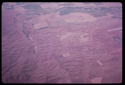
-
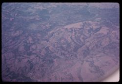
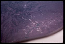
- Subject:
- Valleys, Air travel, and Mountains
- Series:
- 26-65
- Creator:
- Cushman, Charles W., 1896-1972
- Date Created:
- 1965-06-02
- Genre:
- Aerial photographs and Landscape photographs
- Frame Number:
- 7
- County:
- Malheur
- Call Number:
- P14768
- Country:
- United States
- State/Province:
- Oregon
- Alternate Identifier:
- 2565.7
- Persistent URL:
- http://purl.dlib.indiana.edu/iudl/archives/cushman/P14768
- Holding Location:
- Bloomington - University Archives
Wells Library E460
1320 E 10th St.
Bloomington, IN 47405
Contact at archives@indiana.edu, 812-855-1127
-
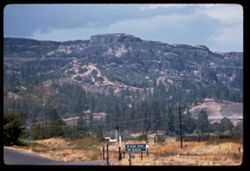
- Description:
- 100 f 4.5 tl
- Subject:
- Columbia River, Roads, Columbia River Palisades, Barbed wire, Trees, Signs (Notices), Mountains, Fences, Traffic signs & signals, Railroad tracks, Utilit...
- Series:
- 24-60
- Creator:
- Cushman, Charles W., 1896-1972
- Date Created:
- 1960-09-19
- Genre:
- Landscape photographs
- Frame Number:
- 11
- County:
- Wasco
- Abstract:
- Columbia palisades near Rowena
- Call Number:
- P11665
- City:
- Rowena
- Country:
- United States
- State/Province:
- Oregon
- Alternate Identifier:
- 2460.11
- Persistent URL:
- http://purl.dlib.indiana.edu/iudl/archives/cushman/P11665
- Holding Location:
- Bloomington - University Archives
Wells Library E460
1320 E 10th St.
Bloomington, IN 47405
Contact at archives@indiana.edu, 812-855-1127
-
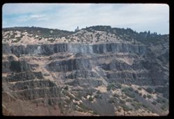
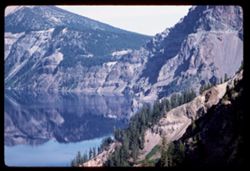
- Description:
- 100 f 6.3 tl
- Subject:
- Columbia River, Cliffs, Columbia River Palisades, Mountains, Shrubs, Columbia Palisades, and Rock formations
- Series:
- 24-60
- Creator:
- Cushman, Charles W., 1896-1972
- Date Created:
- 1960-09-19
- Genre:
- Landscape photographs
- Frame Number:
- 12
- County:
- Wasco
- Abstract:
- Palisades on right bank
- Call Number:
- P11666
- City:
- Rowena
- Country:
- United States
- State/Province:
- Oregon
- Alternate Identifier:
- 2460.12
- Persistent URL:
- http://purl.dlib.indiana.edu/iudl/archives/cushman/P11666
- Holding Location:
- Bloomington - University Archives
Wells Library E460
1320 E 10th St.
Bloomington, IN 47405
Contact at archives@indiana.edu, 812-855-1127
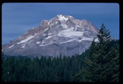
-
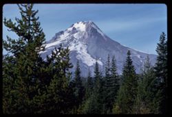
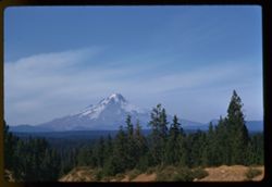
- Description:
- 100 f 8 tl
- Subject:
- Snow, Trees, Pines, Mountains, Hood, Mount (Or.), and Forests
- Series:
- 24-60
- Creator:
- Cushman, Charles W., 1896-1972
- Date Created:
- 1960-09-17
- Genre:
- Landscape photographs
- Frame Number:
- 6
- County:
- Clackamas
- Abstract:
- Top of Hood + top of pine
- Call Number:
- P11660
- Country:
- United States
- State/Province:
- Oregon
- Alternate Identifier:
- 2460.6
- Persistent URL:
- http://purl.dlib.indiana.edu/iudl/archives/cushman/P11660
- Holding Location:
- Bloomington - University Archives
Wells Library E460
1320 E 10th St.
Bloomington, IN 47405
Contact at archives@indiana.edu, 812-855-1127
-
- Description:
- 50 f 8 sl
- Subject:
- Columbia River, Trees, Tree limbs, Mountains, Shrubs, Clouds, and Rivers
- Series:
- 25-60
- Creator:
- Cushman, Charles W., 1896-1972
- Date Created:
- 1960-09-25
- Genre:
- Landscape photographs
- Frame Number:
- 9
- County:
- Hood River
- Abstract:
- Columbia, 12 mi west of Hood River
- Call Number:
- P11697
- City:
- Hood River
- Country:
- United States
- State/Province:
- Oregon
- Alternate Identifier:
- 2560.9
- Persistent URL:
- http://purl.dlib.indiana.edu/iudl/archives/cushman/P11697
- Holding Location:
- Bloomington - University Archives
Wells Library E460
1320 E 10th St.
Bloomington, IN 47405
Contact at archives@indiana.edu, 812-855-1127
-
- Description:
- 100 f 8 TL
- Subject:
- Roads, Automobiles, Trees, Mountains, Traffic signs & signals, Clouds, Railroad tracks, Utility poles, and Buses
- Series:
- 10-58
- Creator:
- Cushman, Charles W., 1896-1972
- Date Created:
- 1958-06-14
- Genre:
- Landscape photographs
- Frame Number:
- 36
- Street Address:
- United States Highway 20
- County:
- Malheur
- Abstract:
- West down US 20 toward Juntura
- Call Number:
- P09974
- City:
- Juntura
- Country:
- United States
- State/Province:
- Oregon
- Alternate Identifier:
- 1058.36
- Persistent URL:
- http://purl.dlib.indiana.edu/iudl/archives/cushman/P09974
- Holding Location:
- Bloomington - University Archives
Wells Library E460
1320 E 10th St.
Bloomington, IN 47405
Contact at archives@indiana.edu, 812-855-1127
-
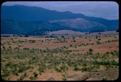
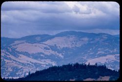
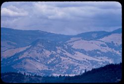
- Description:
- 100 f 5.6 tl
- Subject:
- Trees, Plains, Mountains, Shrubs, Clouds, Hills, and Plants
- Series:
- 10-56
- Creator:
- Cushman, Charles W., 1896-1972
- Date Created:
- 1956-07-13
- Genre:
- Landscape photographs
- Frame Number:
- 14
- County:
- Douglas
- Abstract:
- Country W. of Oakland
- Call Number:
- P08874
- City:
- Oakland
- Country:
- United States
- State/Province:
- Oregon
- Alternate Identifier:
- 1056.14
- Persistent URL:
- http://purl.dlib.indiana.edu/iudl/archives/cushman/P08874
- Holding Location:
- Bloomington - University Archives
Wells Library E460
1320 E 10th St.
Bloomington, IN 47405
Contact at archives@indiana.edu, 812-855-1127
-
- Subject:
- Valleys, Mountains, Air travel, Rivers, and Croplands
- Series:
- 26-65
- Creator:
- Cushman, Charles W., 1896-1972
- Date Created:
- 1965-06-02
- Genre:
- Aerial photographs and Landscape photographs
- Frame Number:
- 5
- Call Number:
- P14766
- Country:
- United States
- State/Province:
- Oregon
- Alternate Identifier:
- 2565.5
- Persistent URL:
- http://purl.dlib.indiana.edu/iudl/archives/cushman/P14766
- Holding Location:
- Bloomington - University Archives
Wells Library E460
1320 E 10th St.
Bloomington, IN 47405
Contact at archives@indiana.edu, 812-855-1127
-
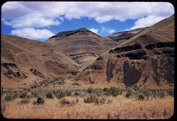
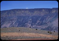
- Description:
- 100 f 6.3 SL
- Subject:
- Grasses, Volcanic rock, Mountains, Shrubs, and Clouds
- Series:
- 11-58
- Creator:
- Cushman, Charles W., 1896-1972
- Date Created:
- 1958-06-14
- Genre:
- Landscape photographs
- Frame Number:
- 5
- Street Address:
- United States Highway 20
- County:
- Malheur
- Abstract:
- Great brown lava
- Call Number:
- P09980
- Country:
- United States
- State/Province:
- Oregon
- Alternate Identifier:
- 1158.5
- Persistent URL:
- http://purl.dlib.indiana.edu/iudl/archives/cushman/P09980
- Holding Location:
- Bloomington - University Archives
Wells Library E460
1320 E 10th St.
Bloomington, IN 47405
Contact at archives@indiana.edu, 812-855-1127
-
- Description:
- 100 f 6.3 sl
- Subject:
- Cliffs, Trees, Crater Lake (Or.), Mountains, Lakes & ponds, and Reflections
- Series:
- 23-60
- Creator:
- Cushman, Charles W., 1896-1972
- Date Created:
- 1960-09-16
- Genre:
- Landscape photographs
- Frame Number:
- 21
- County:
- Klamath
- Abstract:
- Toward SE
- Call Number:
- P11642
- Country:
- United States
- State/Province:
- Oregon
- Alternate Identifier:
- 2360.21
- Persistent URL:
- http://purl.dlib.indiana.edu/iudl/archives/cushman/P11642
- Holding Location:
- Bloomington - University Archives
Wells Library E460
1320 E 10th St.
Bloomington, IN 47405
Contact at archives@indiana.edu, 812-855-1127
-
- Description:
- 100 f 4.5 tl
- Subject:
- Cliffs, Trees, Crater Lake (Or.), Phantom Ship (Or.), Mountains, Rock formations, Lakes & ponds, Islands, and Reflections
- Series:
- 23-60
- Creator:
- Cushman, Charles W., 1896-1972
- Date Created:
- 1960-09-16
- Genre:
- Landscape photographs
- Frame Number:
- 23
- County:
- Klamath
- Abstract:
- Phantom Ship
- Call Number:
- P11643
- Country:
- United States
- State/Province:
- Oregon
- Alternate Identifier:
- 2360.23
- Persistent URL:
- http://purl.dlib.indiana.edu/iudl/archives/cushman/P11643
- Holding Location:
- Bloomington - University Archives
Wells Library E460
1320 E 10th St.
Bloomington, IN 47405
Contact at archives@indiana.edu, 812-855-1127
-
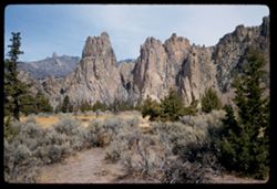
- Description:
- 50 f 9
- Subject:
- Cliffs, Trees, Buttes, Mountains, Rock formations, Smith Rock (Or.), and Shrubs
- Series:
- 23-60
- Creator:
- Cushman, Charles W., 1896-1972
- Date Created:
- 1960-09-17
- Genre:
- Landscape photographs
- Frame Number:
- 33
- County:
- Deschutes
- Abstract:
- Broad view of 29 + 30
- Call Number:
- P11652
- Country:
- United States
- State/Province:
- Oregon
- Alternate Identifier:
- 2360.33
- Persistent URL:
- http://purl.dlib.indiana.edu/iudl/archives/cushman/P11652
- Holding Location:
- Bloomington - University Archives
Wells Library E460
1320 E 10th St.
Bloomington, IN 47405
Contact at archives@indiana.edu, 812-855-1127
-
- Description:
- 100 f 5.6 sl
- Subject:
- Cliffs, Trees, Crater Lake (Or.), Phantom Ship (Or.), Mountains, Lakes & ponds, and Reflections
- Series:
- 23-60
- Creator:
- Cushman, Charles W., 1896-1972
- Date Created:
- 1960-09-16
- Genre:
- Landscape photographs
- Frame Number:
- 24
- County:
- Klamath
- Abstract:
- Phantom ship
- Call Number:
- P11644
- Country:
- United States
- State/Province:
- Oregon
- Alternate Identifier:
- 2360.24
- Persistent URL:
- http://purl.dlib.indiana.edu/iudl/archives/cushman/P11644
- Holding Location:
- Bloomington - University Archives
Wells Library E460
1320 E 10th St.
Bloomington, IN 47405
Contact at archives@indiana.edu, 812-855-1127
-
- Description:
- 50 f 8 sl
- Subject:
- Cliffs, Trees, Boulders, Mountains, Rock formations, and Smith Rock (Or.)
- Series:
- 23-60
- Creator:
- Cushman, Charles W., 1896-1972
- Date Created:
- 1960-09-17
- Genre:
- Landscape photographs
- Frame Number:
- 31
- County:
- Deschutes
- Call Number:
- P11650
- Country:
- United States
- State/Province:
- Oregon
- Alternate Identifier:
- 2360.31
- Persistent URL:
- http://purl.dlib.indiana.edu/iudl/archives/cushman/P11650
- Holding Location:
- Bloomington - University Archives
Wells Library E460
1320 E 10th St.
Bloomington, IN 47405
Contact at archives@indiana.edu, 812-855-1127
-
- Description:
- 100 f 8 TL
- Subject:
- Mountains, Shrubs, Malheur River (Or.), and Rivers
- Series:
- 10-58
- Creator:
- Cushman, Charles W., 1896-1972
- Date Created:
- 1958-06-14
- Genre:
- Landscape photographs
- Frame Number:
- 35
- County:
- Malheur
- Abstract:
- View down stream
- Call Number:
- P09973
- City:
- Juntura
- Country:
- United States
- State/Province:
- Oregon
- Alternate Identifier:
- 1058.35
- Persistent URL:
- http://purl.dlib.indiana.edu/iudl/archives/cushman/P09973
- Holding Location:
- Bloomington - University Archives
Wells Library E460
1320 E 10th St.
Bloomington, IN 47405
Contact at archives@indiana.edu, 812-855-1127
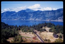
-
- Description:
- 50 f 8 sl
- Subject:
- Columbia River, Trees, Mountains, Buildings, Hills, Meredith Gorge Motel (Hood River, Or.), Reeds (Plants), and Rivers
- Series:
- 25-60
- Creator:
- Cushman, Charles W., 1896-1972
- Date Created:
- 1960-09-25
- Genre:
- Landscape photographs
- Frame Number:
- 7
- County:
- Hood River
- Abstract:
- Columbia river from our Motel (Meredith Gorge)
- Call Number:
- P11695
- City:
- Hood River
- Country:
- United States
- State/Province:
- Oregon
- Alternate Identifier:
- 2560.7
- Persistent URL:
- http://purl.dlib.indiana.edu/iudl/archives/cushman/P11695
- Holding Location:
- Bloomington - University Archives
Wells Library E460
1320 E 10th St.
Bloomington, IN 47405
Contact at archives@indiana.edu, 812-855-1127
-
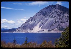
- Description:
- 100 f 6.3 tl
- Subject:
- Columbia River, Shadows, Mountains, Clouds, Hills, and Rivers
- Series:
- 25-60
- Creator:
- Cushman, Charles W., 1896-1972
- Date Created:
- 1960-09-24
- Genre:
- Landscape photographs
- Frame Number:
- 5
- County:
- Sherman
- Abstract:
- Up river from west of Biggs
- Call Number:
- P11693
- City:
- Biggs
- Country:
- United States
- State/Province:
- Oregon
- Alternate Identifier:
- 2560.5
- Persistent URL:
- http://purl.dlib.indiana.edu/iudl/archives/cushman/P11693
- Holding Location:
- Bloomington - University Archives
Wells Library E460
1320 E 10th St.
Bloomington, IN 47405
Contact at archives@indiana.edu, 812-855-1127
-
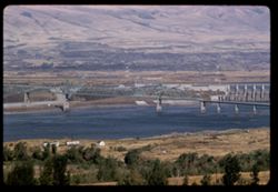
- Description:
- 100 f 8 sl
- Subject:
- Reservoirs, Columbia River bridge (Wasco County, Or.), Mountains, Clouds, Railroad tracks, Hills, Dams, Rivers, Columbia River, Bridges, and Dalles Dam (Or. ...
- Series:
- 24-60
- Creator:
- Cushman, Charles W., 1896-1972
- Date Created:
- 1960-09-19
- Genre:
- Views
- Frame Number:
- 15
- County:
- Wasco
- Abstract:
- Columbia river bridge alongside Dalles Dam
- Call Number:
- P11669
- City:
- Dalles
- Country:
- United States
- State/Province:
- Oregon
- Alternate Identifier:
- 2460.15
- Persistent URL:
- http://purl.dlib.indiana.edu/iudl/archives/cushman/P11669
- Holding Location:
- Bloomington - University Archives
Wells Library E460
1320 E 10th St.
Bloomington, IN 47405
Contact at archives@indiana.edu, 812-855-1127
-
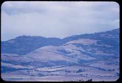
- Description:
- 100 f 5.6 tl
- Subject:
- Trees, Mountains, Shrubs, Hills, and Plants
- Series:
- 10-56
- Creator:
- Cushman, Charles W., 1896-1972
- Date Created:
- 1956-07-13
- Genre:
- Landscape photographs
- Frame Number:
- 12
- County:
- Douglas
- Abstract:
- Country NW of Oakland Douglas county
- Call Number:
- P08872
- City:
- Oakland
- Country:
- United States
- State/Province:
- Oregon
- Alternate Identifier:
- 1056.12
- Persistent URL:
- http://purl.dlib.indiana.edu/iudl/archives/cushman/P08872
- Holding Location:
- Bloomington - University Archives
Wells Library E460
1320 E 10th St.
Bloomington, IN 47405
Contact at archives@indiana.edu, 812-855-1127
-
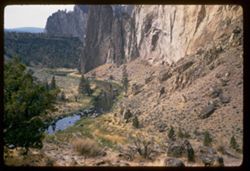
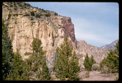
- Description:
- 50 f 6.3 sl
- Subject:
- Cliffs, Trees, Boulders, Buttes, Mountains, Shrubs, Smith Rock (Or.), Streams, and Rock formations
- Series:
- 23-60
- Creator:
- Cushman, Charles W., 1896-1972
- Date Created:
- 1960-09-17
- Genre:
- Landscape photographs
- Frame Number:
- 32
- County:
- Deschutes
- Abstract:
- Looking down into creek
- Call Number:
- P11651
- Country:
- United States
- State/Province:
- Oregon
- Alternate Identifier:
- 2360.32
- Persistent URL:
- http://purl.dlib.indiana.edu/iudl/archives/cushman/P11651
- Holding Location:
- Bloomington - University Archives
Wells Library E460
1320 E 10th St.
Bloomington, IN 47405
Contact at archives@indiana.edu, 812-855-1127
-
- Description:
- 100 f 9 tl
- Subject:
- Snow, Cascade Range, Trees, Mountains, Hood, Mount (Or.), Shrubs, Forests, and Hills
- Series:
- 24-60
- Creator:
- Cushman, Charles W., 1896-1972
- Date Created:
- 1960-09-17
- Genre:
- Landscape photographs
- Frame Number:
- 3
- County:
- Clackamas
- Abstract:
- Mt. Hood from south
- Call Number:
- P11658
- Country:
- United States
- State/Province:
- Oregon
- Alternate Identifier:
- 2460.3
- Persistent URL:
- http://purl.dlib.indiana.edu/iudl/archives/cushman/P11658
- Holding Location:
- Bloomington - University Archives
Wells Library E460
1320 E 10th St.
Bloomington, IN 47405
Contact at archives@indiana.edu, 812-855-1127
-
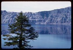
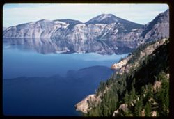
- Description:
- 100 f 5.6 tl
- Subject:
- Cliffs, Kerr Notch (Or.), Crater Lake (Or.), Tree limbs, Mountains, Lakes & ponds, Reflections, and Trees
- Series:
- 23-60
- Creator:
- Cushman, Charles W., 1896-1972
- Date Created:
- 1960-09-16
- Genre:
- Landscape photographs
- Frame Number:
- 13
- County:
- Klamath
- Abstract:
- Crater Lake from Kerr Notch
- Call Number:
- P11635
- Country:
- United States
- State/Province:
- Oregon
- Alternate Identifier:
- 2360.13
- Persistent URL:
- http://purl.dlib.indiana.edu/iudl/archives/cushman/P11635
- Holding Location:
- Bloomington - University Archives
Wells Library E460
1320 E 10th St.
Bloomington, IN 47405
Contact at archives@indiana.edu, 812-855-1127
-
- Description:
- 100 f 6.3 tl
- Subject:
- Cliffs, Crater Lake (Or.), Tree limbs, Mountains, Lakes & ponds, Forests, and Reflections
- Series:
- 23-60
- Creator:
- Cushman, Charles W., 1896-1972
- Date Created:
- 1960-09-16
- Genre:
- Landscape photographs
- Frame Number:
- 18
- County:
- Klamath
- Abstract:
- View SE
- Call Number:
- P11640
- Country:
- United States
- State/Province:
- Oregon
- Alternate Identifier:
- 2360.18
- Persistent URL:
- http://purl.dlib.indiana.edu/iudl/archives/cushman/P11640
- Holding Location:
- Bloomington - University Archives
Wells Library E460
1320 E 10th St.
Bloomington, IN 47405
Contact at archives@indiana.edu, 812-855-1127
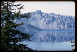
-
- Description:
- 50 f 6.3 sl
- Subject:
- Cliffs, Trees, Crater Lake (Or.), Tree limbs, Mountains, Lakes & ponds, Clouds, Islands, Reflections, and Kerr Notch (Or.)
- Series:
- 23-60
- Creator:
- Cushman, Charles W., 1896-1972
- Date Created:
- 1960-09-16
- Genre:
- Landscape photographs
- Frame Number:
- 15
- County:
- Klamath
- Abstract:
- Crater Lake from Kerr Notch
- Call Number:
- P11637
- Country:
- United States
- State/Province:
- Oregon
- Alternate Identifier:
- 2360.15
- Persistent URL:
- http://purl.dlib.indiana.edu/iudl/archives/cushman/P11637
- Holding Location:
- Bloomington - University Archives
Wells Library E460
1320 E 10th St.
Bloomington, IN 47405
Contact at archives@indiana.edu, 812-855-1127
-
- Description:
- 100 f 4 tl
- Subject:
- Cliffs, Kerr Notch (Or.), Crater Lake (Or.), Tree limbs, Mountains, Lakes & ponds, Reflections, and Trees
- Series:
- 23-60
- Creator:
- Cushman, Charles W., 1896-1972
- Date Created:
- 1960-09-16
- Genre:
- Landscape photographs
- Frame Number:
- 12
- County:
- Klamath
- Abstract:
- Crater Lake from Kerr Notch
- Call Number:
- P11634
- Country:
- United States
- State/Province:
- Oregon
- Alternate Identifier:
- 2360.12
- Persistent URL:
- http://purl.dlib.indiana.edu/iudl/archives/cushman/P11634
- Holding Location:
- Bloomington - University Archives
Wells Library E460
1320 E 10th St.
Bloomington, IN 47405
Contact at archives@indiana.edu, 812-855-1127
-
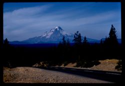
- Description:
- 100 f 11 tl
- Subject:
- Forests, Roads, Dirt, Mountains, Shrubs, Snow, Trees, and Hood, Mount (Or.)
- Series:
- 24-60
- Creator:
- Cushman, Charles W., 1896-1972
- Date Created:
- 1960-09-17
- Genre:
- Landscape photographs
- Frame Number:
- 4
- County:
- Clackamas
- Abstract:
- Mt. Hood from south
- Call Number:
- P11659
- Country:
- United States
- State/Province:
- Oregon
- Alternate Identifier:
- 2460.4
- Persistent URL:
- http://purl.dlib.indiana.edu/iudl/archives/cushman/P11659
- Holding Location:
- Bloomington - University Archives
Wells Library E460
1320 E 10th St.
Bloomington, IN 47405
Contact at archives@indiana.edu, 812-855-1127
-
- Description:
- 100 f 6.3 TL
- Subject:
- Rock formations, Mountains, Plants, Malheur River (Or.), Volcanic rock, and Clouds
- Series:
- 11-58
- Creator:
- Cushman, Charles W., 1896-1972
- Date Created:
- 1958-06-14
- Genre:
- Landscape photographs
- Frame Number:
- 13
- County:
- Malheur
- Abstract:
- Tip of nearby
- Call Number:
- P09988
- Country:
- United States
- State/Province:
- Oregon
- Alternate Identifier:
- 1158.13
- Persistent URL:
- http://purl.dlib.indiana.edu/iudl/archives/cushman/P09988
- Holding Location:
- Bloomington - University Archives
Wells Library E460
1320 E 10th St.
Bloomington, IN 47405
Contact at archives@indiana.edu, 812-855-1127
-
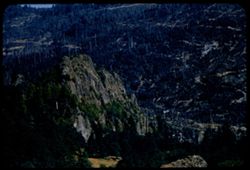
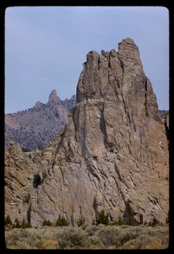
- Description:
- 50 f 8 sl
- Subject:
- Cliffs, Mountains, Trees, Smith Rock (Or.), and Rock formations
- Series:
- 24-60
- Creator:
- Cushman, Charles W., 1896-1972
- Date Created:
- 1960-09-17
- Genre:
- Identification photographs and Landscape photographs
- Frame Number:
- 1
- County:
- Deschutes
- Abstract:
- Smith Rocks = Monkey face
- Call Number:
- P11656
- Country:
- United States
- State/Province:
- Oregon
- Alternate Identifier:
- 2460.1
- Persistent URL:
- http://purl.dlib.indiana.edu/iudl/archives/cushman/P11656
- Holding Location:
- Bloomington - University Archives
Wells Library E460
1320 E 10th St.
Bloomington, IN 47405
Contact at archives@indiana.edu, 812-855-1127
-
- Description:
- 100 f 9 tl
- Subject:
- Forests, Cliffs, Mountains, Snow, Trees, and Hood, Mount (Or.)
- Series:
- 24-60
- Creator:
- Cushman, Charles W., 1896-1972
- Date Created:
- 1960-09-17
- Genre:
- Landscape photographs
- Frame Number:
- 7
- County:
- Clackamas
- Abstract:
- Mt Hood from sw roof
- Call Number:
- P11661
- Country:
- United States
- State/Province:
- Oregon
- Alternate Identifier:
- 2460.7
- Persistent URL:
- http://purl.dlib.indiana.edu/iudl/archives/cushman/P11661
- Holding Location:
- Bloomington - University Archives
Wells Library E460
1320 E 10th St.
Bloomington, IN 47405
Contact at archives@indiana.edu, 812-855-1127
-
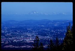
- Description:
- 100 f 8 tl
- Subject:
- Tree limbs, Hills, Mountains, Snow, Trees, Buildings, Cascade Range, and Hood, Mount (Or.)
- Series:
- 25-60
- Creator:
- Cushman, Charles W., 1896-1972
- Date Created:
- 1960-09-25
- Genre:
- Landscape photographs, Cityscape photographs, and Views
- Frame Number:
- 11
- Street Address:
- Council Crest Drive
- County:
- Multnomah
- Abstract:
- Toward Mt. Hood from Council Crest Dr.
- Call Number:
- P11699
- City:
- Portland
- Country:
- United States
- State/Province:
- Oregon
- Alternate Identifier:
- 2560.11
- Persistent URL:
- http://purl.dlib.indiana.edu/iudl/archives/cushman/P11699
- Holding Location:
- Bloomington - University Archives
Wells Library E460
1320 E 10th St.
Bloomington, IN 47405
Contact at archives@indiana.edu, 812-855-1127
-
- Description:
- 100 f 7 TL
- Subject:
- Mountains, Dirt roads, Trees, Plants, Rock formations, and Clouds
- Series:
- 11-58
- Creator:
- Cushman, Charles W., 1896-1972
- Date Created:
- 1958-06-14
- Genre:
- Landscape photographs
- Frame Number:
- 17
- Street Address:
- United States Highway 20
- County:
- Malheur
- Abstract:
- Rock like a pussy cat - east of Vale
- Call Number:
- P09992
- City:
- Vale
- Country:
- United States
- State/Province:
- Oregon
- Alternate Identifier:
- 1158.17
- Persistent URL:
- http://purl.dlib.indiana.edu/iudl/archives/cushman/P09992
- Holding Location:
- Bloomington - University Archives
Wells Library E460
1320 E 10th St.
Bloomington, IN 47405
Contact at archives@indiana.edu, 812-855-1127
-
- Description:
- 100 f 6 TL
- Subject:
- Volcanic rock, Mountains, and Plants
- Series:
- 10-58
- Creator:
- Cushman, Charles W., 1896-1972
- Date Created:
- 1958-06-13
- Genre:
- Landscape photographs
- Frame Number:
- 28
- County:
- Lake
- Abstract:
- Yellow on a dark lava ridge
- Call Number:
- P09967
- Country:
- United States
- State/Province:
- Oregon
- Alternate Identifier:
- 1058.28
- Persistent URL:
- http://purl.dlib.indiana.edu/iudl/archives/cushman/P09967
- Holding Location:
- Bloomington - University Archives
Wells Library E460
1320 E 10th St.
Bloomington, IN 47405
Contact at archives@indiana.edu, 812-855-1127
-
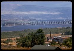
- Description:
- 100 f 8 tl
- Subject:
- Dalles Dam (Or. and Wash.), Hills, Columbia River, Bridges, Mountains, Utility poles, Electric lines, Reservoirs, Rivers, Dams, Hydraulic facilities, and Trees
- Series:
- 24-60
- Creator:
- Cushman, Charles W., 1896-1972
- Date Created:
- 1960-09-19
- Genre:
- Landscape photographs and Views
- Frame Number:
- 13
- County:
- Wasco
- Abstract:
- The Dalles Dam
- Call Number:
- P11667
- City:
- Dalles
- Country:
- United States
- State/Province:
- Oregon
- Alternate Identifier:
- 2460.13
- Persistent URL:
- http://purl.dlib.indiana.edu/iudl/archives/cushman/P11667
- Holding Location:
- Bloomington - University Archives
Wells Library E460
1320 E 10th St.
Bloomington, IN 47405
Contact at archives@indiana.edu, 812-855-1127
-
- Description:
- 100 f 8 TL
- Subject:
- Agriculture, Mountains, Trees, Plants, Rock formations, Hills, and Clouds
- Series:
- 11-58
- Creator:
- Cushman, Charles W., 1896-1972
- Date Created:
- 1958-06-14
- Genre:
- Landscape photographs
- Frame Number:
- 18
- Street Address:
- United States Highway 20
- County:
- Malheur
- Abstract:
- Rock like a pussy cat - east of Vale
- Call Number:
- P09993
- City:
- Vale
- Country:
- United States
- State/Province:
- Oregon
- Alternate Identifier:
- 1158.18
- Persistent URL:
- http://purl.dlib.indiana.edu/iudl/archives/cushman/P09993
- Holding Location:
- Bloomington - University Archives
Wells Library E460
1320 E 10th St.
Bloomington, IN 47405
Contact at archives@indiana.edu, 812-855-1127
-
- Description:
- 100 f 5 TL
- Subject:
- Hills, Mountains, Shrubs, Trees, and Clouds
- Series:
- 10-58
- Creator:
- Cushman, Charles W., 1896-1972
- Date Created:
- 1958-06-13
- Genre:
- Landscape photographs
- Frame Number:
- 26
- County:
- Lake
- Abstract:
- Hill & lava ridge
- Call Number:
- P09965
- Country:
- United States
- State/Province:
- Oregon
- Alternate Identifier:
- 1058.26
- Persistent URL:
- http://purl.dlib.indiana.edu/iudl/archives/cushman/P09965
- Holding Location:
- Bloomington - University Archives
Wells Library E460
1320 E 10th St.
Bloomington, IN 47405
Contact at archives@indiana.edu, 812-855-1127
-
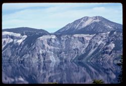
- Description:
- 100 f 8 tl
- Subject:
- Lakes & ponds, Reflections, Thielsen, Mount (Or.), Forests, Cliffs, Mountains, and Crater Lake (Or.)
- Series:
- 23-60
- Creator:
- Cushman, Charles W., 1896-1972
- Date Created:
- 1960-09-16
- Genre:
- Landscape photographs
- Frame Number:
- 16
- County:
- Klamath
- Abstract:
- Toward Mt. Thielsen
- Call Number:
- P11638
- Country:
- United States
- State/Province:
- Oregon
- Alternate Identifier:
- 2360.16
- Persistent URL:
- http://purl.dlib.indiana.edu/iudl/archives/cushman/P11638
- Holding Location:
- Bloomington - University Archives
Wells Library E460
1320 E 10th St.
Bloomington, IN 47405
Contact at archives@indiana.edu, 812-855-1127
-
- Description:
- 50 f 5.6 sl
- Subject:
- Lakes & ponds, Tree limbs, Reflections, Kerr Notch (Or.), Cliffs, Mountains, Trees, Islands, Crater Lake (Or.), and Mosses
- Series:
- 23-60
- Creator:
- Cushman, Charles W., 1896-1972
- Date Created:
- 1960-09-16
- Genre:
- Landscape photographs
- Frame Number:
- 14
- County:
- Klamath
- Abstract:
- Crater Lake from Kerr Notch
- Call Number:
- P11636
- Country:
- United States
- State/Province:
- Oregon
- Alternate Identifier:
- 2360.14
- Persistent URL:
- http://purl.dlib.indiana.edu/iudl/archives/cushman/P11636
- Holding Location:
- Bloomington - University Archives
Wells Library E460
1320 E 10th St.
Bloomington, IN 47405
Contact at archives@indiana.edu, 812-855-1127
-
- Description:
- 100 f 6.3 tl
- Subject:
- Lumber industry, Mountains, Trees, and Forests
- Series:
- 9-56
- Creator:
- Cushman, Charles W., 1896-1972
- Date Created:
- 1956-07-10
- Genre:
- Landscape photographs
- Frame Number:
- 7
- Street Address:
- United States Highway 101
- County:
- Curry
- Abstract:
- Logged-out mtn sides 43 in north of Crescent City on US 101- near Carpenterville, Curry co., Oregon
- Call Number:
- P08829
- City:
- Carpenterville
- Country:
- United States
- State/Province:
- Oregon
- Alternate Identifier:
- 956.7
- Persistent URL:
- http://purl.dlib.indiana.edu/iudl/archives/cushman/P08829
- Holding Location:
- Bloomington - University Archives
Wells Library E460
1320 E 10th St.
Bloomington, IN 47405
Contact at archives@indiana.edu, 812-855-1127
-
- Description:
- 100 f 5.6 tl
- Subject:
- Sandbars, Industrial facilities, Hills, Bodies of water, Mountains, Shrubs, Buildings, Islands, and Houses
- Series:
- 23-60
- Creator:
- Cushman, Charles W., 1896-1972
- Date Created:
- 1960-09-16
- Genre:
- Landscape photographs, Cityscape photographs, and Views
- Frame Number:
- 10
- County:
- Klamath
- Abstract:
- Klamath Falls from south
- Call Number:
- P11632
- City:
- Klamath Falls
- Country:
- United States
- State/Province:
- Oregon
- Alternate Identifier:
- 2360.10
- Persistent URL:
- http://purl.dlib.indiana.edu/iudl/archives/cushman/P11632
- Holding Location:
- Bloomington - University Archives
Wells Library E460
1320 E 10th St.
Bloomington, IN 47405
Contact at archives@indiana.edu, 812-855-1127
-
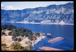
- Description:
- 50 f 6.3 sl
- Subject:
- Logs, Hills, Lumber industry, Columbia River, Meredith Gorge Motel (Hood River, Or.), Mountains, Trees, Buildings, and Rivers
- Series:
- 25-60
- Creator:
- Cushman, Charles W., 1896-1972
- Date Created:
- 1960-09-25
- Genre:
- Landscape photographs
- Frame Number:
- 6
- County:
- Hood River
- Abstract:
- Columbia river from our Motel (Meredith Gorge)
- Call Number:
- P11694
- City:
- Hood River
- Country:
- United States
- State/Province:
- Oregon
- Alternate Identifier:
- 2560.6
- Persistent URL:
- http://purl.dlib.indiana.edu/iudl/archives/cushman/P11694
- Holding Location:
- Bloomington - University Archives
Wells Library E460
1320 E 10th St.
Bloomington, IN 47405
Contact at archives@indiana.edu, 812-855-1127
-
- Description:
- 50 f 8 sl
- Subject:
- Columbia River, Roads, Meredith Gorge Motel (Hood River, Or.), Bridges, Railroad tracks, Mountains, Utility poles, Trees, Buildings, Rivers, and Clouds
- Series:
- 25-60
- Creator:
- Cushman, Charles W., 1896-1972
- Date Created:
- 1960-09-25
- Genre:
- Landscape photographs
- Frame Number:
- 8
- County:
- Hood River
- Call Number:
- P11696
- City:
- Hood River
- Country:
- United States
- State/Province:
- Oregon
- Alternate Identifier:
- 2560.8
- Persistent URL:
- http://purl.dlib.indiana.edu/iudl/archives/cushman/P11696
- Holding Location:
- Bloomington - University Archives
Wells Library E460
1320 E 10th St.
Bloomington, IN 47405
Contact at archives@indiana.edu, 812-855-1127
-
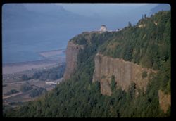
- Description:
- 100 f 5.6 tl
- Subject:
- Forests, Columbia River, Roads, Cliffs, Bridges, Mountains, Trees, Buildings, Cascade Range, Rivers, Crown Point (Multnomah County, Or.), and Scenic overlooks
- Series:
- 24-60
- Creator:
- Cushman, Charles W., 1896-1972
- Date Created:
- 1960-09-18
- Frame Number:
- 10
- County:
- Multnomah
- Abstract:
- Crown Point above Columbia river, from west
- Call Number:
- P11664
- Country:
- United States
- State/Province:
- Oregon
- Alternate Identifier:
- 2460.10
- Persistent URL:
- http://purl.dlib.indiana.edu/iudl/archives/cushman/P11664
- Holding Location:
- Bloomington - University Archives
Wells Library E460
1320 E 10th St.
Bloomington, IN 47405
Contact at archives@indiana.edu, 812-855-1127
-
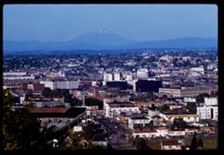
- Description:
- 100 f 8 tl
- Subject:
- Saint Helens, Mount (Wash.), Cities & towns, Streets, Mountains, Utility poles, Snow, Commercial facilities, Portland Electric & Plumbing Company (Po...
- Series:
- 25-60
- Creator:
- Cushman, Charles W., 1896-1972
- Date Created:
- 1960-09-25
- Genre:
- Cityscape photographs
- Frame Number:
- 15
- County:
- Multnomah
- Abstract:
- Toward Mt St Helens
- Call Number:
- P11703
- City:
- Portland
- Country:
- United States
- State/Province:
- Oregon
- Alternate Identifier:
- 2560.15
- Persistent URL:
- http://purl.dlib.indiana.edu/iudl/archives/cushman/P11703
- Holding Location:
- Bloomington - University Archives
Wells Library E460
1320 E 10th St.
Bloomington, IN 47405
Contact at archives@indiana.edu, 812-855-1127
-
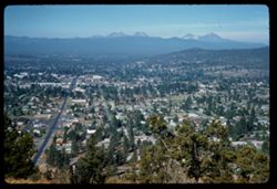
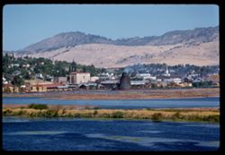
- Description:
- 50 f 8 sl
- Subject:
- Tree limbs, Cities & towns, Streets, Pilot Butte (Deschutes County, Or.), Mountains, Trees, Buildings, Cascade Range, and Houses
- Series:
- 23-60
- Creator:
- Cushman, Charles W., 1896-1972
- Date Created:
- 1960-09-17
- Genre:
- Cityscape photographs
- Frame Number:
- 27
- County:
- Deschutes
- Abstract:
- Bend. from top of Pilot Butte
- Call Number:
- P11647
- City:
- Bend
- Country:
- United States
- State/Province:
- Oregon
- Alternate Identifier:
- 2360.27
- Persistent URL:
- http://purl.dlib.indiana.edu/iudl/archives/cushman/P11647
- Holding Location:
- Bloomington - University Archives
Wells Library E460
1320 E 10th St.
Bloomington, IN 47405
Contact at archives@indiana.edu, 812-855-1127
-
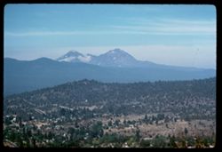
- Description:
- 100 f 5.6 sl
- Subject:
- Hills, Forests, Roads, Mountains, Trees, Buildings, and Pilot Butte (Deschutes County, Or.)
- Series:
- 23-60
- Creator:
- Cushman, Charles W., 1896-1972
- Date Created:
- 1960-09-17
- Genre:
- Landscape photographs
- Frame Number:
- 28
- County:
- Deschutes
- Abstract:
- Mtns. West of Bend Sisters
- Call Number:
- P11648
- City:
- Bend and Sisters
- Country:
- United States
- State/Province:
- Oregon
- Alternate Identifier:
- 2360.28
- Persistent URL:
- http://purl.dlib.indiana.edu/iudl/archives/cushman/P11648
- Holding Location:
- Bloomington - University Archives
Wells Library E460
1320 E 10th St.
Bloomington, IN 47405
Contact at archives@indiana.edu, 812-855-1127
-
- Description:
- 100 f 6.3 TL
- Subject:
- Canyons, Mountains, Clouds, Malheur River (Or.), and Plants
- Series:
- 11-58
- Creator:
- Cushman, Charles W., 1896-1972
- Date Created:
- 1958-06-14
- Genre:
- Landscape photographs
- Frame Number:
- 12
- County:
- Malheur and Harney
- Abstract:
- Great red hunk
- Call Number:
- P09987
- City:
- Burns
- Country:
- United States
- State/Province:
- Oregon
- Alternate Identifier:
- 1158.12
- Persistent URL:
- http://purl.dlib.indiana.edu/iudl/archives/cushman/P09987
- Holding Location:
- Bloomington - University Archives
Wells Library E460
1320 E 10th St.
Bloomington, IN 47405
Contact at archives@indiana.edu, 812-855-1127
-
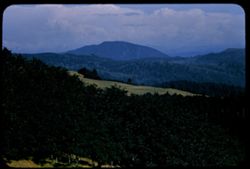
- Description:
- 100 f 4.5 tl
- Subject:
- Farms, Trees, Mountains, and Clouds
- Series:
- 10-56
- Creator:
- Cushman, Charles W., 1896-1972
- Date Created:
- 1956-07-13
- Genre:
- Landscape photographs
- Frame Number:
- 16
- Street Address:
- United States Highway 99
- County:
- Jackson
- Abstract:
- View east from US 99 between Medford & Ashland
- Call Number:
- P08876
- City:
- Phoenix and Medford
- Country:
- United States
- State/Province:
- Oregon
- Alternate Identifier:
- 1056.16
- Persistent URL:
- http://purl.dlib.indiana.edu/iudl/archives/cushman/P08876
- Holding Location:
- Bloomington - University Archives
Wells Library E460
1320 E 10th St.
Bloomington, IN 47405
Contact at archives@indiana.edu, 812-855-1127
-
- Description:
- 100 f 8 TL
- Subject:
- Malheur River Valley (Or.), Valleys, Mountains, Clouds, Hills, and Plants
- Series:
- 10-58
- Creator:
- Cushman, Charles W., 1896-1972
- Date Created:
- 1958-06-14
- Genre:
- Landscape photographs
- Frame Number:
- 31
- Street Address:
- United States Highway 20
- County:
- Harney
- Abstract:
- West down US 20 across Malheur river
- Call Number:
- P09970
- City:
- Burns
- Country:
- United States
- State/Province:
- Oregon
- Alternate Identifier:
- 1058.31
- Persistent URL:
- http://purl.dlib.indiana.edu/iudl/archives/cushman/P09970
- Holding Location:
- Bloomington - University Archives
Wells Library E460
1320 E 10th St.
Bloomington, IN 47405
Contact at archives@indiana.edu, 812-855-1127
-
- Description:
- 100 f 8 TL
- Subject:
- Malheur River Valley (Or.), Valleys, Mountains, Clouds, Hills, and Plants
- Series:
- 10-58
- Creator:
- Cushman, Charles W., 1896-1972
- Date Created:
- 1958-06-14
- Genre:
- Landscape photographs
- Frame Number:
- 30
- County:
- Harney
- Abstract:
- Ranches in Malheur river valley seen from east height
- Call Number:
- P09969
- City:
- Burns
- Country:
- United States
- State/Province:
- Oregon
- Alternate Identifier:
- 1058.30
- Persistent URL:
- http://purl.dlib.indiana.edu/iudl/archives/cushman/P09969
- Holding Location:
- Bloomington - University Archives
Wells Library E460
1320 E 10th St.
Bloomington, IN 47405
Contact at archives@indiana.edu, 812-855-1127
-
- Subject:
- Valleys, Mountains, Air travel, Windows, and Rivers
- Series:
- 26-65
- Creator:
- Cushman, Charles W., 1896-1972
- Date Created:
- 1965-06-02
- Genre:
- Aerial photographs and Landscape photographs
- Frame Number:
- 8
- County:
- Malheur
- Call Number:
- P14769
- Country:
- United States
- State/Province:
- Oregon
- Alternate Identifier:
- 2665.8
- Persistent URL:
- http://purl.dlib.indiana.edu/iudl/archives/cushman/P14769
- Holding Location:
- Bloomington - University Archives
Wells Library E460
1320 E 10th St.
Bloomington, IN 47405
Contact at archives@indiana.edu, 812-855-1127
-
- Description:
- 100 f6 tl
- Subject:
- Ranches, Volcanic rock, Trees, Mountains, and Clouds
- Series:
- 10-58
- Creator:
- Cushman, Charles W., 1896-1972
- Date Created:
- 1958-06-13
- Genre:
- Landscape photographs
- Frame Number:
- 27
- County:
- Lake
- Abstract:
- Ranch below lava ridge
- Call Number:
- P09966
- Country:
- United States
- State/Province:
- Oregon
- Alternate Identifier:
- 1058.27
- Persistent URL:
- http://purl.dlib.indiana.edu/iudl/archives/cushman/P09966
- Holding Location:
- Bloomington - University Archives
Wells Library E460
1320 E 10th St.
Bloomington, IN 47405
Contact at archives@indiana.edu, 812-855-1127
-
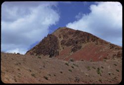
- Description:
- 100 f 8 tl
- Subject:
- Cliffs, Buttes, Mountains, Rock formations, Smith Rock (Or.), and Shrubs
- Series:
- 23-60
- Creator:
- Cushman, Charles W., 1896-1972
- Date Created:
- 1960-09-17
- Genre:
- Landscape photographs and Identification photographs
- Frame Number:
- 29
- County:
- Deschutes
- Call Number:
- P11649
- City:
- Terrebonne
- Country:
- United States
- State/Province:
- Oregon
- Alternate Identifier:
- 2360.29
- Persistent URL:
- http://purl.dlib.indiana.edu/iudl/archives/cushman/P11649
- Holding Location:
- Bloomington - University Archives
Wells Library E460
1320 E 10th St.
Bloomington, IN 47405
Contact at archives@indiana.edu, 812-855-1127
-
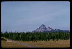
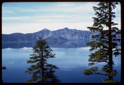
- Description:
- 100 f 8 tl
- Subject:
- Trestles, Roads, Automobiles, Crater Lake (Or.), Thielsen, Mount (Or.), Plains, Mountains, and Forests
- Series:
- 23-60
- Creator:
- Cushman, Charles W., 1896-1972
- Date Created:
- 1960-09-16
- Genre:
- Landscape photographs
- Frame Number:
- 26
- County:
- Klamath
- Abstract:
- Mt Thiesen
- Call Number:
- P11646
- Country:
- United States
- State/Province:
- Oregon
- Alternate Identifier:
- 2360.26
- Persistent URL:
- http://purl.dlib.indiana.edu/iudl/archives/cushman/P11646
- Holding Location:
- Bloomington - University Archives
Wells Library E460
1320 E 10th St.
Bloomington, IN 47405
Contact at archives@indiana.edu, 812-855-1127
-
- Description:
- 100 f 6.3 sl
- Subject:
- Cliffs, Trees, Crater Lake (Or.), Mountains, Rock formations, Lakes & ponds, Forests, and Reflections
- Series:
- 23-60
- Creator:
- Cushman, Charles W., 1896-1972
- Date Created:
- 1960-09-16
- Genre:
- Landscape photographs
- Frame Number:
- 25
- County:
- Klamath
- Abstract:
- Garfield Dock
- Call Number:
- P11645
- Country:
- United States
- State/Province:
- Oregon
- Alternate Identifier:
- 2360.25
- Persistent URL:
- http://purl.dlib.indiana.edu/iudl/archives/cushman/P11645
- Holding Location:
- Bloomington - University Archives
Wells Library E460
1320 E 10th St.
Bloomington, IN 47405
Contact at archives@indiana.edu, 812-855-1127
-
- Description:
- 100 f 5.6 tl
- Subject:
- Siskiyou Mountains (Calif. and Or.), Trees, Mountains, and Clouds
- Series:
- 10-56
- Creator:
- Cushman, Charles W., 1896-1972
- Date Created:
- 1956-07-13
- Genre:
- Landscape photographs
- Frame Number:
- 18
- Street Address:
- United States Highway 99
- County:
- Jackson
- Abstract:
- Siskiyou Mtns. Jackson county
- Call Number:
- P08878
- Country:
- United States
- State/Province:
- Oregon
- Alternate Identifier:
- 1056.18
- Persistent URL:
- http://purl.dlib.indiana.edu/iudl/archives/cushman/P08878
- Holding Location:
- Bloomington - University Archives
Wells Library E460
1320 E 10th St.
Bloomington, IN 47405
Contact at archives@indiana.edu, 812-855-1127
-
- Description:
- 100 f 8 tl
- Subject:
- Hydraulic facilities, Reservoirs, Trees, Mountains, Bridges, Hills, Dams, Dalles Dam (Or. and Wash.), Columbia River, and Rivers
- Series:
- 24-60
- Creator:
- Cushman, Charles W., 1896-1972
- Date Created:
- 1960-09-19
- Genre:
- Views
- Frame Number:
- 14
- County:
- Wasco
- Abstract:
- Columbia river bridge alongside Dalles Dam
- Call Number:
- P11668
- City:
- Dalles
- Country:
- United States
- State/Province:
- Oregon
- Alternate Identifier:
- 2460.14
- Persistent URL:
- http://purl.dlib.indiana.edu/iudl/archives/cushman/P11668
- Holding Location:
- Bloomington - University Archives
Wells Library E460
1320 E 10th St.
Bloomington, IN 47405
Contact at archives@indiana.edu, 812-855-1127
-
- Description:
- 100 f 8 tl
- Subject:
- Trees, Meadows, Mountains, Clouds, Forests, and Hills
- Series:
- 9-56
- Creator:
- Cushman, Charles W., 1896-1972
- Date Created:
- 1956-07-10
- Genre:
- Landscape photographs
- Frame Number:
- 8
- Street Address:
- United States Highway 101
- County:
- Curry
- Abstract:
- north of Crescent City on US 101- near Carpenterville, Curry co., Oregon view se - toward large mtn
- Call Number:
- P08830
- City:
- Carpenterville
- Country:
- United States
- State/Province:
- Oregon
- Alternate Identifier:
- 956.8
- Persistent URL:
- http://purl.dlib.indiana.edu/iudl/archives/cushman/P08830
- Holding Location:
- Bloomington - University Archives
Wells Library E460
1320 E 10th St.
Bloomington, IN 47405
Contact at archives@indiana.edu, 812-855-1127
-
- Description:
- 100 f 6.3 SL
- Subject:
- Rocks, Canyons, Roads, Malheur Canyon (Or.), Volcanic rock, Mountains, Shrubs, and Clouds
- Series:
- 11-58
- Creator:
- Cushman, Charles W., 1896-1972
- Date Created:
- 1958-06-14
- Genre:
- Landscape photographs
- Frame Number:
- 10
- County:
- Malheur and Harney
- Abstract:
- Great red hunk
- Call Number:
- P09985
- City:
- Burns
- Country:
- United States
- State/Province:
- Oregon
- Alternate Identifier:
- 1158.10
- Persistent URL:
- http://purl.dlib.indiana.edu/iudl/archives/cushman/P09985
- Holding Location:
- Bloomington - University Archives
Wells Library E460
1320 E 10th St.
Bloomington, IN 47405
Contact at archives@indiana.edu, 812-855-1127
-
- Description:
- 100 f 6.3 tl
- Subject:
- Mountains, Lakes & ponds, Upper Klamath Lake (Or.), Forests, Hills, and McLoughlin, Mount (Or.)
- Series:
- 23-60
- Creator:
- Cushman, Charles W., 1896-1972
- Date Created:
- 1960-09-16
- Genre:
- Landscape photographs and Seascapes
- Frame Number:
- 11
- County:
- Klamath
- Abstract:
- McLoughlin Mtn Pk seen across upper Klamuth Lake
- Call Number:
- P11633
- Country:
- United States
- State/Province:
- Oregon
- Alternate Identifier:
- 2360.11
- Persistent URL:
- http://purl.dlib.indiana.edu/iudl/archives/cushman/P11633
- Holding Location:
- Bloomington - University Archives
Wells Library E460
1320 E 10th St.
Bloomington, IN 47405
Contact at archives@indiana.edu, 812-855-1127
-
- Description:
- 100 f 5.6 tl
- Subject:
- Siskiyou Mountains (Calif. and Or.), Trees, Mountains, and Clouds
- Series:
- 10-56
- Creator:
- Cushman, Charles W., 1896-1972
- Date Created:
- 1956-07-13
- Genre:
- Landscape photographs
- Frame Number:
- 19
- County:
- Jackson
- Abstract:
- Siskiyou Mtns. Jackson county
- Call Number:
- P08879
- Country:
- United States
- State/Province:
- Oregon
- Alternate Identifier:
- 1056.19
- Persistent URL:
- http://purl.dlib.indiana.edu/iudl/archives/cushman/P08879
- Holding Location:
- Bloomington - University Archives
Wells Library E460
1320 E 10th St.
Bloomington, IN 47405
Contact at archives@indiana.edu, 812-855-1127
-
- Description:
- 100 f 4 tl
- Subject:
- Trees, Mountains, and Clouds
- Series:
- 10-56
- Creator:
- Cushman, Charles W., 1896-1972
- Date Created:
- 1956-07-13
- Genre:
- Landscape photographs
- Frame Number:
- 17
- County:
- Jackson
- Abstract:
- Mtns. north of Ashland
- Call Number:
- P08877
- City:
- Ashland
- Country:
- United States
- State/Province:
- Oregon
- Alternate Identifier:
- 1056.17
- Persistent URL:
- http://purl.dlib.indiana.edu/iudl/archives/cushman/P08877
- Holding Location:
- Bloomington - University Archives
Wells Library E460
1320 E 10th St.
Bloomington, IN 47405
Contact at archives@indiana.edu, 812-855-1127
-

- Description:
- 100 f 6.3 tl
- Subject:
- Rogue River (Or.), Cliffs, Lumberyards, Meadows, Mountains, Fences, Lumber industry, Logs, Hills, and Grasses
- Series:
- 25-60
- Creator:
- Cushman, Charles W., 1896-1972
- Date Created:
- 1960-09-26
- Genre:
- Landscape photographs
- Frame Number:
- 16
- County:
- Jackson
- Abstract:
- Rock bluff above Rogue river
- Call Number:
- P11704
- City:
- Medford
- Country:
- United States
- State/Province:
- Oregon
- Alternate Identifier:
- 2560.16
- Persistent URL:
- http://purl.dlib.indiana.edu/iudl/archives/cushman/P11704
- Holding Location:
- Bloomington - University Archives
Wells Library E460
1320 E 10th St.
Bloomington, IN 47405
Contact at archives@indiana.edu, 812-855-1127