
Search Constraints
You searched for:
Campus
IUB
Remove constraint Campus: IUB
Pages
0-99 pages
Remove constraint Pages: 0-99 pages
Subject
Mountains
Remove constraint Subject: Mountains
State/Province
Texas
Remove constraint State/Province: Texas
« Previous |
1 - 20 of 71
|
Next »
Search Results
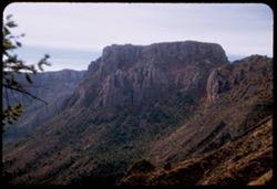
-
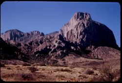
- Description:
- 25 f 11
- Subject:
- National parks & reserves, Pulliam Peak (Tex.), Green Gulch (Tex.), Valleys, Cliffs, Big Bend National Park (Tex.), Mountains, Shrubs, Basin (Big Bend Na...
- Series:
- 16-51
- Creator:
- Cushman, Charles W., 1896-1972
- Date Created:
- 1951-12-27
- Genre:
- Landscape photographs
- Frame Number:
- 4
- County:
- Brewster
- Abstract:
- Great bold front of Pulliam Pk. from Green gulch
- Call Number:
- P05423
- Country:
- United States
- State/Province:
- Texas
- Alternate Identifier:
- 1651.4
- Persistent URL:
- http://purl.dlib.indiana.edu/iudl/archives/cushman/P05423
- Holding Location:
- Bloomington - University Archives
Wells Library E460
1320 E 10th St.
Bloomington, IN 47405
Contact at archives@indiana.edu, 812-855-1127
-
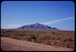
- Description:
- 50 f 8
- Subject:
- Plains, Mountains, Dirt roads, Shrubs, Sierra Blanca Mountains (Tex.), and Grasses
- Series:
- 12-53
- Creator:
- Cushman, Charles W., 1896-1972
- Date Created:
- 1953-11-15
- Genre:
- Landscape photographs
- Frame Number:
- 36
- County:
- Hudspeth
- Abstract:
- Sierra Blanca Mtn. (7000 ft)
- Call Number:
- P06954
- City:
- Sierra Blanca
- Country:
- United States
- State/Province:
- Texas
- Alternate Identifier:
- 1253.36
- Persistent URL:
- http://purl.dlib.indiana.edu/iudl/archives/cushman/P06954
- Holding Location:
- Bloomington - University Archives
Wells Library E460
1320 E 10th St.
Bloomington, IN 47405
Contact at archives@indiana.edu, 812-855-1127
-
- Description:
- 50 f 8
- Subject:
- Hills, Roads, Franklin Mountains (Tex. and N.M.), Mountains, Shrubs, Shadows, and Clouds
- Series:
- 17-51
- Creator:
- Cushman, Charles W., 1896-1972
- Date Created:
- 1952-01-01
- Genre:
- Landscape photographs
- Frame Number:
- 30
- County:
- El Paso
- Abstract:
- Whorls on a Mtn. side = Franklin Mtns.
- Call Number:
- P05481
- City:
- El Paso
- Country:
- United States
- State/Province:
- Texas
- Alternate Identifier:
- 1751.30
- Persistent URL:
- http://purl.dlib.indiana.edu/iudl/archives/cushman/P05481
- Holding Location:
- Bloomington - University Archives
Wells Library E460
1320 E 10th St.
Bloomington, IN 47405
Contact at archives@indiana.edu, 812-855-1127
-
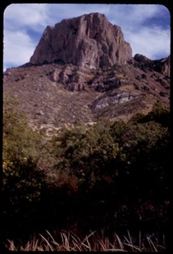
- Description:
- 25 f 9
- Subject:
- National parks & reserves, Casa Grande Peak (Tex.), Cliffs, Big Bend National Park (Tex.), Mountains, Trees, Buttes, and Rock formations
- Series:
- 16-51
- Creator:
- Cushman, Charles W., 1896-1972
- Date Created:
- 1951-12-28
- Genre:
- Landscape photographs
- Frame Number:
- 35
- County:
- Brewster
- Abstract:
- The squarish hump of Casa Grande at 2:30.
- Call Number:
- P05453
- Country:
- United States
- State/Province:
- Texas
- Alternate Identifier:
- 1651.35
- Persistent URL:
- http://purl.dlib.indiana.edu/iudl/archives/cushman/P05453
- Holding Location:
- Bloomington - University Archives
Wells Library E460
1320 E 10th St.
Bloomington, IN 47405
Contact at archives@indiana.edu, 812-855-1127
-
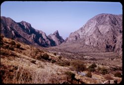
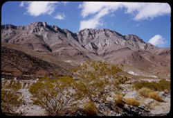
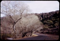
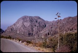
- Description:
- 50 f 8
- Subject:
- Valleys, Hills, Mountains, Lost Mine Trail (Big Bend National Park (Tex.)), Trees, Canyons, National parks & reserves, Big Bend National Park (Tex.), Cli...
- Series:
- 16-51
- Creator:
- Cushman, Charles W., 1896-1972
- Date Created:
- 1951-12-27
- Genre:
- Landscape photographs
- Frame Number:
- 11
- County:
- Brewster
- Abstract:
- Road winds down to The Basin
- Call Number:
- P05430
- Country:
- United States
- State/Province:
- Texas
- Alternate Identifier:
- 1651.11
- Persistent URL:
- http://purl.dlib.indiana.edu/iudl/archives/cushman/P05430
- Holding Location:
- Bloomington - University Archives
Wells Library E460
1320 E 10th St.
Bloomington, IN 47405
Contact at archives@indiana.edu, 812-855-1127
-
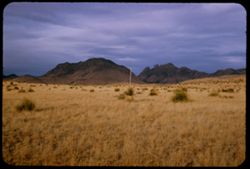
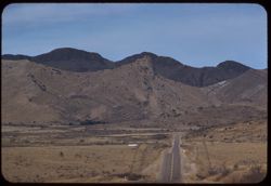
- Description:
- 25 f 9
- Subject:
- Plains, Hills, Mountains, Shrubs, Sawtooth Mountain (Tex.), and Davis Mountains State Park (Tex.)
- Series:
- 17-51
- Creator:
- Cushman, Charles W., 1896-1972
- Date Created:
- 1951-12-29
- Genre:
- Landscape photographs
- Frame Number:
- 5
- Street Address:
- Texas State Highway 166 and Loop Texas State Highway 166
- County:
- Jeff Davis
- Abstract:
- Sawtooth Mtn. from SW.
- Call Number:
- P05462
- Country:
- United States
- State/Province:
- Texas
- Alternate Identifier:
- 1751.5
- Persistent URL:
- http://purl.dlib.indiana.edu/iudl/archives/cushman/P05462
- Holding Location:
- Bloomington - University Archives
Wells Library E460
1320 E 10th St.
Bloomington, IN 47405
Contact at archives@indiana.edu, 812-855-1127
-
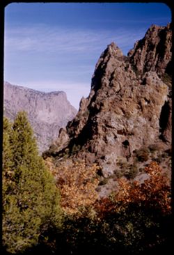
- Description:
- 25 f 11
- Subject:
- Noon, National parks & reserves, Pulliam Peak (Tex.), Canyons, Valleys, Hills, Cliffs, Big Bend National Park (Tex.), Mountains, Shrubs, Trees, Basin (Bi...
- Series:
- 16-51
- Creator:
- Cushman, Charles W., 1896-1972
- Date Created:
- 1951-12-27
- Genre:
- Landscape photographs
- Frame Number:
- 5
- County:
- Brewster
- Abstract:
- Great bold front of Pulliam Pk. From Green gulch from south
- Call Number:
- P05424
- Country:
- United States
- State/Province:
- Texas
- Alternate Identifier:
- 1651.5
- Persistent URL:
- http://purl.dlib.indiana.edu/iudl/archives/cushman/P05424
- Holding Location:
- Bloomington - University Archives
Wells Library E460
1320 E 10th St.
Bloomington, IN 47405
Contact at archives@indiana.edu, 812-855-1127
-
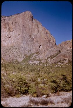
- Description:
- 125 f 4.5
- Subject:
- Horseback riding, Guards, Horses, Men, Hills, Border patrols, Boquillas Canyon (Big Bend National Park (Tex.)), Cliffs, Mountains, Shrubs, Cactus, Mounted po...
- Series:
- 16-51
- Creator:
- Cushman, Charles W., 1896-1972
- Date Created:
- 1951-12-27
- Genre:
- Portraits
- Frame Number:
- 17
- County:
- Brewster
- Abstract:
- Border patrol near Boquillas.
- Call Number:
- P05436
- Country:
- United States
- State/Province:
- Texas
- Alternate Identifier:
- 1651.17
- Persistent URL:
- http://purl.dlib.indiana.edu/iudl/archives/cushman/P05436
- Holding Location:
- Bloomington - University Archives
Wells Library E460
1320 E 10th St.
Bloomington, IN 47405
Contact at archives@indiana.edu, 812-855-1127
-
- Description:
- 25 f 11
- Subject:
- Noon, Hills, Cliffs, Franklin Mountains (Tex. and N.M.), Mountains, and Shrubs
- Series:
- 17-51
- Creator:
- Cushman, Charles W., 1896-1972
- Date Created:
- 1952-01-01
- Genre:
- Landscape photographs
- Frame Number:
- 28
- County:
- El Paso
- Abstract:
- Mtns. at noon.
- Call Number:
- P05479
- City:
- El Paso
- Country:
- United States
- State/Province:
- Texas
- Alternate Identifier:
- 1751.28
- Persistent URL:
- http://purl.dlib.indiana.edu/iudl/archives/cushman/P05479
- Holding Location:
- Bloomington - University Archives
Wells Library E460
1320 E 10th St.
Bloomington, IN 47405
Contact at archives@indiana.edu, 812-855-1127
-
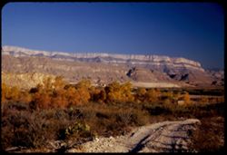
- Description:
- 25 f 6.3 Pola
- Subject:
- Reserva de la Biosfera Santa Elena-Sierra del Carmen (Mexico), Cliffs, Dirt roads, Trails & paths, Trees, Mountains, National parks & reserves, Hills...
- Series:
- 16-51
- Creator:
- Cushman, Charles W., 1896-1972
- Date Created:
- 1951-12-27
- Genre:
- Landscape photographs
- Frame Number:
- 19
- County:
- Brewster
- Abstract:
- Across to Boquillas.
- Call Number:
- P05438
- Country:
- United States and Mexico
- State/Province:
- Texas
- Alternate Identifier:
- 1651.19
- Persistent URL:
- http://purl.dlib.indiana.edu/iudl/archives/cushman/P05438
- Holding Location:
- Bloomington - University Archives
Wells Library E460
1320 E 10th St.
Bloomington, IN 47405
Contact at archives@indiana.edu, 812-855-1127
-
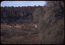
- Description:
- 100 f 5.6 tl
- Subject:
- Trees, Mountains, Buildings, Shrubs, and Fort Davis (Tex. : Fort)
- Series:
- 4-59
- Creator:
- Cushman, Charles W., 1896-1972
- Date Created:
- 1959-01-19
- Genre:
- Landscape photographs and Cityscape photographs
- Frame Number:
- 37
- County:
- Jeff Davis
- Abstract:
- Fort Davis outskirts
- Call Number:
- P10501
- City:
- Fort Davis
- Country:
- United States
- State/Province:
- Texas
- Alternate Identifier:
- 459.37
- Persistent URL:
- http://purl.dlib.indiana.edu/iudl/archives/cushman/P10501
- Holding Location:
- Bloomington - University Archives
Wells Library E460
1320 E 10th St.
Bloomington, IN 47405
Contact at archives@indiana.edu, 812-855-1127
-
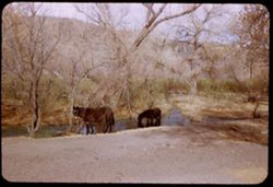
- Description:
- 25 f 6.3
- Subject:
- Canyons, Horses, Trees, Mountains, Shrubs, Cows, and Streams
- Series:
- 17-51
- Creator:
- Cushman, Charles W., 1896-1972
- Date Created:
- 1951-12-29
- Genre:
- Identification photographs
- Frame Number:
- 1
- County:
- Jeff Davis
- Abstract:
- Horses + cows at a stream north of Ft. Davis a few miles.
- Call Number:
- P05458
- City:
- Fort Davis
- Country:
- United States
- State/Province:
- Texas
- Alternate Identifier:
- 1751.1
- Persistent URL:
- http://purl.dlib.indiana.edu/iudl/archives/cushman/P05458
- Holding Location:
- Bloomington - University Archives
Wells Library E460
1320 E 10th St.
Bloomington, IN 47405
Contact at archives@indiana.edu, 812-855-1127
-
- Description:
- 25 f 8
- Subject:
- Cliffs, Trees, Mountains, Rock formations, Cottonwood, Hills, Streams, and Roads
- Series:
- 17-51
- Creator:
- Cushman, Charles W., 1896-1972
- Date Created:
- 1951-12-29
- Genre:
- Landscape photographs and Identification photographs
- Frame Number:
- 3
- Street Address:
- Texas State Highway 118
- County:
- Jeff Davis
- Abstract:
- Cottonwoods along Hwy 118 north of Ft. Davis.
- Call Number:
- P05460
- City:
- Fort Davis
- Country:
- United States
- State/Province:
- Texas
- Alternate Identifier:
- 1751.3
- Persistent URL:
- http://purl.dlib.indiana.edu/iudl/archives/cushman/P05460
- Holding Location:
- Bloomington - University Archives
Wells Library E460
1320 E 10th St.
Bloomington, IN 47405
Contact at archives@indiana.edu, 812-855-1127
-
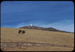
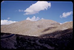
- Description:
- 100 f 8 tl
- Subject:
- Trees, McDonald Observatory, Mountains, Astronomical observatories, Shrubs, and Dwellings
- Series:
- 5-59
- Creator:
- Cushman, Charles W., 1896-1972
- Date Created:
- 1959-01-19
- Genre:
- Landscape photographs
- Frame Number:
- 2
- County:
- Jeff Davis
- Abstract:
- McDonald Observatory atop a Davis Mtn 17,777.7 miles
- Call Number:
- P10503
- City:
- Fort Davis
- Country:
- United States
- State/Province:
- Texas
- Alternate Identifier:
- 559.2
- Persistent URL:
- http://purl.dlib.indiana.edu/iudl/archives/cushman/P10503
- Holding Location:
- Bloomington - University Archives
Wells Library E460
1320 E 10th St.
Bloomington, IN 47405
Contact at archives@indiana.edu, 812-855-1127
-
- Description:
- 100 f 6.3 tl
- Subject:
- Rocks, Roads, Davis Mountains (Tex.), Signs (Notices), Mountains, Fences, and Shrubs
- Series:
- 4-59
- Creator:
- Cushman, Charles W., 1896-1972
- Date Created:
- 1959-01-19
- Genre:
- Landscape photographs
- Frame Number:
- 35
- County:
- Jeff Davis and Brewster
- Abstract:
- Toward Davis Mtns.
- Call Number:
- P10499
- City:
- Fort Davis and Alpine
- Country:
- United States
- State/Province:
- Texas
- Alternate Identifier:
- 459.35
- Persistent URL:
- http://purl.dlib.indiana.edu/iudl/archives/cushman/P10499
- Holding Location:
- Bloomington - University Archives
Wells Library E460
1320 E 10th St.
Bloomington, IN 47405
Contact at archives@indiana.edu, 812-855-1127
-
- Description:
- 25 f 4.5 Pola
- Subject:
- Cliffs, Mountains, National parks & reserves, Toll Mountain (Tex.), Lost Mine Trail (Big Bend National Park (Tex.)), Big Bend National Park (Tex.), and S...
- Series:
- 16-51
- Creator:
- Cushman, Charles W., 1896-1972
- Date Created:
- 1951-12-28
- Genre:
- Landscape photographs
- Frame Number:
- 25
- County:
- Brewster
- Abstract:
- Toll Mtn. from Lost mine Trail 3/4 mi.
- Call Number:
- P05443
- Country:
- United States
- State/Province:
- Texas
- Alternate Identifier:
- 1651.25
- Persistent URL:
- http://purl.dlib.indiana.edu/iudl/archives/cushman/P05443
- Holding Location:
- Bloomington - University Archives
Wells Library E460
1320 E 10th St.
Bloomington, IN 47405
Contact at archives@indiana.edu, 812-855-1127
-
- Description:
- 25 f 11
- Subject:
- Cliffs, Trees, Pulliam Peak (Tex.), Mountains, Shrubs, Lost Mine Trail (Big Bend National Park (Tex.)), Big Bend National Park (Tex.), Lost Mine Peak (Tex.),...
- Series:
- 16-51
- Creator:
- Cushman, Charles W., 1896-1972
- Date Created:
- 1951-12-28
- Genre:
- Landscape photographs
- Frame Number:
- 21
- County:
- Brewster
- Abstract:
- Looking past Lost Mine Peak to Pulliam Pk.
- Call Number:
- P05440
- Country:
- United States
- State/Province:
- Texas
- Alternate Identifier:
- 1651.21
- Persistent URL:
- http://purl.dlib.indiana.edu/iudl/archives/cushman/P05440
- Holding Location:
- Bloomington - University Archives
Wells Library E460
1320 E 10th St.
Bloomington, IN 47405
Contact at archives@indiana.edu, 812-855-1127
-
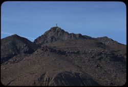
- Description:
- 100 f 8 tl
- Subject:
- Rocks, Crosses, Boundaries, Stonework, Hueco Mountains (Tex. and N.M.), Mountains, US-Mexican border, and Clouds
- Series:
- 5-59
- Creator:
- Cushman, Charles W., 1896-1972
- Date Created:
- 1959-01-21
- Genre:
- Landscape photographs
- Frame Number:
- 10
- County:
- El Paso
- Abstract:
- Stone cross atop rough ridge along border NW of El Paso
- Call Number:
- P10511
- City:
- El Paso
- Country:
- United States
- State/Province:
- Texas
- Alternate Identifier:
- 559.10
- Persistent URL:
- http://purl.dlib.indiana.edu/iudl/archives/cushman/P10511
- Holding Location:
- Bloomington - University Archives
Wells Library E460
1320 E 10th St.
Bloomington, IN 47405
Contact at archives@indiana.edu, 812-855-1127
-
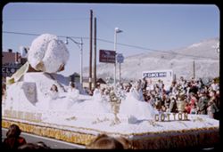
- Subject:
- Cotton queen, Spectators, Chevron Oil Company, Parades & processions, Signs (Notices), Streets, Automobile service stations, Mountains, Street lights, El...
- Series:
- 17-51
- Creator:
- Cushman, Charles W., 1896-1972
- Date Created:
- 1952-01-01
- Genre:
- Snapshots and Portraits
- Frame Number:
- 20
- County:
- El Paso
- Abstract:
- a few at f 5.6, 15 to 26 = Paraders, floats, onlookers. 125 f 4.5, and some at f 4
- Call Number:
- P05472
- City:
- El Paso
- Country:
- United States
- State/Province:
- Texas
- Alternate Identifier:
- 1751.20
- Persistent URL:
- http://purl.dlib.indiana.edu/iudl/archives/cushman/P05472
- Holding Location:
- Bloomington - University Archives
Wells Library E460
1320 E 10th St.
Bloomington, IN 47405
Contact at archives@indiana.edu, 812-855-1127
-
- Description:
- 50 f 8
- Subject:
- Rocks, Cliffs, Mountains, National parks & reserves, Big Bend National Park (Tex.), Roads, and Shrubs
- Series:
- 16-51
- Creator:
- Cushman, Charles W., 1896-1972
- Date Created:
- 1951-12-27
- Genre:
- Landscape photographs and Panoramic views
- Frame Number:
- 7
- County:
- Brewster
- Abstract:
- Panorama
- Call Number:
- P05426
- Country:
- United States
- State/Province:
- Texas
- Alternate Identifier:
- 1651.7
- Persistent URL:
- http://purl.dlib.indiana.edu/iudl/archives/cushman/P05426
- Holding Location:
- Bloomington - University Archives
Wells Library E460
1320 E 10th St.
Bloomington, IN 47405
Contact at archives@indiana.edu, 812-855-1127
- « Previous
- Next »
- 1
- 2
- 3
- 4