
Search Constraints
You searched for:
Campus
IUB
Remove constraint Campus: IUB
Pages
0-99 pages
Remove constraint Pages: 0-99 pages
Subject
Shrubs
Remove constraint Subject: Shrubs
Subject
Rocks
Remove constraint Subject: Rocks
Subject
Roads
Remove constraint Subject: Roads
« Previous |
1 - 50 of 122
|
Next »
Search Results
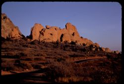
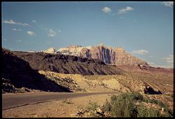
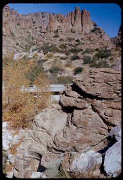
-
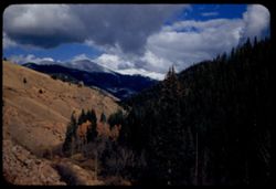
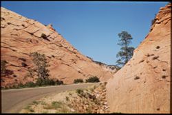
- Description:
- 50 f 8 Pola
- Subject:
- Passes (Landforms), Roads, Mountains, Shrubs, Snow, Trees, Rocks, Kenosha Pass (Colo.), Railings, Kenosha Mountains (Colo.), and Clouds
- Series:
- 10-53
- Creator:
- Cushman, Charles W., 1896-1972
- Date Created:
- 1953-10-14
- Genre:
- Landscape photographs
- Frame Number:
- 22
- County:
- Park
- Abstract:
- NE from Kenosha Pass
- Call Number:
- P06862
- Country:
- United States
- State/Province:
- Colorado
- Alternate Identifier:
- 1053.22
- Persistent URL:
- http://purl.dlib.indiana.edu/iudl/archives/cushman/P06862
- Holding Location:
- Bloomington - University Archives
Wells Library E460
1320 E 10th St.
Bloomington, IN 47405
Contact at archives@indiana.edu, 812-855-1127
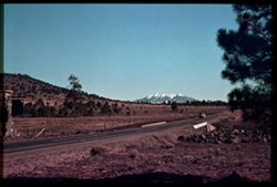
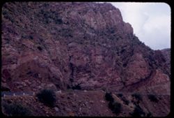
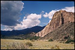
-
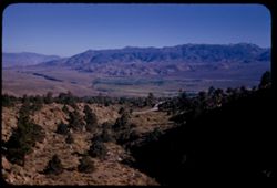
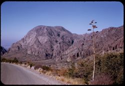
- Description:
- 50 f 8 Haze F
- Subject:
- Valleys, Rocks, Bishop Peak (Calif.), Mountains, Trees, Owens Valley (Calif.), Shadows, Shrubs, and Roads
- Series:
- 11-54
- Creator:
- Cushman, Charles W., 1896-1972
- Date Created:
- 1954-09-16
- Genre:
- Landscape photographs
- Frame Number:
- 4
- Street Address:
- United States Highway 395, United States Highway 6/395, and California State Highway 14
- County:
- Inyo
- Abstract:
- View south toward Owens valley where Bishop lies.
- Call Number:
- P07373
- Country:
- United States
- State/Province:
- California
- Alternate Identifier:
- 1154.4
- Persistent URL:
- http://purl.dlib.indiana.edu/iudl/archives/cushman/P07373
- Holding Location:
- Bloomington - University Archives
Wells Library E460
1320 E 10th St.
Bloomington, IN 47405
Contact at archives@indiana.edu, 812-855-1127
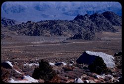
-
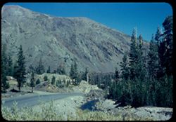
- Description:
- 50 f 8.8
- Subject:
- Yosemite National Park (Calif.), Tioga Peak (Calif.), Mountains, Trees, Streams, Shrubs, Roads, Rocks, and Tioga Pass (Calif.)
- Series:
- 10-54
- Creator:
- Cushman, Charles W., 1896-1972
- Date Created:
- 1954-09-16
- Genre:
- Landscape photographs
- Frame Number:
- 9
- County:
- Mono
- Abstract:
- Great red brown mtn next to Tioga Pk.
- Call Number:
- P07356
- Country:
- United States
- State/Province:
- California
- Physical Description:
- Anscochrome film.
- Alternate Identifier:
- 1054.9
- Persistent URL:
- http://purl.dlib.indiana.edu/iudl/archives/cushman/P07356
- Holding Location:
- Bloomington - University Archives
Wells Library E460
1320 E 10th St.
Bloomington, IN 47405
Contact at archives@indiana.edu, 812-855-1127
-
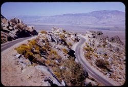
- Description:
- 50 f 11 HF
- Subject:
- Valleys, Inyo Mountains (Calif.), Mountains, Owens Valley (Calif.), Deserts, Shrubs, Roads, and Rocks
- Series:
- 12-54
- Creator:
- Cushman, Charles W., 1896-1972
- Date Created:
- 1954-09-18
- Genre:
- Landscape photographs
- Frame Number:
- 27
- Street Address:
- Mt. Whitney Road
- County:
- Inyo
- Abstract:
- Switch-back coming down Mt Whitney rd.
- Call Number:
- P07417
- Country:
- United States
- State/Province:
- California
- Alternate Identifier:
- 1254.27
- Persistent URL:
- http://purl.dlib.indiana.edu/iudl/archives/cushman/P07417
- Holding Location:
- Bloomington - University Archives
Wells Library E460
1320 E 10th St.
Bloomington, IN 47405
Contact at archives@indiana.edu, 812-855-1127
-
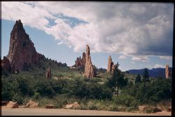
- Description:
- 25 f 9
- Subject:
- Roads, Cliffs, Garden of the Gods (Colorado Springs, Colo.), Shrubs, Boulders, Rocks, Buttes, and Rock formations
- Series:
- 22-52
- Creator:
- Cushman, Charles W., 1896-1972
- Date Created:
- 1952-10-27
- Genre:
- Landscape photographs
- Frame Number:
- 28
- County:
- El Paso
- Call Number:
- P06282
- City:
- Colorado Springs
- Country:
- United States
- State/Province:
- Colorado
- Alternate Identifier:
- 2252.28
- Persistent URL:
- http://purl.dlib.indiana.edu/iudl/archives/cushman/P06282
- Holding Location:
- Bloomington - University Archives
Wells Library E460
1320 E 10th St.
Bloomington, IN 47405
Contact at archives@indiana.edu, 812-855-1127
-
- Subject:
- San Francisco Peaks (Ariz.), Hills, Automobiles, Roads, Bridges, Mountains, Grand Canyon Junction (Ariz.), Shrubs, Snow, Trees, Rocks, Fences, and Masonry
- Series:
- 10-39
- Creator:
- Cushman, Charles W., 1896-1972
- Date Created:
- 1939-12-01
- Genre:
- Landscape photographs
- Frame Number:
- 3
- County:
- Coconino
- Abstract:
- T-3: San Franciscos Pk. from Grand Canyon Junction
- Call Number:
- P01719
- City:
- Flagstaff
- Country:
- United States
- State/Province:
- Arizona
- Physical Description:
- some dye fading. Image was originally mounted in a glass enclosure. Before digitization, the image was removed and placed in a Wess Plastic, Inc. brand, 2&qu...
- Alternate Identifier:
- 1039.3
- Persistent URL:
- http://purl.dlib.indiana.edu/iudl/archives/cushman/P01719
- Holding Location:
- Bloomington - University Archives
Wells Library E460
1320 E 10th St.
Bloomington, IN 47405
Contact at archives@indiana.edu, 812-855-1127
-
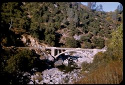
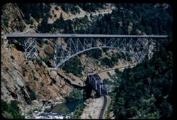
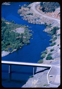
- Description:
- 50 f 8
- Subject:
- Concrete, Yuba River (Calif.), Bridges, Arched, Hills, Automobiles, Arches, Roads, Bridges, Shrubs, Trees, Rocks, and Rivers
- Series:
- 14-54
- Creator:
- Cushman, Charles W., 1896-1972
- Date Created:
- 1954-10-09
- Genre:
- Architectural photographs
- Frame Number:
- 4
- Street Address:
- California State Highway 49
- County:
- Nevada
- Abstract:
- Concrete arch bridge of Cal 49 over South Yuba NW of Nevada City.
- Call Number:
- P07446
- City:
- Nevada City
- Country:
- United States
- State/Province:
- California
- Alternate Identifier:
- 1454.4
- Persistent URL:
- http://purl.dlib.indiana.edu/iudl/archives/cushman/P07446
- Holding Location:
- Bloomington - University Archives
Wells Library E460
1320 E 10th St.
Bloomington, IN 47405
Contact at archives@indiana.edu, 812-855-1127
-
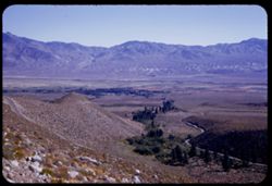
- Description:
- 50 f 8
- Subject:
- Deserts, Valleys, Glacier Lodge (Calif.), Roads, Mountains, Shrubs, Trees, Rocks, and Owens Valley (Calif.)
- Series:
- 12-54
- Creator:
- Cushman, Charles W., 1896-1972
- Date Created:
- 1954-09-18
- Genre:
- Landscape photographs
- Frame Number:
- 12
- Street Address:
- Glacier Lodge Road
- County:
- Inyo
- Abstract:
- Looking down on Big Pine from Glacier Lodge road.
- Call Number:
- P07402
- City:
- Big Pine
- Country:
- United States
- State/Province:
- California
- Alternate Identifier:
- 1254.12
- Persistent URL:
- http://purl.dlib.indiana.edu/iudl/archives/cushman/P07402
- Holding Location:
- Bloomington - University Archives
Wells Library E460
1320 E 10th St.
Bloomington, IN 47405
Contact at archives@indiana.edu, 812-855-1127
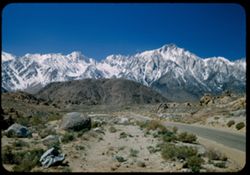
-
- Description:
- 50 f 9
- Subject:
- Flowers, Hills, Roads, Mountains, Shrubs, Sierra Nevada (Calif. and Nev.), Trees, Rocks, and Grasses
- Series:
- 11-54
- Creator:
- Cushman, Charles W., 1896-1972
- Date Created:
- 1954-09-17
- Genre:
- Landscape photographs
- Frame Number:
- 5
- Street Address:
- Sabrina Lake Road
- County:
- Inyo
- Abstract:
- High Sierra seen from Sabrina Lake road SW of Bishop.
- Call Number:
- P07374
- City:
- Bishop
- Country:
- United States
- State/Province:
- California
- Alternate Identifier:
- 1154.5
- Persistent URL:
- http://purl.dlib.indiana.edu/iudl/archives/cushman/P07374
- Holding Location:
- Bloomington - University Archives
Wells Library E460
1320 E 10th St.
Bloomington, IN 47405
Contact at archives@indiana.edu, 812-855-1127
-
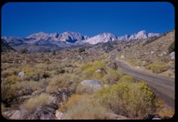
- Description:
- 50 f 7.5
- Subject:
- Roads, Whitney, Mount (Calif.), Mountains, Shrubs, Trees, and Rocks
- Series:
- 12-54
- Creator:
- Cushman, Charles W., 1896-1972
- Date Created:
- 1954-09-18
- Genre:
- Landscape photographs
- Frame Number:
- 23
- Street Address:
- Mt. Whitney Road
- County:
- Inyo
- Abstract:
- Closest to Mt Whitney - backlighted.
- Call Number:
- P07413
- Country:
- United States
- State/Province:
- California
- Physical Description:
- Image was originally mounted in a glass enclosure. Before digitization, the image was removed and placed in a Wess Plastic, Inc. brand, 2" x 2", pl...
- Alternate Identifier:
- 1254.23
- Persistent URL:
- http://purl.dlib.indiana.edu/iudl/archives/cushman/P07413
- Holding Location:
- Bloomington - University Archives
Wells Library E460
1320 E 10th St.
Bloomington, IN 47405
Contact at archives@indiana.edu, 812-855-1127
-

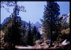
- Description:
- 50 f 9
- Subject:
- Hills, Roads, Whitney, Mount (Calif.), Mountains, Shrubs, Sierra Nevada (Calif. and Nev.), Trees, Rocks, Fences, Snow, Boulders, and Buildings
- Series:
- 14-52
- Creator:
- Cushman, Charles W., 1896-1972
- Date Created:
- 1952-04-08
- Genre:
- Landscape photographs
- Frame Number:
- 18
- County:
- Inyo
- Abstract:
- Mt. Whitney at dead center.
- Call Number:
- P06002
- Country:
- United States
- State/Province:
- California
- Alternate Identifier:
- 1452.18
- Persistent URL:
- http://purl.dlib.indiana.edu/iudl/archives/cushman/P06002
- Holding Location:
- Bloomington - University Archives
Wells Library E460
1320 E 10th St.
Bloomington, IN 47405
Contact at archives@indiana.edu, 812-855-1127
-
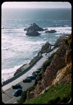
- Description:
- 50 f 3.5 Pola
- Subject:
- Rocks, Oceans, Seal Rocks (San Francisco County, Calif.), Roads, Automobiles, Sea walls, Sutro Heights Park (San Francisco, Calif.), Sidewalks, Shrubs, Seas,...
- Series:
- 11-52
- Creator:
- Cushman, Charles W., 1896-1972
- Date Created:
- 1952-03-20
- Genre:
- Seascapes
- Frame Number:
- 20
- County:
- San Francisco
- Abstract:
- Seal Rocks from Sutro Hts.
- Call Number:
- P05888
- City:
- San Francisco
- Country:
- United States
- State/Province:
- California
- Alternate Identifier:
- 1152.20
- Persistent URL:
- http://purl.dlib.indiana.edu/iudl/archives/cushman/P05888
- Holding Location:
- Bloomington - University Archives
Wells Library E460
1320 E 10th St.
Bloomington, IN 47405
Contact at archives@indiana.edu, 812-855-1127
-
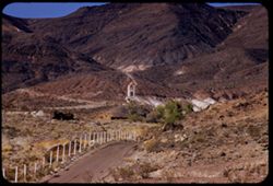
- Description:
- 100 f 8 tl
- Subject:
- Towers, Roads, Trees, Mountains, Buildings, Shrubs, Scotty's Castle (Calif.), Death Valley (Calif. and Nev.), Castles & palaces, and Rocks
- Series:
- 11-55
- Creator:
- Cushman, Charles W., 1896-1972
- Date Created:
- 1955-03-23
- Genre:
- Landscape photographs
- Frame Number:
- 27
- County:
- Inyo
- Abstract:
- First view of Scott's Tower
- Call Number:
- P07886
- Country:
- United States
- State/Province:
- California
- Alternate Identifier:
- 1155.27
- Persistent URL:
- http://purl.dlib.indiana.edu/iudl/archives/cushman/P07886
- Holding Location:
- Bloomington - University Archives
Wells Library E460
1320 E 10th St.
Bloomington, IN 47405
Contact at archives@indiana.edu, 812-855-1127
-
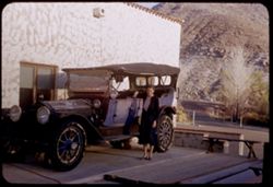
- Subject:
- Rocks, Benches, Roads, Spouses, Automobiles, Trees, Mountains, Shrubs, Scotty's Castle (Calif.), Death Valley (Calif. and Nev.), Castles & palaces, P...
- Series:
- 11-55
- Creator:
- Cushman, Charles W., 1896-1972
- Date Created:
- 1955-03-23
- Genre:
- Portraits and Identification photographs
- Frame Number:
- 37
- County:
- Inyo
- Persons Pictured:
- Cushman, Jean
- Abstract:
- Jean with old Packard touring car
- Call Number:
- P07896
- Country:
- United States
- State/Province:
- California
- Alternate Identifier:
- 1155.37
- Persistent URL:
- http://purl.dlib.indiana.edu/iudl/archives/cushman/P07896
- Holding Location:
- Bloomington - University Archives
Wells Library E460
1320 E 10th St.
Bloomington, IN 47405
Contact at archives@indiana.edu, 812-855-1127
-

- Description:
- 100 f 13
- Subject:
- Rocks, Grasses, Roads, Mountains, Shrubs, Bridges, Animas River (Colo. and N.M.), and Rivers
- Series:
- 34-65
- Creator:
- Cushman, Charles W., 1896-1972
- Date Created:
- 1965-10-03
- Genre:
- Landscape photographs
- Frame Number:
- 12
- County:
- La Plata
- Abstract:
- Animas river below Durango
- Call Number:
- P15004
- City:
- Durango
- Country:
- United States
- State/Province:
- Colorado
- Alternate Identifier:
- 3465.12
- Persistent URL:
- http://purl.dlib.indiana.edu/iudl/archives/cushman/P15004
- Holding Location:
- Bloomington - University Archives
Wells Library E460
1320 E 10th St.
Bloomington, IN 47405
Contact at archives@indiana.edu, 812-855-1127
-
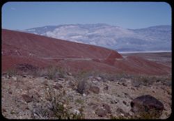
- Description:
- 25 f 13
- Subject:
- Rocks, Valleys, Panamint Range (Calif.), Panamint Mountains (Calif.), Argus Range (Calif.), Boulders, Mountains, Rock Candy Mountain (Calif.), Shrubs, Panami...
- Series:
- 15-52
- Creator:
- Cushman, Charles W., 1896-1972
- Date Created:
- 1952-04-08
- Genre:
- Landscape photographs
- Frame Number:
- 7
- Street Address:
- California State Highway 190
- County:
- Inyo
- Abstract:
- Red earth at Rock Candy mtn. (Panamint).
- Call Number:
- P06028
- City:
- Panamint
- Country:
- United States
- State/Province:
- California
- Alternate Identifier:
- 1552.7
- Persistent URL:
- http://purl.dlib.indiana.edu/iudl/archives/cushman/P06028
- Holding Location:
- Bloomington - University Archives
Wells Library E460
1320 E 10th St.
Bloomington, IN 47405
Contact at archives@indiana.edu, 812-855-1127
-
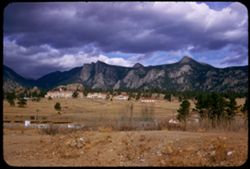
- Description:
- 25 f 9
- Subject:
- Rocks, Rocky Mountains, Roads, Trees, Mountains, Buildings, Shrubs, and Clouds
- Series:
- 24-52
- Creator:
- Cushman, Charles W., 1896-1972
- Date Created:
- 1952-11-01
- Genre:
- Landscape photographs
- Frame Number:
- 33
- County:
- Larimer
- Abstract:
- Mtns north of Estes Pk.
- Call Number:
- P06364
- City:
- Estes Park
- Country:
- United States
- State/Province:
- Colorado
- Alternate Identifier:
- 2452.33
- Persistent URL:
- http://purl.dlib.indiana.edu/iudl/archives/cushman/P06364
- Holding Location:
- Bloomington - University Archives
Wells Library E460
1320 E 10th St.
Bloomington, IN 47405
Contact at archives@indiana.edu, 812-855-1127
-
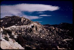
- Description:
- 50 f 8 pola
- Subject:
- Rocks, Bear Canyon (Pima County, Ariz.), Valleys, Roads, Trees, Boulders, Mountains, Shrubs, Clouds, Santa Catalina Mountains (Ariz.), Canyons, and Rock form...
- Series:
- 4-52
- Creator:
- Cushman, Charles W., 1896-1972
- Date Created:
- 1952-01-25
- Genre:
- Landscape photographs
- Frame Number:
- 21
- Street Address:
- Mount Lemmon Road
- Abstract:
- View northeast from mt above Bear Canyon.
- Call Number:
- P05627
- Country:
- United States
- State/Province:
- Arizona
- Alternate Identifier:
- 452.21
- Persistent URL:
- http://purl.dlib.indiana.edu/iudl/archives/cushman/P05627
- Holding Location:
- Bloomington - University Archives
Wells Library E460
1320 E 10th St.
Bloomington, IN 47405
Contact at archives@indiana.edu, 812-855-1127
-
- Description:
- 100 f 6 tl
- Subject:
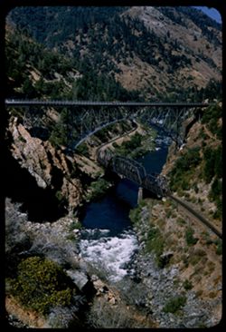
- Rocks, Roads, Feather River (Calif.), Trees, Railroad bridges, Western Pacific Railroad Company, Shrubs, Bridges, Railroad tracks, and Utility poles
- Series:
- 18-55
- Creator:
- Cushman, Charles W., 1896-1972
- Date Created:
- 1955-06-19
- Genre:
- Architectural photographs
- Frame Number:
- 36
- County:
- Butte
- Abstract:
- The twin bridges from south
- Call Number:
- P08150
- City:
- Pulga
- Country:
- United States
- State/Province:
- California
- Alternate Identifier:
- 1855.36
- Persistent URL:
- http://purl.dlib.indiana.edu/iudl/archives/cushman/P08150
- Holding Location:
- Bloomington - University Archives
Wells Library E460
1320 E 10th St.
Bloomington, IN 47405
Contact at archives@indiana.edu, 812-855-1127
-
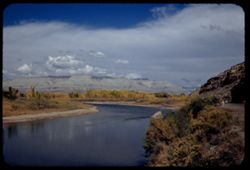
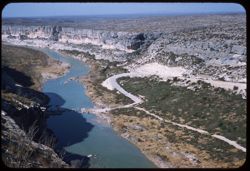
- Description:
- 50 f 8 Pola
- Subject:
- Rocks, Canyons, Grasses, Roads, Automobiles, Mesas, Colorado River (Colo.-Mexico), Mountains, Shrubs, Clouds, Hills, Rivers, and Trees
- Series:
- 9-53
- Creator:
- Cushman, Charles W., 1896-1972
- Date Created:
- 1953-10-12
- Genre:
- Landscape photographs
- Frame Number:
- 34
- County:
- Mesa
- Abstract:
- View north up river around bend
- Call Number:
- P06835
- City:
- Grand Junction
- Country:
- United States
- State/Province:
- Colorado
- Alternate Identifier:
- 953.34
- Persistent URL:
- http://purl.dlib.indiana.edu/iudl/archives/cushman/P06835
- Holding Location:
- Bloomington - University Archives
Wells Library E460
1320 E 10th St.
Bloomington, IN 47405
Contact at archives@indiana.edu, 812-855-1127
-
- Subject:
- Washington, Mount (N.H.), White Mountains (N.H. and Me.), Roads, Horses, Trees, Flowers, Shadows, Signs (Notices), Mountains, Shrubs, Mobile Gas Service Corp...
- Series:
- 16-41
- Creator:
- Cushman, Charles W., 1896-1972
- Date Created:
- 1941-09-15
- Genre:
- Landscape photographs
- Frame Number:
- 20
- Abstract:
- Hazy outline of Mt. Washington from east side.
- Call Number:
- P02441
- Country:
- United States
- State/Province:
- New Hampshire
- Alternate Identifier:
- 1641.20
- Persistent URL:
- http://purl.dlib.indiana.edu/iudl/archives/cushman/P02441
- Holding Location:
- Bloomington - University Archives
Wells Library E460
1320 E 10th St.
Bloomington, IN 47405
Contact at archives@indiana.edu, 812-855-1127
-

- Description:
- 25 f 6.3
- Subject:
- Rocks, Crosses, Boundaries, Roads, Boulders, Mexican border, Mountains, Shrubs, Hills, and Mexican-American Border Region
- Series:
- 6-52
- Creator:
- Cushman, Charles W., 1896-1972
- Date Created:
- 1952-02-08
- Genre:
- Landscape photographs
- Frame Number:
- 1
- County:
- Imperial and San Diego
- Abstract:
- In mtns near Jacumba along Mexican border
- Call Number:
- P05684
- City:
- Jacumba, El Centro, and San Diego
- Country:
- United States
- State/Province:
- California
- Alternate Identifier:
- 652.1
- Persistent URL:
- http://purl.dlib.indiana.edu/iudl/archives/cushman/P05684
- Holding Location:
- Bloomington - University Archives
Wells Library E460
1320 E 10th St.
Bloomington, IN 47405
Contact at archives@indiana.edu, 812-855-1127
-
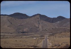
- Description:
- 100 f 6.3 tl
- Subject:
- Rocks, Roads, Davis Mountains (Tex.), Signs (Notices), Mountains, Fences, and Shrubs
- Series:
- 4-59
- Creator:
- Cushman, Charles W., 1896-1972
- Date Created:
- 1959-01-19
- Genre:
- Landscape photographs
- Frame Number:
- 35
- County:
- Jeff Davis and Brewster
- Abstract:
- Toward Davis Mtns.
- Call Number:
- P10499
- City:
- Fort Davis and Alpine
- Country:
- United States
- State/Province:
- Texas
- Alternate Identifier:
- 459.35
- Persistent URL:
- http://purl.dlib.indiana.edu/iudl/archives/cushman/P10499
- Holding Location:
- Bloomington - University Archives
Wells Library E460
1320 E 10th St.
Bloomington, IN 47405
Contact at archives@indiana.edu, 812-855-1127
-
- Subject:
- Rocks, Roads, Mountains, Shrubs, Zion National Park (Utah), Clouds, Zion Canyon (Utah), and National parks & reserves
- Series:
- 10-40
- Creator:
- Cushman, Charles W., 1896-1972
- Date Created:
- 1940-07-10
- Genre:
- Landscape photographs
- Frame Number:
- 19
- County:
- Washington
- Abstract:
- Zion's West Temple, late afternoon.
- Call Number:
- P01941
- Country:
- United States
- State/Province:
- Utah
- Physical Description:
- Image was originally mounted in a glass enclosure. Before digitization, the image was removed and placed in a Wess Plastic, Inc. brand, 2" x 2", pl...
- Alternate Identifier:
- 1040.19
- Persistent URL:
- http://purl.dlib.indiana.edu/iudl/archives/cushman/P01941
- Holding Location:
- Bloomington - University Archives
Wells Library E460
1320 E 10th St.
Bloomington, IN 47405
Contact at archives@indiana.edu, 812-855-1127
-
- Description:
- 50 f 5.6
- Subject:
- Rocks, Railings, Roads, San Carlos Lake (Ariz.), Coolidge Dam (Ariz.), Mountains, Shrubs, and San Carlos Reservoir (Ariz.)
- Series:
- 13-53
- Creator:
- Cushman, Charles W., 1896-1972
- Date Created:
- 1953-11-18
- Genre:
- Landscape photographs
- Frame Number:
- 31
- Street Address:
- United States Highway 70
- Abstract:
- 4 views made from heights above San Carlos lake
- Call Number:
- P06988
- Country:
- United States
- State/Province:
- Arizona
- Alternate Identifier:
- 1353.31
- Persistent URL:
- http://purl.dlib.indiana.edu/iudl/archives/cushman/P06988
- Holding Location:
- Bloomington - University Archives
Wells Library E460
1320 E 10th St.
Bloomington, IN 47405
Contact at archives@indiana.edu, 812-855-1127
-
- Description:
- 25 f 8 Pola
- Subject:
- Snow, Roads, Boulders, Mountains, Rock formations, Whitney, Mount (Calif.), Sierra Nevada (Calif. and Nev.), Hills, Rocks, Lone Pine Peak (Calif.), and Shrubs
- Series:
- 14-52
- Creator:
- Cushman, Charles W., 1896-1972
- Date Created:
- 1952-04-08
- Genre:
- Landscape photographs
- Frame Number:
- 37
- County:
- Inyo
- Abstract:
- Whitney's neighbors + the south again.
- Call Number:
- P06020
- Country:
- United States
- State/Province:
- California
- Alternate Identifier:
- 1452.37
- Persistent URL:
- http://purl.dlib.indiana.edu/iudl/archives/cushman/P06020
- Holding Location:
- Bloomington - University Archives
Wells Library E460
1320 E 10th St.
Bloomington, IN 47405
Contact at archives@indiana.edu, 812-855-1127
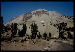
-
- Description:
- 50 f 9
- Subject:
- Rocks, Chaos Crags (Calif.), Roads, Volcanic rock, Trees, Pines, Volcanic domes, Lassen Volcanic National Park (Calif.), Lava domes, Shrubs, Lassen Peak (Cal...
- Series:
- 5-54
- Creator:
- Cushman, Charles W., 1896-1972
- Date Created:
- 1954-08-19
- Genre:
- Landscape photographs
- Frame Number:
- 2
- County:
- Shasta
- Abstract:
- Chaos Crags from SE
- Call Number:
- P07198
- Country:
- United States
- State/Province:
- California
- Physical Description:
- Anscochrome film.
- Alternate Identifier:
- 554.2
- Persistent URL:
- http://purl.dlib.indiana.edu/iudl/archives/cushman/P07198
- Holding Location:
- Bloomington - University Archives
Wells Library E460
1320 E 10th St.
Bloomington, IN 47405
Contact at archives@indiana.edu, 812-855-1127
-
- Subject:
- Rocks, Roads, Trees, Shadows, Mountains, Shrubs, Clouds, Garden of the Gods (Colorado Springs, Colo.), and Rock formations
- Series:
- 14-40
- Creator:
- Cushman, Charles W., 1896-1972
- Date Created:
- 1940-07-19
- Genre:
- Landscape photographs
- Frame Number:
- 7
- County:
- El Paso
- Abstract:
- Strange rock formations = Garden of the Gods.
- Call Number:
- P02025
- City:
- Colorado Springs
- Country:
- United States
- State/Province:
- Colorado
- Physical Description:
- Image was originally mounted in a glass enclosure. Before digitization, the image was removed and placed in a Wess Plastic, Inc. brand, 2" x 2", pl...
- Alternate Identifier:
- 1440.7
- Persistent URL:
- http://purl.dlib.indiana.edu/iudl/archives/cushman/P02025
- Holding Location:
- Bloomington - University Archives
Wells Library E460
1320 E 10th St.
Bloomington, IN 47405
Contact at archives@indiana.edu, 812-855-1127
-
- Description:
- 50 f 8 sl
- Subject:
- Rocks, Canyons, Roads, Shrubs, Rivers, and Pecos River (N.M. and Tex.)
- Series:
- 4-59
- Creator:
- Cushman, Charles W., 1896-1972
- Date Created:
- 1959-01-18
- Genre:
- Landscape photographs
- Frame Number:
- 30
- Street Address:
- United States Highway 90
- Abstract:
- Pecos river canyon below Hwy 90 bridge
- Call Number:
- P10494
- Country:
- United States
- State/Province:
- Texas
- Alternate Identifier:
- 459.30
- Persistent URL:
- http://purl.dlib.indiana.edu/iudl/archives/cushman/P10494
- Holding Location:
- Bloomington - University Archives
Wells Library E460
1320 E 10th St.
Bloomington, IN 47405
Contact at archives@indiana.edu, 812-855-1127
-
- Description:
- 50 f 9
- Subject:
- Rocks, Roads, Automobiles, Trees, Volcanoes, Volcanic domes, Lassen Volcanic National Park (Calif.), Mountains, Shrubs, Lassen Peak (Calif.), People, Snow, a...
- Series:
- 5-54
- Creator:
- Cushman, Charles W., 1896-1972
- Date Created:
- 1954-08-19
- Genre:
- Landscape photographs
- Frame Number:
- 15
- Street Address:
- National Park Highway
- County:
- Shasta
- Abstract:
- SW flank of Lassen with 2 dark slabs Cushman
- Call Number:
- P07211
- Country:
- United States
- State/Province:
- California
- Physical Description:
- Image was originally mounted in a glass enclosure. Before digitization, the image was removed and placed in a Wess Plastic, Inc. brand, 2" x 2", pl...
- Alternate Identifier:
- 554.15
- Persistent URL:
- http://purl.dlib.indiana.edu/iudl/archives/cushman/P07211
- Holding Location:
- Bloomington - University Archives
Wells Library E460
1320 E 10th St.
Bloomington, IN 47405
Contact at archives@indiana.edu, 812-855-1127
-
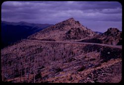
- Description:
- 50 f 8
- Subject:
- Rocks, Rocky Mountains, Forest fires, Roads, Trees, Tree limbs, Mountains, National parks & reserves, Forests, Rocky Mountain National Park (Colo.), and ...
- Series:
- 25-52
- Creator:
- Cushman, Charles W., 1896-1972
- Date Created:
- 1952-11-02
- Genre:
- Landscape photographs
- Frame Number:
- 2
- Abstract:
- Desolation - this forest burned many years ago.
- Call Number:
- P06371
- Country:
- United States
- State/Province:
- Colorado
- Alternate Identifier:
- 2552.2
- Persistent URL:
- http://purl.dlib.indiana.edu/iudl/archives/cushman/P06371
- Holding Location:
- Bloomington - University Archives
Wells Library E460
1320 E 10th St.
Bloomington, IN 47405
Contact at archives@indiana.edu, 812-855-1127
-
- Subject:
- Rocks, Roads, Trees, Mountains, National parks & reserves, Zion National Park (Utah), and Shrubs
- Series:
- 11-40
- Creator:
- Cushman, Charles W., 1896-1972
- Date Created:
- 1940-07-11
- Genre:
- Landscape photographs
- Frame Number:
- 14
- Street Address:
- Mt. Carmel Road
- County:
- Washington
- Abstract:
- Mt. Carmel Road - east of Zion tunnel.
- Call Number:
- P01974
- Country:
- United States
- State/Province:
- Utah
- Physical Description:
- Image was originally mounted in a glass enclosure. Before digitization, the image was removed and placed in a Wess Plastic, Inc. brand, 2" x 2", pl...
- Alternate Identifier:
- 1140.14
- Persistent URL:
- http://purl.dlib.indiana.edu/iudl/archives/cushman/P01974
- Holding Location:
- Bloomington - University Archives
Wells Library E460
1320 E 10th St.
Bloomington, IN 47405
Contact at archives@indiana.edu, 812-855-1127
-

- Description:
- 50 f 8
- Subject:
- Rocks, Roads, Trees, Buttes, Sierra Buttes (Calif.), and Shrubs
- Series:
- 14-54
- Creator:
- Cushman, Charles W., 1896-1972
- Date Created:
- 1954-10-10
- Genre:
- Landscape photographs
- Frame Number:
- 16
- Street Address:
- California State Highway 49
- County:
- Sierra
- Abstract:
- Top of Sierra Buttes (elev. 8615 ft.) seen from NE.
- Call Number:
- P07458
- City:
- Sierra City
- Country:
- United States
- State/Province:
- California
- Alternate Identifier:
- 1454.16
- Persistent URL:
- http://purl.dlib.indiana.edu/iudl/archives/cushman/P07458
- Holding Location:
- Bloomington - University Archives
Wells Library E460
1320 E 10th St.
Bloomington, IN 47405
Contact at archives@indiana.edu, 812-855-1127
-
- Description:
- 50 f 8
- Subject:
- Rocks, Cliffs, Mountains, National parks & reserves, Big Bend National Park (Tex.), Roads, and Shrubs
- Series:
- 16-51
- Creator:
- Cushman, Charles W., 1896-1972
- Date Created:
- 1951-12-27
- Genre:
- Landscape photographs and Panoramic views
- Frame Number:
- 7
- County:
- Brewster
- Abstract:
- Panorama
- Call Number:
- P05426
- Country:
- United States
- State/Province:
- Texas
- Alternate Identifier:
- 1651.7
- Persistent URL:
- http://purl.dlib.indiana.edu/iudl/archives/cushman/P05426
- Holding Location:
- Bloomington - University Archives
Wells Library E460
1320 E 10th St.
Bloomington, IN 47405
Contact at archives@indiana.edu, 812-855-1127
-
- Description:
- 100 f 5.6 tl
- Subject:
- Rocks, Roads, Automobiles, Trees, Shasta Dam (Calif.), Shrubs, Bridges, Facilities, Rivers, and Sacramento River (Calif.)
- Series:
- 17-55
- Creator:
- Cushman, Charles W., 1896-1972
- Date Created:
- 1955-06-16
- Genre:
- Views
- Frame Number:
- 18
- County:
- Shasta
- Abstract:
- Looking down on small bridge across river below dam
- Call Number:
- P08098
- Country:
- United States
- State/Province:
- California
- Alternate Identifier:
- 1755.18
- Persistent URL:
- http://purl.dlib.indiana.edu/iudl/archives/cushman/P08098
- Holding Location:
- Bloomington - University Archives
Wells Library E460
1320 E 10th St.
Bloomington, IN 47405
Contact at archives@indiana.edu, 812-855-1127
-

- Description:
- 25 f 6.3 Pola
- Subject:
- Rocks, Roads, Boulders, Buttes, Mountains, Rock formations, Pikes Peak (Colo.), Hills, Garden of the Gods (Colorado Springs, Colo.), Cliffs, and Shrubs
- Series:
- 22-52
- Creator:
- Cushman, Charles W., 1896-1972
- Date Created:
- 1952-10-27
- Genre:
- Landscape photographs
- Frame Number:
- 2
- County:
- El Paso
- Abstract:
- Pike's Peak through gateway of Garden of Gods
- Call Number:
- P06256
- City:
- Colorado Springs
- Country:
- United States
- State/Province:
- Colorado
- Alternate Identifier:
- 2252.2
- Persistent URL:
- http://purl.dlib.indiana.edu/iudl/archives/cushman/P06256
- Holding Location:
- Bloomington - University Archives
Wells Library E460
1320 E 10th St.
Bloomington, IN 47405
Contact at archives@indiana.edu, 812-855-1127
-
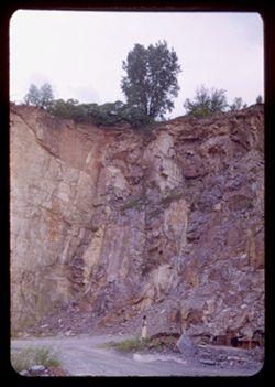
- Subject:
- Rocks, Roads, Women, Trees, Shrubs, and Cliffs
- Series:
- 8-50
- Creator:
- Cushman, Charles W., 1896-1972
- Date Created:
- 1950-07-18
- Frame Number:
- 13
- County:
- Sauk
- Abstract:
- Quarry at Rock Springs and Steep walls of old quarry near Rock Springs.
- Call Number:
- P04840
- City:
- Rock Springs
- Country:
- United States
- State/Province:
- Wisconsin
- Alternate Identifier:
- 850.13
- Persistent URL:
- http://purl.dlib.indiana.edu/iudl/archives/cushman/P04840
- Holding Location:
- Bloomington - University Archives
Wells Library E460
1320 E 10th St.
Bloomington, IN 47405
Contact at archives@indiana.edu, 812-855-1127
-
- Description:
- 50 f 9
- Subject:
- Rocks, Grasses, Roads, Tree limbs, Mountains, Rock formations, and Shrubs
- Series:
- 14-53
- Creator:
- Cushman, Charles W., 1896-1972
- Date Created:
- 1953-11-19
- Genre:
- Landscape photographs
- Frame Number:
- 22
- Street Address:
- United States Highway 60 and United States Highway 70
- County:
- Pinal
- Abstract:
- a stretch of the old highway
- Call Number:
- P07018
- City:
- Superior
- Country:
- United States
- State/Province:
- Arizona
- Alternate Identifier:
- 1453.22
- Persistent URL:
- http://purl.dlib.indiana.edu/iudl/archives/cushman/P07018
- Holding Location:
- Bloomington - University Archives
Wells Library E460
1320 E 10th St.
Bloomington, IN 47405
Contact at archives@indiana.edu, 812-855-1127
-
- Subject:
- Rocks, Roads, Trees, Shadows, Mountains, Shrubs, and Clouds
- Series:
- 14-40
- Creator:
- Cushman, Charles W., 1896-1972
- Date Created:
- 1940-07-19
- Genre:
- Landscape photographs
- Frame Number:
- 8
- County:
- El Paso
- Abstract:
- Clouds and mountains near Colorado Springs.
- Call Number:
- P02026
- City:
- Colorado Springs
- Country:
- United States
- State/Province:
- Colorado
- Physical Description:
- Image was originally mounted in a glass enclosure. Before digitization, the image was removed and placed in a Wess Plastic, Inc. brand, 2" x 2", pl...
- Alternate Identifier:
- 1440.8
- Persistent URL:
- http://purl.dlib.indiana.edu/iudl/archives/cushman/P02026
- Holding Location:
- Bloomington - University Archives
Wells Library E460
1320 E 10th St.
Bloomington, IN 47405
Contact at archives@indiana.edu, 812-855-1127
-
- Description:
- 100 f 6.3 tl
- Subject:
- Rocks, Roads, Trails & paths, Mountains, Shrubs, Alabama Hills (Calif.), and Rock formations
- Series:
- 4-55
- Creator:
- Cushman, Charles W., 1896-1972
- Date Created:
- 1955-02-28
- Genre:
- Landscape photographs
- Frame Number:
- 1
- Street Address:
- Mount Whitney Road
- County:
- Inyo
- Abstract:
- Alabama Hills from Mt Whitney road
- Call Number:
- P07630
- Country:
- United States
- State/Province:
- California
- Alternate Identifier:
- 455.1
- Persistent URL:
- http://purl.dlib.indiana.edu/iudl/archives/cushman/P07630
- Holding Location:
- Bloomington - University Archives
Wells Library E460
1320 E 10th St.
Bloomington, IN 47405
Contact at archives@indiana.edu, 812-855-1127
-
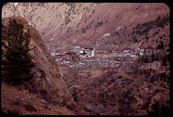
- Description:
- 25 f 4
- Subject:
- Rocks, Rocky Mountains, Valleys, Houses, Trees, Mountains, Buildings, Shrubs, Utility poles, Roads, and Cliffs
- Series:
- 25-52
- Creator:
- Cushman, Charles W., 1896-1972
- Date Created:
- 1952-11-01
- Genre:
- Cityscape photographs
- Frame Number:
- 12
- County:
- Clear Creek
- Abstract:
- Georgetown.
- Call Number:
- P06381
- City:
- Georgetown
- Country:
- United States
- State/Province:
- Colorado
- Alternate Identifier:
- 2552.12
- Persistent URL:
- http://purl.dlib.indiana.edu/iudl/archives/cushman/P06381
- Holding Location:
- Bloomington - University Archives
Wells Library E460
1320 E 10th St.
Bloomington, IN 47405
Contact at archives@indiana.edu, 812-855-1127
-
- Description:
- 50 f 11
- Subject:
- Rocks, Roads, Dirt, Mountains, Shrubs, Clouds, Forests, and Shadows
- Series:
- 8-53
- Creator:
- Cushman, Charles W., 1896-1972
- Date Created:
- 1953-10-09
- Genre:
- Views
- Frame Number:
- 35
- Street Address:
- United States Highway 50
- County:
- Carson City
- Abstract:
- Looking back.
- Call Number:
- P06797
- City:
- Carson City
- Country:
- United States
- State/Province:
- Nevada
- Alternate Identifier:
- 853.35
- Persistent URL:
- http://purl.dlib.indiana.edu/iudl/archives/cushman/P06797
- Holding Location:
- Bloomington - University Archives
Wells Library E460
1320 E 10th St.
Bloomington, IN 47405
Contact at archives@indiana.edu, 812-855-1127
-
- Description:
- 100 f 6.3 SL
- Subject:
- Walls, Railings, Roads, Automobiles, Trees, Mountains, Shrubs, Sierra Nevada (Calif. and Nev.), Stone walls, Rocks, Houses, and Echo Summit (El Dorado County...
- Series:
- 3-62
- Creator:
- Cushman, Charles W., 1896-1972
- Date Created:
- 1962-09-28
- Genre:
- Landscape photographs
- Frame Number:
- 7
- Street Address:
- United States Highway 50
- Abstract:
- Wall above US 50.
- Call Number:
- P12705
- Country:
- United States
- State/Province:
- California
- Alternate Identifier:
- 362.7
- Persistent URL:
- http://purl.dlib.indiana.edu/iudl/archives/cushman/P12705
- Holding Location:
- Bloomington - University Archives
Wells Library E460
1320 E 10th St.
Bloomington, IN 47405
Contact at archives@indiana.edu, 812-855-1127
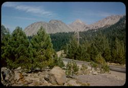
-
- Description:
- 100 f 6.3 TL
- Subject:
- Rocks, Roads, Trees, Mountains, Shrubs, Lakes & ponds, Clouds, Sierra Nevada (Calif. and Nev.), Forests, Hills, Echo Summit (El Dorado County, Calif.), a...
- Series:
- 3-62
- Creator:
- Cushman, Charles W., 1896-1972
- Date Created:
- 1962-09-28
- Genre:
- Landscape photographs
- Frame Number:
- 11
- Street Address:
- United States Highway 50
- Abstract:
- Toward Lake Tahoe.
- Call Number:
- P12709
- Country:
- United States
- State/Province:
- California
- Alternate Identifier:
- 362.11
- Persistent URL:
- http://purl.dlib.indiana.edu/iudl/archives/cushman/P12709
- Holding Location:
- Bloomington - University Archives
Wells Library E460
1320 E 10th St.
Bloomington, IN 47405
Contact at archives@indiana.edu, 812-855-1127
-
- Subject:
- Rocks, Roads, Trees, Mountains, Shrubs, Zion National Park (Utah), and National parks & reserves
- Series:
- 11-40
- Creator:
- Cushman, Charles W., 1896-1972
- Date Created:
- 1940-07-11
- Genre:
- Landscape photographs
- Frame Number:
- 14
- Street Address:
- Mt. Carmel Road
- County:
- Washington
- Abstract:
- Mt. Carmel Road - east of Zion tunnel.
- Call Number:
- P01973
- Country:
- United States
- State/Province:
- Utah
- Physical Description:
- Image was originally mounted in a glass enclosure. Before digitization, the image was removed and placed in a Wess Plastic, Inc. brand, 2" x 2", pl...
- Alternate Identifier:
- 1140.14
- Persistent URL:
- http://purl.dlib.indiana.edu/iudl/archives/cushman/P01973
- Holding Location:
- Bloomington - University Archives
Wells Library E460
1320 E 10th St.
Bloomington, IN 47405
Contact at archives@indiana.edu, 812-855-1127
-
- Description:
- 50 f 6.3
- Subject:
- Rocks, Roads, Feather River (Calif.), Trees, Railroad bridges, Western Pacific Railroad Company, Arches, Mountains, Shrubs, Truss bridges, Bridges, Railroads...
- Series:
- 7-54
- Creator:
- Cushman, Charles W., 1896-1972
- Date Created:
- 1954-08-22
- Genre:
- Landscape photographs
- Frame Number:
- 30
- County:
- Butte
- Abstract:
- Rapids below Arch bridge + WPRR bridge.
- Call Number:
- P07285
- City:
- Pulga
- Country:
- United States
- State/Province:
- California
- Alternate Identifier:
- 754.30
- Persistent URL:
- http://purl.dlib.indiana.edu/iudl/archives/cushman/P07285
- Holding Location:
- Bloomington - University Archives
Wells Library E460
1320 E 10th St.
Bloomington, IN 47405
Contact at archives@indiana.edu, 812-855-1127
-
- Description:
- 50 f 5.6 Pola
- Subject:
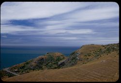
- Rocks, Oceans, Stinson Beach (Calif.), Roads, Shrubs, Clouds, and Hills
- Series:
- 6-53
- Creator:
- Cushman, Charles W., 1896-1972
- Date Created:
- 1953-06-05
- Genre:
- Landscape photographs
- Frame Number:
- 37
- County:
- Marin
- Abstract:
- Nearby - Along Coast Hwy 1 south of Stinson Beach.
- Call Number:
- P06725
- Country:
- United States
- State/Province:
- California
- Alternate Identifier:
- 653.37
- Persistent URL:
- http://purl.dlib.indiana.edu/iudl/archives/cushman/P06725
- Holding Location:
- Bloomington - University Archives
Wells Library E460
1320 E 10th St.
Bloomington, IN 47405
Contact at archives@indiana.edu, 812-855-1127
-
- Description:
- 100 f 8 tl
- Subject:
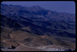
- Rocks, Valleys, Roads, Argus Range (Calif.), Emigrant Pass (Inyo County, Calif.), Mountains, Shrubs, and Panamint Valley (Calif.)
- Series:
- 7-55
- Creator:
- Cushman, Charles W., 1896-1972
- Date Created:
- 1955-03-21
- Genre:
- Landscape photographs
- Frame Number:
- 34
- County:
- Inyo
- Abstract:
- NW along Argus mtns at west side of Panamint Valley from Emigrant pass.
- Call Number:
- P07758
- Country:
- United States
- State/Province:
- California
- Alternate Identifier:
- 755.34
- Persistent URL:
- http://purl.dlib.indiana.edu/iudl/archives/cushman/P07758
- Holding Location:
- Bloomington - University Archives
Wells Library E460
1320 E 10th St.
Bloomington, IN 47405
Contact at archives@indiana.edu, 812-855-1127
-
- Description:
- 25 f 9
- Subject:
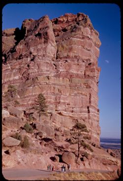
- Rocks, Roads, Parks, Trees, Boulders, Buttes, Shrubs, Red Rocks Park (Jefferson County, Colo.), People, Cliffs, Rock formations, and Red beds
- Series:
- 24-52
- Creator:
- Cushman, Charles W., 1896-1972
- Date Created:
- 1952-10-30
- Genre:
- Landscape photographs
- Frame Number:
- 3
- County:
- Jefferson
- Persons Pictured:
- Cushman, Charles W. (Charles Weever), 1896-1972
- Abstract:
- Great Tall red rock
- Call Number:
- P06334
- City:
- Morrison
- Country:
- United States
- State/Province:
- Colorado
- Alternate Identifier:
- 2452.3
- Persistent URL:
- http://purl.dlib.indiana.edu/iudl/archives/cushman/P06334
- Holding Location:
- Bloomington - University Archives
Wells Library E460
1320 E 10th St.
Bloomington, IN 47405
Contact at archives@indiana.edu, 812-855-1127
-
- Description:
- 25 f 5.6 Pola
- Subject:
- Rocks, Roads, Trees, Boulders, Mountains, Buildings, and Shrubs
- Series:
- 23-52
- Creator:
- Cushman, Charles W., 1896-1972
- Date Created:
- 1952-01-01
- Genre:
- Landscape photographs
- Frame Number:
- 21
- Street Address:
- Skyline Drive
- County:
- Fremont
- Abstract:
- Across Canon City form Skyline Drive
- Call Number:
- P06313
- City:
- Canon City
- Country:
- United States
- State/Province:
- Colorado
- Alternate Identifier:
- 2352.21
- Persistent URL:
- http://purl.dlib.indiana.edu/iudl/archives/cushman/P06313
- Holding Location:
- Bloomington - University Archives
Wells Library E460
1320 E 10th St.
Bloomington, IN 47405
Contact at archives@indiana.edu, 812-855-1127
- « Previous
- Next »
- 1
- 2
- 3