
Search Constraints
You searched for:
Campus
IUB
Remove constraint Campus: IUB
Pages
0-99 pages
Remove constraint Pages: 0-99 pages
State/Province
Arizona
Remove constraint State/Province: Arizona
Search Results
-
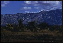
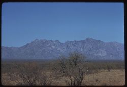
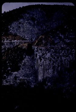
- Description:
- 100 f 8 tl
- Subject:
- Snow, Trees, Mountains, Shrubs, Clouds, and Santa Catalina Mountains (Ariz.)
- Series:
- 7-59
- Creator:
- Cushman, Charles W., 1896-1972
- Date Created:
- 1959-02-03
- Genre:
- Landscape photographs
- Frame Number:
- 14
- County:
- Pinal
- Abstract:
- Santa Catalina Mtns
- Call Number:
- P10590
- City:
- Oracle Junction
- Country:
- United States
- State/Province:
- Arizona
- Alternate Identifier:
- 759.14
- Persistent URL:
- http://purl.dlib.indiana.edu/iudl/archives/cushman/P10590
-
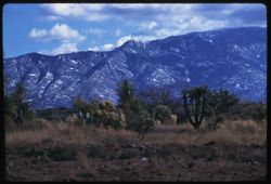
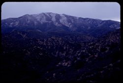
- Description:
- 100 f 5.6 tl
- Subject:
- Snow, Cactus, Trees, Mountains, Shrubs, Clouds, and Santa Catalina Mountains (Ariz.)
- Series:
- 7-59
- Creator:
- Cushman, Charles W., 1896-1972
- Date Created:
- 1959-02-03
- Genre:
- Landscape photographs
- Frame Number:
- 15
- County:
- Pinal
- Abstract:
- Santa Catalina Mtns
- Call Number:
- P10591
- City:
- Oracle Junction
- Country:
- United States
- State/Province:
- Arizona
- Alternate Identifier:
- 759.15
- Persistent URL:
- http://purl.dlib.indiana.edu/iudl/archives/cushman/P10591
-

- Description:
- 100 f 6.3 tl
- Subject:
- Children & adults, Stores & shops, Mothers & children, Trees, Signs (Notices), Streets, Mountains, and Shrubs
- Series:
- 7-59
- Creator:
- Cushman, Charles W., 1896-1972
- Date Created:
- 1959-02-03
- Genre:
- Snapshots
- Frame Number:
- 13
- County:
- Pinal
- Abstract:
- Little girl + mama
- Call Number:
- P10589
- City:
- Mammoth
- Country:
- United States
- State/Province:
- Arizona
- Alternate Identifier:
- 759.13
- Persistent URL:
- http://purl.dlib.indiana.edu/iudl/archives/cushman/P10589
-
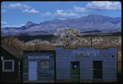
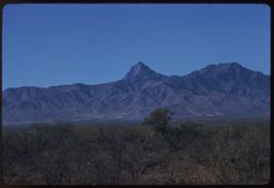
- Description:
- 100 f 6.3 tl
- Subject:
- Stores & shops, Electric lines, Trees, Signs (Notices), Cities & towns, Buildings, Shrubs, Clouds, Windows, Doors & doorways, Galiuro Mountains (...
- Series:
- 7-59
- Creator:
- Cushman, Charles W., 1896-1972
- Date Created:
- 1959-02-03
- Genre:
- Landscape photographs
- Frame Number:
- 12
- County:
- Pinal
- Abstract:
- Galiuro Mtns. From Mammoth Ariz.
- Call Number:
- P10588
- City:
- Mammoth
- Country:
- United States
- State/Province:
- Arizona
- Alternate Identifier:
- 759.12
- Persistent URL:
- http://purl.dlib.indiana.edu/iudl/archives/cushman/P10588
-
- Description:
- 100 f 6.3
- Subject:
- San Pedro River (Mexico and Ariz.), Galiuro Mountains (Ariz.), Cactus, Mountains, Shrubs, and Clouds
- Series:
- 7-59
- Creator:
- Cushman, Charles W., 1896-1972
- Date Created:
- 1959-02-03
- Genre:
- Landscape photographs
- Frame Number:
- 11
- County:
- Pinal
- Abstract:
- Galiuro Mtns. across San Pedro river from S. Manuel
- Call Number:
- P10587
- City:
- San Manuel
- Country:
- United States
- State/Province:
- Arizona
- Alternate Identifier:
- 759.11
- Persistent URL:
- http://purl.dlib.indiana.edu/iudl/archives/cushman/P10587
-
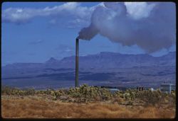
- Description:
- 100 f 8 tl
- Subject:
- Galiuro Mountains (Ariz.), Smokestacks, Mills, Smoke, Magma Copper Company, Mountains, Shrubs, Trees, Buildings, and Clouds
- Series:
- 7-59
- Creator:
- Cushman, Charles W., 1896-1972
- Date Created:
- 1959-02-03
- Genre:
- Landscape photographs
- Frame Number:
- 10
- County:
- Pinal
- Abstract:
- Magma Copper Co. mill at San Manuel
- Call Number:
- P10586
- City:
- San Manuel
- Country:
- United States
- State/Province:
- Arizona
- Alternate Identifier:
- 759.10
- Persistent URL:
- http://purl.dlib.indiana.edu/iudl/archives/cushman/P10586
-
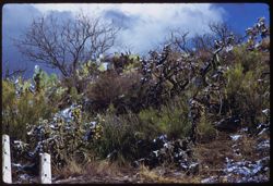
- Description:
- 50 f 11 tl
- Subject:
- Snow, Cactus, Trees, Flowers, Fences, Shrubs, Clouds, and Santa Catalina Mountains (Ariz.)
- Series:
- 7-59
- Creator:
- Cushman, Charles W., 1896-1972
- Date Created:
- 1959-02-03
- Genre:
- Identification photographs
- Frame Number:
- 8
- County:
- Pinal
- Abstract:
- Top of the rise
- Call Number:
- P10584
- City:
- Oracle
- Country:
- United States
- State/Province:
- Arizona
- Alternate Identifier:
- 759.8
- Persistent URL:
- http://purl.dlib.indiana.edu/iudl/archives/cushman/P10584
-
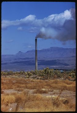
- Description:
- 100 f 8 tl
- Subject:
- Mills, Trees, Smoke, Magma Copper Company, Mountains, Buildings, Shrubs, Clouds, and Smokestacks
- Series:
- 7-59
- Creator:
- Cushman, Charles W., 1896-1972
- Date Created:
- 1959-02-03
- Genre:
- Landscape photographs
- Frame Number:
- 9
- County:
- Pinal
- Abstract:
- Magma Copper Co. mill at San Manuel
- Call Number:
- P10585
- City:
- San Manuel
- Country:
- United States
- State/Province:
- Arizona
- Alternate Identifier:
- 759.9
- Persistent URL:
- http://purl.dlib.indiana.edu/iudl/archives/cushman/P10585
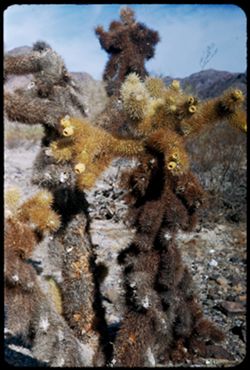
-
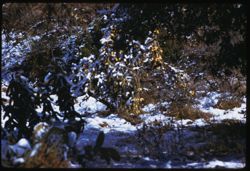
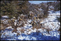
- Description:
- 50 f 9 tl
- Subject:
- Snow, Flowers, Shrubs, Santa Catalina Mountains (Ariz.), and Cholla
- Series:
- 7-59
- Creator:
- Cushman, Charles W., 1896-1972
- Date Created:
- 1959-02-03
- Genre:
- Identification photographs
- Frame Number:
- 7
- County:
- Pinal
- Abstract:
- Snow on the Cholla at Oracle
- Call Number:
- P10583
- City:
- Oracle
- Country:
- United States
- State/Province:
- Arizona
- Alternate Identifier:
- 759.7
- Persistent URL:
- http://purl.dlib.indiana.edu/iudl/archives/cushman/P10583
-
- Description:
- 25 f 11 s
- Subject:
- Flowers, Shrubs, Santa Catalina Mountains (Ariz.), Trees, Cholla, and Snow
- Series:
- 7-59
- Creator:
- Cushman, Charles W., 1896-1972
- Date Created:
- 1959-02-03
- Genre:
- Identification photographs
- Frame Number:
- 6
- County:
- Pinal
- Abstract:
- Snow on the Cholla at Oracle
- Call Number:
- P10582
- City:
- Oracle
- Country:
- United States
- State/Province:
- Arizona
- Alternate Identifier:
- 759.6
- Persistent URL:
- http://purl.dlib.indiana.edu/iudl/archives/cushman/P10582
-
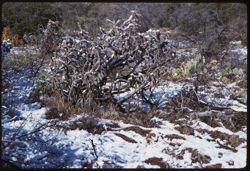
- Description:
- 25 f 9 sl
- Subject:
- Snow, Cactus, Flowers, Shrubs, Santa Catalina Mountains (Ariz.), and Cholla
- Series:
- 7-59
- Creator:
- Cushman, Charles W., 1896-1972
- Date Created:
- 1959-02-03
- Genre:
- Identification photographs
- Frame Number:
- 5
- County:
- Pinal
- Abstract:
- Snow on the Cholla at Oracle
- Call Number:
- P10581
- City:
- Oracle
- Country:
- United States
- State/Province:
- Arizona
- Alternate Identifier:
- 759.5
- Persistent URL:
- http://purl.dlib.indiana.edu/iudl/archives/cushman/P10581
-
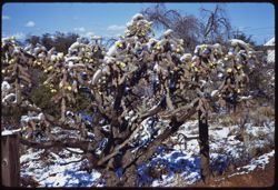
- Description:
- 25 f 11 sl
- Subject:
- Snow, Trees, Flowers, Fences, Shrubs, Clouds, Santa Catalina Mountains (Ariz.), and Cholla
- Series:
- 7-59
- Creator:
- Cushman, Charles W., 1896-1972
- Date Created:
- 1959-02-03
- Genre:
- Identification photographs
- Frame Number:
- 4
- County:
- Pinal
- Abstract:
- Snow on the Cholla at Oracle
- Call Number:
- P10580
- City:
- Oracle
- Country:
- United States
- State/Province:
- Arizona
- Alternate Identifier:
- 759.4
- Persistent URL:
- http://purl.dlib.indiana.edu/iudl/archives/cushman/P10580
-
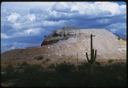
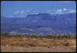
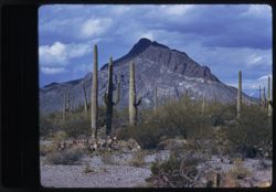
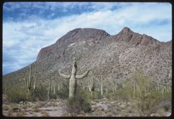
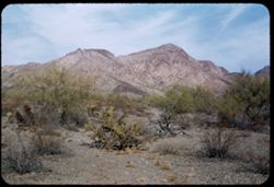
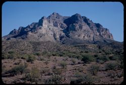
- Description:
- 100 f 8 tl
- Subject:
- Rocks, Cactus, Buttes, Mountains, Shrubs, Tucson Mountains (Ariz.), and Clouds
- Series:
- 7-59
- Creator:
- Cushman, Charles W., 1896-1972
- Date Created:
- 1959-02-02
- Genre:
- Landscape photographs
- Frame Number:
- 3
- Street Address:
- Ajo Way
- County:
- Pima
- Abstract:
- A small butte commercialized
- Call Number:
- P10579
- City:
- Tucson
- Country:
- United States
- State/Province:
- Arizona
- Alternate Identifier:
- 759.3
- Persistent URL:
- http://purl.dlib.indiana.edu/iudl/archives/cushman/P10579
-
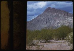
- Description:
- 100 f 8
- Subject:
- Mountains, Tucson Mountains (Ariz.), Shrubs, Cactus, and Clouds
- Series:
- 7-59
- Creator:
- Cushman, Charles W., 1896-1972
- Date Created:
- 1959-02-02
- Genre:
- Landscape photographs
- Frame Number:
- 2
- Street Address:
- Ajo Way
- County:
- Pima
- Abstract:
- a Tucson mtn. from SE
- Call Number:
- P10578
- City:
- Tucson
- Country:
- United States
- State/Province:
- Arizona
- Physical Description:
- masked.
- Alternate Identifier:
- 759.2
- Persistent URL:
- http://purl.dlib.indiana.edu/iudl/archives/cushman/P10578
-
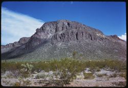
- Description:
- 100 f 8 tl
- Subject:
- Mountains, Tucson Mountains (Ariz.), Shrubs, and Clouds
- Series:
- 7-59
- Creator:
- Cushman, Charles W., 1896-1972
- Date Created:
- 1959-02-02
- Genre:
- Landscape photographs
- Frame Number:
- 1
- Street Address:
- Ajo Way
- County:
- Pinal
- Abstract:
- a Tucson mtn.
- Call Number:
- P10577
- City:
- Tucson
- Country:
- United States
- State/Province:
- Arizona
- Physical Description:
- masked.
- Alternate Identifier:
- 759.1
- Persistent URL:
- http://purl.dlib.indiana.edu/iudl/archives/cushman/P10577
-
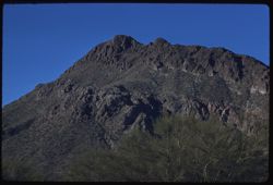
- Description:
- 50 f 8 sl
- Subject:
- Mountains, Shrubs, Tucson Mountains (Ariz.), Clouds, and Cat Mountain (Ariz.)
- Series:
- 6-59
- Creator:
- Cushman, Charles W., 1896-1972
- Date Created:
- 1959-01-28
- Genre:
- Landscape photographs
- Frame Number:
- 38
- County:
- Pima
- Abstract:
- Cat Mtn from west
- Call Number:
- P10576
- City:
- Tucson
- Country:
- United States
- State/Province:
- Arizona
- Alternate Identifier:
- 659.38
- Persistent URL:
- http://purl.dlib.indiana.edu/iudl/archives/cushman/P10576
-
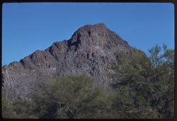
- Description:
- 50 f 9 sl
- Subject:
- Cactus, Mountains, Shrubs, Tucson Mountains (Ariz.), Clouds, and Cat Mountain (Ariz.)
- Series:
- 6-59
- Creator:
- Cushman, Charles W., 1896-1972
- Date Created:
- 1959-02-02
- Genre:
- Landscape photographs
- Frame Number:
- 37
- County:
- Pima
- Abstract:
- Cat Mtn from S.E.
- Call Number:
- P10575
- City:
- Tucson
- Country:
- United States
- State/Province:
- Arizona
- Alternate Identifier:
- 659.37
- Persistent URL:
- http://purl.dlib.indiana.edu/iudl/archives/cushman/P10575
-
- Description:
- 100 f 8 tl
- Subject:
- Electric lines, Trees, Mountains, Shrubs, Santa Rita Mountains (Ariz.), Dwellings, and Hills
- Series:
- 6-59
- Creator:
- Cushman, Charles W., 1896-1972
- Date Created:
- 1959-01-28
- Genre:
- Landscape photographs
- Frame Number:
- 35
- Street Address:
- Arivara Road
- Abstract:
- Sugarloaf in Santa Rita Mtn foothills - from Arivara rd.
- Call Number:
- P10573
- Country:
- United States
- State/Province:
- Arizona
- Alternate Identifier:
- 659.35
- Persistent URL:
- http://purl.dlib.indiana.edu/iudl/archives/cushman/P10573
-
- Description:
- 100 f 8 tl
- Subject:
- Cerro Colorado Mountains (Ariz.), Mountains, and Shrubs
- Series:
- 6-59
- Creator:
- Cushman, Charles W., 1896-1972
- Date Created:
- 1959-01-28
- Genre:
- Landscape photographs
- Frame Number:
- 34
- County:
- Pima
- Abstract:
- Cerro Colorado from SW farther on
- Call Number:
- P10572
- Country:
- United States
- State/Province:
- Arizona
- Alternate Identifier:
- 659.34
- Persistent URL:
- http://purl.dlib.indiana.edu/iudl/archives/cushman/P10572
-
- Description:
- 100 f 8 tl
- Subject:
- Roads, Cerro Colorado Mountains (Ariz.), Mountains, and Shrubs
- Series:
- 6-59
- Creator:
- Cushman, Charles W., 1896-1972
- Date Created:
- 1959-01-28
- Genre:
- Landscape photographs
- Frame Number:
- 33
- County:
- Pima
- Abstract:
- Cerro Colorado from SW farther on
- Call Number:
- P10571
- Country:
- United States
- State/Province:
- Arizona
- Alternate Identifier:
- 659.33
- Persistent URL:
- http://purl.dlib.indiana.edu/iudl/archives/cushman/P10571
-
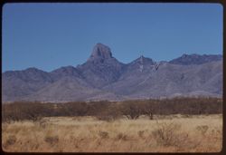
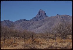
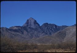
- Description:
- 100 f 8 tl
- Subject:
- Rocks, Baboquivari Peak (Ariz.), Mountains, and Shrubs
- Series:
- 6-59
- Creator:
- Cushman, Charles W., 1896-1972
- Date Created:
- 1959-01-28
- Genre:
- Landscape photographs
- Frame Number:
- 32
- County:
- Pima
- Abstract:
- Babo head & shoulders from far
- Call Number:
- P10570
- Country:
- United States
- State/Province:
- Arizona
- Alternate Identifier:
- 659.32
- Persistent URL:
- http://purl.dlib.indiana.edu/iudl/archives/cushman/P10570
-
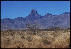
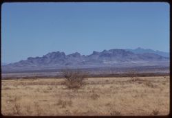
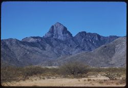
- Description:
- 100 f 9 tl
- Subject:
- Baboquivari Peak (Ariz.), Mountains, and Shrubs
- Series:
- 6-59
- Creator:
- Cushman, Charles W., 1896-1972
- Date Created:
- 1959-01-28
- Genre:
- Landscape photographs
- Frame Number:
- 31
- County:
- Pima
- Abstract:
- Babo head & shoulders
- Call Number:
- P10569
- Country:
- United States
- State/Province:
- Arizona
- Alternate Identifier:
- 659.31
- Persistent URL:
- http://purl.dlib.indiana.edu/iudl/archives/cushman/P10569
-
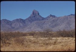
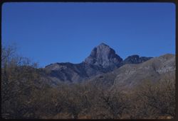
- Description:
- 100 f 8 tl
- Subject:
- Baboquivari Peak (Ariz.), Mountains, and Shrubs
- Series:
- 6-59
- Creator:
- Cushman, Charles W., 1896-1972
- Date Created:
- 1959-01-28
- Genre:
- Landscape photographs
- Frame Number:
- 30
- County:
- Pima
- Abstract:
- Babo head & shoulders
- Call Number:
- P10568
- Country:
- United States
- State/Province:
- Arizona
- Alternate Identifier:
- 659.30
- Persistent URL:
- http://purl.dlib.indiana.edu/iudl/archives/cushman/P10568
-
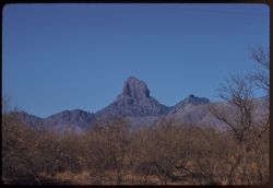
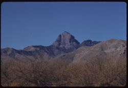
- Description:
- 100 f 8 tl
- Subject:
- Baboquivari Peak (Ariz.), Mountains, Fences, and Shrubs
- Series:
- 6-59
- Creator:
- Cushman, Charles W., 1896-1972
- Date Created:
- 1959-01-28
- Genre:
- Landscape photographs
- Frame Number:
- 29
- County:
- Pima
- Abstract:
- Babo head & shoulders
- Call Number:
- P10567
- Country:
- United States
- State/Province:
- Arizona
- Alternate Identifier:
- 659.29
- Persistent URL:
- http://purl.dlib.indiana.edu/iudl/archives/cushman/P10567
-
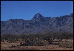
- Description:
- 100 f 8 tl
- Subject:
- Baboquivari Peak (Ariz.), Mountains, and Shrubs
- Series:
- 6-59
- Creator:
- Cushman, Charles W., 1896-1972
- Date Created:
- 1959-01-28
- Genre:
- Landscape photographs
- Frame Number:
- 28
- County:
- Pima
- Abstract:
- Babo head & shoulders
- Call Number:
- P10566
- Country:
- United States
- State/Province:
- Arizona
- Alternate Identifier:
- 659.28
- Persistent URL:
- http://purl.dlib.indiana.edu/iudl/archives/cushman/P10566
-
- Description:
- 100 f 8 tl
- Subject:
- Baboquivari Peak (Ariz.), Mountains, Fences, and Shrubs
- Series:
- 6-59
- Creator:
- Cushman, Charles W., 1896-1972
- Date Created:
- 1959-01-28
- Genre:
- Landscape photographs
- Frame Number:
- 27
- County:
- Pima
- Abstract:
- Babo
- Call Number:
- P10565
- Country:
- United States
- State/Province:
- Arizona
- Alternate Identifier:
- 659.27
- Persistent URL:
- http://purl.dlib.indiana.edu/iudl/archives/cushman/P10565
-
- Description:
- 100 f 8 tl
- Subject:
- Altar River Valley (Mexico), Cerro Colorado Mountains (Ariz.), Mountains, and Shrubs
- Series:
- 6-59
- Creator:
- Cushman, Charles W., 1896-1972
- Date Created:
- 1959-01-28
- Genre:
- Landscape photographs
- Frame Number:
- 26
- County:
- Pima
- Abstract:
- Cerro Colorado Mtns from across Altar valley
- Call Number:
- P10564
- Country:
- United States
- State/Province:
- Arizona
- Alternate Identifier:
- 659.26
- Persistent URL:
- http://purl.dlib.indiana.edu/iudl/archives/cushman/P10564
-
- Description:
- 100 f 8 tl
- Subject:
- Altar River Valley (Mexico), Sierrita Mountains (Ariz.), Mountains, and Shrubs
- Series:
- 6-59
- Creator:
- Cushman, Charles W., 1896-1972
- Date Created:
- 1959-01-28
- Genre:
- Landscape photographs
- Frame Number:
- 25
- County:
- Pima
- Abstract:
- Sierrita Mtns. seen from SW
- Call Number:
- P10563
- Country:
- United States
- State/Province:
- Arizona
- Alternate Identifier:
- 659.25
- Persistent URL:
- http://purl.dlib.indiana.edu/iudl/archives/cushman/P10563
-
- Description:
- 100 f 8 tl
- Subject:
- Baboquivari Peak (Ariz.), Mountains, and Shrubs
- Series:
- 6-59
- Creator:
- Cushman, Charles W., 1896-1972
- Date Created:
- 1959-01-28
- Genre:
- Landscape photographs
- Frame Number:
- 24
- County:
- Pima
- Abstract:
- Baboquivari from SSE
- Call Number:
- P10562
- Country:
- United States
- State/Province:
- Arizona
- Alternate Identifier:
- 659.24
- Persistent URL:
- http://purl.dlib.indiana.edu/iudl/archives/cushman/P10562
-
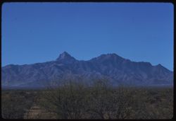
- Description:
- 100 f 6.3 t
- Subject:
- Baboquivari Peak (Ariz.), Mountains, and Shrubs
- Series:
- 6-59
- Creator:
- Cushman, Charles W., 1896-1972
- Date Created:
- 1959-01-28
- Genre:
- Landscape photographs
- Frame Number:
- 23
- County:
- Pima
- Abstract:
- Baboquivari from SSE
- Call Number:
- P10561
- Country:
- United States
- State/Province:
- Arizona
- Alternate Identifier:
- 659.23
- Persistent URL:
- http://purl.dlib.indiana.edu/iudl/archives/cushman/P10561
-
- Description:
- 100 f 8 tl
- Subject:
- Baboquivari Peak (Ariz.), Mountains, and Shrubs
- Series:
- 6-59
- Creator:
- Cushman, Charles W., 1896-1972
- Date Created:
- 1959-01-28
- Genre:
- Landscape photographs
- Frame Number:
- 22
- County:
- Pima
- Abstract:
- Baboquivari from [S] E
- Call Number:
- P10560
- Country:
- United States
- State/Province:
- Arizona
- Alternate Identifier:
- 659.22
- Persistent URL:
- http://purl.dlib.indiana.edu/iudl/archives/cushman/P10560
-
- Description:
- 100 f 8 tl
- Subject:
- Baboquivari Peak (Ariz.), Mountains, and Shrubs
- Series:
- 6-59
- Creator:
- Cushman, Charles W., 1896-1972
- Date Created:
- 1959-01-28
- Genre:
- Landscape photographs
- Frame Number:
- 21
- County:
- Pima
- Abstract:
- Baboquivari from [S] E
- Call Number:
- P10559
- Country:
- United States
- State/Province:
- Arizona
- Alternate Identifier:
- 659.21
- Persistent URL:
- http://purl.dlib.indiana.edu/iudl/archives/cushman/P10559
-
- Description:
- 100 f 8 tl
- Subject:
- Baboquivari Peak (Ariz.), Mountains, and Shrubs
- Series:
- 6-59
- Creator:
- Cushman, Charles W., 1896-1972
- Date Created:
- 1959-01-28
- Genre:
- Landscape photographs
- Frame Number:
- 20
- County:
- Pima
- Abstract:
- Baboquivari
- Call Number:
- P10558
- Country:
- United States
- State/Province:
- Arizona
- Alternate Identifier:
- 659.20
- Persistent URL:
- http://purl.dlib.indiana.edu/iudl/archives/cushman/P10558
-
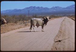
- Description:
- 100 f 6.3 tl
- Subject:
- Channels, Brawley Wash (Ariz.), Roads, Mountains, Shrubs, Electric lines, and Bulls
- Series:
- 6-59
- Creator:
- Cushman, Charles W., 1896-1972
- Date Created:
- 1959-01-28
- Genre:
- Identification photographs
- Frame Number:
- 19
- Street Address:
- Sasabe Road
- County:
- Pima
- Abstract:
- One B B
- Call Number:
- P10557
- Country:
- United States
- State/Province:
- Arizona
- Alternate Identifier:
- 659.19
- Persistent URL:
- http://purl.dlib.indiana.edu/iudl/archives/cushman/P10557
-
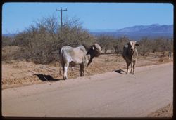
- Description:
- 100 f 6.3 tl
- Subject:
- Channels, Brawley Wash (Ariz.), Roads, Mountains, Shrubs, Electric lines, and Bulls
- Series:
- 6-59
- Creator:
- Cushman, Charles W., 1896-1972
- Date Created:
- 1959-01-28
- Genre:
- Identification photographs
- Frame Number:
- 18
- Street Address:
- Sasabe Road
- County:
- Pima
- Abstract:
- 2 Brahma bulls on Sasabe road
- Call Number:
- P10556
- Country:
- United States
- State/Province:
- Arizona
- Alternate Identifier:
- 659.18
- Persistent URL:
- http://purl.dlib.indiana.edu/iudl/archives/cushman/P10556
-
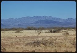
- Description:
- 100 f 9 tl
- Subject:
- Baboquivari Peak (Ariz.), Mountains, Shrubs, and Grasses
- Series:
- 6-59
- Creator:
- Cushman, Charles W., 1896-1972
- Date Created:
- 1959-01-28
- Genre:
- Landscape photographs
- Frame Number:
- 17
- County:
- Pima
- Abstract:
- Broadside view of Babo. range further north of PK.
- Call Number:
- P10555
- Country:
- United States
- State/Province:
- Arizona
- Alternate Identifier:
- 659.17
- Persistent URL:
- http://purl.dlib.indiana.edu/iudl/archives/cushman/P10555
-
- Description:
- 100 f 8 tl
- Subject:
- Baboquivari Peak (Ariz.), Mountains, and Shrubs
- Series:
- 6-59
- Creator:
- Cushman, Charles W., 1896-1972
- Date Created:
- 1959-01-28
- Genre:
- Landscape photographs
- Frame Number:
- 16
- County:
- Pima
- Abstract:
- Baboquivari from the east, from farther south (7864' elev)
- Call Number:
- P10554
- Country:
- United States
- State/Province:
- Arizona
- Alternate Identifier:
- 659.16
- Persistent URL:
- http://purl.dlib.indiana.edu/iudl/archives/cushman/P10554
-
- Description:
- 100 f 8 tl
- Subject:
- Baboquivari Peak (Ariz.), Mountains, and Shrubs
- Series:
- 6-59
- Creator:
- Cushman, Charles W., 1896-1972
- Date Created:
- 1959-01-28
- Genre:
- Landscape photographs
- Frame Number:
- 15
- County:
- Pima
- Abstract:
- Baboquivari from the east
- Call Number:
- P10553
- Country:
- United States
- State/Province:
- Arizona
- Alternate Identifier:
- 659.15
- Persistent URL:
- http://purl.dlib.indiana.edu/iudl/archives/cushman/P10553
-
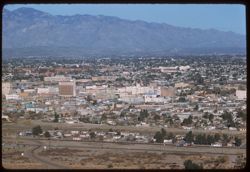
- Description:
- 100 f 6.3 tl
- Subject:
- Automobiles, Trees, Streets, Mountains, Buildings, Shrubs, Dwellings, and Cities & towns
- Series:
- 6-59
- Creator:
- Cushman, Charles W., 1896-1972
- Date Created:
- 1959-01-26
- Genre:
- Cityscape photographs
- Frame Number:
- 14
- County:
- Pima
- Abstract:
- Downtown Tucson seen from A Mountain
- Call Number:
- P10552
- City:
- Tucson
- Country:
- United States
- State/Province:
- Arizona
- Alternate Identifier:
- 659.14
- Persistent URL:
- http://purl.dlib.indiana.edu/iudl/archives/cushman/P10552
-
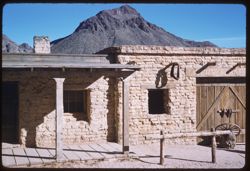
- Description:
- 100 f 8 tl
- Subject:
- Mud, Crosses, Adobe buildings, Mountains, Churches, Tucson Mountains (Ariz.), Masonry, Doors & doorways, and Windows
- Series:
- 6-59
- Creator:
- Cushman, Charles W., 1896-1972
- Date Created:
- 1959-01-26
- Genre:
- Architectural photographs
- Frame Number:
- 13
- County:
- Pima
- Abstract:
- Old Tucson - Mud Church
- Call Number:
- P10551
- City:
- Tucson
- Country:
- United States
- State/Province:
- Arizona
- Alternate Identifier:
- 659.13
- Persistent URL:
- http://purl.dlib.indiana.edu/iudl/archives/cushman/P10551
-
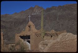
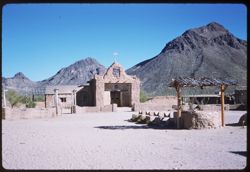
- Description:
- 100 f 9 tl
- Subject:
- Mud, Crosses, Cactus, Adobe buildings, Mountains, Churches, Shrubs, Tucson Mountains (Ariz.), and Walls
- Series:
- 6-59
- Creator:
- Cushman, Charles W., 1896-1972
- Date Created:
- 1959-01-26
- Genre:
- Architectural photographs
- Frame Number:
- 12
- County:
- Pima
- Abstract:
- Old Tucson - Mud Church
- Call Number:
- P10550
- City:
- Tucson
- Country:
- United States
- State/Province:
- Arizona
- Alternate Identifier:
- 659.12
- Persistent URL:
- http://purl.dlib.indiana.edu/iudl/archives/cushman/P10550
-
- Description:
- 50 f 8
- Subject:
- Motion pictures, Chimneys, Signs (Notices), Mountains, Tucson Mountains (Ariz.), Facilities, Columns, Wheels, Masonry, Windows, and Doors & doorways
- Series:
- 6-59
- Creator:
- Cushman, Charles W., 1896-1972
- Date Created:
- 1959-01-26
- Genre:
- Architectural photographs
- Frame Number:
- 11
- County:
- Pima
- Abstract:
- Mtn. back of Old Tucson
- Call Number:
- P10549
- City:
- Tucson
- Country:
- United States
- State/Province:
- Arizona
- Alternate Identifier:
- 659.11
- Persistent URL:
- http://purl.dlib.indiana.edu/iudl/archives/cushman/P10549
-
- Description:
- 50 f 8
- Subject:
- Motion pictures, Crosses, Mountains, Shrubs, Wells, Facilities, Tucson Mountains (Ariz.), and Masonry
- Series:
- 6-59
- Creator:
- Cushman, Charles W., 1896-1972
- Date Created:
- 1959-01-26
- Genre:
- Landscape photographs
- Frame Number:
- 10
- County:
- Pima
- Abstract:
- Old Tucson Movie Set
- Call Number:
- P10548
- City:
- Tucson
- Country:
- United States
- State/Province:
- Arizona
- Alternate Identifier:
- 659.10
- Persistent URL:
- http://purl.dlib.indiana.edu/iudl/archives/cushman/P10548
-
- Description:
- 50 f 8 sl
- Subject:
- Rocks, Cactus, Mountains, Shrubs, Tucson Mountains (Ariz.), and Gates Pass (Ariz.)
- Series:
- 6-59
- Creator:
- Cushman, Charles W., 1896-1972
- Date Created:
- 1959-01-26
- Genre:
- Landscape photographs
- Frame Number:
- 9
- County:
- Pima
- Abstract:
- from Gates Pass northward
- Call Number:
- P10547
- City:
- Tucson
- Country:
- United States
- State/Province:
- Arizona
- Alternate Identifier:
- 659.9
- Persistent URL:
- http://purl.dlib.indiana.edu/iudl/archives/cushman/P10547
-
- Description:
- 50 f 8 sl
- Subject:
- Mountains, Tucson Mountains (Ariz.), Shrubs, Cactus, Rocks, and Gates Pass (Ariz.)
- Series:
- 6-59
- Creator:
- Cushman, Charles W., 1896-1972
- Date Created:
- 1959-01-26
- Genre:
- Landscape photographs
- Frame Number:
- 8
- County:
- Pima
- Abstract:
- Tucson Mtns. - up from Gates Pass
- Call Number:
- P10546
- City:
- Tucson
- Country:
- United States
- State/Province:
- Arizona
- Alternate Identifier:
- 659.8
- Persistent URL:
- http://purl.dlib.indiana.edu/iudl/archives/cushman/P10546
-
- Description:
- 50 f 8 tl
- Subject:
- Trees, Arches, Buildings, Dwellings, Domes, and Chinaberry trees
- Series:
- 6-59
- Creator:
- Cushman, Charles W., 1896-1972
- Date Created:
- 1959-01-26
- Genre:
- Identification photographs
- Frame Number:
- 7
- Street Address:
- McCormick Street
- County:
- Pima
- Abstract:
- China berry on McCormick St.
- Call Number:
- P10545
- City:
- Tucson
- Country:
- United States
- State/Province:
- Arizona
- Alternate Identifier:
- 659.7
- Persistent URL:
- http://purl.dlib.indiana.edu/iudl/archives/cushman/P10545
-
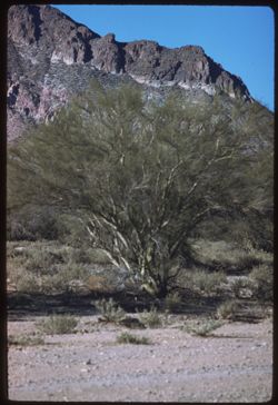
- Description:
- 100 f 5.6 tl
- Subject:
- Palo verde trees, Trees, Mountains, Shrubs, and Tucson Mountains (Ariz.)
- Series:
- 6-59
- Creator:
- Cushman, Charles W., 1896-1972
- Date Created:
- 1959-01-25
- Genre:
- Identification photographs
- Frame Number:
- 6
- County:
- Pima
- Abstract:
- A palo verde
- Call Number:
- P10544
- City:
- Tucson
- Country:
- United States
- State/Province:
- Arizona
- Alternate Identifier:
- 659.6
- Persistent URL:
- http://purl.dlib.indiana.edu/iudl/archives/cushman/P10544
-
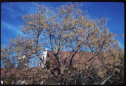
- Description:
- 100 f 8 tl
- Subject:
- Trees, Mountains, and Tucson Mountains (Ariz.)
- Series:
- 6-59
- Creator:
- Cushman, Charles W., 1896-1972
- Date Created:
- 1959-01-25
- Genre:
- Landscape photographs
- Frame Number:
- 5
- County:
- Pima
- Abstract:
- Maybe Golden Gate Mtn (?)
- Call Number:
- P10543
- City:
- Tucson
- Country:
- United States
- State/Province:
- Arizona
- Alternate Identifier:
- 659.5
- Persistent URL:
- http://purl.dlib.indiana.edu/iudl/archives/cushman/P10543
-
- Description:
- 100 f 8 tl
- Subject:
- Palo verde trees, Cactus, Trees, Mountains, Tucson Mountains (Ariz.), and Cat Mountain (Ariz.)
- Series:
- 6-59
- Creator:
- Cushman, Charles W., 1896-1972
- Date Created:
- 1959-01-25
- Genre:
- Landscape photographs
- Frame Number:
- 4
- County:
- Pima
- Abstract:
- Cat Mtn. with Palos Verdes
- Call Number:
- P10542
- City:
- Tucson
- Country:
- United States
- State/Province:
- Arizona
- Alternate Identifier:
- 659.4
- Persistent URL:
- http://purl.dlib.indiana.edu/iudl/archives/cushman/P10542
-
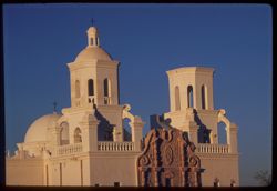
- Description:
- 100 f 8 tl
- Subject:
- Domes, Crosses, Mission churches, Arches, Windows, Stairways, Towers, and Mission San Xavier del Bac (Tucson, Ariz.)
- Series:
- 6-59
- Creator:
- Cushman, Charles W., 1896-1972
- Date Created:
- 1959-01-24
- Genre:
- Architectural photographs
- Frame Number:
- 3
- County:
- Pima
- Abstract:
- Both Towers
- Call Number:
- P10541
- City:
- Tucson
- Country:
- United States
- State/Province:
- Arizona
- Alternate Identifier:
- 659.3
- Persistent URL:
- http://purl.dlib.indiana.edu/iudl/archives/cushman/P10541
-

- Description:
- 100 f 8 tl
- Subject:
- Domes, Crosses, Mission churches, Arches, Shrubs, Masonry, Trees, Towers, Mission San Xavier del Bac (Tucson, Ariz.), and Stone walls
- Series:
- 6-59
- Creator:
- Cushman, Charles W., 1896-1972
- Date Created:
- 1959-01-24
- Genre:
- Architectural photographs
- Frame Number:
- 2
- County:
- Pima
- Abstract:
- West Tower of church
- Call Number:
- P10540
- City:
- Tucson
- Country:
- United States
- State/Province:
- Arizona
- Alternate Identifier:
- 659.2
- Persistent URL:
- http://purl.dlib.indiana.edu/iudl/archives/cushman/P10540
-
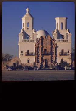
- Description:
- 100 f 8 tl
- Subject:
- Towers, Crosses, Cactus, Automobiles, Trees, Arches, Shrubs, Mission San Xavier del Bac (Tucson, Ariz.), Domes, Stone walls, Bell towers, and Mission churches
- Series:
- 6-59
- Creator:
- Cushman, Charles W., 1896-1972
- Date Created:
- 1959-01-24
- Genre:
- Architectural photographs
- Frame Number:
- 1
- County:
- Pima
- Abstract:
- San Xavier Mission church
- Call Number:
- P10539
- City:
- Tucson
- Country:
- United States
- State/Province:
- Arizona
- Alternate Identifier:
- 659.1
- Persistent URL:
- http://purl.dlib.indiana.edu/iudl/archives/cushman/P10539
-
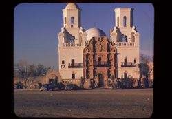
- Description:
- 100 f 8 tl
- Subject:
- Towers, Railings, Cactus, Automobiles, Trees, Arches, Masonry, Mission San Xavier del Bac (Tucson, Ariz.), Domes, Stone walls, Bell towers, Mission churches,...
- Series:
- 5-59
- Creator:
- Cushman, Charles W., 1896-1972
- Date Created:
- 1959-01-24
- Genre:
- Architectural photographs
- Frame Number:
- 37
- County:
- Pima
- Abstract:
- San Xavier
- Call Number:
- P10538
- City:
- Tucson
- Country:
- United States
- State/Province:
- Arizona
- Physical Description:
- masked.
- Alternate Identifier:
- 559.37
- Persistent URL:
- http://purl.dlib.indiana.edu/iudl/archives/cushman/P10538
-
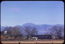
- Description:
- 100 f 6.3 tl
- Subject:
- Fences, Mountains, Trees, Dwellings, Horses, Electric lines, Shrubs, and Cochise Head (Ariz.)
- Series:
- 5-59
- Creator:
- Cushman, Charles W., 1896-1972
- Date Created:
- 1959-01-23
- Genre:
- Landscape photographs
- Frame Number:
- 36
- Street Address:
- Arizona State Highway 86
- County:
- Cochise
- Abstract:
- Cochise Head from Ariz Hwy 86
- Call Number:
- P10537
- Country:
- United States
- State/Province:
- Arizona
- Alternate Identifier:
- 559.36
- Persistent URL:
- http://purl.dlib.indiana.edu/iudl/archives/cushman/P10537
-
- Description:
- 25 f 12
- Subject:
- Rocks, Thorns, Cactus, Plomosa Mountains (Ariz.), Plants, and Cholla
- Series:
- 16-53
- Creator:
- Cushman, Charles W., 1896-1972
- Date Created:
- 1953-11-22
- Genre:
- Identification photographs
- Frame Number:
- 2
- Street Address:
- United States Highway 60 and United States Highway 70
- County:
- Yuma
- Abstract:
- Cholla changing color (same site)
- Call Number:
- P07074
- City:
- Quartzsite
- Country:
- United States
- State/Province:
- Arizona
- Alternate Identifier:
- 1653.2
- Persistent URL:
- http://purl.dlib.indiana.edu/iudl/archives/cushman/P07074
-
- Description:
- 50 f 9
- Subject:
- Rocks, Grasses, Trees, Mountains, Plomosa Mountains (Ariz.), and Hills
- Series:
- 16-53
- Creator:
- Cushman, Charles W., 1896-1972
- Date Created:
- 1953-11-22
- Genre:
- Landscape photographs
- Frame Number:
- 1
- Street Address:
- United States Highway 60 and United States Highway 70
- County:
- Yuma
- Abstract:
- Plomosa Mtns. Along US 60-70 near Quartzsite, Ariz.
- Call Number:
- P07073
- City:
- Quartzsite
- Country:
- United States
- State/Province:
- Arizona
- Alternate Identifier:
- 1653.1
- Persistent URL:
- http://purl.dlib.indiana.edu/iudl/archives/cushman/P07073
-
- Description:
- 50 f 9
- Subject:
- Hills, Cliffs, Mountains, Trees, Rocks, and Rock formations
- Series:
- 15-53
- Creator:
- Cushman, Charles W., 1896-1972
- Date Created:
- 1953-11-21
- Genre:
- Landscape photographs
- Frame Number:
- 39
- County:
- Coconino
- Abstract:
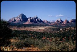
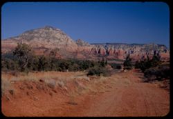
- Last look at rocks near Sedona
- Call Number:
- P07072
- City:
- Sedona
- Country:
- United States
- State/Province:
- Arizona
- Alternate Identifier:
- 1553.39
- Persistent URL:
- http://purl.dlib.indiana.edu/iudl/archives/cushman/P07072
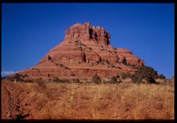
-
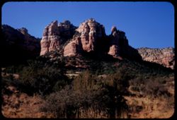
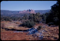
- Description:
- 50 f 8
- Subject:
- Cathedral Rock (Coconino County, Ariz.), Grasses, Cliffs, Trees, Mountains, Rock formations, and Hills
- Series:
- 15-53
- Creator:
- Cushman, Charles W., 1896-1972
- Date Created:
- 1953-11-21
- Genre:
- Landscape photographs
- Frame Number:
- 38
- County:
- Coconino
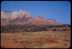
- Abstract:
- Cathedral peak across the road
- Call Number:
- P07071
- City:
- Sedona
- Country:
- United States
- State/Province:
- Arizona
- Alternate Identifier:
- 1553.38
- Persistent URL:
- http://purl.dlib.indiana.edu/iudl/archives/cushman/P07071
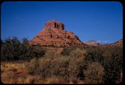
-
- Description:
- 50 f 9
- Subject:
- Rocks, Grasses, Cliffs, Dirt roads, Trees, Mountains, Rock formations, and Hills
- Series:
- 15-53
- Creator:
- Cushman, Charles W., 1896-1972
- Date Created:
- 1953-11-21
- Genre:
- Landscape photographs
- Frame Number:
- 37
- County:
- Coconino
- Abstract:
- Same from closer
- Call Number:
- P07070
- City:
- Sedona
- Country:
- United States
- State/Province:
- Arizona
- Physical Description:
- Image was originally mounted in a glass enclosure. Before digitization, the image was removed and placed in a Wess Plastic, Inc. brand, 2" x 2", pl...
- Alternate Identifier:
- 1553.37
- Persistent URL:
- http://purl.dlib.indiana.edu/iudl/archives/cushman/P07070
-
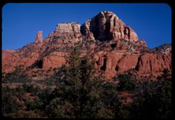
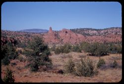
- Description:
- 50 f 11
- Subject:
- Grasses, Cliffs, Trees, Mountains, Rock formations, and Hills
- Series:
- 15-53
- Creator:
- Cushman, Charles W., 1896-1972
- Date Created:
- 1953-11-21
- Genre:
- Landscape photographs
- Frame Number:
- 36
- County:
- Coconino
- Abstract:
- Same rock 35 from south
- Call Number:
- P07069
- City:
- Sedona
- Country:
- United States
- State/Province:
- Arizona
- Alternate Identifier:
- 1553.36
- Persistent URL:
- http://purl.dlib.indiana.edu/iudl/archives/cushman/P07069
-
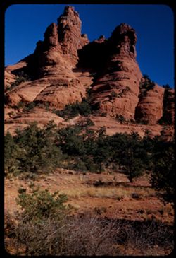
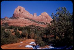
- Description:
- 50 f 9
- Subject:
- Grasses, Cliffs, Trees, Mountains, Rock formations, and Hills
- Series:
- 15-53
- Creator:
- Cushman, Charles W., 1896-1972
- Date Created:
- 1953-11-21
- Genre:
- Landscape photographs
- Frame Number:
- 35
- County:
- Coconino
- Abstract:
- Red double turret 6 mi. s of Sedona
- Call Number:
- P07068
- City:
- Sedona
- Country:
- United States
- State/Province:
- Arizona
- Alternate Identifier:
- 1553.35
- Persistent URL:
- http://purl.dlib.indiana.edu/iudl/archives/cushman/P07068
-
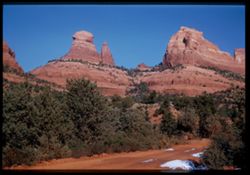
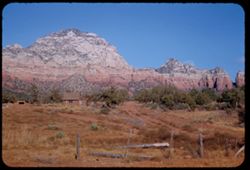
- Description:
- 50 f 9
- Subject:
- Cliffs, Trees, Tree limbs, Mountains, Rock formations, and Hills
- Series:
- 15-53
- Creator:
- Cushman, Charles W., 1896-1972
- Date Created:
- 1953-11-21
- Genre:
- Landscape photographs
- Frame Number:
- 34
- County:
- Coconino
- Abstract:
- From 3 miles south of Sedona
- Call Number:
- P07067
- City:
- Sedona
- Country:
- United States
- State/Province:
- Arizona
- Alternate Identifier:
- 1553.34
- Persistent URL:
- http://purl.dlib.indiana.edu/iudl/archives/cushman/P07067
-
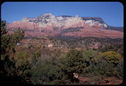
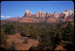
- Description:
- 50 f 9
- Subject:
- Valleys, Houses, Trees, Oak Creek (Ariz.), Rock formations, Hills, Mesas, and Mountains
- Series:
- 15-53
- Creator:
- Cushman, Charles W., 1896-1972
- Date Created:
- 1953-11-21
- Genre:
- Landscape photographs and Cityscape photographs
- Frame Number:
- 33
- County:
- Coconino
- Abstract:
- The great rock wall north of Sedona from across Oak Ck. Valley
- Call Number:
- P07066
- City:
- Sedona
- Country:
- United States
- State/Province:
- Arizona
- Alternate Identifier:
- 1553.33
- Persistent URL:
- http://purl.dlib.indiana.edu/iudl/archives/cushman/P07066
-
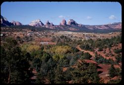
- Description:
- 50 f 8
- Subject:
- Valleys, Houses, Trees, Oak Creek (Ariz.), Rock formations, Hills, and Mountains
- Series:
- 15-53
- Creator:
- Cushman, Charles W., 1896-1972
- Date Created:
- 1953-11-21
- Genre:
- Landscape photographs and Cityscape photographs
- Frame Number:
- 32
- County:
- Coconino
- Abstract:
- NW across Oak Creek valley & Sedona
- Call Number:
- P07065
- City:
- Sedona
- Country:
- United States
- State/Province:
- Arizona
- Alternate Identifier:
- 1553.32
- Persistent URL:
- http://purl.dlib.indiana.edu/iudl/archives/cushman/P07065
-
- Description:
- 50 f 8
- Subject:
- Snow, Dirt roads, Trees, Mountains, Rock formations, Hills, and Oak Creek (Ariz.)
- Series:
- 15-53
- Creator:
- Cushman, Charles W., 1896-1972
- Date Created:
- 1953-11-21
- Genre:
- Landscape photographs
- Frame Number:
- 31
- County:
- Coconino
- Abstract:
- A little to the left
- Call Number:
- P07064
- City:
- Sedona
- Country:
- United States
- State/Province:
- Arizona
- Physical Description:
- Image was originally mounted in a glass enclosure. Before digitization, the image was removed and placed in a Wess Plastic, Inc. brand, 2" x 2", pl...
- Alternate Identifier:
- 1553.31
- Persistent URL:
- http://purl.dlib.indiana.edu/iudl/archives/cushman/P07064
-
- Description:
- 50 f 9
- Subject:
- Snow, Dirt roads, Trees, Mountains, Rock formations, Hills, and Oak Creek (Ariz.)
- Series:
- 15-53
- Creator:
- Cushman, Charles W., 1896-1972
- Date Created:
- 1953-11-21
- Genre:
- Landscape photographs
- Frame Number:
- 30
- County:
- Coconino
- Abstract:
- Crazy red rocks from below
- Call Number:
- P07063
- City:
- Sedona
- Country:
- United States
- State/Province:
- Arizona
- Alternate Identifier:
- 1553.30
- Persistent URL:
- http://purl.dlib.indiana.edu/iudl/archives/cushman/P07063
-
- Description:
- 50 f 9
- Subject:
- Cactus, Trees, Oak Creek (Ariz.), Rock formations, Hills, Mountains, and Shrubs
- Series:
- 15-53
- Creator:
- Cushman, Charles W., 1896-1972
- Date Created:
- 1953-11-21
- Genre:
- Landscape photographs and Cityscape photographs
- Frame Number:
- 29
- County:
- Coconino
- Abstract:
- From the east looking across Sedona to great rock forms beyond
- Call Number:
- P07062
- City:
- Sedona
- Country:
- United States
- State/Province:
- Arizona
- Alternate Identifier:
- 1553.29
- Persistent URL:
- http://purl.dlib.indiana.edu/iudl/archives/cushman/P07062
-
- Description:
- 50 f 9
- Subject:
- Grasses, Trees, Dirt, Mountains, Rock formations, and Hills
- Series:
- 15-53
- Creator:
- Cushman, Charles W., 1896-1972
- Date Created:
- 1953-11-21
- Genre:
- Landscape photographs
- Frame Number:
- 27
- County:
- Coconino
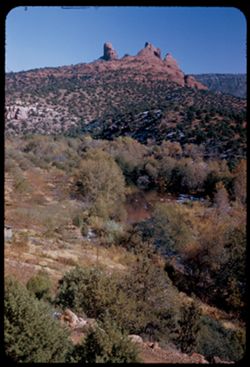
- Abstract:
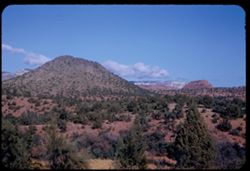
- And these, due north
- Call Number:
- P07060
- City:
- Sedona
- Country:
- United States
- State/Province:
- Arizona
- Alternate Identifier:
- 1553.27
- Persistent URL:
- http://purl.dlib.indiana.edu/iudl/archives/cushman/P07060
-
- Description:
- 50 f 8
- Subject:
- Rock formations, Rocks, Hills, Mountains, Grasses, Trees, Streams, Snow, and Oak Creek (Ariz.)
- Series:
- 15-53
- Creator:
- Cushman, Charles W., 1896-1972
- Date Created:
- 1953-11-21
- Genre:
- Landscape photographs
- Frame Number:
- 28
- County:
- Coconino
- Abstract:
- From Sedona, across Oak Creek toward crazy red rocks
- Call Number:
- P07061
- City:
- Sedona
- Country:
- United States
- State/Province:
- Arizona
- Alternate Identifier:
- 1553.28
- Persistent URL:
- http://purl.dlib.indiana.edu/iudl/archives/cushman/P07061
-
- Description:
- 50 f 11
- Subject:
- Meadows, Hills, Shrubs, Grasses, Fences, Clouds, and Rock formations
- Series:
- 15-53
- Creator:
- Cushman, Charles W., 1896-1972
- Date Created:
- 1953-11-21
- Genre:
- Landscape photographs
- Frame Number:
- 26
- County:
- Coconino
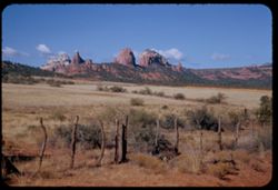
- Abstract:
- Rock forms NW from Sedona
- Call Number:
- P07059
- City:
- Sedona
- Country:
- United States
- State/Province:
- Arizona
- Alternate Identifier:
- 1553.26
- Persistent URL:
- http://purl.dlib.indiana.edu/iudl/archives/cushman/P07059
-
- Description:
- 50 f 11
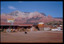
- Subject:
- American Automobile Association, Dogs, Advertisements, Hitching Post Motel (Sedona, Ariz.), Motels, Dirt, Mountains, Buildings, Railings, Signs (Notices), Ro...
- Series:
- 15-53
- Creator:
- Cushman, Charles W., 1896-1972
- Date Created:
- 1953-11-21
- Genre:
- Landscape photographs and Cityscape photographs
- Frame Number:
- 25
- County:
- Coconino
- Abstract:
- Sedona
- Call Number:
- P07058
- City:
- Sedona
- Country:
- United States
- State/Province:
- Arizona
- Physical Description:
- Image was originally mounted in a glass enclosure. Before digitization, the image was removed and placed in a Wess Plastic, Inc. brand, 2" x 2", pl...
- Alternate Identifier:
- 1553.25
- Persistent URL:
- http://purl.dlib.indiana.edu/iudl/archives/cushman/P07058
-
- Description:
- 50 f 9
- Subject:
- Grasses, Trees, Mountains, Rock formations, and Hills
- Series:
- 15-53
- Creator:
- Cushman, Charles W., 1896-1972
- Date Created:
- 1953-11-21
- Genre:
- Landscape photographs
- Frame Number:
- 21
- Street Address:
- United States Highway 89A
- County:
- Coconino
- Abstract:
- Red rock east of green hill
- Call Number:
- P07054
- City:
- Sedona
- Country:
- United States
- State/Province:
- Arizona
- Alternate Identifier:
- 1553.21
- Persistent URL:
- http://purl.dlib.indiana.edu/iudl/archives/cushman/P07054
-
- Description:
- 50 f 9
- Subject:
- Farmhouses, Farms, Trees, Log cabins, Mountains, Fences, Shrubs, Grasses, and Rock formations
- Series:
- 15-53
- Creator:
- Cushman, Charles W., 1896-1972
- Date Created:
- 1953-11-21
- Genre:
- Landscape photographs
- Frame Number:
- 23
- County:
- Coconino
- Abstract:
- Log cabin & high wall near Sedona
- Call Number:
- P07056
- City:
- Sedona
- Country:
- United States
- State/Province:
- Arizona
- Alternate Identifier:
- 1553.23
- Persistent URL:
- http://purl.dlib.indiana.edu/iudl/archives/cushman/P07056
-
- Description:
- 50 f 9
- Subject:
- Rocks, Grasses, Roads, Mesas, Mountains, Rock formations, Snow, Trees, and Oak Creek (Ariz.)
- Series:
- 15-53
- Creator:
- Cushman, Charles W., 1896-1972
- Date Created:
- 1953-11-21
- Genre:
- Landscape photographs
- Frame Number:
- 24
- County:
- Coconino
- Abstract:
- Fortress of red rock above Sedona
- Call Number:
- P07057
- City:
- Sedona
- Country:
- United States
- State/Province:
- Arizona
- Alternate Identifier:
- 1553.24
- Persistent URL:
- http://purl.dlib.indiana.edu/iudl/archives/cushman/P07057
-
- Description:
- 50 f 6.3 POLA
- Subject:
- Rocks, Grasses, Dirt roads, Trees, Mountains, Rock formations, Hills, and Mesas
- Series:
- 15-53
- Creator:
- Cushman, Charles W., 1896-1972
- Date Created:
- 1953-11-21
- Genre:
- Landscape photographs
- Frame Number:
- 22
- Street Address:
- United States Highway 89A
- County:
- Coconino
- Abstract:
- North from point on US 89A about 5 mi sw of Sedona
- Call Number:
- P07055
- City:
- Sedona
- Country:
- United States
- State/Province:
- Arizona
- Alternate Identifier:
- 1553.22
- Persistent URL:
- http://purl.dlib.indiana.edu/iudl/archives/cushman/P07055
-
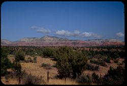
- Description:
- 50 f 9
- Subject:
- Grasses, Mesas, Mountains, Clouds, Hills, and Trees
- Series:
- 15-53
- Creator:
- Cushman, Charles W., 1896-1972
- Date Created:
- 1953-11-21
- Genre:
- Landscape photographs
- Frame Number:
- 20
- Street Address:
- United States Highway 89A
- County:
- Coconino
- Abstract:
- The green hill about 7 miles sw of Sedona
- Call Number:
- P07053
- City:
- Sedona
- Country:
- United States
- State/Province:
- Arizona
- Alternate Identifier:
- 1553.20
- Persistent URL:
- http://purl.dlib.indiana.edu/iudl/archives/cushman/P07053
-

- Description:
- 50 f 10
- Subject:
- Grasses, Trees, Mountains, Clouds, Hills, and Mesas
- Series:
- 15-53
- Creator:
- Cushman, Charles W., 1896-1972
- Date Created:
- 1953-11-21
- Genre:
- Landscape photographs
- Frame Number:
- 19
- Street Address:
- United States Highway 89A
- County:
- Coconino
- Abstract:
- The green hill about 7 miles sw of Sedona
- Call Number:
- P07052
- City:
- Sedona
- Country:
- United States
- State/Province:
- Arizona
- Alternate Identifier:
- 1553.19
- Persistent URL:
- http://purl.dlib.indiana.edu/iudl/archives/cushman/P07052
-
- Description:
- 50 f 6.3 POLA
- Subject:
- Grasses, Cliffs, Mesas, Mountains, Fences, Shrubs, Clouds, Hills, and Trees
- Series:
- 15-53
- Creator:
- Cushman, Charles W., 1896-1972
- Date Created:
- 1953-11-21
- Genre:
- Landscape photographs
- Frame Number:
- 18
- Street Address:
- United States Highway 89A
- County:
- Coconino
- Abstract:
- View North
- Call Number:
- P07051
- City:
- Sedona
- Country:
- United States
- State/Province:
- Arizona
- Alternate Identifier:
- 1553.18
- Persistent URL:
- http://purl.dlib.indiana.edu/iudl/archives/cushman/P07051
-
- Description:
- 50 f 6.3 POLA
- Subject:
- Grasses, Cliffs, Trees, Mountains, Shrubs, Hills, Mesas, and Rock formations
- Series:
- 15-53
- Creator:
- Cushman, Charles W., 1896-1972
- Date Created:
- 1953-11-21
- Genre:
- Landscape photographs
- Frame Number:
- 17
- Street Address:
- United States Highway 89A
- County:
- Coconino
- Abstract:
- View NE.
- Call Number:
- P07050
- City:
- Sedona
- Country:
- United States
- State/Province:
- Arizona
- Alternate Identifier:
- 1553.17
- Persistent URL:
- http://purl.dlib.indiana.edu/iudl/archives/cushman/P07050
-
- Description:
- 50 f 6.3
- Subject:
- Hills, Mountains, Shrubs, Snow, Mingus Mountain (Ariz.), Grasses, and Rocks
- Series:
- 15-53
- Creator:
- Cushman, Charles W., 1896-1972
- Date Created:
- 1953-11-21
- Genre:
- Landscape photographs and Cityscape photographs
- Frame Number:
- 15
- County:
- Yavapai
- Abstract:
- Looking back toward Jerome and Mingus Mtn from Clarkdale
- Call Number:
- P07049
- City:
- Clarkdale and Jerome
- Country:
- United States
- State/Province:
- Arizona
- Physical Description:
- Image was originally mounted in a glass enclosure. Before digitization, the image was removed and placed in a Wess Plastic, Inc. brand, 2" x 2", pl...
- Alternate Identifier:
- 1553.15
- Persistent URL:
- http://purl.dlib.indiana.edu/iudl/archives/cushman/P07049
-
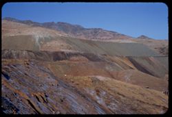
- Description:
- 50 f 11
- Subject:
- Terraces, Copper industry, Copper mining, Hills, and Phelps Dodge Corporation
- Series:
- 15-53
- Creator:
- Cushman, Charles W., 1896-1972
- Date Created:
- 1953-11-21
- Genre:
- Landscape photographs and Identification photographs
- Frame Number:
- 14
- County:
- Yavapai
- Abstract:
- Terraces west of town
- Call Number:
- P07048
- City:
- Jerome
- Country:
- United States
- State/Province:
- Arizona
- Alternate Identifier:
- 1553.14
- Persistent URL:
- http://purl.dlib.indiana.edu/iudl/archives/cushman/P07048
-
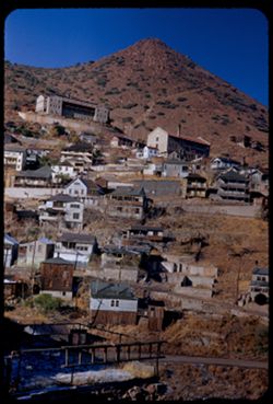
- Description:
- 50 f 8
- Subject:
- Houses, Automobiles, Copper industry, Shadows, Streets, Abandoned buildings, Buildings, Clotheslines, Laundry, Hills, Utility poles, and Ghost towns
- Series:
- 15-53
- Creator:
- Cushman, Charles W., 1896-1972
- Date Created:
- 1953-11-21
- Genre:
- Cityscape photographs
- Frame Number:
- 13
- County:
- Yavapai
- Abstract:
- View south from NE approach
- Call Number:
- P07047
- City:
- Jerome
- Country:
- United States
- State/Province:
- Arizona
- Alternate Identifier:
- 1553.13
- Persistent URL:
- http://purl.dlib.indiana.edu/iudl/archives/cushman/P07047
-
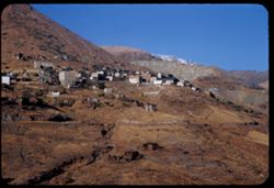
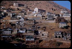
- Description:
- 50 f 10
- Subject:
- Grasses, Houses, Copper industry, Abandoned buildings, Mountains, Buildings, Hills, and Roads
- Series:
- 15-53
- Creator:
- Cushman, Charles W., 1896-1972
- Date Created:
- 1953-11-21
- Genre:
- Cityscape photographs
- Frame Number:
- 12
- County:
- Yavapai
- Abstract:
- View from NE approach
- Call Number:
- P07046
- City:
- Jerome
- Country:
- United States
- State/Province:
- Arizona
- Alternate Identifier:
- 1553.12
- Persistent URL:
- http://purl.dlib.indiana.edu/iudl/archives/cushman/P07046
-
- Description:
- 50 f 9
- Subject:
- Grasses, Houses, Copper industry, Streets, Abandoned buildings, Buildings, Hills, and Ghost towns
- Series:
- 15-53
- Creator:
- Cushman, Charles W., 1896-1972
- Date Created:
- 1953-11-21
- Genre:
- Cityscape photographs
- Frame Number:
- 11
- County:
- Yavapai
- Abstract:
- View from east
- Call Number:
- P07045
- City:
- Jerome
- Country:
- United States
- State/Province:
- Arizona
- Alternate Identifier:
- 1553.11
- Persistent URL:
- http://purl.dlib.indiana.edu/iudl/archives/cushman/P07045
-
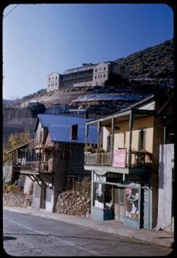
- Description:
- 50 f 6.3
- Subject:
- Advertisements, Streets, Hills, Business districts, Copper industry, Window boxes, Shrubs, Buildings, Coca-Cola Company, Storefronts, Stone walls, Balconies,...
- Series:
- 15-53
- Creator:
- Cushman, Charles W., 1896-1972
- Date Created:
- 1953-11-21
- Genre:
- Cityscape photographs
- Frame Number:
- 9
- County:
- Yavapai
- Abstract:
- from other direction - looking south & up
- Call Number:
- P07043
- City:
- Jerome
- Country:
- United States
- State/Province:
- Arizona
- Alternate Identifier:
- 1553.9
- Persistent URL:
- http://purl.dlib.indiana.edu/iudl/archives/cushman/P07043
-
- Description:
- 50 f 9
- Subject:
- Abandoned buildings, Streets, Ghost towns, Houses, Copper industry, Utility poles, Buildings, Grasses, and Hills
- Series:
- 15-53
- Creator:
- Cushman, Charles W., 1896-1972
- Date Created:
- 1953-11-21
- Genre:
- Cityscape photographs
- Frame Number:
- 10
- County:
- Yavapai
- Abstract:
- View from east
- Call Number:
- P07044
- City:
- Jerome
- Country:
- United States
- State/Province:
- Arizona
- Alternate Identifier:
- 1553.10
- Persistent URL:
- http://purl.dlib.indiana.edu/iudl/archives/cushman/P07044
-
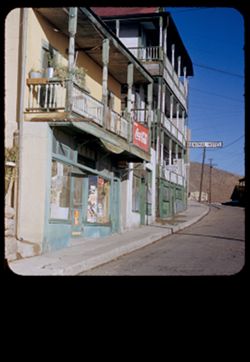
- Description:
- 50 f 8
- Subject:
- Central Hotel (Jerome, Ariz.), Balconies, Copper industry, Signs (Notices), Streets, Buildings, Hotels, Business districts, Utility poles, Coca-Cola Company,...
- Series:
- 15-53
- Creator:
- Cushman, Charles W., 1896-1972
- Date Created:
- 1953-11-21
- Genre:
- Cityscape photographs
- Frame Number:
- 8
- County:
- Yavapai
- Abstract:
- Winding street (business)
- Call Number:
- P07042
- City:
- Jerome
- Country:
- United States
- State/Province:
- Arizona
- Physical Description:
- masked.
- Alternate Identifier:
- 1553.8
- Persistent URL:
- http://purl.dlib.indiana.edu/iudl/archives/cushman/P07042
-
- Description:
- 50 f 2
- Subject:
- Cliffs, Mountains, Snow, Trees, Mingus Mountain (Ariz.), Grasses, and Rocks
- Series:
- 15-53
- Creator:
- Cushman, Charles W., 1896-1972
- Date Created:
- 1953-11-20
- Genre:
- Landscape photographs
- Frame Number:
- 7
- Street Address:
- United States Highway 89A
- County:
- Yavapai
- Abstract:
- From same curve as 6
- Call Number:
- P07041
- City:
- Prescott and Jerome
- Country:
- United States
- State/Province:
- Arizona
- Alternate Identifier:
- 1553.7
- Persistent URL:
- http://purl.dlib.indiana.edu/iudl/archives/cushman/P07041
-
- Description:
- 50 f 2.8
- Subject:
- Snow, Grasses, Roads, Mingus Mountain (Ariz.), Mountains, Rocks, and Trees
- Series:
- 15-53
- Creator:
- Cushman, Charles W., 1896-1972
- Date Created:
- 1953-11-20
- Genre:
- Landscape photographs
- Frame Number:
- 6
- Street Address:
- United States Highway 89A
- County:
- Yavapai
- Abstract:
- S curve
- Call Number:
- P07040
- City:
- Jerome and Prescott
- Country:
- United States
- State/Province:
- Arizona
- Alternate Identifier:
- 1553.6
- Persistent URL:
- http://purl.dlib.indiana.edu/iudl/archives/cushman/P07040
-
- Description:
- 50 f 2.8
- Subject:
- Traffic signs & signals, Roads, Mountains, Snow, Trees, Rocks, Railings, Grasses, and Mingus Mountain (Ariz.)
- Series:
- 15-53
- Creator:
- Cushman, Charles W., 1896-1972
- Date Created:
- 1953-11-20
- Genre:
- Landscape photographs
- Frame Number:
- 5
- Street Address:
- United States Highway 89A
- County:
- Yavapai
- Abstract:
- US 89A through Mingus Mtns.
- Call Number:
- P07039
- Country:
- United States
- State/Province:
- Arizona
- Alternate Identifier:
- 1553.5
- Persistent URL:
- http://purl.dlib.indiana.edu/iudl/archives/cushman/P07039
-
- Description:
- 50 f 4
- Subject:
- Snow, Trees, Mountains, and Mingus Mountain (Ariz.)
- Series:
- 15-53
- Creator:
- Cushman, Charles W., 1896-1972
- Date Created:
- 1953-11-20
- Genre:
- Landscape photographs
- Frame Number:
- 4
- Street Address:
- United States Highway 89A
- County:
- Yavapai
- Abstract:
- Snow in Mingus Mtns
- Call Number:
- P07038
- City:
- Prescott
- Country:
- United States
- State/Province:
- Arizona
- Alternate Identifier:
- 1553.4
- Persistent URL:
- http://purl.dlib.indiana.edu/iudl/archives/cushman/P07038
-
- Description:
- 50 f 6.3
- Subject:
- Snow, Roads, Trees, Mountains, and Cliffs
- Series:
- 15-53
- Creator:
- Cushman, Charles W., 1896-1972
- Date Created:
- 1953-11-20
- Genre:
- Landscape photographs
- Frame Number:
- 3
- County:
- Yavapai
- Abstract:
- Snow covered cliffs along US 89 about 7 miles sw of Prescott
- Call Number:
- P07037
- City:
- Prescott
- Country:
- United States
- State/Province:
- Arizona
- Alternate Identifier:
- 1553.3
- Persistent URL:
- http://purl.dlib.indiana.edu/iudl/archives/cushman/P07037
-
- Description:
- 50 f 4.5
- Subject:
- Snow, Mountains, Hills, and Plants
- Series:
- 15-53
- Creator:
- Cushman, Charles W., 1896-1972
- Date Created:
- 1953-11-20
- Genre:
- Landscape photographs
- Frame Number:
- 2
- Street Address:
- United States Highway 89
- County:
- Yavapai
- Abstract:
- Snow on north side of mountain ridges - 12 miles sw of Prescott
- Call Number:
- P07036
- City:
- Prescott
- Country:
- United States
- State/Province:
- Arizona
- Alternate Identifier:
- 1553.2
- Persistent URL:
- http://purl.dlib.indiana.edu/iudl/archives/cushman/P07036
-
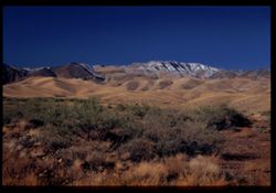
- Description:
- 50 f 4.5 POLA
- Subject:
- Valleys, Mountains, Clouds, Weaver Mountains (Ariz.), and Vulture Mountains (Ariz.)
- Series:
- 15-53
- Creator:
- Cushman, Charles W., 1896-1972
- Date Created:
- 1953-11-20
- Genre:
- Landscape photographs
- Frame Number:
- 1
- County:
- Maricopa
- Abstract:
- From Weaver Mtns. - view south across valley toward Wickenburg, Vulture Mtns., etc.
- Call Number:
- P07035
- City:
- Wickenberg
- Country:
- United States
- State/Province:
- Arizona
- Alternate Identifier:
- 1553.1
- Persistent URL:
- http://purl.dlib.indiana.edu/iudl/archives/cushman/P07035
-
- Description:
- 50 f 9
- Subject:
- Valleys, Mountains, Hills, and Weaver Mountains (Ariz.)
- Series:
- 14-53
- Creator:
- Cushman, Charles W., 1896-1972
- Date Created:
- 1953-11-20
- Genre:
- Landscape photographs
- Frame Number:
- 38
- Street Address:
- United States Highway 89
- County:
- Yavapai and Maricopa
- Abstract:
- Views of valley west of Weaver Mtns. From US 89 - 23 mi. from Wickenburg
- Call Number:
- P07034
- City:
- Wickenberg
- Country:
- United States
- State/Province:
- Arizona
- Physical Description:
- masked.
- Alternate Identifier:
- 1453.38
- Persistent URL:
- http://purl.dlib.indiana.edu/iudl/archives/cushman/P07034
-
- Description:
- 50 f 9
- Subject:
- Grasses, Rock mass, Mountains, Rock formations, Hills, and Shrubs
- Series:
- 14-53
- Creator:
- Cushman, Charles W., 1896-1972
- Date Created:
- 1953-11-19
- Genre:
- Landscape photographs
- Frame Number:
- 37
- Street Address:
- United States Highway 60 and United States Highway 70
- County:
- Pinal
- Abstract:
- Rock mass west of Superior
- Call Number:
- P07033
- City:
- Superior
- Country:
- United States
- State/Province:
- Arizona
- Alternate Identifier:
- 1453.37
- Persistent URL:
- http://purl.dlib.indiana.edu/iudl/archives/cushman/P07033
-
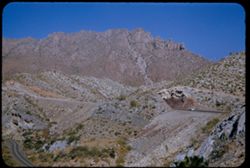
- Description:
- 50 f 11
- Subject:
- Rocks, Grasses, Queen Creek (Ariz.), Mountains, Rock formations, Plants, and Up-thrust peak
- Series:
- 14-53
- Creator:
- Cushman, Charles W., 1896-1972
- Date Created:
- 1953-11-19
- Genre:
- Landscape photographs and Identification photographs
- Frame Number:
- 36
- Street Address:
- United States Highway 60 and United States Highway 70
- County:
- Pinal
- Abstract:
- Up-thrust peak from same spot
- Call Number:
- P07032
- City:
- Superior
- Country:
- United States
- State/Province:
- Arizona
- Alternate Identifier:
- 1453.36
- Persistent URL:
- http://purl.dlib.indiana.edu/iudl/archives/cushman/P07032
-
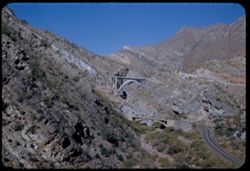
- Description:
- 50 f 11
- Subject:
- Queen Creek (Ariz.), Valleys, Roads, Queen Creek Bridge (Ariz.), Bridges, Mountains, Rocks, Streams, and Grasses
- Series:
- 14-53
- Creator:
- Cushman, Charles W., 1896-1972
- Date Created:
- 1953-11-19
- Genre:
- Landscape photographs
- Frame Number:
- 34
- Street Address:
- United States Highway 70 and United States Highway 60
- County:
- Pinal
- Abstract:
- Two bridges over Queen Creek near Superior
- Call Number:
- P07030
- City:
- Superior
- Country:
- United States
- State/Province:
- Arizona
- Alternate Identifier:
- 1453.34
- Persistent URL:
- http://purl.dlib.indiana.edu/iudl/archives/cushman/P07030
-
- Description:
- 50 f 11
- Subject:
- Rocks, Railings, Valleys, Grasses, Roads, Automobiles, Queen Creek (Ariz.), Mountains, and Rock formations
- Series:
- 14-53
- Creator:
- Cushman, Charles W., 1896-1972
- Date Created:
- 1953-11-19
- Genre:
- Landscape photographs
- Frame Number:
- 35
- Street Address:
- United States Highway 60 and United States Highway 70
- County:
- Pinal
- Abstract:
- Great rock face seen from same spot.
- Call Number:
- P07031
- City:
- Superior
- Country:
- United States
- State/Province:
- Arizona
- Alternate Identifier:
- 1453.35
- Persistent URL:
- http://purl.dlib.indiana.edu/iudl/archives/cushman/P07031
-
- Description:
- 50 f 11
- Subject:
- Rocks, Grasses, Roads, Trees, Queen Creek Bridge (Ariz.), Mountains, and Queen Creek (Ariz.)
- Series:
- 14-53
- Creator:
- Cushman, Charles W., 1896-1972
- Date Created:
- 1953-11-19
- Genre:
- Landscape photographs
- Frame Number:
- 33
- Street Address:
- United States Highway 60 and United States Highway 70
- County:
- Pinal
- Abstract:
- Two views from Queen Ck. Bridge
- Call Number:
- P07029
- City:
- Superior
- Country:
- United States
- State/Province:
- Arizona
- Alternate Identifier:
- 1453.33
- Persistent URL:
- http://purl.dlib.indiana.edu/iudl/archives/cushman/P07029