
Search Constraints
You searched for:
Campus
IUB
Remove constraint Campus: IUB
Pages
0-99 pages
Remove constraint Pages: 0-99 pages
State/Province
California
Remove constraint State/Province: California
Search Results
-
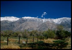
- Description:
- 25 f 8 Pola
- Subject:
- Snow, Grasses, Barbed wire, Trees, Mountains, Fences, Shrubs, and Inyo Mountains (Calif.)
- Series:
- 14-52
- Creator:
- Cushman, Charles W., 1896-1972
- Date Created:
- 1952-04-08
- Genre:
- Landscape photographs
- Frame Number:
- 38
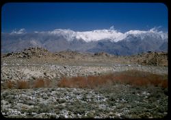
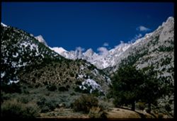
- County:
- Inyo
- Abstract:
- Inyo Mtns from Lone Pine.
- Call Number:
- P06021
- City:
- Lone Pine
- Country:
- United States
- State/Province:
- California
- Physical Description:
- Image was originally mounted in a glass enclosure. Before digitization, the image was removed and placed in a Wess Plastic, Inc. brand, 2" x 2", pl...
- Alternate Identifier:
- 1452.38
- Persistent URL:
- http://purl.dlib.indiana.edu/iudl/archives/cushman/P06021
- Holding Location:
- Bloomington - University Archives
Wells Library E460
1320 E 10th St.
Bloomington, IN 47405
Contact at archives@indiana.edu, 812-855-1127
-
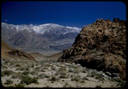
- Description:
- 25 f 8 Pola
- Subject:
- Snow, Valleys, Inyo Mountains (Calif.), Boulders, Owens Valley (Calif.), Mountains, Shrubs, Hills, Rocks, Alabama Hills (Calif.), and Rock formations
- Series:
- 14-52
- Creator:
- Cushman, Charles W., 1896-1972
- Date Created:
- 1952-04-08
- Genre:
- Landscape photographs
- Frame Number:
- 36
- Street Address:
- Mount Whitney Road
- County:
- Inyo
- Abstract:
- View across valley weird rock at it.
- Call Number:
- P06019
- Country:
- United States
- State/Province:
- California
- Alternate Identifier:
- 1452.36
- Persistent URL:
- http://purl.dlib.indiana.edu/iudl/archives/cushman/P06019
- Holding Location:
- Bloomington - University Archives
Wells Library E460
1320 E 10th St.
Bloomington, IN 47405
Contact at archives@indiana.edu, 812-855-1127
-
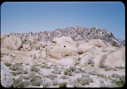
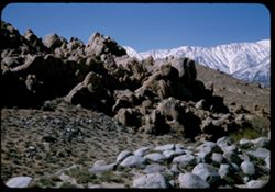
- Description:
- 25 f 11
- Subject:
- Rocks, Boulders, Alabama Hills (Calif.), Hills, Shrubs, and Rock formations
- Series:
- 14-52
- Creator:
- Cushman, Charles W., 1896-1972
- Date Created:
- 1952-04-08
- Genre:
- Landscape photographs
- Frame Number:
- 35
- County:
- Inyo
- Abstract:
- Gorilla + shark.
- Call Number:
- P06018
- City:
- Lone Pine
- Country:
- United States
- State/Province:
- California
- Alternate Identifier:
- 1452.35
- Persistent URL:
- http://purl.dlib.indiana.edu/iudl/archives/cushman/P06018
- Holding Location:
- Bloomington - University Archives
Wells Library E460
1320 E 10th St.
Bloomington, IN 47405
Contact at archives@indiana.edu, 812-855-1127
-

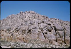
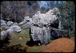
- Description:
- 25 f 11
- Subject:
- Hills, Mountains, Shrubs, Boulders, Rocks, Rock formations, and Crazy rocks
- Series:
- 14-52
- Creator:
- Cushman, Charles W., 1896-1972
- Date Created:
- 1952-04-08
- Genre:
- Landscape photographs
- Frame Number:
- 33
- Street Address:
- Mount Whitney Road
- County:
- Inyo
- Abstract:
- Crazy rocks along lower Mt. Whitney rd.
- Call Number:
- P06016
- City:
- Lone Pine
- Country:
- United States
- State/Province:
- California
- Alternate Identifier:
- 1452.33
- Persistent URL:
- http://purl.dlib.indiana.edu/iudl/archives/cushman/P06016
- Holding Location:
- Bloomington - University Archives
Wells Library E460
1320 E 10th St.
Bloomington, IN 47405
Contact at archives@indiana.edu, 812-855-1127
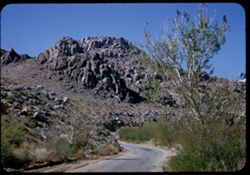
-
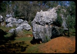
- Description:
- 25 f 11
- Subject:
- Hills, Shrubs, Boulders, Alabama Hills (Calif.), Rock formations, and Rocks
- Series:
- 14-52
- Creator:
- Cushman, Charles W., 1896-1972
- Date Created:
- 1952-04-08
- Genre:
- Snapshots
- Frame Number:
- 34
- County:
- Inyo
- Abstract:
- Same from dif. angle.
- Call Number:
- P06017
- City:
- Lone Pine
- Country:
- United States
- State/Province:
- California
- Alternate Identifier:
- 1452.34
- Persistent URL:
- http://purl.dlib.indiana.edu/iudl/archives/cushman/P06017
- Holding Location:
- Bloomington - University Archives
Wells Library E460
1320 E 10th St.
Bloomington, IN 47405
Contact at archives@indiana.edu, 812-855-1127
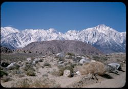
-
- Description:
- 25 f 8 Pola
- Subject:
- Rocks, Inyo Mountains (Calif.), Boulders, Owens Valley (Calif.), Mountains, Shrubs, Hills, and Snow
- Series:
- 14-52
- Creator:
- Cushman, Charles W., 1896-1972
- Date Created:
- 1952-04-08
- Genre:
- Landscape photographs
- Frame Number:
- 32
- Street Address:
- Mount Whitney Road
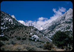
- County:
- Inyo
- Abstract:
- Across Owens Valley to Inyo Mtns.
- Call Number:
- P06015
- City:
- Lone Pine
- Country:
- United States
- State/Province:
- California
- Alternate Identifier:
- 1452.32
- Persistent URL:
- http://purl.dlib.indiana.edu/iudl/archives/cushman/P06015
- Holding Location:
- Bloomington - University Archives
Wells Library E460
1320 E 10th St.
Bloomington, IN 47405
Contact at archives@indiana.edu, 812-855-1127
-
- Description:
- 25 f 8 Pola
- Subject:
- Rocks, Valleys, Inyo Mountains (Calif.), Trees, Boulders, Owens Valley (Calif.), Mountains, Shrubs, Hills, and Snow
- Series:
- 14-52
- Creator:
- Cushman, Charles W., 1896-1972
- Date Created:
- 1952-04-08
- Genre:
- Landscape photographs
- Frame Number:
- 31
- Street Address:
- Mount Whitney Road
- County:
- Inyo
- Abstract:
- Owens Valley from Mt. Whitney Rd.
- Call Number:
- P06014
- Country:
- United States
- State/Province:
- California
- Physical Description:
- Image was originally mounted in a glass enclosure. Before digitization, the image was removed and placed in a Wess Plastic, Inc. brand, 2" x 2", pl...
- Alternate Identifier:
- 1452.31
- Persistent URL:
- http://purl.dlib.indiana.edu/iudl/archives/cushman/P06014
- Holding Location:
- Bloomington - University Archives
Wells Library E460
1320 E 10th St.
Bloomington, IN 47405
Contact at archives@indiana.edu, 812-855-1127
-
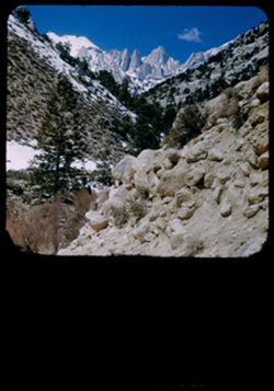
- Description:
- 25 f 9 Pola
- Subject:
- Whitney, Mount (Calif.), Mountains, Shrubs, Snow, Trees, Rocks, Portal station, Rock formations, and Boulders
- Series:
- 14-52
- Creator:
- Cushman, Charles W., 1896-1972
- Date Created:
- 1952-04-08
- Genre:
- Landscape photographs
- Frame Number:
- 29
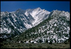
- County:
- Inyo
- Abstract:
- Whitney from Portal Station.
- Call Number:
- P06013
- Country:
- United States
- State/Province:
- California
- Physical Description:
- masked.
- Alternate Identifier:
- 1452.29
- Persistent URL:
- http://purl.dlib.indiana.edu/iudl/archives/cushman/P06013
- Holding Location:
- Bloomington - University Archives
Wells Library E460
1320 E 10th St.
Bloomington, IN 47405
Contact at archives@indiana.edu, 812-855-1127
-
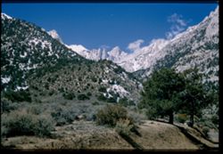
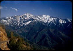
- Description:
- 25 f 13
- Subject:
- Snow, Roads, Trees, Mountains, Rock formations, Whitney, Mount (Calif.), Sierra Nevada (Calif. and Nev.), Shrubs, and Clouds
- Series:
- 14-52
- Creator:
- Cushman, Charles W., 1896-1972
- Date Created:
- 1952-04-08
- Genre:
- Landscape photographs
- Frame Number:
- 28
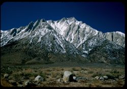
- County:
- Inyo
- Abstract:
- Mt. Whitney + spires.
- Call Number:
- P06012
- Country:
- United States
- State/Province:
- California
- Physical Description:
- Image was originally mounted in a glass enclosure. Before digitization, the image was removed and placed in a Wess Plastic, Inc. brand, 2" x 2", pl...
- Alternate Identifier:
- 1452.28
- Persistent URL:
- http://purl.dlib.indiana.edu/iudl/archives/cushman/P06012
- Holding Location:
- Bloomington - University Archives
Wells Library E460
1320 E 10th St.
Bloomington, IN 47405
Contact at archives@indiana.edu, 812-855-1127
-
- Description:
- 25 f 9 Pola
- Subject:
- Snow, Trees, Mountains, Shrubs, Whitney, Mount (Calif.), Sierra Nevada (Calif. and Nev.), Rock formations, and Clouds
- Series:
- 14-52
- Creator:
- Cushman, Charles W., 1896-1972
- Date Created:
- 1952-04-08
- Genre:
- Landscape photographs
- Frame Number:
- 27
- Street Address:
- Lone Pine-Whitney Road
- County:
- Placer and Inyo
- Abstract:
- Mt. Whitney + spires.
- Call Number:
- P06011
- City:
- Lone Pine
- Country:
- United States
- State/Province:
- California
- Physical Description:
- Image was originally mounted in a glass enclosure. Before digitization, the image was removed and placed in a Wess Plastic, Inc. brand, 2" x 2", pl...
- Alternate Identifier:
- 1452.27
- Persistent URL:
- http://purl.dlib.indiana.edu/iudl/archives/cushman/P06011
- Holding Location:
- Bloomington - University Archives
Wells Library E460
1320 E 10th St.
Bloomington, IN 47405
Contact at archives@indiana.edu, 812-855-1127
-
- Description:
- 25 f 6.3 Pola
- Subject:
- Snow, Trees, Mountains, Shrubs, Whitney, Mount (Calif.), Sierra Nevada (Calif. and Nev.), and Langley, Mount (Calif.)
- Series:
- 14-52
- Creator:
- Cushman, Charles W., 1896-1972
- Date Created:
- 1952-04-08
- Genre:
- Landscape photographs
- Frame Number:
- 26
- County:
- Inyo
- Abstract:
- Whitney's SE neighbor again. Mt. Langley, 14,042.
- Call Number:
- P06010
- City:
- Lone Pine
- Country:
- United States
- State/Province:
- California
- Physical Description:
- Image was originally mounted in a glass enclosure. Before digitization, the image was removed and placed in a Wess Plastic, Inc. brand, 2" x 2", pl...
- Alternate Identifier:
- 1452.26
- Persistent URL:
- http://purl.dlib.indiana.edu/iudl/archives/cushman/P06010
- Holding Location:
- Bloomington - University Archives
Wells Library E460
1320 E 10th St.
Bloomington, IN 47405
Contact at archives@indiana.edu, 812-855-1127
-
- Description:
- 25 f 13
- Subject:
- Snow, Trees, Mountains, Shrubs, Whitney, Mount (Calif.), Sierra Nevada (Calif. and Nev.), and Clouds
- Series:
- 14-52
- Creator:
- Cushman, Charles W., 1896-1972
- Date Created:
- 1952-04-08
- Genre:
- Landscape photographs
- Frame Number:
- 25
- County:
- Inyo
- Abstract:
- Whitney's peak.
- Call Number:
- P06009
- Country:
- United States
- State/Province:
- California
- Alternate Identifier:
- 1452.25
- Persistent URL:
- http://purl.dlib.indiana.edu/iudl/archives/cushman/P06009
- Holding Location:
- Bloomington - University Archives
Wells Library E460
1320 E 10th St.
Bloomington, IN 47405
Contact at archives@indiana.edu, 812-855-1127
-
- Description:
- 25 f 9 Pola
- Subject:
- Rocks, Lone Pine Peak (Calif.), Mountains, Shrubs, Sierra Nevada (Calif. and Nev.), Langley, Mount (Calif.), Snow, and Boulders
- Series:
- 14-52
- Creator:
- Cushman, Charles W., 1896-1972
- Date Created:
- 1952-04-08
- Genre:
- Landscape photographs
- Frame Number:
- 24
- County:
- Inyo
- Abstract:
- Same high peak - Langley, 14,042.
- Call Number:
- P06008
- Country:
- United States
- State/Province:
- California
- Alternate Identifier:
- 1452.24
- Persistent URL:
- http://purl.dlib.indiana.edu/iudl/archives/cushman/P06008
- Holding Location:
- Bloomington - University Archives
Wells Library E460
1320 E 10th St.
Bloomington, IN 47405
Contact at archives@indiana.edu, 812-855-1127
-
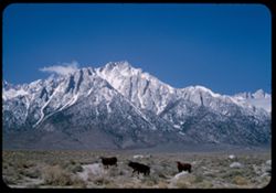
- Description:
- 50 f 10
- Subject:
- Lone Pine Peak (Calif.), Cows, Langley, Mount (Calif.), Whitney, Mount (Calif.), Mountains, Shrubs, Snow, Rocks, Farms, and Sierra Nevada (Calif. and Nev.)
- Series:
- 14-52
- Creator:
- Cushman, Charles W., 1896-1972
- Date Created:
- 1953-04-08
- Genre:
- Landscape photographs
- Frame Number:
- 23
- County:
- Inyo
- Abstract:
- 3 cows + high peak. SE of Whitney. Langley, 14,042.
- Call Number:
- P06007
- City:
- Lone Pine
- Country:
- United States
- State/Province:
- California
- Alternate Identifier:
- 1452.23
- Persistent URL:
- http://purl.dlib.indiana.edu/iudl/archives/cushman/P06007
- Holding Location:
- Bloomington - University Archives
Wells Library E460
1320 E 10th St.
Bloomington, IN 47405
Contact at archives@indiana.edu, 812-855-1127
-
- Description:
- 50 f 10
- Subject:
- Snow, Boulders, Mountains, Shrubs, Whitney, Mount (Calif.), Sierra Nevada (Calif. and Nev.), and Hills
- Series:
- 14-52
- Creator:
- Cushman, Charles W., 1896-1972
- Date Created:
- 1952-04-08
- Genre:
- Landscape photographs
- Frame Number:
- 22
- Street Address:
- Mount Whitney Road
- County:
- Inyo
- Abstract:
- And those to north.
- Call Number:
- P06006
- City:
- Lone Pine
- Country:
- United States
- State/Province:
- California
- Alternate Identifier:
- 1452.22
- Persistent URL:
- http://purl.dlib.indiana.edu/iudl/archives/cushman/P06006
- Holding Location:
- Bloomington - University Archives
Wells Library E460
1320 E 10th St.
Bloomington, IN 47405
Contact at archives@indiana.edu, 812-855-1127
-
- Description:
- 50 f 9
- Subject:
- Hills, Roads, Whitney, Mount (Calif.), Mountains, Shrubs, Sierra Nevada (Calif. and Nev.), Boulders, Rocks, Rock formations, and Snow
- Series:
- 14-52
- Creator:
- Cushman, Charles W., 1896-1972
- Date Created:
- 1952-04-08
- Genre:
- Landscape photographs
- Frame Number:
- 21
- County:
- Inyo
- Abstract:
- Whitney's neighbors to the South.
- Call Number:
- P06005
- Country:
- United States
- State/Province:
- California
- Alternate Identifier:
- 1452.21
- Persistent URL:
- http://purl.dlib.indiana.edu/iudl/archives/cushman/P06005
- Holding Location:
- Bloomington - University Archives
Wells Library E460
1320 E 10th St.
Bloomington, IN 47405
Contact at archives@indiana.edu, 812-855-1127
-
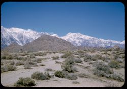
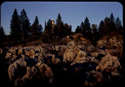
- Description:
- 50 f 9
- Subject:
- Hills, Mountains, Shrubs, Sierra Nevada (Calif. and Nev.), Boulders, Rocks, Rock formations, Snow, and Alabama Hills (Calif.)
- Series:
- 14-52
- Creator:
- Cushman, Charles W., 1896-1972
- Date Created:
- 1952-04-08
- Genre:
- Landscape photographs
- Frame Number:
- 20
- County:
- Inyo
- Abstract:
- Big bad rocks of Alabama hills.
- Call Number:
- P06004
- City:
- Lone Pine
- Country:
- United States
- State/Province:
- California
- Alternate Identifier:
- 1452.20
- Persistent URL:
- http://purl.dlib.indiana.edu/iudl/archives/cushman/P06004
- Holding Location:
- Bloomington - University Archives
Wells Library E460
1320 E 10th St.
Bloomington, IN 47405
Contact at archives@indiana.edu, 812-855-1127
-
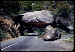
- Description:
- 50 f 8
- Subject:
- Rocks, Roads, Trees, Boulders, Alabama Hills (Calif.), Whitney, Mount (Calif.), Hills, Shrubs, and Rock formations
- Series:
- 14-52
- Creator:
- Cushman, Charles W., 1896-1972
- Date Created:
- 1952-04-08
- Genre:
- Landscape photographs
- Frame Number:
- 19
- Street Address:
- Mount Whitney Road
- County:
- Inyo
- Abstract:
- One of the Alabama Hills on Mt. Whitney Rd.
- Call Number:
- P06003
- City:
- Lone Pine
- Country:
- United States
- State/Province:
- California
- Alternate Identifier:
- 1452.19
- Persistent URL:
- http://purl.dlib.indiana.edu/iudl/archives/cushman/P06003
- Holding Location:
- Bloomington - University Archives
Wells Library E460
1320 E 10th St.
Bloomington, IN 47405
Contact at archives@indiana.edu, 812-855-1127
-

- Description:
- 50 f 9
- Subject:
- Hills, Roads, Whitney, Mount (Calif.), Mountains, Shrubs, Sierra Nevada (Calif. and Nev.), Trees, Rocks, Fences, Snow, Boulders, and Buildings
- Series:
- 14-52
- Creator:
- Cushman, Charles W., 1896-1972
- Date Created:
- 1952-04-08
- Genre:
- Landscape photographs
- Frame Number:
- 18
- County:
- Inyo
- Abstract:
- Mt. Whitney at dead center.
- Call Number:
- P06002
- Country:
- United States
- State/Province:
- California
- Alternate Identifier:
- 1452.18
- Persistent URL:
- http://purl.dlib.indiana.edu/iudl/archives/cushman/P06002
- Holding Location:
- Bloomington - University Archives
Wells Library E460
1320 E 10th St.
Bloomington, IN 47405
Contact at archives@indiana.edu, 812-855-1127
-
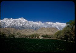
- Description:
- 25 f 8 Pola
- Subject:
- Croplands, Hills, Whitney, Mount (Calif.), Mountains, Shrubs, Snow, Trees, Farms, Clouds, Agricultural facilities, and Sierra Nevada (Calif. and Nev.)
- Series:
- 14-52
- Creator:
- Cushman, Charles W., 1896-1972
- Date Created:
- 1952-04-08
- Genre:
- Landscape photographs
- Frame Number:
- 17
- County:
- Inyo
- Abstract:
- Mt. Whitney this time.
- Call Number:
- P06001
- City:
- Lone Pine
- Country:
- United States
- State/Province:
- California
- Alternate Identifier:
- 1452.17
- Persistent URL:
- http://purl.dlib.indiana.edu/iudl/archives/cushman/P06001
- Holding Location:
- Bloomington - University Archives
Wells Library E460
1320 E 10th St.
Bloomington, IN 47405
Contact at archives@indiana.edu, 812-855-1127
-
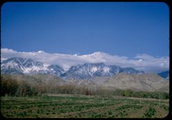
- Description:
- 50 f 9
- Subject:
- Snow, Trees, Croplands, Clouds, Sierra Nevada (Calif. and Nev.), Hills, Mountains, and Whitney, Mount (Calif.)
- Series:
- 14-52
- Creator:
- Cushman, Charles W., 1896-1972
- Date Created:
- 1952-04-08
- Genre:
- Landscape photographs
- Frame Number:
- 16
- County:
- Inyo
- Abstract:
- Mt. Whitney et al. Behind cloud.
- Call Number:
- P06000
- City:
- Lone Pine
- Country:
- United States
- State/Province:
- California
- Alternate Identifier:
- 1452.16
- Persistent URL:
- http://purl.dlib.indiana.edu/iudl/archives/cushman/P06000
- Holding Location:
- Bloomington - University Archives
Wells Library E460
1320 E 10th St.
Bloomington, IN 47405
Contact at archives@indiana.edu, 812-855-1127
-

- Description:
- 50 f 9
- Subject:
- Snow, Houses, Farms, Trees, Croplands, Fences, Whitney, Mount (Calif.), Sierra Nevada (Calif. and Nev.), Hills, Agricultural facilities, Mountains, Williamso...
- Series:
- 14-52
- Creator:
- Cushman, Charles W., 1896-1972
- Date Created:
- 1952-04-08
- Genre:
- Landscape photographs
- Frame Number:
- 15
- County:
- Inyo
- Abstract:
- Mt. Whitney et al. Behind cloud.
- Call Number:
- P05999
- City:
- Lone Pine
- Country:
- United States
- State/Province:
- California
- Alternate Identifier:
- 1452.15
- Persistent URL:
- http://purl.dlib.indiana.edu/iudl/archives/cushman/P05999
- Holding Location:
- Bloomington - University Archives
Wells Library E460
1320 E 10th St.
Bloomington, IN 47405
Contact at archives@indiana.edu, 812-855-1127
-
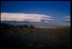
- Description:
- 25 f 9
- Subject:
- Panamint Mountains (Calif.), Deserts, Panamint Range (Calif.), Rocks, Rock formations, Mountains, and Clouds
- Series:
- 14-52
- Creator:
- Cushman, Charles W., 1896-1972
- Date Created:
- 1952-04-07
- Genre:
- Landscape photographs
- Frame Number:
- 14
- County:
- Inyo and San Bernardino
- Abstract:
- White cloud + distant Panamint Mtns. from few miles south of Trona.
- Call Number:
- P05998
- City:
- Trona
- Country:
- United States
- State/Province:
- California
- Physical Description:
- Image was originally mounted in a glass enclosure. Before digitization, the image was removed and placed in a Wess Plastic, Inc. brand, 2" x 2", pl...
- Alternate Identifier:
- 1452.14
- Persistent URL:
- http://purl.dlib.indiana.edu/iudl/archives/cushman/P05998
- Holding Location:
- Bloomington - University Archives
Wells Library E460
1320 E 10th St.
Bloomington, IN 47405
Contact at archives@indiana.edu, 812-855-1127
-
- Description:
- 25 f 8 Pola
- Subject:
- Mountains, Shrubs, Sierra Nevada (Calif. and Nev.), Shadows, and Clouds
- Series:
- 14-52
- Creator:
- Cushman, Charles W., 1896-1972
- Date Created:
- 1952-04-07
- Genre:
- Landscape photographs
- Frame Number:
- 13
- Street Address:
- Ridgecrest-Trona Road
- County:
- Kern and San Bernardino
- Abstract:
- Clouds + mtns in western sky from Ridgecrest-Trona road.
- Call Number:
- P05997
- City:
- Ridgecrest and Trona
- Country:
- United States
- State/Province:
- California
- Alternate Identifier:
- 1452.13
- Persistent URL:
- http://purl.dlib.indiana.edu/iudl/archives/cushman/P05997
- Holding Location:
- Bloomington - University Archives
Wells Library E460
1320 E 10th St.
Bloomington, IN 47405
Contact at archives@indiana.edu, 812-855-1127
-
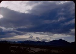
- Description:
- 25 f 11
- Subject:
- Deserts, Mojave Desert (Calif.), Shadows, Mountains, Shrubs, and Clouds
- Series:
- 14-52
- Creator:
- Cushman, Charles W., 1896-1972
- Date Created:
- 1952-04-07
- Genre:
- Landscape photographs
- Frame Number:
- 12
- Street Address:
- United States Highway 6
- County:
- Kern
- Abstract:
- Low dark mtn east of US 6. 10 mi. north of Ricardo.
- Call Number:
- P05996
- City:
- Ricardo
- Country:
- United States
- State/Province:
- California
- Alternate Identifier:
- 1452.12
- Persistent URL:
- http://purl.dlib.indiana.edu/iudl/archives/cushman/P05996
- Holding Location:
- Bloomington - University Archives
Wells Library E460
1320 E 10th St.
Bloomington, IN 47405
Contact at archives@indiana.edu, 812-855-1127
-
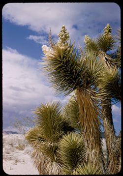
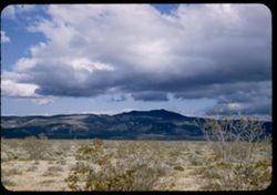
- Description:
- 25 f 11
- Subject:
- Deserts, Mojave Desert (Calif.), Sand, Flowers, Joshua trees, Tree limbs, Shrubs, and Clouds
- Series:
- 14-52
- Creator:
- Cushman, Charles W., 1896-1972
- Date Created:
- 1952-04-07
- Genre:
- Identification photographs
- Frame Number:
- 11
- County:
- Kern
- Abstract:
- Joshua tree near Ricardo.
- Call Number:
- P05995
- City:
- Ricardo
- Country:
- United States
- State/Province:
- California
- Alternate Identifier:
- 1452.11
- Persistent URL:
- http://purl.dlib.indiana.edu/iudl/archives/cushman/P05995
- Holding Location:
- Bloomington - University Archives
Wells Library E460
1320 E 10th St.
Bloomington, IN 47405
Contact at archives@indiana.edu, 812-855-1127
-
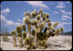
- Description:
- 25 f 11
- Subject:
- Deserts, Mojave Desert (Calif.), Sand, Trees, Joshua trees, Shrubs, Clouds, and Hills
- Series:
- 14-52
- Creator:
- Cushman, Charles W., 1896-1972
- Date Created:
- 1952-04-07
- Genre:
- Identification photographs
- Frame Number:
- 10
- Street Address:
- United States Highway 6
- County:
- Kern
- Abstract:
- Joshua tree near Ricardo.
- Call Number:
- P05994
- City:
- Ricardo
- Country:
- United States
- State/Province:
- California
- Alternate Identifier:
- 1452.10
- Persistent URL:
- http://purl.dlib.indiana.edu/iudl/archives/cushman/P05994
- Holding Location:
- Bloomington - University Archives
Wells Library E460
1320 E 10th St.
Bloomington, IN 47405
Contact at archives@indiana.edu, 812-855-1127
-
- Description:
- 25 f 9
- Subject:
- Croplands, Meadows, Tehachapi Pass (Calif.), Hills, Shrubs, Trees, Grasses, and Fences
- Series:
- 14-52
- Creator:
- Cushman, Charles W., 1896-1972
- Date Created:
- 1952-04-07
- Genre:
- Landscape photographs
- Frame Number:
- 9
- Street Address:
- United States Highway 466
- County:
- Kern
- Abstract:
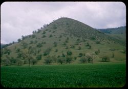
- Peaked foothill between Bakersfield and Tehachapi.
- Call Number:
- P05993
- City:
- Tehachapi and Bakersfield
- Country:
- United States
- State/Province:
- California
- Alternate Identifier:
- 1452.9
- Persistent URL:
- http://purl.dlib.indiana.edu/iudl/archives/cushman/P05993
- Holding Location:
- Bloomington - University Archives
Wells Library E460
1320 E 10th St.
Bloomington, IN 47405
Contact at archives@indiana.edu, 812-855-1127
-
- Description:
- 25 f 11
- Subject:
- Grasses, Tehachapi Mountains (Calif.), Trees, Meadows, Croplands, Clouds, Hills, and Mountains
- Series:
- 14-52
- Creator:
- Cushman, Charles W., 1896-1972
- Date Created:
- 1952-04-07
- Genre:
- Landscape photographs
- Frame Number:
- 8
- Street Address:
- United States Highway 466
- County:
- Kern
- Abstract:
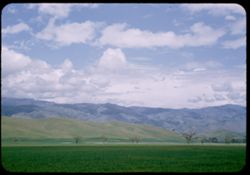
- Along Hwy 466 between Bakersfield and Tehachapi.
- Call Number:
- P05992
- City:
- Tehachapi and Bakersfield
- Country:
- United States
- State/Province:
- California
- Alternate Identifier:
- 1452.8
- Persistent URL:
- http://purl.dlib.indiana.edu/iudl/archives/cushman/P05992
- Holding Location:
- Bloomington - University Archives
Wells Library E460
1320 E 10th St.
Bloomington, IN 47405
Contact at archives@indiana.edu, 812-855-1127
-
- Description:
- 25 f 9
- Subject:
- Grasses, Trees, Meadows, Mountains, Clouds, Hills, and Croplands
- Series:
- 14-52
- Creator:
- Cushman, Charles W., 1896-1972
- Date Created:
- 1952-04-07
- Genre:
- Landscape photographs
- Frame Number:
- 7
- Street Address:
- United States Highway 466
- County:
- Kern
- Abstract:
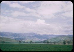
- Along Hwy 466 between Bakersfield and Tehachapi.
- Call Number:
- P05991
- City:
- Tehachapi and Bakersfield
- Country:
- United States
- State/Province:
- California
- Alternate Identifier:
- 1452.7
- Persistent URL:
- http://purl.dlib.indiana.edu/iudl/archives/cushman/P05991
- Holding Location:
- Bloomington - University Archives
Wells Library E460
1320 E 10th St.
Bloomington, IN 47405
Contact at archives@indiana.edu, 812-855-1127
-
- Description:
- 25 f 11
- Subject:
- Rocks, Sequoia National Park (Calif.), Grasses, Trees, Flowers, Mountains, National parks & reserves, Hills, Redbuds, and Shrubs
- Series:
- 14-52
- Creator:
- Cushman, Charles W., 1896-1972
- Date Created:
- 1952-04-06
- Genre:
- Identification photographs
- Frame Number:
- 6
- County:
- Tulare
- Abstract:
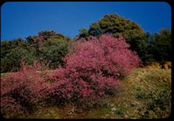
- Red Bud on Mtnside out of Sequoia Park.
- Call Number:
- P05990
- Country:
- United States
- State/Province:
- California
- Alternate Identifier:
- 1452.6
- Persistent URL:
- http://purl.dlib.indiana.edu/iudl/archives/cushman/P05990
- Holding Location:
- Bloomington - University Archives
Wells Library E460
1320 E 10th St.
Bloomington, IN 47405
Contact at archives@indiana.edu, 812-855-1127
-
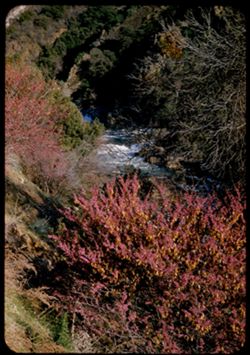
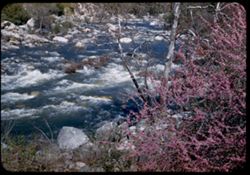
- Description:
- 25 f 9
- Subject:
- Kaweah River (Calif.), Flowers, Tree limbs, Shrubs, Rapids, Hills, Redbuds, and Rivers
- Series:
- 14-52
- Creator:
- Cushman, Charles W., 1896-1972
- Date Created:
- 1952-04-06
- Genre:
- Landscape photographs
- Frame Number:
- 5
- County:
- Tulare
- Abstract:
- Red Bud above the swift Kaweah river.
- Call Number:
- P05989
- Country:
- United States
- State/Province:
- California
- Alternate Identifier:
- 1452.5
- Persistent URL:
- http://purl.dlib.indiana.edu/iudl/archives/cushman/P05989
- Holding Location:
- Bloomington - University Archives
Wells Library E460
1320 E 10th St.
Bloomington, IN 47405
Contact at archives@indiana.edu, 812-855-1127
-
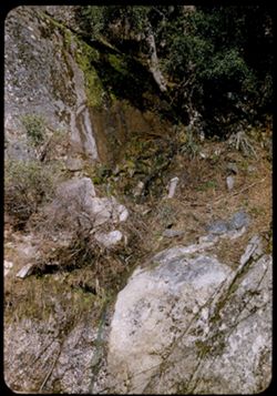
- Description:
- 25 f 9
- Subject:
- Rocks, Granite Spring (Tulare County, Calif.), Sequoia National Park (Calif.), Cliffs, Boulders, Tree limbs, Shrubs, Water, and National parks & reserves
- Series:
- 14-52
- Creator:
- Cushman, Charles W., 1896-1972
- Date Created:
- 1952-04-06
- Genre:
- Snapshots
- Frame Number:
- 4
- County:
- Tulare
- Abstract:
- Run-off alongside Granite Spring.
- Call Number:
- P05988
- Country:
- United States
- State/Province:
- California
- Alternate Identifier:
- 1452.4
- Persistent URL:
- http://purl.dlib.indiana.edu/iudl/archives/cushman/P05988
- Holding Location:
- Bloomington - University Archives
Wells Library E460
1320 E 10th St.
Bloomington, IN 47405
Contact at archives@indiana.edu, 812-855-1127
-
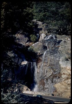
- Description:
- 25 f 11
- Subject:
- Granite Spring (Tulare County, Calif.), Sequoia National Park (Calif.), Roads, Waterfalls, Shadows, Tree limbs, National parks & reserves, Bridges, Cliff...
- Series:
- 14-52
- Creator:
- Cushman, Charles W., 1896-1972
- Date Created:
- 1952-04-06
- Genre:
- Landscape photographs
- Frame Number:
- 3
- County:
- Tulare
- Abstract:
- Granite Spring - where it goes under the road. Elev. 4650 ft.
- Call Number:
- P05987
- Country:
- United States
- State/Province:
- California
- Alternate Identifier:
- 1452.3
- Persistent URL:
- http://purl.dlib.indiana.edu/iudl/archives/cushman/P05987
- Holding Location:
- Bloomington - University Archives
Wells Library E460
1320 E 10th St.
Bloomington, IN 47405
Contact at archives@indiana.edu, 812-855-1127
-
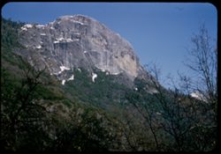
- Description:
- 25 f 11
- Subject:
- Snow, Sequoia National Park (Calif.), Cliffs, Morro Rock (Calif.), Tree limbs, Mountains, National parks & reserves, Palm Sunday, Shrubs, and Rock format...
- Series:
- 14-52
- Creator:
- Cushman, Charles W., 1896-1972
- Date Created:
- 1952-04-06
- Genre:
- Landscape photographs
- Frame Number:
- 2
- County:
- Tulare
- Abstract:
- Moro Rock.
- Call Number:
- P05986
- Country:
- United States
- State/Province:
- California
- Alternate Identifier:
- 1452.2
- Persistent URL:
- http://purl.dlib.indiana.edu/iudl/archives/cushman/P05986
- Holding Location:
- Bloomington - University Archives
Wells Library E460
1320 E 10th St.
Bloomington, IN 47405
Contact at archives@indiana.edu, 812-855-1127
-
- Description:
- 25 f 8 Pola
- Subject:
- Scenic overlooks, Trees, National parks & reserves, Snow, Cliffs, Roads, Sequoia National Park (Calif.), Sierra Nevada (Calif. and Nev.), Mountains, and ...
- Series:
- 14-52
- Creator:
- Cushman, Charles W., 1896-1972
- Date Created:
- 1952-04-06
- Genre:
- Landscape photographs
- Frame Number:
- 1
- Street Address:
- California State Highway 198
- County:
- Tulare
- Abstract:
- High ridge from turnout on road down.
- Call Number:
- P05985
- Country:
- United States
- State/Province:
- California
- Alternate Identifier:
- 1452.1
- Persistent URL:
- http://purl.dlib.indiana.edu/iudl/archives/cushman/P05985
- Holding Location:
- Bloomington - University Archives
Wells Library E460
1320 E 10th St.
Bloomington, IN 47405
Contact at archives@indiana.edu, 812-855-1127
-
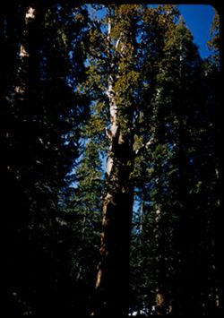
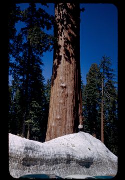
- Description:
- 25 f 8
- Subject:
- Sequoia National Park (Calif.), Trees, Tree limbs, National parks & reserves, Redwoods, General Sherman tree, and Forests
- Series:
- 13-52
- Creator:
- Cushman, Charles W., 1896-1972
- Date Created:
- 1952-04-06
- Genre:
- Identification photographs
- Frame Number:
- 39
- County:
- Tulare
- Abstract:
- Top of Gen Sherman.
- Call Number:
- P05984
- Country:
- United States
- State/Province:
- California
- Alternate Identifier:
- 1352.39
- Persistent URL:
- http://purl.dlib.indiana.edu/iudl/archives/cushman/P05984
- Holding Location:
- Bloomington - University Archives
Wells Library E460
1320 E 10th St.
Bloomington, IN 47405
Contact at archives@indiana.edu, 812-855-1127
-
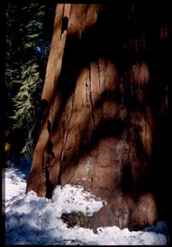
- Description:
- 25 f 6.3
- Subject:
- Snow, Sequoia National Park (Calif.), Shadows, Tree limbs, National parks & reserves, Redwoods, General Sherman tree, and Forests
- Series:
- 13-52
- Creator:
- Cushman, Charles W., 1896-1972
- Date Created:
- 1952-04-06
- Genre:
- Identification photographs
- Frame Number:
- 38
- County:
- Tulare
- Abstract:
- Genl Sherman tree close up.
- Call Number:
- P05983
- Country:
- United States
- State/Province:
- California
- Physical Description:
- Image was originally mounted in a glass enclosure. Before digitization, the image was removed and placed in a Wess Plastic, Inc. brand, 2" x 2", pl...
- Alternate Identifier:
- 1352.38
- Persistent URL:
- http://purl.dlib.indiana.edu/iudl/archives/cushman/P05983
- Holding Location:
- Bloomington - University Archives
Wells Library E460
1320 E 10th St.
Bloomington, IN 47405
Contact at archives@indiana.edu, 812-855-1127
-
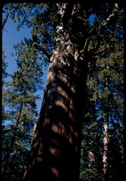
- Description:
- 25 f 6.3
- Subject:
- Sequoia National Park (Calif.), Trees, Tree limbs, National parks & reserves, Redwoods, General Sherman tree, and Forests
- Series:
- 13-52
- Creator:
- Cushman, Charles W., 1896-1972
- Date Created:
- 1952-04-06
- Genre:
- Identification photographs
- Frame Number:
- 37
- County:
- Tulare
- Abstract:
- Genl Sherman tree.
- Call Number:
- P05982
- Country:
- United States
- State/Province:
- California
- Alternate Identifier:
- 1352.37
- Persistent URL:
- http://purl.dlib.indiana.edu/iudl/archives/cushman/P05982
- Holding Location:
- Bloomington - University Archives
Wells Library E460
1320 E 10th St.
Bloomington, IN 47405
Contact at archives@indiana.edu, 812-855-1127
-
- Description:
- 25 f 4.5
- Subject:
- Tree limbs, Redwoods, Forests, People, Snow, Sequoia National Park (Calif.), Trails & paths, General Sherman tree, and National parks & reserves
- Series:
- 13-52
- Creator:
- Cushman, Charles W., 1896-1972
- Date Created:
- 1952-04-06
- Genre:
- Identification photographs
- Frame Number:
- 36
- County:
- Tulare
- Abstract:
- Genl Sherman tree.
- Call Number:
- P05981
- Country:
- United States
- State/Province:
- California
- Physical Description:
- Image was originally mounted in a glass enclosure. Before digitization, the image was removed and placed in a Wess Plastic, Inc. brand, 2" x 2", pl...
- Alternate Identifier:
- 1352.36
- Persistent URL:
- http://purl.dlib.indiana.edu/iudl/archives/cushman/P05981
- Holding Location:
- Bloomington - University Archives
Wells Library E460
1320 E 10th St.
Bloomington, IN 47405
Contact at archives@indiana.edu, 812-855-1127
-
- Description:
- 25 f 9
- Subject:
- Snow, Sequoia National Park (Calif.), Roads, Trees, Tree limbs, Buildings, National parks & reserves, Redwoods, People, and Forests
- Series:
- 13-52
- Creator:
- Cushman, Charles W., 1896-1972
- Date Created:
- 1952-04-06
- Genre:
- Identification photographs
- Frame Number:
- 35
- County:
- Tulare
- Abstract:
- Redwoods + snow banks.
- Call Number:
- P05980
- Country:
- United States
- State/Province:
- California
- Alternate Identifier:
- 1352.35
- Persistent URL:
- http://purl.dlib.indiana.edu/iudl/archives/cushman/P05980
- Holding Location:
- Bloomington - University Archives
Wells Library E460
1320 E 10th St.
Bloomington, IN 47405
Contact at archives@indiana.edu, 812-855-1127
-
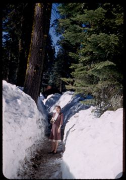
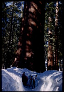
- Description:
- 25 f 8
- Subject:
- Tree limbs, Redwoods, Forests, Women, Snow, Sequoia National Park (Calif.), Trails & paths, National parks & reserves, and Sierra Nevada (Calif. and ...
- Series:
- 13-52
- Creator:
- Cushman, Charles W., 1896-1972
- Date Created:
- 1952-04-06
- Genre:
- Portraits
- Frame Number:
- 34
- County:
- Tulare
- Persons Pictured:
- Cushman, Jean
- Abstract:
- Jean between snow banks.
- Call Number:
- P05979
- Country:
- United States
- State/Province:
- California
- Alternate Identifier:
- 1352.34
- Persistent URL:
- http://purl.dlib.indiana.edu/iudl/archives/cushman/P05979
- Holding Location:
- Bloomington - University Archives
Wells Library E460
1320 E 10th St.
Bloomington, IN 47405
Contact at archives@indiana.edu, 812-855-1127
-
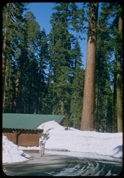
- Description:
- 25 f 10
- Subject:
- Snow, Sequoia National Park (Calif.), Trees, Tree limbs, Buildings, National parks & reserves, Trucks, Redwoods, People, Park headquarters, and Forests
- Series:
- 13-52
- Creator:
- Cushman, Charles W., 1896-1972
- Date Created:
- 1952-04-06
- Genre:
- Identification photographs
- Frame Number:
- 33
- County:
- Tulare
- Abstract:
- Redwoods + packed snow. Pk Hdqrs.
- Call Number:
- P05978
- Country:
- United States
- State/Province:
- California
- Alternate Identifier:
- 1352.33
- Persistent URL:
- http://purl.dlib.indiana.edu/iudl/archives/cushman/P05978
- Holding Location:
- Bloomington - University Archives
Wells Library E460
1320 E 10th St.
Bloomington, IN 47405
Contact at archives@indiana.edu, 812-855-1127
-
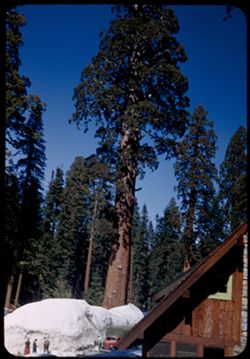
- Description:
- 25 f 11
- Subject:
- Park headquarters, National parks & reserves, Men, Redwoods, Forests, Snow, Trees, Sequoia National Park (Calif.), Tree limbs, and Automobiles
- Series:
- 13-52
- Creator:
- Cushman, Charles W., 1896-1972
- Date Created:
- 1952-04-06
- Genre:
- Identification photographs
- Frame Number:
- 32
- County:
- Tulare
- Abstract:
- Giant redwood - Pk Hdqurtrs. The Sentinel.
- Call Number:
- P05977
- Country:
- United States
- State/Province:
- California
- Physical Description:
- masked.
- Alternate Identifier:
- 1352.32
- Persistent URL:
- http://purl.dlib.indiana.edu/iudl/archives/cushman/P05977
- Holding Location:
- Bloomington - University Archives
Wells Library E460
1320 E 10th St.
Bloomington, IN 47405
Contact at archives@indiana.edu, 812-855-1127
-
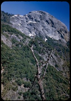
- Description:
- 25 f 9
- Subject:
- National parks & reserves, Cliffs, Mountains, Shrubs, Snow, Trees, Sequoia National Park (Calif.), Morro Rock (Calif.), Rock formations, and Tree limbs
- Series:
- 13-52
- Creator:
- Cushman, Charles W., 1896-1972
- Date Created:
- 1952-04-06
- Genre:
- Landscape photographs
- Frame Number:
- 31
- County:
- Tulare
- Abstract:
- High rock face (Moro Rock) + dead tree.
- Call Number:
- P05976
- Country:
- United States
- State/Province:
- California
- Alternate Identifier:
- 1352.31
- Persistent URL:
- http://purl.dlib.indiana.edu/iudl/archives/cushman/P05976
- Holding Location:
- Bloomington - University Archives
Wells Library E460
1320 E 10th St.
Bloomington, IN 47405
Contact at archives@indiana.edu, 812-855-1127
-
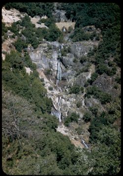
- Description:
- 25 f 9
- Subject:
- Tree limbs, Roads, Cliffs, Bridges, Shrubs, Trees, Sequoia National Park (Calif.), Retaining walls, Rock formations, National parks & reserves, and Water...
- Series:
- 13-52
- Creator:
- Cushman, Charles W., 1896-1972
- Date Created:
- 1952-04-06
- Genre:
- Landscape photographs
- Frame Number:
- 30
- County:
- Tulare
- Abstract:
- Multiple falls. Granite Spring.
- Call Number:
- P05975
- Country:
- United States
- State/Province:
- California
- Alternate Identifier:
- 1352.30
- Persistent URL:
- http://purl.dlib.indiana.edu/iudl/archives/cushman/P05975
- Holding Location:
- Bloomington - University Archives
Wells Library E460
1320 E 10th St.
Bloomington, IN 47405
Contact at archives@indiana.edu, 812-855-1127
-
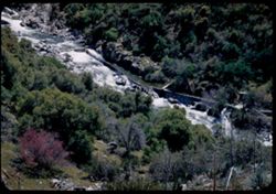
- Description:
- 25 f 9
- Subject:
- Rocks, Kaweah River (Calif.), Canyons, Grasses, Aqueducts, Trees, Boulders, National parks & reserves, Rapids, Redbuds, Rivers, Sequoia National Park (Ca...
- Series:
- 13-52
- Creator:
- Cushman, Charles W., 1896-1972
- Date Created:
- 1952-04-06
- Genre:
- Landscape photographs
- Frame Number:
- 29
- County:
- Tulare
- Abstract:
- Looking down at same scene from dif. angle.
- Call Number:
- P05974
- Country:
- United States
- State/Province:
- California
- Alternate Identifier:
- 1352.29
- Persistent URL:
- http://purl.dlib.indiana.edu/iudl/archives/cushman/P05974
- Holding Location:
- Bloomington - University Archives
Wells Library E460
1320 E 10th St.
Bloomington, IN 47405
Contact at archives@indiana.edu, 812-855-1127
-
- Description:
- 25 f 10
- Subject:
- Rocks, Sequoia National Park (Calif.), Roads, Automobiles, Trees, Boulders, Shrubs, Hills, and National parks & reserves
- Series:
- 13-52
- Creator:
- Cushman, Charles W., 1896-1972
- Date Created:
- 1952-04-06
- Genre:
- Snapshots
- Frame Number:
- 27
- County:
- Tulare
- Abstract:
- Rock over road - Sequoia Nat'l Park.
- Call Number:
- P05972
- Country:
- United States
- State/Province:
- California
- Alternate Identifier:
- 1352.27
- Persistent URL:
- http://purl.dlib.indiana.edu/iudl/archives/cushman/P05972
- Holding Location:
- Bloomington - University Archives
Wells Library E460
1320 E 10th St.
Bloomington, IN 47405
Contact at archives@indiana.edu, 812-855-1127
-
- Description:
- 25 f 9
- Subject:
- Rocks, Kaweah River (Calif.), Canyons, Aqueducts, Boulders, National parks & reserves, Rapids, Rivers, Sequoia National Park (Calif.), and Shrubs
- Series:
- 13-52
- Creator:
- Cushman, Charles W., 1896-1972
- Date Created:
- 1952-04-06
- Genre:
- Landscape photographs
- Frame Number:
- 28
- County:
- Tulare
- Abstract:
- Acqueduct leads off at rapids of Kaweah river.
- Call Number:
- P05973
- Country:
- United States
- State/Province:
- California
- Alternate Identifier:
- 1352.28
- Persistent URL:
- http://purl.dlib.indiana.edu/iudl/archives/cushman/P05973
- Holding Location:
- Bloomington - University Archives
Wells Library E460
1320 E 10th St.
Bloomington, IN 47405
Contact at archives@indiana.edu, 812-855-1127
-
- Description:
- 25 f 11
- Subject:
- Kaweah River (Calif.), Tree limbs, Flowers, Shrubs, Sequoia National Park (Calif.), Rivers, National parks & reserves, Redbuds, Rocks, and Rapids
- Series:
- 13-52
- Creator:
- Cushman, Charles W., 1896-1972
- Date Created:
- 1952-04-06
- Genre:
- Landscape photographs
- Frame Number:
- 26
- County:
- Tulare
- Abstract:
- Looking down at rapids of Kaweah river past Red Bud tree.
- Call Number:
- P05971
- Country:
- United States
- State/Province:
- California
- Alternate Identifier:
- 1352.26
- Persistent URL:
- http://purl.dlib.indiana.edu/iudl/archives/cushman/P05971
- Holding Location:
- Bloomington - University Archives
Wells Library E460
1320 E 10th St.
Bloomington, IN 47405
Contact at archives@indiana.edu, 812-855-1127
-
- Description:
- 25 f 6.3 Pola
- Subject:
- Snow, Sequoia National Park (Calif.), Grasses, Roads, Automobiles, Trees, Mountains, Fences, National parks & reserves, Sierra Nevada (Calif. and Nev.), ...
- Series:
- 13-52
- Creator:
- Cushman, Charles W., 1896-1972
- Date Created:
- 1952-04-06
- Genre:
- Landscape photographs
- Frame Number:
- 25
- County:
- Tulare
- Abstract:
- High Sierras seen up road to Sequoia Pk.
- Call Number:
- P05970
- Country:
- United States
- State/Province:
- California
- Alternate Identifier:
- 1352.25
- Persistent URL:
- http://purl.dlib.indiana.edu/iudl/archives/cushman/P05970
- Holding Location:
- Bloomington - University Archives
Wells Library E460
1320 E 10th St.
Bloomington, IN 47405
Contact at archives@indiana.edu, 812-855-1127
-
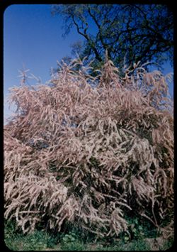
- Description:
- 25 f 11
- Subject:
- Grasses, Tamarix, Tree limbs, Shrubs, and Tamarisk
- Series:
- 13-52
- Creator:
- Cushman, Charles W., 1896-1972
- Date Created:
- 1952-04-06
- Genre:
- Identification photographs
- Frame Number:
- 23
- Street Address:
- Lindsay Road
- County:
- Tulare
- Abstract:
- Roadside tamarisk - Tulare - lindsay road.
- Call Number:
- P05968
- City:
- Tulare
- Country:
- United States
- State/Province:
- California
- Alternate Identifier:
- 1352.23
- Persistent URL:
- http://purl.dlib.indiana.edu/iudl/archives/cushman/P05968
- Holding Location:
- Bloomington - University Archives
Wells Library E460
1320 E 10th St.
Bloomington, IN 47405
Contact at archives@indiana.edu, 812-855-1127
-
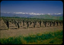
- Description:
- 25 f 7 Pola
- Subject:
- Wildflowers, Grapevines, Grasses, Mountains, Wine industry, Grapes, Sierra Nevada (Calif. and Nev.), Hills, Snow, and Croplands
- Series:
- 13-52
- Creator:
- Cushman, Charles W., 1896-1972
- Date Created:
- 1952-04-06
- Genre:
- Landscape photographs
- Frame Number:
- 24
- Street Address:
- California State Highway 198
- County:
- Tulare
- Abstract:
- High ridge of highest Sierra Nevadas from Calif. Hwy 198 east.
- Call Number:
- P05969
- City:
- Visalia
- Country:
- United States
- State/Province:
- California
- Alternate Identifier:
- 1352.24
- Persistent URL:
- http://purl.dlib.indiana.edu/iudl/archives/cushman/P05969
- Holding Location:
- Bloomington - University Archives
Wells Library E460
1320 E 10th St.
Bloomington, IN 47405
Contact at archives@indiana.edu, 812-855-1127
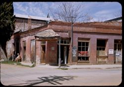
-
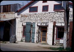
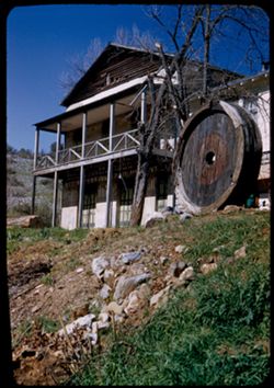
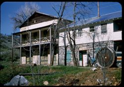
- Description:
- 25 f 11
- Subject:
- Historic buildings, P. L. Traver Building (Murphys, Calif.), Boulders, Signs (Notices), Streets, Tree limbs, Cities & towns, Sidewalks, Windows, Doors &a...
- Series:
- 13-52
- Creator:
- Cushman, Charles W., 1896-1972
- Date Created:
- 1952-04-05
- Genre:
- Architectural photographs
- Frame Number:
- 22
- County:
- Calaveras
- Abstract:
- At Murphys = P L Traver Bldg.
- Call Number:
- P05967
- City:
- Murphys
- Country:
- United States
- State/Province:
- California
- Alternate Identifier:
- 1352.22
- Persistent URL:
- http://purl.dlib.indiana.edu/iudl/archives/cushman/P05967
- Holding Location:
- Bloomington - University Archives
Wells Library E460
1320 E 10th St.
Bloomington, IN 47405
Contact at archives@indiana.edu, 812-855-1127
-
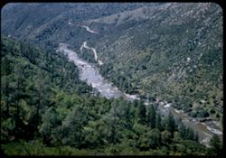
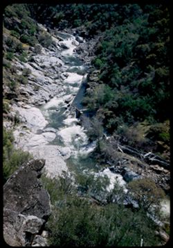
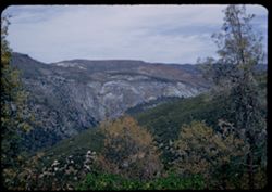
- Description:
- 25 f 8
- Subject:
- Rocks, Canyons, Roads, Trees, Stanislaus River (Calif.), Shrubs, Bridges, Hills, Rivers, and Rapids
- Series:
- 13-52
- Creator:
- Cushman, Charles W., 1896-1972
- Date Created:
- 1952-04-05
- Genre:
- Landscape photographs
- Frame Number:
- 21
- County:
- Tuolumne
- Abstract:
- Looking down into Stanislaus river canyon.
- Call Number:
- P05966
- City:
- Columbia
- Country:
- United States
- State/Province:
- California
- Alternate Identifier:
- 1352.21
- Persistent URL:
- http://purl.dlib.indiana.edu/iudl/archives/cushman/P05966
- Holding Location:
- Bloomington - University Archives
Wells Library E460
1320 E 10th St.
Bloomington, IN 47405
Contact at archives@indiana.edu, 812-855-1127
-
- Description:
- 25 f 9
- Subject:
- Tree limbs, Cities & towns, Streets, Sidewalks, Galleries & museums, Electric lines, Buildings, Signs (Notices), Mother Lode Art Galleries (Columbia,...
- Series:
- 13-52
- Creator:
- Cushman, Charles W., 1896-1972
- Date Created:
- 1952-04-05
- Genre:
- Architectural photographs
- Frame Number:
- 19
- County:
- Tuolumne
- Abstract:
- A corner in Columbia.
- Call Number:
- P05964
- City:
- Columbia
- Country:
- United States
- State/Province:
- California
- Alternate Identifier:
- 1352.19
- Persistent URL:
- http://purl.dlib.indiana.edu/iudl/archives/cushman/P05964
- Holding Location:
- Bloomington - University Archives
Wells Library E460
1320 E 10th St.
Bloomington, IN 47405
Contact at archives@indiana.edu, 812-855-1127
-
- Description:
- 25 f 11
- Subject:
- Canyons, Trees, Stanislaus River (Calif.), Tree limbs, Shrubs, and Hills
- Series:
- 13-52
- Creator:
- Cushman, Charles W., 1896-1972
- Date Created:
- 1952-04-05
- Genre:
- Landscape photographs
- Frame Number:
- 20
- Street Address:
- Columbia Vallecito Highway and Columbia-Vallecito Road
- County:
- Tuolumne and Calaveras
- Abstract:
- Canyon of the Stanislaus river - seen from Columbia Vallecito Hwy.
- Call Number:
- P05965
- City:
- Columbia
- Country:
- United States
- State/Province:
- California
- Alternate Identifier:
- 1352.20
- Persistent URL:
- http://purl.dlib.indiana.edu/iudl/archives/cushman/P05965
- Holding Location:
- Bloomington - University Archives
Wells Library E460
1320 E 10th St.
Bloomington, IN 47405
Contact at archives@indiana.edu, 812-855-1127
-
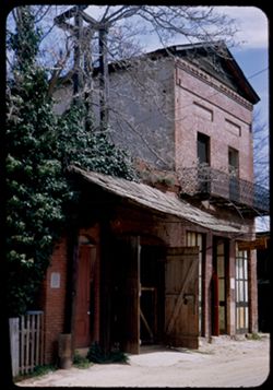
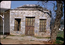
- Description:
- 25 f 6.3
- Subject:
- Balconies, Drugstores, Fire stations, McChesney & Parsons Drug Store (Columbia, Calif.), Stables, Signs (Notices), Tree limbs, Fences, Doors & doorwa...
- Series:
- 13-52
- Creator:
- Cushman, Charles W., 1896-1972
- Date Created:
- 1952-04-05
- Genre:
- Architectural photographs
- Frame Number:
- 18
- County:
- Tuolumne
- Abstract:
- Old fire enginehouse and McChesney + Parsons Drug Store, 1856.
- Call Number:
- P05963
- City:
- Columbia
- Country:
- United States
- State/Province:
- California
- Alternate Identifier:
- 1352.18
- Persistent URL:
- http://purl.dlib.indiana.edu/iudl/archives/cushman/P05963
- Holding Location:
- Bloomington - University Archives
Wells Library E460
1320 E 10th St.
Bloomington, IN 47405
Contact at archives@indiana.edu, 812-855-1127
-
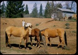
- Description:
- 25 f 9
- Subject:
- Agricultural machinery & implements, Horses, Trees, Fences, Shrubs, and Storage facilities
- Series:
- 13-52
- Creator:
- Cushman, Charles W., 1896-1972
- Date Created:
- 1952-04-05
- Genre:
- Snapshots
- Frame Number:
- 17
- County:
- Tuolumne
- Abstract:
- 4 horses, young + not so young. Columbia.
- Call Number:
- P05962
- City:
- Columbia
- Country:
- United States
- State/Province:
- California
- Alternate Identifier:
- 1352.17
- Persistent URL:
- http://purl.dlib.indiana.edu/iudl/archives/cushman/P05962
- Holding Location:
- Bloomington - University Archives
Wells Library E460
1320 E 10th St.
Bloomington, IN 47405
Contact at archives@indiana.edu, 812-855-1127
-
- Description:
- 25 f 9+
- Subject:
- Tree limbs, Mining, Shrubs, Boulders, Rocks, Sluices, Hydraulic mining, and Grasses
- Series:
- 13-52
- Creator:
- Cushman, Charles W., 1896-1972
- Date Created:
- 1952-04-05
- Genre:
- Snapshots
- Frame Number:
- 16
- County:
- Tuolumne
- Abstract:
- Great sluiced rocks near Columbia, Calif.
- Call Number:
- P05961
- City:
- Columbia
- Country:
- United States
- State/Province:
- California
- Alternate Identifier:
- 1352.16
- Persistent URL:
- http://purl.dlib.indiana.edu/iudl/archives/cushman/P05961
- Holding Location:
- Bloomington - University Archives
Wells Library E460
1320 E 10th St.
Bloomington, IN 47405
Contact at archives@indiana.edu, 812-855-1127
-
- Description:
- 25 f 11
- Subject:
- Tree limbs, Mining, Shrubs, Boulders, Rocks, Sluices, Hydraulic mining, and Grasses
- Series:
- 13-52
- Creator:
- Cushman, Charles W., 1896-1972
- Date Created:
- 1952-04-05
- Genre:
- Snapshots
- Frame Number:
- 15
- County:
- Tuolumne
- Abstract:
- Great sluiced rocks near Columbia, Calif.
- Call Number:
- P05960
- City:
- Columbia
- Country:
- United States
- State/Province:
- California
- Alternate Identifier:
- 1352.15
- Persistent URL:
- http://purl.dlib.indiana.edu/iudl/archives/cushman/P05960
- Holding Location:
- Bloomington - University Archives
Wells Library E460
1320 E 10th St.
Bloomington, IN 47405
Contact at archives@indiana.edu, 812-855-1127
-
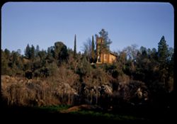
- Description:
- 25 f 8
- Subject:
- Rocks, Trees, Mining, Hydraulic mining, Churches, Shrubs, Sunrises & sunsets, Sluices, Towers, and Boulders
- Series:
- 13-52
- Creator:
- Cushman, Charles W., 1896-1972
- Date Created:
- 1952-04-04
- Genre:
- Landscape photographs and Views
- Frame Number:
- 14
- County:
- Tuolumne
- Abstract:
- The Old church seen across the sluiced rocks of '49.
- Call Number:
- P05959
- City:
- Columbia
- Country:
- United States
- State/Province:
- California
- Alternate Identifier:
- 1352.14
- Persistent URL:
- http://purl.dlib.indiana.edu/iudl/archives/cushman/P05959
- Holding Location:
- Bloomington - University Archives
Wells Library E460
1320 E 10th St.
Bloomington, IN 47405
Contact at archives@indiana.edu, 812-855-1127
-
- Description:
- 25 f 6.3
- Subject:
- Rocks, Grasses, Trees, Boulders, Arches, Churches, Shrubs, Windows, Hills, Doors & doorways, and Towers
- Series:
- 13-52
- Creator:
- Cushman, Charles W., 1896-1972
- Date Created:
- 1952-04-04
- Genre:
- Architectural photographs
- Frame Number:
- 13
- County:
- Tuolumne
- Abstract:
- Old church on hill. Near sunset.
- Call Number:
- P05958
- City:
- Columbia
- Country:
- United States
- State/Province:
- California
- Alternate Identifier:
- 1352.13
- Persistent URL:
- http://purl.dlib.indiana.edu/iudl/archives/cushman/P05958
- Holding Location:
- Bloomington - University Archives
Wells Library E460
1320 E 10th St.
Bloomington, IN 47405
Contact at archives@indiana.edu, 812-855-1127
-
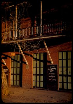
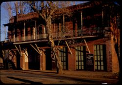
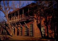
- Description:
- 25 f 7
- Subject:
- Balconies, Theaters, Old Columbia Hotel (Columbia, Calif.), Signs (Notices), Tree limbs, Sidewalks, Hotels, Fallon House Theatre (Columbia, Calif.), and Door...
- Series:
- 13-52
- Creator:
- Cushman, Charles W., 1896-1972
- Date Created:
- 1952-04-04
- Genre:
- Architectural photographs
- Frame Number:
- 12
- County:
- Tuolumne
- Abstract:
- Old Columbia Hotel + Fallon house theatre.
- Call Number:
- P05957
- City:
- Columbia
- Country:
- United States
- State/Province:
- California
- Alternate Identifier:
- 1352.12
- Persistent URL:
- http://purl.dlib.indiana.edu/iudl/archives/cushman/P05957
- Holding Location:
- Bloomington - University Archives
Wells Library E460
1320 E 10th St.
Bloomington, IN 47405
Contact at archives@indiana.edu, 812-855-1127
-
- Description:
- 25 f 8
- Subject:
- Hotels, Balconies, Cities & towns, Streets, Windows, Fallon House Theatre (Columbia, Calif.), Old Columbia Hotel (Columbia, Calif.), Signs (Notices), Doo...
- Series:
- 13-52
- Creator:
- Cushman, Charles W., 1896-1972
- Date Created:
- 1952-04-04
- Genre:
- Architectural photographs
- Frame Number:
- 11
- County:
- Tuolumne
- Abstract:
- Old Columbia Hotel + Fallon house theatre.
- Call Number:
- P05956
- City:
- Columbia
- Country:
- United States
- State/Province:
- California
- Alternate Identifier:
- 1352.11
- Persistent URL:
- http://purl.dlib.indiana.edu/iudl/archives/cushman/P05956
- Holding Location:
- Bloomington - University Archives
Wells Library E460
1320 E 10th St.
Bloomington, IN 47405
Contact at archives@indiana.edu, 812-855-1127
-
- Description:
- 25 f 8+
- Subject:
- Balconies, Theaters, Old Columbia Hotel (Columbia, Calif.), Signs (Notices), Streets, Tree limbs, Cities & towns, Fences, Hotels, Windows, Fallon House T...
- Series:
- 13-52
- Creator:
- Cushman, Charles W., 1896-1972
- Date Created:
- 1952-04-04
- Genre:
- Architectural photographs
- Frame Number:
- 10
- County:
- Tuolumne
- Abstract:
- Old Columbia Hotel + Fallon house theatre.
- Call Number:
- P05955
- City:
- Columbia
- Country:
- United States
- State/Province:
- California
- Alternate Identifier:
- 1352.10
- Persistent URL:
- http://purl.dlib.indiana.edu/iudl/archives/cushman/P05955
- Holding Location:
- Bloomington - University Archives
Wells Library E460
1320 E 10th St.
Bloomington, IN 47405
Contact at archives@indiana.edu, 812-855-1127
-
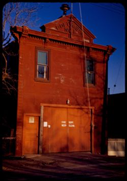
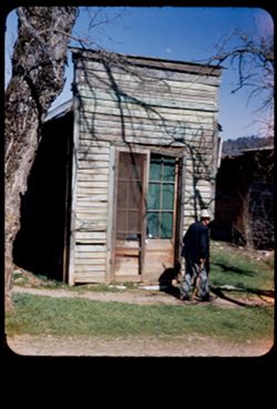
- Description:
- 25 f 8
- Subject:
- Fences, Tree limbs, Facades, Doors & doorways, Shadows, Windows, Fire stations, Signs (Notices), and Electric lines
- Series:
- 13-52
- Creator:
- Cushman, Charles W., 1896-1972
- Date Created:
- 1952-04-04
- Genre:
- Architectural photographs
- Frame Number:
- 9
- County:
- Tuolumne
- Abstract:
- Columbia - old fire house.
- Call Number:
- P05954
- City:
- Columbia
- Country:
- United States
- State/Province:
- California
- Alternate Identifier:
- 1352.9
- Persistent URL:
- http://purl.dlib.indiana.edu/iudl/archives/cushman/P05954
- Holding Location:
- Bloomington - University Archives
Wells Library E460
1320 E 10th St.
Bloomington, IN 47405
Contact at archives@indiana.edu, 812-855-1127
-
- Description:
- 25 f 9
- Subject:
- Hills, Trees, and Buildings
- Series:
- 13-52
- Creator:
- Cushman, Charles W., 1896-1972
- Date Created:
- 1952-04-04
- Genre:
- Cityscape photographs
- Frame Number:
- 8
- Street Address:
- California State Highway 49
- County:
- Amador
- Abstract:
- Looking down on town of Sutter Creek from SW on Cal 49.
- Call Number:
- P05953
- City:
- Sutter Creek
- Country:
- United States
- State/Province:
- California
- Alternate Identifier:
- 1352.8
- Persistent URL:
- http://purl.dlib.indiana.edu/iudl/archives/cushman/P05953
- Holding Location:
- Bloomington - University Archives
Wells Library E460
1320 E 10th St.
Bloomington, IN 47405
Contact at archives@indiana.edu, 812-855-1127
-
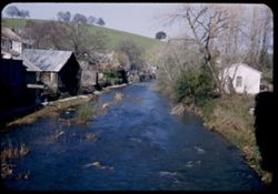
- Description:
- 25 f 8.5
- Subject:
- Houses, Trees, Shadows, Buildings, Shrubs, Hills, and Streams
- Series:
- 13-52
- Creator:
- Cushman, Charles W., 1896-1972
- Date Created:
- 1952-04-04
- Genre:
- Landscape photographs
- Frame Number:
- 7
- County:
- Amador
- Abstract:
- Sutter Creek in Sutter Creek.
- Call Number:
- P05952
- City:
- Sutter Creek
- Country:
- United States
- State/Province:
- California
- Alternate Identifier:
- 1352.7
- Persistent URL:
- http://purl.dlib.indiana.edu/iudl/archives/cushman/P05952
- Holding Location:
- Bloomington - University Archives
Wells Library E460
1320 E 10th St.
Bloomington, IN 47405
Contact at archives@indiana.edu, 812-855-1127
-
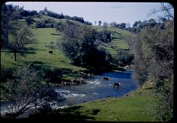
- Description:
- 25 f 8
- Subject:
- Grasses, Mother Lode (Calif.), Trees, Tree limbs, Shrubs, Cows, Rapids, Hills, and Streams
- Series:
- 13-52
- Creator:
- Cushman, Charles W., 1896-1972
- Date Created:
- 1952-04-04
- Genre:
- Landscape photographs
- Frame Number:
- 6
- County:
- Amador
- Abstract:
- Cows in Sutter Creek.
- Call Number:
- P05951
- City:
- Sutter Creek
- Country:
- United States
- State/Province:
- California
- Alternate Identifier:
- 1352.6
- Persistent URL:
- http://purl.dlib.indiana.edu/iudl/archives/cushman/P05951
- Holding Location:
- Bloomington - University Archives
Wells Library E460
1320 E 10th St.
Bloomington, IN 47405
Contact at archives@indiana.edu, 812-855-1127
-
- Description:
- 25 f 11
- Subject:
- Tree limbs, Gold rushes, Facades, Roads, Buildings, Offices, Walkways, Doors & doorways, and Assaying
- Series:
- 13-52
- Creator:
- Cushman, Charles W., 1896-1972
- Date Created:
- 1952-04-04
- Genre:
- Architectural photographs
- Frame Number:
- 5
- County:
- Amador
- Abstract:
- Old Assay office again (Volcano).
- Call Number:
- P05950
- City:
- Volcano
- Country:
- United States
- State/Province:
- California
- Alternate Identifier:
- 1352.5
- Persistent URL:
- http://purl.dlib.indiana.edu/iudl/archives/cushman/P05950
- Holding Location:
- Bloomington - University Archives
Wells Library E460
1320 E 10th St.
Bloomington, IN 47405
Contact at archives@indiana.edu, 812-855-1127
-
- Description:
- 25 f 9
- Subject:
- Rocks, Balconies, Fraternal organizations, Adobe buildings, Printing industry, Tree limbs, Shrubs, Hills, and Masonic Hall
- Series:
- 13-52
- Creator:
- Cushman, Charles W., 1896-1972
- Date Created:
- 1952-04-04
- Genre:
- Architectural photographs
- Frame Number:
- 4
- County:
- Amador
- Abstract:
- Old print shop - now Masonic Hall blt. about 1854 face marble - no mortar - rest is adobe, stone + brick (no elec.).
- Call Number:
- P05949
- City:
- Volcano
- Country:
- United States
- State/Province:
- California
- Alternate Identifier:
- 1352.4
- Persistent URL:
- http://purl.dlib.indiana.edu/iudl/archives/cushman/P05949
- Holding Location:
- Bloomington - University Archives
Wells Library E460
1320 E 10th St.
Bloomington, IN 47405
Contact at archives@indiana.edu, 812-855-1127
-
- Description:
- 25 f 9
- Subject:
- Masonic Hall, Tree limbs, Fraternal organizations, Hills, Masonic buildings, Shrubs, Stonework, Rocks, Printing industry, Adobe buildings, and Trucks
- Series:
- 13-52
- Creator:
- Cushman, Charles W., 1896-1972
- Date Created:
- 1952-04-04
- Genre:
- Architectural photographs
- Frame Number:
- 3
- County:
- Amador
- Abstract:
- Old print shop - now Masonic Hall blt. about 1854 face marble - no mortar - rest is adobe, stone + brick (no elec.).
- Call Number:
- P05948
- City:
- Volcano
- Country:
- United States
- State/Province:
- California
- Alternate Identifier:
- 1352.3
- Persistent URL:
- http://purl.dlib.indiana.edu/iudl/archives/cushman/P05948
- Holding Location:
- Bloomington - University Archives
Wells Library E460
1320 E 10th St.
Bloomington, IN 47405
Contact at archives@indiana.edu, 812-855-1127
-
- Description:
- 25 F 11
- Subject:
- Stores & shops, Roads, Stonework, Signs (Notices), Tree limbs, Sidewalks, Windows, Doors & doorways, Shutters, and Buildings
- Series:
- 13-52
- Creator:
- Cushman, Charles W., 1896-1972
- Date Created:
- 1952-04-04
- Genre:
- Architectural photographs
- Frame Number:
- 2
- County:
- Amador
- Abstract:
- Old stone store front.
- Call Number:
- P05947
- City:
- Volcano
- Country:
- United States
- State/Province:
- California
- Alternate Identifier:
- 1352.2
- Persistent URL:
- http://purl.dlib.indiana.edu/iudl/archives/cushman/P05947
- Holding Location:
- Bloomington - University Archives
Wells Library E460
1320 E 10th St.
Bloomington, IN 47405
Contact at archives@indiana.edu, 812-855-1127
-
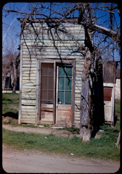
- Description:
- 25 f 9
- Subject:
- Men, Grasses, Facades, Walkways, Tree limbs, Buildings, Assaying, Doors & doorways, and Offices
- Series:
- 13-52
- Creator:
- Cushman, Charles W., 1896-1972
- Date Created:
- 1952-04-04
- Genre:
- Architectural photographs
- Frame Number:
- 1
- County:
- Amador
- Abstract:
- Old narrow frame.
- Call Number:
- P05946
- City:
- Volcano
- Country:
- United States
- State/Province:
- California
- Physical Description:
- masked.
- Alternate Identifier:
- 1352.1
- Persistent URL:
- http://purl.dlib.indiana.edu/iudl/archives/cushman/P05946
- Holding Location:
- Bloomington - University Archives
Wells Library E460
1320 E 10th St.
Bloomington, IN 47405
Contact at archives@indiana.edu, 812-855-1127
-
- Description:
- 25 f 9
- Subject:
- Grasses, Trails & paths, Logs, and Hills
- Series:
- 12-52
- Creator:
- Cushman, Charles W., 1896-1972
- Date Created:
- 1952-04-04
- Genre:
- Identification photographs
- Frame Number:
- 39
- County:
- Amador
- Abstract:
- Leaning trees between lone + Jackson.
- Call Number:
- P05945
- City:
- Jackson and Ione
- Country:
- United States
- State/Province:
- California
- Alternate Identifier:
- 1252.39
- Persistent URL:
- http://purl.dlib.indiana.edu/iudl/archives/cushman/P05945
- Holding Location:
- Bloomington - University Archives
Wells Library E460
1320 E 10th St.
Bloomington, IN 47405
Contact at archives@indiana.edu, 812-855-1127
-
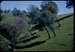
- Description:
- 25 f 9
- Subject:
- Grasses, Trails & paths, Trees, and Hills
- Series:
- 12-52
- Creator:
- Cushman, Charles W., 1896-1972
- Date Created:
- 1952-04-04
- Genre:
- Identification photographs
- Frame Number:
- 38
- County:
- Amador
- Abstract:
- Leaning trees between lone + Jackson.
- Call Number:
- P05944
- City:
- Jackson and Ione
- Country:
- United States
- State/Province:
- California
- Alternate Identifier:
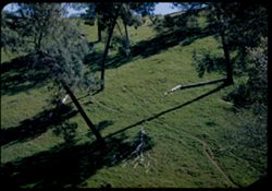
- 1252.38
- Persistent URL:
- http://purl.dlib.indiana.edu/iudl/archives/cushman/P05944
- Holding Location:
- Bloomington - University Archives
Wells Library E460
1320 E 10th St.
Bloomington, IN 47405
Contact at archives@indiana.edu, 812-855-1127
-
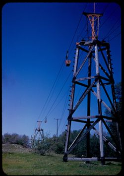
- Description:
- 50 f 10 - (error)
- Subject:
- Towers, Grasses, Trees, Tree limbs, Shrubs, and Conveying systems
- Series:
- 12-52
- Creator:
- Cushman, Charles W., 1896-1972
- Date Created:
- 1952-04-04
- Genre:
- Snapshots
- Frame Number:
- 37
- Street Address:
- California State Highway 49
- County:
- El Dorado
- Abstract:
- Overhead trolley south of Placerville on Cal. 49.
- Call Number:
- P05943
- City:
- Placerville
- Country:
- United States
- State/Province:
- California
- Alternate Identifier:
- 1252.37
- Persistent URL:
- http://purl.dlib.indiana.edu/iudl/archives/cushman/P05943
- Holding Location:
- Bloomington - University Archives
Wells Library E460
1320 E 10th St.
Bloomington, IN 47405
Contact at archives@indiana.edu, 812-855-1127
-
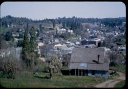
- Description:
- 25 f 9
- Subject:
- Buildings, Hills, Grasses, Trees, Houses, and Roads
- Series:
- 12-52
- Creator:
- Cushman, Charles W., 1896-1972
- Date Created:
- 1952-04-04
- Genre:
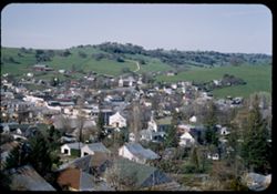
- Cityscape photographs
- Frame Number:
- 36
- County:
- El Dorado
- Abstract:
- Looking down on Placerville.
- Call Number:
- P05942
- City:
- Placerville
- Country:
- United States
- State/Province:
- California
- Alternate Identifier:
- 1252.36
- Persistent URL:
- http://purl.dlib.indiana.edu/iudl/archives/cushman/P05942
- Holding Location:
- Bloomington - University Archives
Wells Library E460
1320 E 10th St.
Bloomington, IN 47405
Contact at archives@indiana.edu, 812-855-1127
-
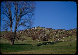
- Description:
- 25 f 10
- Subject:
- Rocks, Grasses, Trees, Boulders, Mountains, Shrubs, and Hills
- Series:
- 12-52
- Creator:
- Cushman, Charles W., 1896-1972
- Date Created:
- 1952-04-03
- Genre:
- Landscape photographs
- Frame Number:
- 35
- Street Address:
- California State Highway 49
- County:
- El Dorado and Placer
- Abstract:
- Rocks + brown shrubs on green mtn. Side = Auburn - Placerville Hwy 49.
- Call Number:
- P05941
- City:
- Placerville and Auburn
- Country:
- United States
- State/Province:
- California
- Alternate Identifier:
- 1252.35
- Persistent URL:
- http://purl.dlib.indiana.edu/iudl/archives/cushman/P05941
- Holding Location:
- Bloomington - University Archives
Wells Library E460
1320 E 10th St.
Bloomington, IN 47405
Contact at archives@indiana.edu, 812-855-1127
-
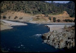
- Description:
- 25 f 9
- Subject:
- Rocks, Roads, Trees, American River (Calif.), Beaches, Rapids, Hills, Rivers, and School buses
- Series:
- 12-52
- Creator:
- Cushman, Charles W., 1896-1972
- Date Created:
- 1952-04-03
- Genre:
- Landscape photographs
- Frame Number:
- 34
- Street Address:
- California State Highway 49
- County:
- Placer
- Abstract:
- From bridge over North Fork American River above Auburn (on Hwy 49).
- Call Number:
- P05940
- City:
- Auburn
- Country:
- United States
- State/Province:
- California
- Alternate Identifier:
- 1252.34
- Persistent URL:
- http://purl.dlib.indiana.edu/iudl/archives/cushman/P05940
- Holding Location:
- Bloomington - University Archives
Wells Library E460
1320 E 10th St.
Bloomington, IN 47405
Contact at archives@indiana.edu, 812-855-1127
-
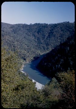
- Description:
- 25 f 8
- Subject:
- Canyons, Trees, American River (Calif.), and Rivers
- Series:
- 12-52
- Creator:
- Cushman, Charles W., 1896-1972
- Date Created:
- 1952-04-03
- Genre:
- Landscape photographs
- Frame Number:
- 33
- Street Address:
- California State Highway 49
- County:
- Placer
- Abstract:
- From Hwy Cal 49 - looking into canyon of American river near Auburn, Calif.
- Call Number:
- P05939
- City:
- Auburn
- Country:
- United States
- State/Province:
- California
- Alternate Identifier:
- 1252.33
- Persistent URL:
- http://purl.dlib.indiana.edu/iudl/archives/cushman/P05939
- Holding Location:
- Bloomington - University Archives
Wells Library E460
1320 E 10th St.
Bloomington, IN 47405
Contact at archives@indiana.edu, 812-855-1127
-
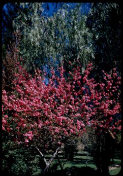
- Description:
- 25 f 11
- Subject:
- Parks, Land Park (Sacramento County, Calif.), Lawns, and Flowering trees
- Series:
- 12-52
- Creator:
- Cushman, Charles W., 1896-1972
- Date Created:
- 1952-04-03
- Genre:
- Identification photographs
- Frame Number:
- 32
- County:
- Sacramento
- Abstract:
- Land Pk., Sacramento.
- Call Number:
- P05938
- City:
- Sacramento
- Country:
- United States
- State/Province:
- California
- Alternate Identifier:
- 1252.32
- Persistent URL:
- http://purl.dlib.indiana.edu/iudl/archives/cushman/P05938
- Holding Location:
- Bloomington - University Archives
Wells Library E460
1320 E 10th St.
Bloomington, IN 47405
Contact at archives@indiana.edu, 812-855-1127
-
- Description:
- 25 f 9
- Subject:
- Ducks, Parks, Land Park (Sacramento County, Calif.), Shadows, Walkways, Lawns, Flowering trees, and Lakes & ponds
- Series:
- 12-52
- Creator:
- Cushman, Charles W., 1896-1972
- Date Created:
- 1952-04-03
- Genre:
- Identification photographs
- Frame Number:
- 31
- County:
- Sacramento
- Abstract:
- Land Pk., Sacramento.
- Call Number:
- P05937
- City:
- Sacramento
- Country:
- United States
- State/Province:
- California
- Alternate Identifier:
- 1252.31
- Persistent URL:
- http://purl.dlib.indiana.edu/iudl/archives/cushman/P05937
- Holding Location:
- Bloomington - University Archives
Wells Library E460
1320 E 10th St.
Bloomington, IN 47405
Contact at archives@indiana.edu, 812-855-1127
-
- Description:
- 25 f 8
- Subject:
- California State Capitol (Sacramento, Calif.), Cedar trees, Trees, Walkways, and Deodar cedar
- Series:
- 12-52
- Creator:
- Cushman, Charles W., 1896-1972
- Date Created:
- 1952-04-02
- Genre:
- Identification photographs
- Frame Number:
- 30
- County:
- Sacramento
- Abstract:
- Deodars on Capitol grounds.
- Call Number:
- P05936
- City:
- Sacramento
- Country:
- United States
- State/Province:
- California
- Alternate Identifier:
- 1252.30
- Persistent URL:
- http://purl.dlib.indiana.edu/iudl/archives/cushman/P05936
- Holding Location:
- Bloomington - University Archives
Wells Library E460
1320 E 10th St.
Bloomington, IN 47405
Contact at archives@indiana.edu, 812-855-1127
-
- Description:
- 25 f 9
- Subject:
- Deodar cedar, Flags, Drinking fountains, California State Capitol (Sacramento, Calif.), Lawns, Peristyles, Flagpoles, Domes, Palms, State flags, Colonnades, ...
- Series:
- 12-52
- Creator:
- Cushman, Charles W., 1896-1972
- Date Created:
- 1952-04-02
- Genre:
- Architectural photographs
- Frame Number:
- 29
- County:
- Sacramento
- Abstract:
- Capitol Dome - with palm fronds + Deodar branches.
- Call Number:
- P05935
- City:
- Sacramento
- Country:
- United States
- State/Province:
- California
- Physical Description:
- masked.
- Alternate Identifier:
- 1252.29
- Persistent URL:
- http://purl.dlib.indiana.edu/iudl/archives/cushman/P05935
- Holding Location:
- Bloomington - University Archives
Wells Library E460
1320 E 10th St.
Bloomington, IN 47405
Contact at archives@indiana.edu, 812-855-1127
-
- Description:
- 25 f 9
- Subject:
- State flags, Flags, Pilasters, Streets, California State Capitol (Sacramento, Calif.), Capitols, Peristyles, Flagpoles, Domes, Columns, Palms, Colonnades, an...
- Series:
- 12-52
- Creator:
- Cushman, Charles W., 1896-1972
- Date Created:
- 1952-04-02
- Genre:
- Architectural photographs
- Frame Number:
- 28
- County:
- Sacramento
- Abstract:
- Sacramento - State Capitol.
- Call Number:
- P05934
- City:
- Sacramento
- Country:
- United States
- State/Province:
- California
- Physical Description:
- masked.
- Alternate Identifier:
- 1252.28
- Persistent URL:
- http://purl.dlib.indiana.edu/iudl/archives/cushman/P05934
- Holding Location:
- Bloomington - University Archives
Wells Library E460
1320 E 10th St.
Bloomington, IN 47405
Contact at archives@indiana.edu, 812-855-1127
-
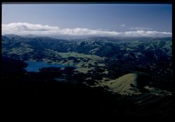
- Description:
- 25 f 5.6 Pola
- Subject:
- Lakes & ponds, Hills, Tamalpais, Mount (Calif.), Shadows, and Clouds
- Series:
- 12-52
- Creator:
- Cushman, Charles W., 1896-1972
- Date Created:
- 1952-03-30
- Genre:
- Landscape photographs
- Frame Number:
- 27
- County:
- Marin
- Abstract:
- Marin hills north of Tamalpais
- Call Number:
- P05933
- Country:
- United States
- State/Province:
- California
- Physical Description:
- Image was originally mounted in a glass enclosure. Before digitization, the image was removed and placed in a Wess Plastic, Inc. brand, 2" x 2", pl...
- Alternate Identifier:
- 1252.27
- Persistent URL:
- http://purl.dlib.indiana.edu/iudl/archives/cushman/P05933
- Holding Location:
- Bloomington - University Archives
Wells Library E460
1320 E 10th St.
Bloomington, IN 47405
Contact at archives@indiana.edu, 812-855-1127
-
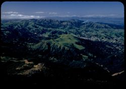
- Description:
- 25 f 6.3 Pola
- Subject:
- Tamalpais, Mount (Calif.) and Hills
- Series:
- 12-52
- Creator:
- Cushman, Charles W., 1896-1972
- Date Created:
- 1952-03-30
- Genre:
- Landscape photographs and Cityscape photographs
- Frame Number:
- 26
- County:
- Marin
- Abstract:
- Marin hills north of Tamalpais.
- Call Number:
- P05932
- Country:
- United States
- State/Province:
- California
- Alternate Identifier:
- 1252.26
- Persistent URL:
- http://purl.dlib.indiana.edu/iudl/archives/cushman/P05932
- Holding Location:
- Bloomington - University Archives
Wells Library E460
1320 E 10th St.
Bloomington, IN 47405
Contact at archives@indiana.edu, 812-855-1127
-
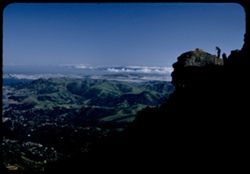
- Description:
- 25 f 6 Pola
- Subject:
- Bays (Bodies of water), Climbing, Cliffs, Mountaineering, Shadows, Mountains, Rock formations, Tamalpais, Mount (Calif.), Hills, People, and San Francisco Ba...
- Series:
- 12-52
- Creator:
- Cushman, Charles W., 1896-1972
- Date Created:
- 1952-03-30
- Genre:
- Landscape photographs and Cityscape photographs
- Frame Number:
- 25
- County:
- San Francisco
- Abstract:
- View past profile rock.
- Call Number:
- P05931
- Country:
- United States
- State/Province:
- California
- Alternate Identifier:
- 1252.25
- Persistent URL:
- http://purl.dlib.indiana.edu/iudl/archives/cushman/P05931
- Holding Location:
- Bloomington - University Archives
Wells Library E460
1320 E 10th St.
Bloomington, IN 47405
Contact at archives@indiana.edu, 812-855-1127
-
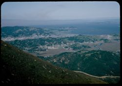
- Description:
- 25 f 8 Pola
- Subject:
- Bays (Bodies of water), Roads, Mountains, Tamalpais, Mount (Calif.), Hills, and San Francisco Bay (Calif.)
- Series:
- 12-52
- Creator:
- Cushman, Charles W., 1896-1972
- Date Created:
- 1952-03-30
- Genre:
- Landscape photographs and Cityscape photographs
- Frame Number:
- 23
- County:
- Marin
- Abstract:
- View N by E over San Rafael.
- Call Number:
- P05930
- City:
- San Rafael
- Country:
- United States
- State/Province:
- California
- Alternate Identifier:
- 1252.23
- Persistent URL:
- http://purl.dlib.indiana.edu/iudl/archives/cushman/P05930
- Holding Location:
- Bloomington - University Archives
Wells Library E460
1320 E 10th St.
Bloomington, IN 47405
Contact at archives@indiana.edu, 812-855-1127
-
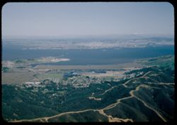
- Description:
- 25 f 8 Pola
- Subject:
- Bays (Bodies of water), Roads, Coastlines, Forests, Hills, San Francisco Bay (Calif.), and Tamalpais, Mount (Calif.)
- Series:
- 12-52
- Creator:
- Cushman, Charles W., 1896-1972
- Date Created:
- 1952-03-30
- Genre:
- Landscape photographs and Cityscape photographs
- Frame Number:
- 22
- County:
- Contra Costa
- Abstract:
- View toward Richmond.
- Call Number:
- P05929
- City:
- Richmond
- Country:
- United States
- State/Province:
- California
- Alternate Identifier:
- 1252.22
- Persistent URL:
- http://purl.dlib.indiana.edu/iudl/archives/cushman/P05929
- Holding Location:
- Bloomington - University Archives
Wells Library E460
1320 E 10th St.
Bloomington, IN 47405
Contact at archives@indiana.edu, 812-855-1127
-
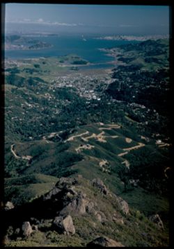
- Description:
- 25 f 6 Pola
- Subject:
- Rocks, Bays (Bodies of water), Roads, Boulders, Shrubs, Tamalpais, Mount (Calif.), Hills, San Francisco Bay (Calif.), and Rock formations
- Series:
- 12-52
- Creator:
- Cushman, Charles W., 1896-1972
- Date Created:
- 1952-03-30
- Genre:
- Landscape photographs and Cityscape photographs
- Frame Number:
- 21
- County:
- San Francisco
- Abstract:
- Down the mtn. side from outlook pt.
- Call Number:
- P05928
- City:
- San Francisco
- Country:
- United States
- State/Province:
- California
- Physical Description:
- Image was originally mounted in a glass enclosure. Before digitization, the image was removed and placed in a Wess Plastic, Inc. brand, 2" x 2", pl...
- Alternate Identifier:
- 1252.21
- Persistent URL:
- http://purl.dlib.indiana.edu/iudl/archives/cushman/P05928
- Holding Location:
- Bloomington - University Archives
Wells Library E460
1320 E 10th St.
Bloomington, IN 47405
Contact at archives@indiana.edu, 812-855-1127
-
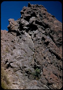
- Description:
- 25 f 9
- Subject:
- Rock formations, Tamalpais, Mount (Calif.), and Shrubs
- Series:
- 12-52
- Creator:
- Cushman, Charles W., 1896-1972
- Date Created:
- 1952-03-30
- Genre:
- Landscape photographs
- Frame Number:
- 20
- County:
- Marin
- Abstract:
- Close-up of 19 [Cinder-like rock atop Mt. Tamalpais.]
- Call Number:
- P05927
- Country:
- United States
- State/Province:
- California
- Alternate Identifier:
- 1252.20
- Persistent URL:
- http://purl.dlib.indiana.edu/iudl/archives/cushman/P05927
- Holding Location:
- Bloomington - University Archives
Wells Library E460
1320 E 10th St.
Bloomington, IN 47405
Contact at archives@indiana.edu, 812-855-1127
-
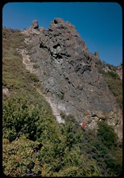
- Description:
- 25 f 9
- Subject:
- Hiking, Cliffs, People, Shrubs, Rock formations, and Tamalpais, Mount (Calif.)
- Series:
- 12-52
- Creator:
- Cushman, Charles W., 1896-1972
- Date Created:
- 1952-03-30
- Genre:
- Landscape photographs
- Frame Number:
- 19
- County:
- Marin
- Abstract:
- Cinder-like rock atop Mt. Tamalpais.
- Call Number:
- P05926
- Country:
- United States
- State/Province:
- California
- Alternate Identifier:
- 1252.19
- Persistent URL:
- http://purl.dlib.indiana.edu/iudl/archives/cushman/P05926
- Holding Location:
- Bloomington - University Archives
Wells Library E460
1320 E 10th St.
Bloomington, IN 47405
Contact at archives@indiana.edu, 812-855-1127
-
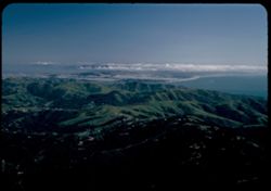
- Description:
- 25 f 6.3 Pola
- Subject:
- Bays (Bodies of water), Oceans, Fog, Trees, Coastlines, Pacific Ocean, Pacific Coast (Calif.), Tamalpais, Mount (Calif.), Hills, San Francisco Bay (Calif.), ...
- Series:
- 12-52
- Creator:
- Cushman, Charles W., 1896-1972
- Date Created:
- 1952-03-30
- Genre:
- Landscape photographs and Cityscape photographs
- Frame Number:
- 18
- County:
- Marin and San Francisco
- Abstract:
- Fog bank over SF.
- Call Number:
- P05925
- City:
- San Francisco
- Country:
- United States
- State/Province:
- California
- Alternate Identifier:
- 1252.18
- Persistent URL:
- http://purl.dlib.indiana.edu/iudl/archives/cushman/P05925
- Holding Location:
- Bloomington - University Archives
Wells Library E460
1320 E 10th St.
Bloomington, IN 47405
Contact at archives@indiana.edu, 812-855-1127
-
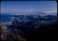
- Description:
- 25 f 6 Pola
- Subject:
- Bays (Bodies of water), Oceans, Coastlines, Pacific Ocean, Shrubs, Pacific Coast (Calif.), Tamalpais, Mount (Calif.), Hills, and San Francisco Bay (Calif.)
- Series:
- 12-52
- Creator:
- Cushman, Charles W., 1896-1972
- Date Created:
- 1952-03-30
- Genre:
- Landscape photographs and Cityscape photographs
- Frame Number:
- 17
- County:
- Marin and San Francisco
- Abstract:
- SF beyond Marin hills.
- Call Number:
- P05924
- City:
- San Francisco
- Country:
- United States
- State/Province:
- California
- Alternate Identifier:
- 1252.17
- Persistent URL:
- http://purl.dlib.indiana.edu/iudl/archives/cushman/P05924
- Holding Location:
- Bloomington - University Archives
Wells Library E460
1320 E 10th St.
Bloomington, IN 47405
Contact at archives@indiana.edu, 812-855-1127
-
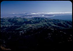
- Description:
- 25 f 6.3 Pola
- Subject:
- Hills, San Francisco Bay (Calif.), Pacific Ocean, Bays (Bodies of water), Pacific Coast (Calif.), Tamalpais, Mount (Calif.), Trees, Oceans, Coastlines, and C...
- Series:
- 12-52
- Creator:
- Cushman, Charles W., 1896-1972
- Date Created:
- 1952-03-30
- Genre:
- Landscape photographs and Cityscape photographs
- Frame Number:
- 16
- County:
- Marin and San Francisco
- Abstract:
- S.F. west end.
- Call Number:
- P05923
- City:
- San Francisco
- Country:
- United States
- State/Province:
- California
- Alternate Identifier:
- 1252.16
- Persistent URL:
- http://purl.dlib.indiana.edu/iudl/archives/cushman/P05923
- Holding Location:
- Bloomington - University Archives
Wells Library E460
1320 E 10th St.
Bloomington, IN 47405
Contact at archives@indiana.edu, 812-855-1127
-
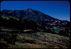
- Description:
- 25 f 6.3 Pola
- Subject:
- Wildflowers, Grasses, Roads, Trees, Mountains, Shrubs, Tamalpais, Mount (Calif.), Utility poles, and Houses
- Series:
- 12-52
- Creator:
- Cushman, Charles W., 1896-1972
- Date Created:
- 1952-03-30
- Genre:
- Landscape photographs
- Frame Number:
- 15
- County:
- Marin
- Abstract:
- Mt. Tamalpais from road above Mill Valley.
- Call Number:
- P05922
- City:
- Mill Valley
- Country:
- United States
- State/Province:
- California
- Alternate Identifier:
- 1252.15
- Persistent URL:
- http://purl.dlib.indiana.edu/iudl/archives/cushman/P05922
- Holding Location:
- Bloomington - University Archives
Wells Library E460
1320 E 10th St.
Bloomington, IN 47405
Contact at archives@indiana.edu, 812-855-1127
-

- Description:
- 25 f 6.3 Pola
- Subject:
- Bays (Bodies of water), Shrubs, Trees, Trails & paths, Grasses, and Wildflowers
- Series:
- 12-52
- Creator:
- Cushman, Charles W., 1896-1972
- Date Created:
- 1952-03-30
- Genre:
- Landscape photographs and Cityscape photographs
- Frame Number:
- 14
- Street Address:
- Mount Tamalpais Road
- County:
- Marin
- Abstract:
- View East toward Belvedere - from Mt. Tamalpais Rd. above Mill Valley.
- Call Number:
- P05921
- City:
- Belvedere and Mill Valley
- Country:
- United States
- State/Province:
- California
- Alternate Identifier:
- 1252.14
- Persistent URL:
- http://purl.dlib.indiana.edu/iudl/archives/cushman/P05921
- Holding Location:
- Bloomington - University Archives
Wells Library E460
1320 E 10th St.
Bloomington, IN 47405
Contact at archives@indiana.edu, 812-855-1127