
Search Constraints
You searched for:
Campus
IUB
Remove constraint Campus: IUB
Provenance
CIA Map Library
Remove constraint Provenance: CIA Map Library
Publisher
Генеральный штаб Красной Армии
Remove constraint Publisher: Генеральный штаб Красной Армии
« Previous |
1 - 20 of 94
|
Next »
Search Results
-
- Subject:
- Topical Subject: Maps, Topical Subject: Soviet Union, and Geographic Subject: Julfa
- Publisher:
- Генеральный штаб Красной Армии
- Language:
- Russian
- Date Created:
- 1940
- Identifier:
- VAC9619-000089
- Genre:
- Topographic Maps and Military Maps
- Geographic Location:
- Coordinates: 38.8333, 45.5, 39, 45.75
- Related URL:
- Download GeoTIFF: https://drive.google.com/open?id=1fZhMoeilfY5E-PsoYnAeUMHJQW6GUmXx and Catalog URL: http://iucat.iu.edu/catalog/5020131
- Abstract:
- Modern area represented: Julfa, Azerbaijan
- Call Number:
- G7000 s50 .S68 sheet J-38-44-A
- Caption:
- Не подлежит оглашению
- City:
- Джульфа (Dzhulfa)
- Copyright Holder:
- No Copyright - United States
- Country:
- Иран (Iran) and СССР (USSR)
- State/Province:
- Нахичеванская АССР (Nakhichevan Autonomous Soviet Socialist Republic)
- Physical Description:
- Scale: 1:50,000
- Persistent URL:
- http://purl.dlib.indiana.edu/iudl/images/VAC9619/VAC9619-000089
- Provenance:
- CIA Map Library
-
- Description:
- 1905
- Subject:
- Topical Subject: Maps, Topical Subject: Soviet Union, and Geographic Subject: Lazarevskoye
- Publisher:
- Генеральный штаб Красной Армии
- Language:
- Russian
- Date Created:
- 1942
- Identifier:
- VAC9619-000759
- Genre:
- Topographic Maps and Military Maps
- Geographic Location:
- Coordinates: 43.6667, 39, 44, 39.5
- Related URL:
- Catalog URL: https://iucat.iu.edu/catalog/5020129 and Download GeoTIFF: https://drive.google.com/open?id=1OcoSmUSM2ZO6HwjSl9T2sxJaHo8Fbzui
- Abstract:
- Modern area represented: Lazarevskoye, Krasnodar kray, Russia
- Call Number:
- G7000 s100 .S7 sheet K-37-7
- Caption:
- Для служебного пользования
- City:
- Лазаревская (Lazarevskoye)
- Copyright Holder:
- No Copyright - United States
- Country:
- СССР (USSR)
- State/Province:
- Краснодарская область (Krasnodar oblast) and РСФСР (RSFSR)
- Physical Description:
- Scale: 1:100,000
- Persistent URL:
- http://purl.dlib.indiana.edu/iudl/images/VAC9619/VAC9619-000759
- Provenance:
- CIA Map Library
-
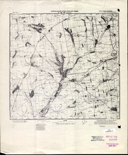
- Subject:
- Topical Subject: Maps, Geographic Subject: Aleksandriyskaya, and Topical Subject: Soviet Union
- Publisher:
- Генеральный штаб Красной Армии
- Language:
- Russian
- Identifier:
- VAC9619-000813
- Genre:
- Topographic Maps and Military Maps
- Related URL:
- Catalog URL: https://iucat.iu.edu/catalog/5020129
- Abstract:
- Modern area represented: Aleksandriyskaya, Dagestan republic, Russia
- Call Number:
- G7000 s100 .S7 sheet K-38-11
- Copyright Holder:
- No Copyright - United States
- Country:
- СССР (USSR)
- Physical Description:
- Scale: 1:100,000
- Persistent URL:
- http://purl.dlib.indiana.edu/iudl/images/VAC9619/VAC9619-000813
- Provenance:
- CIA Map Library
-
- Description:
- 1873
- Subject:
- Geographic Subject: Selyatyn, Topical Subject: Maps, and Topical Subject: Soviet Union
- Publisher:
- Генеральный штаб Красной Армии
- Language:
- Russian
- Date Created:
- 1939
- Identifier:
- VAC9619-001472
- Genre:
- Military Maps and Topographic Maps
- Geographic Location:
- Coordinates: 47.6667, 25, 48, 25.5
- Related URL:
- Download GeoTIFF: https://drive.google.com/open?id=1v6zIUxpzw2mb5AD7jE4-hVpFfWBpe8B8 and Catalog URL: https://iucat.iu.edu/catalog/5020129
- Abstract:
- Modern area represented: Selyatyn, Chernivtsi oblast, Ukraine
- Call Number:
- G7000 s100 .S7 sheet L-35-3
- Caption:
- Для служебного пользования
- City:
- Селетин (Selyatyn)
- Copyright Holder:
- No Copyright - United States
- Country:
- Румыния (Romania)
- State/Province:
- Украинская ССР (Ukrainian Soviet Socialist Republic) and Черновицкая область (Chernivtsi oblast)
- Physical Description:
- Scale: 1:100,000
- Persistent URL:
- http://purl.dlib.indiana.edu/iudl/images/VAC9619/VAC9619-001472
- Provenance:
- CIA Map Library
-
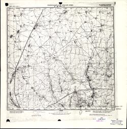
- Description:
- 1891
- Subject:
- Topical Subject: Soviet Union, Topical Subject: Maps, and Geographic Subject: Dragomireşti
- Publisher:
- Генеральный штаб Красной Армии
- Language:
- Russian
- Date Created:
- 1940
- Identifier:
- VAC9619-001755
- Genre:
- Military Maps and Topographic Maps
- Geographic Location:
- Coordinates: 46.3333, 27, 46.6667, 27.5
- Related URL:
- Download GeoTIFF: https://drive.google.com/file/d/1hCPO_hgwRlOoKYWPQdYYSitq_p-y_Ezx/view?usp=sharing and Catalog URL: https://iucat.iu.edu/catalog/5020129
- Abstract:
- Modern area represented: Dragomireşti, Vaslui county, Romania
- Call Number:
- G7000 s100 .S7 sheet L-35-55
- City:
- Драгомирешти (Dragomireşti)
- Copyright Holder:
- No Copyright - United States
- Country:
- Румыния (Romania)
- Physical Description:
- Scale: 1:100,000
- Persistent URL:
- http://purl.dlib.indiana.edu/iudl/images/VAC9619/VAC9619-001755
- Provenance:
- CIA Map Library
-
- Description:
- 1926
- Subject:
- Topical Subject: Maps, Geographic Subject: Tomakivka, and Topical Subject: Soviet Union
- Publisher:
- Генеральный штаб Красной Армии
- Language:
- Russian
- Date Created:
- 1941
- Identifier:
- VAC9619-001823
- Genre:
- Topographic Maps and Military Maps
- Geographic Location:
- Coordinates: 47.6667, 34.5, 48, 35
- Related URL:
- Download GeoTIFF: https://drive.google.com/file/d/14Nyu2PujbMSA_GYJjeQF3P2MPNH2zV-g/view?usp=sharing and Catalog URL: https://iucat.iu.edu/catalog/5020129
- Abstract:
- Modern area represented: Tomakivka, Dnipropetrovsk oblast, Ukraine
- Call Number:
- G7000 s100 .S7 sheet L-36-10
- Caption:
- Для служебного пользования
- City:
- Томаковка (Tomakivka)
- Copyright Holder:
- No Copyright - United States
- Country:
- СССР (USSR)
- State/Province:
- Запорожская область (Zaporizhia oblast) and Украинская ССР (Ukrainian Soviet Socialist Republic)
- Physical Description:
- Scale: 1:100,000
- Persistent URL:
- http://purl.dlib.indiana.edu/iudl/images/VAC9619/VAC9619-001823
- Provenance:
- CIA Map Library
-
- Description:
- 1895
- Subject:
- Geographic Subject: Republic of Crimea, Geographic Subject: Saki, Topical Subject: Soviet Union, and Topical Subject: Maps
- Publisher:
- Генеральный штаб Красной Армии
- Language:
- Russian
- Date Created:
- 1941
- Identifier:
- VAC9619-001956
- Genre:
- Topographic Maps and Military Maps
- Geographic Location:
- Coordinates: 45, 33.5, 45.3333, 34
- Related URL:
- Download GeoTIFF: https://drive.google.com/open?id=1KeZQMnq0svWW8sbbr2gRu_IXfdHE5Zod and Catalog URL: https://iucat.iu.edu/catalog/5020129
- Abstract:
- Modern area represented: Саки (Saki), Republic of Crimea, Ukraine
- Call Number:
- G7000 s100 .S7 sheet L-36-104
- Caption:
- Для cлужебного пользования
- City:
- Саки (Saki)
- Copyright Holder:
- No Copyright - United States
- Country:
- СССР (USSR)
- State/Province:
- РСФСР (RSFSR)
- Physical Description:
- Scale: 1:100,000
- Persistent URL:
- http://purl.dlib.indiana.edu/iudl/images/VAC9619/VAC9619-001956
- Provenance:
- CIA Map Library
-
- Description:
- 1894
- Subject:
- Topical Subject: Maps, Topical Subject: Soviet Union, Geographic Subject: Zuya, and Geographic Subject: Republic of Crimea
- Publisher:
- Генеральный штаб Красной Армии
- Language:
- Russian
- Date Created:
- 1941
- Identifier:
- VAC9619-001957
- Genre:
- Military Maps and Topographic Maps
- Geographic Location:
- Coordinates: 45, 34, 45.3333, 34.5
- Related URL:
- Catalog URL: https://iucat.iu.edu/catalog/5020129 and Download GeoTIFF: https://drive.google.com/open?id=1OnZgZa5AYScso5JZKHdHoMlUXdIKTLCN
- Abstract:
- Modern area represented: Зуя (Zuya), Republic of Crimea, Ukraine
- Call Number:
- G7000 s100 .S7 sheet L-36-105
- Caption:
- Для cлужебного пользования
- City:
- Зуя (Zuya)
- Copyright Holder:
- No Copyright - United States
- Country:
- СССР (USSR)
- State/Province:
- РСФСР (RSFSR) and Крымская АССР (Crimean Autonomous Soviet Socialist Republic)
- Physical Description:
- Scale: 1:100,000
- Persistent URL:
- http://purl.dlib.indiana.edu/iudl/images/VAC9619/VAC9619-001957
- Provenance:
- CIA Map Library
-
- Description:
- 1889
- Subject:
- Geographic Subject: Lenino, Geographic Subject: Republic of Crimea, Topical Subject: Maps, and Topical Subject: Soviet Union
- Publisher:
- Генеральный штаб Красной Армии
- Language:
- Russian
- Date Created:
- 1941
- Identifier:
- VAC9619-001961
- Genre:
- Military Maps and Topographic Maps
- Geographic Location:
- Coordinates: 45, 35.5, 45.3333, 36
- Related URL:
- Catalog URL: https://iucat.iu.edu/catalog/5020129 and Download GeoTIFF: https://drive.google.com/file/d/1F8w9d0KgUCxo4OSUz7aU9WcBWB-3VFWe/view?usp=sharing
- Abstract:
- Modern area represented: Ленино (Lenino), Republic of Crimea, Ukraine
- Call Number:
- G7000 s100 .S7 sheet L-36-108
- Caption:
- Для cлужебного пользования
- City:
- Семь Колодезей (Semʹ Kolodezeĭ)
- Copyright Holder:
- No Copyright - United States
- Country:
- СССР (USSR)
- State/Province:
- РСФСР (RSFSR) and Крымская АССР (Crimean Autonomous Soviet Socialist Republic)
- Physical Description:
- Scale: 1:100,000
- Persistent URL:
- http://purl.dlib.indiana.edu/iudl/images/VAC9619/VAC9619-001961
- Provenance:
- CIA Map Library
-
- Description:
- 1889
- Subject:
- Topical Subject: Maps, Topical Subject: Soviet Union, Geographic Subject: Republic of Crimea, and Geographic Subject: Lenino
- Publisher:
- Генеральный штаб Красной Армии
- Language:
- Russian
- Date Created:
- 1941
- Identifier:
- VAC9619-001960
- Genre:
- Topographic Maps and Military Maps
- Geographic Location:
- Coordinates: 45, 35.5, 45.3333, 36
- Related URL:
- Catalog URL: https://iucat.iu.edu/catalog/5020129 and Download GeoTIFF: https://drive.google.com/open?id=1qSuczLfm0jn5nGPeX25LeOWVuRiIlhhe
- Abstract:
- Modern area represented: Ленино (Lenino), Republic of Crimea, Ukraine
- Call Number:
- G7000 s100 .S7 sheet L-36-108
- Caption:
- Для cлужебного пользования
- City:
- Семь Колодезей (Semʹ Kolodezeĭ)
- Copyright Holder:
- No Copyright - United States
- Country:
- СССР (USSR)
- State/Province:
- РСФСР (RSFSR) and Крымская АССР (Crimean Autonomous Soviet Socialist Republic)
- Physical Description:
- Scale: 1:100,000
- Persistent URL:
- http://purl.dlib.indiana.edu/iudl/images/VAC9619/VAC9619-001960
- Provenance:
- CIA Map Library
-
- Description:
- 1927
- Subject:
- Geographic Subject: Zaporizhia, Topical Subject: Soviet Union, and Topical Subject: Maps
- Publisher:
- Генеральный штаб Красной Армии
- Language:
- Russian
- Date Created:
- 1941
- Identifier:
- VAC9619-001831
- Genre:
- Topographic Maps and Military Maps
- Geographic Location:
- Coordinates: 47.6667, 35, 48, 35.5
- Related URL:
- Download GeoTIFF: https://drive.google.com/open?id=16w7gAgD3waAsgFnUeqhZv9WmeLo6ztJn and Catalog URL: https://iucat.iu.edu/catalog/5020129
- Abstract:
- Modern area represented: Zaporizhia, Zaporizhia oblast, Ukraine
- Call Number:
- G7000 s100 .S7 sheet L-36-11
- Caption:
- Для служебного пользования
- City:
- Запорожье (Zaporizhia)
- Copyright Holder:
- No Copyright - United States
- Country:
- СССР (USSR)
- State/Province:
- Украинская ССР (Ukrainian Soviet Socialist Republic) and Запорожская область (Zaporizhia oblast)
- Physical Description:
- Scale: 1:100,000
- Persistent URL:
- http://purl.dlib.indiana.edu/iudl/images/VAC9619/VAC9619-001831
- Provenance:
- CIA Map Library
-
- Description:
- 1889
- Subject:
- Geographic Subject: Republic of Crimea, Geographic Subject: Bakhchisaray, Topical Subject: Maps, and Topical Subject: Soviet Union
- Publisher:
- Генеральный штаб Красной Армии
- Language:
- Russian
- Date Created:
- 1941
- Identifier:
- VAC9619-001962
- Genre:
- Topographic Maps and Military Maps
- Geographic Location:
- Coordinates: 44.6667, 33.5, 45, 34
- Related URL:
- Download GeoTIFF: https://drive.google.com/open?id=1DfDXkMyieH7JsBdvMuTRR8d3wYawQcd9 and Catalog URL: https://iucat.iu.edu/catalog/5020129
- Abstract:
- Modern area represented: Bakhchisaray (Bakhchisaray), Republic of Crimea, Ukraine
- Call Number:
- G7000 s100 .S7 sheet L-36-116
- Caption:
- Для cлужебного пользования
- City:
- Bakhchisaray (Bakhchisaray)
- Copyright Holder:
- No Copyright - United States
- Country:
- СССР (USSR)
- State/Province:
- РСФСР (RSFSR) and Крымская АССР (Crimean Autonomous Soviet Socialist Republic)
- Physical Description:
- Scale: 1:100,000
- Persistent URL:
- http://purl.dlib.indiana.edu/iudl/images/VAC9619/VAC9619-001962
- Provenance:
- CIA Map Library
-
- Description:
- 1889
- Subject:
- Topical Subject: Maps, Geographic Subject: Republic of Crimea, Topical Subject: Soviet Union, and Geographic Subject: Simferopol
- Publisher:
- Генеральный штаб Красной Армии
- Language:
- Russian
- Date Created:
- 1941
- Identifier:
- VAC9619-001963
- Genre:
- Topographic Maps and Military Maps
- Geographic Location:
- Coordinates: 44.6667, 34, 45, 34.5
- Related URL:
- Download GeoTIFF: https://drive.google.com/open?id=1TOUI0x_hdHUWzPPKcEX-0cHUegwFWhCx and Catalog URL: https://iucat.iu.edu/catalog/5020129
- Abstract:
- Modern area represented: Симферополь (Simferopol), Republic of Crimea, Ukraine
- Call Number:
- G7000 s100 .S7 sheet L-36-117
- Caption:
- Для cлужебного пользования
- City:
- Симферополь (Simferopol)
- Copyright Holder:
- No Copyright - United States
- Country:
- СССР (USSR)
- State/Province:
- Крымская АССР (Crimean Autonomous Soviet Socialist Republic) and РСФСР (RSFSR)
- Physical Description:
- Scale: 1:100,000
- Persistent URL:
- http://purl.dlib.indiana.edu/iudl/images/VAC9619/VAC9619-001963
- Provenance:
- CIA Map Library
-
- Description:
- 1893
- Subject:
- Topical Subject: Maps, Geographic Subject: Republic of Crimea, Topical Subject: Soviet Union, and Geographic Subject: Sudak
- Publisher:
- Генеральный штаб Красной Армии
- Language:
- Russian
- Date Created:
- 1941
- Identifier:
- VAC9619-001965
- Genre:
- Military Maps and Topographic Maps
- Geographic Location:
- Coordinates: 44.6667, 34.5, 45, 35
- Related URL:
- Catalog URL: https://iucat.iu.edu/catalog/5020129 and Download GeoTIFF: https://drive.google.com/open?id=1GhztGrCrZpnhgPiIlhQl9-H8NXi_gHr3
- Abstract:
- Modern area represented: Sudak, Republic of Crimea, Ukraine
- Call Number:
- G7000 s100 .S7 sheet L-36-118
- Caption:
- Для служебного пользования
- City:
- Судак (Sudak)
- Copyright Holder:
- No Copyright - United States
- Country:
- СССР (USSR)
- State/Province:
- Крымская АССР (Crimean Autonomous Soviet Socialist Republic) and РСФСР (RSFSR)
- Physical Description:
- Scale: 1:100,000
- Persistent URL:
- http://purl.dlib.indiana.edu/iudl/images/VAC9619/VAC9619-001965
- Provenance:
- CIA Map Library
-

- Description:
- 1939
- Subject:
- Topical Subject: Soviet Union, Geographic Subject: Komyshuvakha, and Topical Subject: Maps
- Publisher:
- Генеральный штаб Красной Армии
- Language:
- Russian
- Date Created:
- 1941
- Identifier:
- VAC9619-001844
- Genre:
- Military Maps and Topographic Maps
- Geographic Location:
- Coordinates: 47.6667, 35.5, 48, 36
- Related URL:
- Download GeoTIFF: https://drive.google.com/open?id=1IiavgxI6IZ79dkMzQI3jHmPsU86TTxOH and Catalog URL: https://iucat.iu.edu/catalog/5020129
- Abstract:
- Modern area represented: Komyshuvakha, Zaporizhia oblast, Ukraine
- Call Number:
- G7000 s100 .S7 sheet L-36-12
- Caption:
- Для служебного пользования
- City:
- Камышуваха (Komyshuvakha)
- Copyright Holder:
- No Copyright - United States
- Country:
- СССР (USSR)
- State/Province:
- Запорожская область (Zaporizhia oblast) and Украинская ССР (Ukrainian Soviet Socialist Republic)
- Physical Description:
- Scale: 1:100,000
- Persistent URL:
- http://purl.dlib.indiana.edu/iudl/images/VAC9619/VAC9619-001844
- Provenance:
- CIA Map Library
-
- Description:
- 1886
- Subject:
- Topical Subject: Soviet Union, Geographic Subject: Republic of Crimea, Geographic Subject: Kozacha Bukhta, and Topical Subject: Maps
- Publisher:
- Генеральный штаб Красной Армии
- Language:
- Russian
- Date Created:
- 1941
- Identifier:
- VAC9619-001966
- Genre:
- Military Maps and Topographic Maps
- Geographic Location:
- Coordinates: 44.3333, 33, 44.6667, 33.5
- Related URL:
- Catalog URL: https://iucat.iu.edu/catalog/5020129 and Download GeoTIFF: https://drive.google.com/open?id=1rTxCetecx0VLFlLfe6F9Oq1Ke8pfHb3y
- Abstract:
- Modern area represented: Козача Бухта (Kozacha Bukhta), Republic of Crimea, Ukraine
- Call Number:
- G7000 s100 .S7 sheet L-36-127
- Caption:
- Для cлужебного пользования
- City:
- Бух. Казачья (Bukh. Kazachʹya)
- Copyright Holder:
- No Copyright - United States
- Country:
- СССР (USSR)
- State/Province:
- РСФСР (RSFSR) and Крымская АССР (Crimean Autonomous Soviet Socialist Republic)
- Physical Description:
- Scale: 1:100,000
- Persistent URL:
- http://purl.dlib.indiana.edu/iudl/images/VAC9619/VAC9619-001966
- Provenance:
- CIA Map Library
-
- Description:
- 1886
- Subject:
- Geographic Subject: Republic of Crimea, Topical Subject: Soviet Union, Topical Subject: Maps, and Geographic Subject: Sevastopolʹ
- Publisher:
- Генеральный штаб Красной Армии
- Language:
- Russian
- Date Created:
- 1941
- Identifier:
- VAC9619-001967
- Genre:
- Topographic Maps and Military Maps
- Geographic Location:
- Coordinates: 44.3333, 33.5, 44.6667, 34
- Related URL:
- Catalog URL: https://iucat.iu.edu/catalog/5020129 and Download GeoTIFF: https://drive.google.com/open?id=19Qph3otPZ3oxM7TayXAtAFPDKXxzx8mM
- Abstract:
- Modern area represented: Севастополь (Sevastopolʹ), Republic of Crimea, Ukraine
- Call Number:
- G7000 s100 .S7 sheet L-36-128
- Caption:
- Для cлужебного пользования
- City:
- Севастополь (Sevastopolʹ)
- Copyright Holder:
- No Copyright - United States
- Country:
- СССР (USSR)
- State/Province:
- Крымская АССР (Crimean Autonomous Soviet Socialist Republic) and РСФСР (RSFSR)
- Physical Description:
- Scale: 1:100,000
- Persistent URL:
- http://purl.dlib.indiana.edu/iudl/images/VAC9619/VAC9619-001967
- Provenance:
- CIA Map Library
-
- Description:
- 1889
- Subject:
- Topical Subject: Soviet Union, Geographic Subject: Yalta, Topical Subject: Maps, and Geographic Subject: Republic of Crimea
- Publisher:
- Генеральный штаб Красной Армии
- Language:
- Russian
- Date Created:
- 1941
- Identifier:
- VAC9619-001968
- Genre:
- Military Maps and Topographic Maps
- Geographic Location:
- Coordinates: 44.3333, 34, 44.6667, 34.5
- Related URL:
- Download GeoTIFF: https://drive.google.com/open?id=1bqnvue1x6vK7NQBgS7rVUAY7TfqiMxJ1 and Catalog URL: https://iucat.iu.edu/catalog/5020129
- Abstract:
- Modern area represented: Ялта (Yalta), Republic of Crimea, Ukraine
- Call Number:
- G7000 s100 .S7 sheet L-36-129
- Caption:
- Для cлужебного пользования
- City:
- Ялта (Yalta)
- Copyright Holder:
- No Copyright - United States
- Country:
- СССР (USSR)
- State/Province:
- РСФСР (RSFSR) and Крымская АССР (Crimean Autonomous Soviet Socialist Republic)
- Physical Description:
- Scale: 1:100,000
- Persistent URL:
- http://purl.dlib.indiana.edu/iudl/images/VAC9619/VAC9619-001968
- Provenance:
- CIA Map Library
-
- Description:
- 1928
- Subject:
- Geographic Subject: Voznesensk, Topical Subject: Maps, and Topical Subject: Soviet Union
- Publisher:
- Генеральный штаб Красной Армии
- Language:
- Russian
- Date Created:
- 1941
- Identifier:
- VAC9619-001853
- Genre:
- Topographic Maps and Military Maps
- Geographic Location:
- Coordinates: 47.3333, 31, 47.6667, 31.5
- Related URL:
- Catalog URL: https://iucat.iu.edu/catalog/5020129 and Download GeoTIFF: https://drive.google.com/open?id=1bR3CKUW57AtZTkAsFZhGcwe6LzRifVDw
- Abstract:
- Modern area represented: Voznesensk, Mykolaiv oblast, Ukraine
- Call Number:
- G7000 s100 .S7 sheet L-36-15
- Caption:
- Для служебного пользования
- City:
- Вознесенск (Voznesensk)
- Copyright Holder:
- No Copyright - United States
- Country:
- СССР (USSR)
- State/Province:
- Украинская ССР (Ukrainian Soviet Socialist Republic)
- Physical Description:
- Scale: 1:100,000
- Persistent URL:
- http://purl.dlib.indiana.edu/iudl/images/VAC9619/VAC9619-001853
- Provenance:
- CIA Map Library
-
- Description:
- 1926
- Subject:
- Topical Subject: Soviet Union, Topical Subject: Maps, and Geographic Subject: Nikopol
- Publisher:
- Генеральный штаб Красной Армии
- Language:
- Russian
- Date Created:
- 1941
- Identifier:
- VAC9619-001867
- Genre:
- Military Maps and Topographic Maps
- Geographic Location:
- Coordinates: 47.3333, 34, 47.6667, 34.5
- Related URL:
- Download GeoTIFF: https://drive.google.com/open?id=1255dfmhEQnsVoMASiJgE0Wqbhh4ks-Bt and Catalog URL: https://iucat.iu.edu/catalog/5020129
- Abstract:
- Modern area represented: Nikopol, Dnipropetrovsk, Ukraine
- Call Number:
- G7000 s100 .S7 sheet L-36-21
- Caption:
- Для служебного пользования
- City:
- Никополь (Nikopol)
- Copyright Holder:
- No Copyright - United States
- Country:
- СССР (USSR)
- State/Province:
- Днепропетровская область (Dnipropetrovsk oblast) and Украинская ССР (Ukrainian Soviet Socialist Republic)
- Physical Description:
- Scale: 1:100,000
- Persistent URL:
- http://purl.dlib.indiana.edu/iudl/images/VAC9619/VAC9619-001867
- Provenance:
- CIA Map Library
