
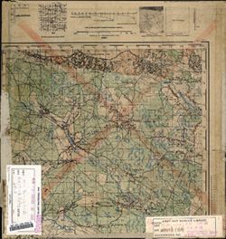
Search Constraints
You searched for:
Campus
IUB
Remove constraint Campus: IUB
Provenance
DMA Topographic Center, Army Map Service Library, OMAHA, Library of Congress Geography & Map Division
Remove constraint Provenance: DMA Topographic Center, Army Map Service Library, OMAHA, Library of Congress Geography & Map Division
« Previous |
1 - 50 of 904
|
Next »
Search Results
-
- Subject:
- Geographic Subject: Błażowa, Topical Subject: Soviet Union, and Topical Subject: Maps
- Publisher:
- Генеральный штаб Красной Армии
- Language:
- Russian
- Date Created:
- 1943
- Identifier:
- VAC9619-000182
- Genre:
- Military Maps and Topographic Maps
- Geographic Location:
- Coordinates: 49.8333, 22, 50, 22.25
- Related URL:
- Download GeoTIFF: https://drive.google.com/open?id=182kuHggLU1gE86FjxDeGbiYTSiIYnqKb and Catalog URL: http://iucat.iu.edu/catalog/5020131
- Abstract:
- Modern area represented: Błażowa, Poland
- Call Number:
- G7000 s50 .S68 sheet M-34-81-A
- City:
- Блажова (Błażowa)
- Copyright Holder:
- No Copyright - United States
- Country:
- Польша (Poland)
- Physical Description:
- Scale: 1:50,000
- Persistent URL:
- http://purl.dlib.indiana.edu/iudl/images/VAC9619/VAC9619-000182
- Provenance:
- DMA Topographic Center, Army Map Service Library, OMAHA, Library of Congress Geography & Map Division
-
- Description:
- 1940
- Subject:
- Geographic Subject: Lypivka, Topical Subject: Soviet Union, and Topical Subject: Maps
- Publisher:
- Генеральный штаб Красной Армии
- Language:
- Russian
- Date Created:
- 1943
- Identifier:
- VAC9619-000861
- Genre:
- Topographic Maps and Military Maps
- Geographic Location:
- Coordinates: 49.5, 24.5, 49.6667, 24.75
- Related URL:
- Catalog URL: http://iucat.iu.edu/catalog/5020131 and Download GeoTIFF: https://drive.google.com/open?id=1ej6f12IV_QxoID6Ct29cAOhFOBjx25jZ
- Abstract:
- Modern area represented: Lypivka, Ivano-Frankivsk oblast, Ukraine
- Call Number:
- G7000 s50 .S68 sheet M-35-86-A
- Caption:
- Для служебного пользования
- City:
- Фирлеюв (Firlejów)
- Copyright Holder:
- No Copyright - United States
- Country:
- СССР (USSR)
- State/Province:
- Украинская ССР (Ukrainian Soviet Socialist Republic), Львовская область (Lviv oblast), and Станиславская область (Stanislav oblast)
- Physical Description:
- Scale: 1:50,000
- Persistent URL:
- http://purl.dlib.indiana.edu/iudl/images/VAC9619/VAC9619-000861
- Provenance:
- DMA Topographic Center, Army Map Service Library, OMAHA, Library of Congress Geography & Map Division
-
- Description:
- 1940
- Subject:
- Geographic Subject: Топорів (Toporiv), Topical Subject: Soviet Union, and Topical Subject: Maps
- Publisher:
- Генеральный штаб Красной Армии
- Language:
- Russian
- Date Created:
- 1943
- Identifier:
- VAC9619-000232
- Genre:
- Military Maps and Topographic Maps
- Geographic Location:
- Coordinates: 50, 24.5, 50.167, 24.75
- Related URL:
- Catalog URL: http://iucat.iu.edu/catalog/5020131 and Download GeoTIFF: https://drive.google.com/open?id=11_H4F-_oZ1qMdG-z0p50WUkSaNk8GuQG
- Abstract:
- Modern area represented: Топорів (Toporiv), Lviv Oblast, Ukraine
- Call Number:
- G7000 s50 .S68 sheet M-35-62-C
- Caption:
- Для служебного пользования
- City:
- Топорув (Toporów)
- Copyright Holder:
- No Copyright - United States
- Country:
- СССР (USSR)
- State/Province:
- Львовская область (Lviv oblast) and Украинская ССР (Ukrainian Soviet Socialist Republic)
- Physical Description:
- Scale: 1:50,000
- Persistent URL:
- http://purl.dlib.indiana.edu/iudl/images/VAC9619/VAC9619-000232
- Provenance:
- DMA Topographic Center, Army Map Service Library, OMAHA, Library of Congress Geography & Map Division
-
- Description:
- 1940
- Subject:
- Geographic Subject: Зборів (Zboriv), Topical Subject: Soviet Union, and Topical Subject: Maps
- Publisher:
- Генеральный штаб Красной Армии
- Language:
- Russian
- Date Created:
- 1943
- Identifier:
- VAC9619-000865
- Genre:
- Topographic Maps and Military Maps
- Geographic Location:
- Coordinates: 49.5, 25, 49.6667, 25.25
- Related URL:
- Download GeoTIFF: https://drive.google.com/open?id=13fD1e7tHpUMyXj4TivXqIviF7MYQzEX_ and Catalog URL: http://iucat.iu.edu/catalog/5020131
- Abstract:
- Modern area represented: Зборів (Zboriv), Ternopil Oblast, Ukraine
- Call Number:
- G7000 s50 .S68 sheet M-35-87-A
- Caption:
- Для служебного пользования
- City:
- Зборов (Zborov)
- Copyright Holder:
- No Copyright - United States
- Country:
- СССР (USSR)
- State/Province:
- Тарнопольская область (Tarnopolskaya oblast) and Украинская ССР (Ukrainian Soviet Socialist Republic)
- Physical Description:
- Scale: 1:50,000
- Persistent URL:
- http://purl.dlib.indiana.edu/iudl/images/VAC9619/VAC9619-000865
- Provenance:
- DMA Topographic Center, Army Map Service Library, OMAHA, Library of Congress Geography & Map Division
-
- Description:
- 1940
- Subject:
- Topical Subject: Soviet Union, Geographic Subject: Козова (Kozova), and Topical Subject: Maps
- Publisher:
- Генеральный штаб Красной Армии
- Language:
- Russian
- Date Created:
- 1943
- Identifier:
- VAC9619-000868
- Genre:
- Military Maps and Topographic Maps
- Geographic Location:
- Coordinates: 49.3333, 25, 49.5, 25.25
- Related URL:
- Catalog URL: http://iucat.iu.edu/catalog/5020131 and Download GeoTIFF: https://drive.google.com/open?id=1skCxneunMNXcHWHSDwwBXT4FAeQfONAf
- Abstract:
- Modern area represented: Козова (Kozova), Ternopil Oblast, Ukraine
- Call Number:
- G7000 s50 .S68 sheet M-35-87-C
- Caption:
- Для служебного пользования
- City:
- Козово (Kozovo)
- Copyright Holder:
- No Copyright - United States
- Country:
- СССР (USSR)
- State/Province:
- Украинская ССР (Ukrainian Soviet Socialist Republic) and Тарнопольская область (Tarnopolskaya oblast)
- Physical Description:
- Scale: 1:50,000
- Persistent URL:
- http://purl.dlib.indiana.edu/iudl/images/VAC9619/VAC9619-000868
- Provenance:
- DMA Topographic Center, Army Map Service Library, OMAHA, Library of Congress Geography & Map Division
-

- Subject:
- Topical Subject: Maps, Geographic Subject: Rzepiennik Biskupi, and Topical Subject: Soviet Union
- Publisher:
- Генеральный штаб Красной Армии
- Language:
- Russian
- Date Created:
- 1943
- Identifier:
- VAC9619-000176
- Genre:
- Topographic Maps and Military Maps
- Geographic Location:
- Coordinates: 49.6667, 21, 49.8333, 21.25
- Related URL:
- Download GeoTIFF: https://drive.google.com/open?id=1x-cowPv8k6V4uHcs-gvCEMWJId1wYPNp and Catalog URL: http://iucat.iu.edu/catalog/5020131
- Abstract:
- Modern area represented: Rzepiennik Biskupi, Poland
- Call Number:
- G7000 s50 .S68 sheet M-34-79-C
- City:
- Жепенник (Rzepiennik)
- Copyright Holder:
- No Copyright - United States
- Country:
- Польша (Poland)
- Physical Description:
- Scale: 1:50,000
- Persistent URL:
- http://purl.dlib.indiana.edu/iudl/images/VAC9619/VAC9619-000176
- Provenance:
- DMA Topographic Center, Army Map Service Library, OMAHA, Library of Congress Geography & Map Division
-
- Description:
- 1940
- Subject:
- Topical Subject: Soviet Union, Geographic Subject: Бережани (Berezhany), and Topical Subject: Maps
- Publisher:
- Генеральный штаб Красной Армии
- Language:
- Russian
- Date Created:
- 1943
- Identifier:
- VAC9619-000864
- Genre:
- Military Maps and Topographic Maps
- Geographic Location:
- Coordinates: 49.3333, 24.75, 49.5, 25
- Related URL:
- Download GeoTIFF: https://drive.google.com/open?id=1bDJJmHQrRJaA1IcVeFRn6SdNn70r1-YT and Catalog URL: http://iucat.iu.edu/catalog/5020131
- Abstract:
- Modern area represented: Бережани (Berezhany), Ternopil oblast, Ukraine
- Call Number:
- G7000 s50 .S68 sheet M-35-85-D
- Caption:
- Для служебного пользования
- City:
- Бережаны (Berezhany)
- Copyright Holder:
- No Copyright - United States
- Country:
- СССР (USSR)
- State/Province:
- Тарнопольская область (Tarnopolskaya oblast), Украинская ССР (Ukrainian Soviet Socialist Republic), and Станиславская область (Stanislav oblast)
- Physical Description:
- Scale: 1:50,000
- Persistent URL:
- http://purl.dlib.indiana.edu/iudl/images/VAC9619/VAC9619-000864
- Provenance:
- DMA Topographic Center, Army Map Service Library, OMAHA, Library of Congress Geography & Map Division
-
- Description:
- 1940
- Subject:
- Topical Subject: Soviet Union, Geographic Subject: Магерів (Maheriv), and Topical Subject: Maps
- Publisher:
- Генеральный штаб Красной Армии
- Language:
- Russian
- Date Created:
- 1943
- Identifier:
- VAC9619-000175
- Genre:
- Military Maps and Topographic Maps
- Geographic Location:
- Coordinates: 50, 23.5, 50.1667, 23.75
- Related URL:
- Catalog URL: http://iucat.iu.edu/catalog/5020131 and Download GeoTIFF: https://drive.google.com/open?id=1K_LqDFGIDwl-vZiviwCS58MrP1-rg-er
- Abstract:
- Modern area represented: Магерів (Maheriv), Lviv oblast, Ukraine
- Call Number:
- G7000 s50 .S68 sheet M-34-72-C
- Caption:
- Для служебного пользования
- City:
- Магерув (Mageruv)
- Copyright Holder:
- No Copyright - United States
- Country:
- СССР (USSR)
- State/Province:
- Украинская ССР (Ukrainian Soviet Socialist Republic) and Львовская область (Lviv oblast)
- Physical Description:
- Scale: 1:50,000
- Persistent URL:
- http://purl.dlib.indiana.edu/iudl/images/VAC9619/VAC9619-000175
- Provenance:
- DMA Topographic Center, Army Map Service Library, OMAHA, Library of Congress Geography & Map Division
-
- Description:
- 1940
- Subject:
- Topical Subject: Maps, Topical Subject: Soviet Union, and Geographic Subject: Рогатин (Rohatyn)
- Publisher:
- Генеральный штаб Красной Армии
- Language:
- Russian
- Date Created:
- 1943
- Identifier:
- VAC9619-000863
- Genre:
- Topographic Maps and Military Maps
- Geographic Location:
- Coordinates: 49.3333, 24.5, 49.5, 24.75
- Related URL:
- Catalog URL: http://iucat.iu.edu/catalog/5020131 and Download GeoTIFF: https://drive.google.com/open?id=17mxtNljaUHm_unwMstjzF0DMOb7y5x0_
- Abstract:
- Modern area represented: Рогатин (Rohatyn), Ivano-Frankivsk Oblast, Ukraine
- Call Number:
- G7000 s50 .S68 sheet M-35-85-C
- Caption:
- Для служебного пользования
- City:
- Рогатин (Rogatin)
- Copyright Holder:
- No Copyright - United States
- Country:
- СССР (USSR)
- State/Province:
- Украинская ССР (Ukrainian Soviet Socialist Republic), Станиславская область (Stanislav oblast), Львовская область (Lviv oblast), and Тарнопольская область (T...
- Physical Description:
- Scale: 1:50,000
- Persistent URL:
- http://purl.dlib.indiana.edu/iudl/images/VAC9619/VAC9619-000863
- Provenance:
- DMA Topographic Center, Army Map Service Library, OMAHA, Library of Congress Geography & Map Division
-
- Description:
- 1940
- Subject:
- Geographic Subject: Тернопіль (Ternopil'), Topical Subject: Soviet Union, and Topical Subject: Maps
- Publisher:
- Генеральный штаб Красной Армии
- Language:
- Russian
- Date Created:
- 1943
- Identifier:
- VAC9619-000869
- Genre:
- Topographic Maps and Military Maps
- Geographic Location:
- Coordinates: 49.5, 25.5, 49.6667, 25.75
- Related URL:
- Download GeoTIFF: https://drive.google.com/open?id=1b59BaJ01jjxJDQSasEyKkGWROlwEXjwN and Catalog URL: http://iucat.iu.edu/catalog/5020131
- Abstract:
- Modern area represented: Тернопіль (Ternopil'), Ternopil Oblast, Ukraine
- Call Number:
- G7000 s50 .S68 sheet M-35-88-A
- Caption:
- Для служебного пользования
- City:
- Тарнополь (Tarnopol')
- Copyright Holder:
- No Copyright - United States
- Country:
- СССР (USSR)
- State/Province:
- Тарнопольская область (Tarnopolskaya oblast) and Украинская ССР (Ukrainian Soviet Socialist Republic)
- Physical Description:
- Scale: 1:50,000
- Persistent URL:
- http://purl.dlib.indiana.edu/iudl/images/VAC9619/VAC9619-000869
- Provenance:
- DMA Topographic Center, Army Map Service Library, OMAHA, Library of Congress Geography & Map Division
-
- Description:
- 1940
- Subject:
- Geographic Subject: Drohobych, Topical Subject: Maps, and Topical Subject: Soviet Union
- Publisher:
- Генеральный штаб Красной Армии
- Language:
- Russian
- Date Created:
- 1943
- Identifier:
- VAC9619-000188
- Genre:
- Military Maps and Topographic Maps
- Geographic Location:
- Coordinates: 49.3333, 23.5, 49.5, 23.75
- Related URL:
- Download GeoTIFF: https://drive.google.com/open?id=1MEqHst-PaDcmUBcopuEIqbJT1fLMiZ5i and Catalog URL: http://iucat.iu.edu/catalog/5020131
- Abstract:
- Modern area represented: Drohobych, Ukraine
- Call Number:
- G7000 s50 .S68 and zsheet M-34-96-C
- Caption:
- Для служебного пользования
- City:
- Дрогобыч (Drohobych)
- Copyright Holder:
- No Copyright - United States
- Country:
- СССР (USSR)
- State/Province:
- Дрогобычская область (Drohobych oblast) and Украинская ССР (Ukrainian Soviet Socialist Republic)
- Physical Description:
- Scale: 1:50,000
- Persistent URL:
- http://purl.dlib.indiana.edu/iudl/images/VAC9619/VAC9619-000188
- Provenance:
- DMA Topographic Center, Army Map Service Library, OMAHA, Library of Congress Geography & Map Division
-
- Description:
- 1940
- Subject:
- Geographic Subject: Богородчани (Bohorodchany), Topical Subject: Soviet Union, and Topical Subject: Maps
- Publisher:
- Генеральный штаб Красной Армии
- Language:
- Russian
- Date Created:
- 1943
- Identifier:
- VAC9619-000876
- Genre:
- Topographic Maps and Military Maps
- Geographic Location:
- Coordinates: 48.6667, 24.5, 48.8333, 24.75
- Related URL:
- Catalog URL: http://iucat.iu.edu/catalog/5020131 and Download GeoTIFF: https://drive.google.com/open?id=1POvzPGrgZOgvyq8sGq5xqB5nySWaNTtC
- Abstract:
- Modern area represented: Богородчани (Bohorodchany), Ivano-Frankivsk Oblast, Ukraine
- Call Number:
- G7000 s50 .S68 sheet M-35-110-C
- Caption:
- Captured map and Для служебного пользования
- City:
- Богородчаны (Bogorodchany)
- Copyright Holder:
- No Copyright - United States
- Country:
- СССР (USSR)
- State/Province:
- Украинская ССР (Ukrainian Soviet Socialist Republic) and Станиславская область (Stanislav oblast)
- Physical Description:
- Scale: 1:50,000
- Persistent URL:
- http://purl.dlib.indiana.edu/iudl/images/VAC9619/VAC9619-000876
- Provenance:
- DMA Topographic Center, Army Map Service Library, OMAHA, Library of Congress Geography & Map Division
-
- Subject:
- Geographic Subject: Radymno, Topical Subject: Maps, and Topical Subject: Soviet Union
- Publisher:
- Генеральный штаб Красной Армии
- Language:
- Russian
- Date Created:
- 1943
- Identifier:
- VAC9619-000186
- Genre:
- Topographic Maps and Military Maps
- Geographic Location:
- Coordinates: 49.8333, 22.75, 50, 23
- Related URL:
- Download GeoTIFF: https://drive.google.com/open?id=1pqBU3q09-3jEad3cJnm_hpV3oPYNXXhm and Catalog URL: http://iucat.iu.edu/catalog/5020131
- Abstract:
- Modern area represented: Radymno, Poland
- Call Number:
- G7000 s50 .S68 sheet M-34-82-B
- Caption:
- Для служебного пользования
- City:
- Радымно (Radymno)
- Copyright Holder:
- No Copyright - United States
- Country:
- СССР (USSR) and Польша (Poland)
- State/Province:
- Украинская ССР (Ukrainian Soviet Socialist Republic), Дрогобычская область (Drohobych oblast), and Львовская область (Lviv oblast)
- Physical Description:
- Scale: 1:50,000
- Persistent URL:
- http://purl.dlib.indiana.edu/iudl/images/VAC9619/VAC9619-000186
- Provenance:
- DMA Topographic Center, Army Map Service Library, OMAHA, Library of Congress Geography & Map Division
-
- Description:
- 1941
- Subject:
- Topical Subject: Maps, Topical Subject: Soviet Union, and Geographic Subject: Zachepylivka
- Publisher:
- Генеральный штаб Красной Армии
- Language:
- Russian
- Date Created:
- 1942
- Identifier:
- VAC9619-001083
- Genre:
- Topographic Maps and Military Maps
- Geographic Location:
- Coordinates: 49.167, 35, 49.333, 35.25
- Related URL:
- Download GeoTIFF: https://drive.google.com/open?id=1gD8DWOnnelvXp4qj3lPQ_vYPkk8dUxa_ and Catalog URL: http://iucat.iu.edu/catalog/5020131
- Abstract:
- Modern area represented: Zachepylivka, Kharkiv oblast, Ukraine
- Call Number:
- G7000 s50 .S68 М-36-107-А
- Caption:
- Для служебного пользования
- City:
- Зачепиловка (Zachepylivka)
- Copyright Holder:
- No Copyright - United States
- Country:
- СССР (USSR)
- State/Province:
- Днепропетровская область (Dnipropetrovsk oblast), Украинская ССР (Ukrainian Soviet Socialist Republic), Харьковская область (Kharkiv oblast), and Полтавская ...
- Physical Description:
- Scale: 1:50,000
- Persistent URL:
- http://purl.dlib.indiana.edu/iudl/images/VAC9619/VAC9619-001083
- Provenance:
- DMA Topographic Center, Army Map Service Library, OMAHA, Library of Congress Geography & Map Division
-
- Subject:
- Topical Subject: Soviet Union, Topical Subject: Maps, and Geographic Subject: Melykhivka
- Publisher:
- Генеральный штаб Красной Армии
- Language:
- Russian
- Date Created:
- 1942
- Identifier:
- VAC9619-001049
- Genre:
- Topographic Maps and Military Maps
- Geographic Location:
- Coordinates: 49.5, 35.75, 49.6667, 36
- Related URL:
- Catalog URL: http://iucat.iu.edu/catalog/5020131 and Download GeoTIFF: https://drive.google.com/open?id=1U_njyIztDh7j4OtSpiutyC0dRp8k4dO7
- Abstract:
- Modern area represented: Мелихівка (Melykhivka), Kharkiv oblast, Ukraine
- Call Number:
- G7000 s50 .S68 sheet M-36-96-B
- Caption:
- Для служебного пользования
- City:
- Мелиховка (Melihovka)
- Copyright Holder:
- No Copyright - United States
- Country:
- СССР (USSR)
- State/Province:
- Украинская ССР (Ukrainian Soviet Socialist Republic) and Харьковская область (Kharkiv oblast)
- Physical Description:
- Scale: 1:50,000
- Persistent URL:
- http://purl.dlib.indiana.edu/iudl/images/VAC9619/VAC9619-001049
- Provenance:
- DMA Topographic Center, Army Map Service Library, OMAHA, Library of Congress Geography & Map Division
-
- Description:
- 1931
- Subject:
- Topical Subject: Soviet Union, Geographic Subject: Lyashkovka, and Topical Subject: Maps
- Publisher:
- Генеральный штаб Красной Армии
- Language:
- Russian
- Date Created:
- 1942
- Identifier:
- VAC9619-001076
- Genre:
- Military Maps and Topographic Maps
- Geographic Location:
- Coordinates: 49, 34.25, 49.167, 34.5
- Related URL:
- Catalog URL: http://iucat.iu.edu/catalog/5020131 and Download GeoTIFF: https://drive.google.com/open?id=1c8wly2U9bSKSzil34HedbIipq6N_4rrS
- Abstract:
- Modern area represented: Lyashkovka, Dnipropetrovsk oblast, Ukraine
- Call Number:
- G7000 s50 .S68 М-36-105-Г
- Caption:
- Для служебного пользования
- City:
- Лишковка (Lyashkovka)
- Copyright Holder:
- No Copyright - United States
- Country:
- СССР (USSR)
- State/Province:
- Полтавская область (Poltava oblast), Украинская ССР (Ukrainian Soviet Socialist Republic), and Днепропетровская область (Dnipropetrovsk oblast)
- Physical Description:
- Scale: 1:50,000
- Persistent URL:
- http://purl.dlib.indiana.edu/iudl/images/VAC9619/VAC9619-001076
- Provenance:
- DMA Topographic Center, Army Map Service Library, OMAHA, Library of Congress Geography & Map Division
-
- Description:
- 1935
- Subject:
- Topical Subject: Soviet Union, Geographic Subject: Shyroke, and Topical Subject: Maps
- Publisher:
- Генеральный штаб Красной Армии
- Language:
- Russian
- Date Created:
- 1942
- Identifier:
- VAC9619-001176
- Genre:
- Military Maps and Topographic Maps
- Geographic Location:
- Coordinates: 48, 34.75, 48.167, 35
- Related URL:
- Download GeoTIFF: https://drive.google.com/open?id=1xzNOFibbwdSPajgIDANxV2xynzmodIeL and Catalog URL: http://iucat.iu.edu/catalog/5020131
- Abstract:
- Modern area represented: Shyroke, Zaporizhia oblast, Ukraine
- Call Number:
- GM G7000 S50 .S68 M-36-142-Г
- Caption:
- Для служебного пользования
- City:
- Широкое (Shyroke)
- Copyright Holder:
- No Copyright - United States
- Country:
- СССР (USSR)
- State/Province:
- Запорожская область (Zaporizhia oblast), Украинская ССР (Ukrainian Soviet Socialist Republic), and Днепропетровская область (Dnipropetrovsk oblast)
- Physical Description:
- Scale: 1:50,000
- Persistent URL:
- http://purl.dlib.indiana.edu/iudl/images/VAC9619/VAC9619-001176
- Provenance:
- DMA Topographic Center, Army Map Service Library, OMAHA, Library of Congress Geography & Map Division
-
- Subject:
- Topical Subject: Soviet Union, Geographic Subject: Chutove, and Topical Subject: Maps
- Publisher:
- Генеральный штаб Красной Армии
- Language:
- Russian
- Date Created:
- 1942
- Identifier:
- VAC9619-001014
- Genre:
- Military Maps and Topographic Maps
- Geographic Location:
- Coordinates: 49.6667, 35, 49.8333, 35.25
- Related URL:
- Download GeoTIFF: https://drive.google.com/open?id=1K8adgo38HpOvjgBpy7OpG06QtBHlj-G1 and Catalog URL: http://iucat.iu.edu/catalog/5020131
- Abstract:
- Modern area represented: Чутове (Chutove), Poltava oblast, Ukraine
- Call Number:
- G7000 s50 .S68 sheet M-36-83-C
- Caption:
- Для служебного пользования
- City:
- Чутово (Chutovo)
- Copyright Holder:
- No Copyright - United States
- Country:
- СССР (USSR)
- State/Province:
- Харьковская область (Kharkiv oblast), Украинская ССР (Ukrainian Soviet Socialist Republic), and Полтавская область (Poltava oblast)
- Physical Description:
- Scale: 1:50,000
- Persistent URL:
- http://purl.dlib.indiana.edu/iudl/images/VAC9619/VAC9619-001014
- Provenance:
- DMA Topographic Center, Army Map Service Library, OMAHA, Library of Congress Geography & Map Division
-
- Description:
- 1934
- Subject:
- Geographic Subject: Chaplinka, Topical Subject: Soviet Union, and Topical Subject: Maps
- Publisher:
- Генеральный штаб Красной Армии
- Language:
- Russian
- Date Created:
- 1942
- Identifier:
- VAC9619-001108
- Genre:
- Military Maps and Topographic Maps
- Geographic Location:
- Coordinates: 48.6667, 34.75, 48.8667, 35
- Related URL:
- Catalog URL: http://iucat.iu.edu/catalog/5020131 and Download GeoTIFF: https://drive.google.com/open?id=1IHM7B8nMtnqFFdL6WepZBUnK2XFMJiwv
- Abstract:
- Modern area represented: Chaplinka, Dnipropetrovsk oblast, Ukraine
- Call Number:
- G7000 s50 .S68 М-36-118-Г
- Caption:
- Для служебного пользования
- City:
- Чаплинка (Chaplinka)
- Copyright Holder:
- No Copyright - United States
- Country:
- СССР (USSR)
- State/Province:
- Украинская ССР (Ukrainian Soviet Socialist Republic) and Днепропетровская область (Dnipropetrovsk oblast)
- Physical Description:
- Scale: 1:50,000
- Persistent URL:
- http://purl.dlib.indiana.edu/iudl/images/VAC9619/VAC9619-001108
- Provenance:
- DMA Topographic Center, Army Map Service Library, OMAHA, Library of Congress Geography & Map Division
-
- Description:
- 1928
- Subject:
- Topical Subject: Soviet Union, Geographic Subject: Zhitkur, and Topical Subject: Maps
- Publisher:
- Генеральный штаб Красной Армии
- Language:
- Russian
- Date Created:
- 1942
- Identifier:
- VAC9619-003432
- Genre:
- Topographic Maps and Military Maps
- Geographic Location:
- Coordinates: 48.667, 46, 49, 46.5
- Related URL:
- Download GeoTIFF: https://drive.google.com/file/d/10XXUwJCtHnwqXdw2f29tipW879A-nsOm/view?usp=sharing and Catalog URL: https://iucat.iu.edu/catalog/5020129
- Abstract:
- Modern area represented: Zhitkur, Volgograd oblast, Russia
- Call Number:
- G7000 s100 .S7 sheet M-38-117
- Caption:
- Для служебного пользования
- City:
- Житкур (Zhitkur)
- Copyright Holder:
- No Copyright - United States
- Country:
- СССР (USSR)
- State/Province:
- Сталинградская область (Stalingrad oblast) and РСФСР (RSFSR)
- Physical Description:
- Scale: 1:100,000
- Persistent URL:
- http://purl.dlib.indiana.edu/iudl/images/VAC9619/VAC9619-003432
- Provenance:
- DMA Topographic Center, Army Map Service Library, OMAHA, Library of Congress Geography & Map Division
-
- Description:
- 1934
- Subject:
- Geographic Subject: Pidhorodne, Topical Subject: Soviet Union, and Topical Subject: Maps
- Publisher:
- Генеральный штаб Красной Армии
- Language:
- Russian
- Date Created:
- 1942
- Identifier:
- VAC9619-001154
- Genre:
- Military Maps and Topographic Maps
- Geographic Location:
- Coordinates: 48.5, 35.0, 48.66667, 35.25
- Related URL:
- Catalog URL: http://iucat.iu.edu/catalog/5020131 and Download GeoTIFF: https://drive.google.com/open?id=1v2tm7FM4S2mU3E39G54ewU6RZz8syb36
- Abstract:
- Modern area represented: Pidhorodne, Dnipropetrovsk oblast, Ukraine
- Call Number:
- GM G7000 s50 .S68 M-36-131-A
- Caption:
- Для служебного пользования
- City:
- Подгородное (Pidhorodne)
- Copyright Holder:
- No Copyright - United States
- Country:
- СССР (USSR)
- State/Province:
- Днепропетровская область (Dnipropetrovsk oblast) and Украинская ССР (Ukrainian Soviet Socialist Republic)
- Physical Description:
- Scale: 1:50,000
- Persistent URL:
- http://purl.dlib.indiana.edu/iudl/images/VAC9619/VAC9619-001154
- Provenance:
- DMA Topographic Center, Army Map Service Library, OMAHA, Library of Congress Geography & Map Division
-
- Subject:
- Topical Subject: Maps, Topical Subject: Soviet Union, and Geographic Subject: Mashivka
- Publisher:
- Генеральный штаб Красной Армии
- Language:
- Russian
- Date Created:
- 1942
- Identifier:
- VAC9619-001046
- Genre:
- Military Maps and Topographic Maps
- Geographic Location:
- Coordinates: 49.3333, 34.75, 49.5, 35
- Related URL:
- Download GeoTIFF: https://drive.google.com/open?id=1i-uHI6R1mMnFbnpYUSaDwJ1FBl5QSEwF and Catalog URL: http://iucat.iu.edu/catalog/5020131
- Abstract:
- Modern area represented: Машівка (Mashivka), Poltava oblast, Ukraine
- Call Number:
- G7000 s50 .S68 sheet M-36-90-D
- Caption:
- Для служебного пользования
- City:
- Машевка (Mashevka)
- Copyright Holder:
- No Copyright - United States
- Country:
- СССР (USSR)
- State/Province:
- Украинская ССР (Ukrainian Soviet Socialist Republic) and Полтавская область (Poltava oblast)
- Physical Description:
- Scale: 1:50,000
- Persistent URL:
- http://purl.dlib.indiana.edu/iudl/images/VAC9619/VAC9619-001046
- Provenance:
- DMA Topographic Center, Army Map Service Library, OMAHA, Library of Congress Geography & Map Division
-
- Description:
- 1941
- Subject:
- Topical Subject: Maps, Geographic Subject: Berestoven'ka, and Topical Subject: Soviet Union
- Publisher:
- Генеральный штаб Красной Армии
- Language:
- Russian
- Date Created:
- 1942
- Identifier:
- VAC9619-001050
- Genre:
- Military Maps and Topographic Maps
- Geographic Location:
- Coordinates: 49.3333, 35.5, 49.5, 35.75
- Related URL:
- Catalog URL: http://iucat.iu.edu/catalog/5020131 and Download GeoTIFF: https://drive.google.com/open?id=1RLSdGY0_GrzBYsmtvle-MCO1uyYsp5dK
- Abstract:
- Modern area represented: Берестовенька (Berestoven'ka), Kharkiv oblast, Ukraine
- Call Number:
- G7000 s50 .S68 sheet M-36-96-C
- Caption:
- Для служебного пользования
- City:
- Берестовенька (Berestoven'ka)
- Copyright Holder:
- No Copyright - United States
- Country:
- СССР (USSR)
- State/Province:
- Харьковская область (Kharkiv oblast) and Украинская ССР (Ukrainian Soviet Socialist Republic)
- Physical Description:
- Scale: 1:50,000
- Persistent URL:
- http://purl.dlib.indiana.edu/iudl/images/VAC9619/VAC9619-001050
- Provenance:
- DMA Topographic Center, Army Map Service Library, OMAHA, Library of Congress Geography & Map Division
-
- Description:
- 1940
- Subject:
- Topical Subject: Maps, Topical Subject: Soviet Union, and Geographic Subject: Peredmistne
- Publisher:
- Генеральный штаб Красной Армии
- Language:
- Russian
- Date Created:
- 1942
- Identifier:
- VAC9619-000123
- Genre:
- Topographic Maps and Military Maps
- Geographic Location:
- Coordinates: 45.8333, 34.5, 46, 34.75
- Related URL:
- https://drive.google.com/open?id=10x2abEgI_sYvWJWaepRIpxG5c1jbwXZ_, Catalog URL: http://iucat.iu.edu/catalog/5020131, and Download GeoTIFF: https://drive.goo...
- Abstract:
- Modern area represented: Peredmistne, Republic of Crimea, Ukraine
- Call Number:
- G7000 s50 .S68 sheet L-36-82-A
- Caption:
- Для служебного пользования
- City:
- Тюп-Джанкой (Tyup-Dzhankoy)
- Copyright Holder:
- No Copyright - United States
- Country:
- СССР (USSR)
- State/Province:
- Запорожская область (Zaporizhia oblast), Украинская ССР (Ukrainian Soviet Socialist Republic), Крымская АССР (Crimean Autonomous Soviet Socialist Republic), ...
- Physical Description:
- Scale: 1:50,000
- Persistent URL:
- http://purl.dlib.indiana.edu/iudl/images/VAC9619/VAC9619-000123
- Provenance:
- DMA Topographic Center, Army Map Service Library, OMAHA, Library of Congress Geography & Map Division
-
- Description:
- 1929
- Subject:
- Geographic Subject: Voloske, Topical Subject: Maps, and Topical Subject: Soviet Union
- Publisher:
- Генеральный штаб Красной Армии
- Language:
- Russian
- Date Created:
- 1942
- Identifier:
- VAC9619-001177
- Genre:
- Topographic Maps and Military Maps
- Geographic Location:
- Coordinates: 48.167, 35, 48.333, 35.25
- Related URL:
- Catalog URL: http://iucat.iu.edu/catalog/5020131 and Download GeoTIFF: https://drive.google.com/open?id=1aNeOW3iectMAu0-StBYV_VFV2WGYaU6i
- Abstract:
- Modern area represented: Voloske, Dnipropetrovsk oblast, Ukraine
- Call Number:
- GM G7000 S50 .S68 M-36-143-A
- Caption:
- Для служебного пользования
- City:
- Волоское (Voloskoye)
- Copyright Holder:
- No Copyright - United States
- Country:
- СССР (USSR)
- State/Province:
- Украинская ССР (Ukrainian Soviet Socialist Republic) and Днепропетровская область (Dnipropetrovsk oblast)
- Physical Description:
- Scale: 1:50,000
- Persistent URL:
- http://purl.dlib.indiana.edu/iudl/images/VAC9619/VAC9619-001177
- Provenance:
- DMA Topographic Center, Army Map Service Library, OMAHA, Library of Congress Geography & Map Division
-
- Description:
- 1941
- Subject:
- Geographic Subject: Starovirivka, Topical Subject: Maps, and Topical Subject: Soviet Union
- Publisher:
- Генеральный штаб Красной Армии
- Language:
- Russian
- Date Created:
- 1942
- Identifier:
- VAC9619-001048
- Genre:
- Military Maps and Topographic Maps
- Geographic Location:
- Coordinates: 49.5, 35.5, 49.6667, 35.75
- Related URL:
- Catalog URL: http://iucat.iu.edu/catalog/5020131 and Download GeoTIFF: https://drive.google.com/open?id=1epkymOh-z8QLb51mw2YoiN9UQy5BPi81
- Abstract:
- Modern area represented: Старовірівка (Starovirivka), Kharkiv oblast, Ukraine
- Call Number:
- G7000 s50 .S68 sheet M-36-96-A
- Caption:
- Для служебного пользования
- City:
- Староверовка (Staroverovka)
- Copyright Holder:
- No Copyright - United States
- Country:
- СССР (USSR)
- State/Province:
- Украинская ССР (Ukrainian Soviet Socialist Republic) and Харьковская область (Kharkiv oblast)
- Physical Description:
- Scale: 1:50,000
- Persistent URL:
- http://purl.dlib.indiana.edu/iudl/images/VAC9619/VAC9619-001048
- Provenance:
- DMA Topographic Center, Army Map Service Library, OMAHA, Library of Congress Geography & Map Division
-
- Description:
- 1933
- Subject:
- Topical Subject: Soviet Union, Geographic Subject: Verkhivtseve, and Topical Subject: Maps
- Publisher:
- Генеральный штаб Красной Армии
- Language:
- Russian
- Date Created:
- 1942
- Identifier:
- VAC9619-001149
- Genre:
- Topographic Maps and Military Maps
- Geographic Location:
- Coordinates: 48.3333, 34.0, 48.5, 34.25
- Related URL:
- Download GeoTIFF: https://drive.google.com/open?id=1r9geEKlWPN4Qcvjg6hvTYdKd7m4d3VXx and Catalog URL: http://iucat.iu.edu/catalog/5020131
- Abstract:
- Modern area represented: Verkhivtseve, Dnipropetrovsk oblast, Ukraine
- Call Number:
- G7000 s50 .S68 sheet M-36-129-B
- Caption:
- Для служебного пользования
- City:
- Верховцево (Verkhivtseve)
- Copyright Holder:
- No Copyright - United States
- Country:
- СССР (USSR)
- State/Province:
- Украинская ССР (Ukrainian Soviet Socialist Republic) and Днепропетровская область (Dnipropetrovsk oblast)
- Physical Description:
- Scale: 1:50,000
- Persistent URL:
- http://purl.dlib.indiana.edu/iudl/images/VAC9619/VAC9619-001149
- Provenance:
- DMA Topographic Center, Army Map Service Library, OMAHA, Library of Congress Geography & Map Division
-
- Subject:
- Topical Subject: Maps, Topical Subject: Soviet Union, and Geographic Subject: Novi Sanzhary
- Publisher:
- Генеральный штаб Красной Армии
- Language:
- Russian
- Date Created:
- 1942
- Identifier:
- VAC9619-001042
- Genre:
- Military Maps and Topographic Maps
- Geographic Location:
- Coordinates: 49.3333, 34.25, 49.5, 34.5
- Related URL:
- Download GeoTIFF: https://drive.google.com/open?id=1dSVe_KHHuw0RagCOmihgtm__ZT7JFBUf and Catalog URL: http://iucat.iu.edu/catalog/5020131
- Abstract:
- Modern area represented: Novi Sanzhary, Poltava oblast, Ukraine
- Call Number:
- G7000 s50 .S68 sheet M-36-93-D
- Caption:
- Для служебного пользования
- City:
- Новые Сенжары (Novye Senzhary)
- Copyright Holder:
- No Copyright - United States
- Country:
- СССР (USSR)
- State/Province:
- Украинская ССР (Ukrainian Soviet Socialist Republic) and Полтавская область (Poltava oblast)
- Physical Description:
- Scale: 1:50,000
- Persistent URL:
- http://purl.dlib.indiana.edu/iudl/images/VAC9619/VAC9619-001042
- Provenance:
- DMA Topographic Center, Army Map Service Library, OMAHA, Library of Congress Geography & Map Division
-
- Description:
- 1941
- Subject:
- Topical Subject: Maps, Geographic Subject: Krasnohrad, and Topical Subject: Soviet Union
- Publisher:
- Генеральный штаб Красной Армии
- Language:
- Russian
- Date Created:
- 1942
- Identifier:
- VAC9619-001047
- Genre:
- Military Maps and Topographic Maps
- Geographic Location:
- Coordinates: 49.3333, 35.25, 49.5, 35.5
- Related URL:
- Download GeoTIFF: https://drive.google.com/open?id=14EVkiGEa0yFekMGdqYL1VRalK5RWYaZC and Catalog URL: http://iucat.iu.edu/catalog/5020131
- Abstract:
- Modern area represented: Красноград (Krasnohrad), Kharkiv oblast, Ukraine
- Call Number:
- G7000 s50 .S68 sheet M-36-95-D
- Caption:
- Для служебного пользования
- City:
- Красноград (Krasnograd)
- Copyright Holder:
- No Copyright - United States
- Country:
- СССР (USSR)
- State/Province:
- Полтавская область (Poltava oblast), Украинская ССР (Ukrainian Soviet Socialist Republic), and Харьковская область (Kharkiv oblast)
- Physical Description:
- Scale: 1:50,000
- Persistent URL:
- http://purl.dlib.indiana.edu/iudl/images/VAC9619/VAC9619-001047
- Provenance:
- DMA Topographic Center, Army Map Service Library, OMAHA, Library of Congress Geography & Map Division
-
- Description:
- 1934
- Subject:
- Geographic Subject: Verkhnodniprovsk, Topical Subject: Soviet Union, and Topical Subject: Maps
- Publisher:
- Генеральный штаб Красной Армии
- Language:
- Russian
- Date Created:
- 1942
- Identifier:
- VAC9619-001148
- Genre:
- Topographic Maps and Military Maps
- Geographic Location:
- Coordinates: 48.5, 34.25, 48.66667, 34.5
- Related URL:
- Download GeoTIFF: https://drive.google.com/open?id=1NquDG0ggkkjf440DC1fJcLEPNS9Fp8FO and Catalog URL: http://iucat.iu.edu/catalog/5020131
- Abstract:
- Modern area represented: Verkhnodniprovsk, Dnipropetrovsk oblast, Ukraine
- Call Number:
- G7000 s50 .S68 sheet M-36-129-Б
- Caption:
- Для служебного пользования
- City:
- Верхнеднепровск (Verkhnodniprovsk)
- Copyright Holder:
- No Copyright - United States
- Country:
- СССР (USSR)
- State/Province:
- Украинская ССР (Ukrainian Soviet Socialist Republic) and Днепропетровская область (Dnipropetrovsk oblast)
- Physical Description:
- Scale: 1:50,000
- Persistent URL:
- http://purl.dlib.indiana.edu/iudl/images/VAC9619/VAC9619-001148
- Provenance:
- DMA Topographic Center, Army Map Service Library, OMAHA, Library of Congress Geography & Map Division
-
- Description:
- 1941
- Subject:
- Topical Subject: Maps, Geographic Subject: Illarionovo, and Topical Subject: Soviet Union
- Publisher:
- Генеральный штаб Красной Армии
- Language:
- Russian
- Date Created:
- 1942
- Identifier:
- VAC9619-001157
- Genre:
- Topographic Maps and Military Maps
- Geographic Location:
- Coordinates: 48.3333, 35.25, 48.5, 35.5
- Related URL:
- Catalog URL: http://iucat.iu.edu/catalog/5020131 and Download GeoTIFF: https://drive.google.com/open?id=1EwW95_6fSnhi_coPHHifjpp9glLgCuxY
- Abstract:
- Modern area represented: Illarionovo, Dnipropetrovsk oblast, Ukraine
- Call Number:
- GM G7000 s50 .S68 M-36-131-Г
- Caption:
- Для служебного пользования
- City:
- Илларионово (Illarionovo)
- Copyright Holder:
- No Copyright - United States
- Country:
- СССР (USSR)
- State/Province:
- Украинская ССР (Ukrainian Soviet Socialist Republic) and Днепропетровская область (Dnipropetrovsk oblast)
- Physical Description:
- Scale: 1:50,000
- Persistent URL:
- http://purl.dlib.indiana.edu/iudl/images/VAC9619/VAC9619-001157
- Provenance:
- DMA Topographic Center, Army Map Service Library, OMAHA, Library of Congress Geography & Map Division
-
- Description:
- 1932
- Subject:
- Topical Subject: Maps, Geographic Subject: Dnipro, and Topical Subject: Soviet Union
- Publisher:
- Генеральный штаб Красной Армии
- Language:
- Russian
- Date Created:
- 1942
- Identifier:
- VAC9619-001153
- Genre:
- Topographic Maps and Military Maps
- Geographic Location:
- Coordinates: 48.3333, 34.75, 48.5, 35.0
- Related URL:
- Download GeoTIFF: https://drive.google.com/open?id=1yC-G0nK-feDLBjRrMPWUvMJIKczZAtXA and Catalog URL: http://iucat.iu.edu/catalog/5020131
- Abstract:
- Modern area represented: Dnipro, Dnipropetrovsk oblast, Ukraine
- Call Number:
- GM G7000 s50 .S68 M-36-130-Г
- Caption:
- Для служебного пользования
- City:
- Кайдаки (Kaydaki)
- Copyright Holder:
- No Copyright - United States
- Country:
- СССР (USSR)
- State/Province:
- Днепропетровская область (Dnipropetrovsk oblast) and Украинская ССР (Ukrainian Soviet Socialist Republic)
- Physical Description:
- Scale: 1:50,000
- Persistent URL:
- http://purl.dlib.indiana.edu/iudl/images/VAC9619/VAC9619-001153
- Provenance:
- DMA Topographic Center, Army Map Service Library, OMAHA, Library of Congress Geography & Map Division
-
- Description:
- 1938
- Subject:
- Topical Subject: Maps, Geographic Subject: Mohyliv, and Topical Subject: Soviet Union
- Publisher:
- Генеральный штаб Красной Армии
- Language:
- Russian
- Date Created:
- 1942
- Identifier:
- VAC9619-001103
- Genre:
- Topographic Maps and Military Maps
- Geographic Location:
- Coordinates: 48.8667, 34.5, 49, 34.75
- Related URL:
- Catalog URL: http://iucat.iu.edu/catalog/5020131 and Download GeoTIFF: https://drive.google.com/open?id=18FxaTD8QDAJJ62HMsjR_o-qXFZkcSP44
- Abstract:
- Modern area represented: Mohyliv, Dnipropetrovsk oblast, Ukraine
- Call Number:
- G7000 s50 .S68 М-36-118-А
- Caption:
- Для служебного пользования
- City:
- Могилев I (Mohyliv)
- Copyright Holder:
- No Copyright - United States
- Country:
- СССР (USSR)
- State/Province:
- Украинская ССР (Ukrainian Soviet Socialist Republic) and Днепропетровская область (Dnipropetrovsk oblast)
- Physical Description:
- Scale: 1:50,000
- Persistent URL:
- http://purl.dlib.indiana.edu/iudl/images/VAC9619/VAC9619-001103
- Provenance:
- DMA Topographic Center, Army Map Service Library, OMAHA, Library of Congress Geography & Map Division
-
- Description:
- 1940
- Subject:
- Geographic Subject: Большое Долженково (Bol'shoye Dolzhenkovo), Topical Subject: Soviet Union, and Topical Subject: Maps
- Publisher:
- Генеральный штаб Красной Армии
- Language:
- Russian
- Date Created:
- 1942
- Identifier:
- VAC9619-000909
- Genre:
- Military Maps and Topographic Maps
- Geographic Location:
- Coordinates: 51.6667, 35.75, 51.8333, 36
- Related URL:
- Download GeoTIFF: https://drive.google.com/open?id=1I_PZoicERa23WIF-eI38Fy6a-63UULx5 and Catalog URL: http://iucat.iu.edu/catalog/5020131
- Abstract:
- Modern area represented: Большое Долженково (Bol'shoye Dolzhenkovo), Kurskaya oblast, Russia
- Call Number:
- G7000 s50 .S68 sheet M-36-12-D
- Caption:
- Для служебного пользования
- City:
- Большое Должонково (Bol'shoye Dolzhonkovo)
- Copyright Holder:
- No Copyright - United States
- Country:
- СССР (USSR)
- State/Province:
- РСФСР (RSFSR) and Курская область (Kursk oblast)
- Physical Description:
- Scale: 1:50,000
- Persistent URL:
- http://purl.dlib.indiana.edu/iudl/images/VAC9619/VAC9619-000909
- Provenance:
- DMA Topographic Center, Army Map Service Library, OMAHA, Library of Congress Geography & Map Division
-
- Description:
- 1937
- Subject:
- Geographic Subject: Drabinovka, Topical Subject: Soviet Union, and Topical Subject: Maps
- Publisher:
- Генеральный штаб Красной Армии
- Language:
- Russian
- Date Created:
- 1942
- Identifier:
- VAC9619-001077
- Genre:
- Military Maps and Topographic Maps
- Geographic Location:
- Coordinates: 49.167, 34.5, 49.333, 34.75
- Related URL:
- Catalog URL: http://iucat.iu.edu/catalog/5020131 and Download GeoTIFF: https://drive.google.com/open?id=1cMOH5wUAvSAJGU72pAzWmuLtzYM3n2LF
- Abstract:
- Modern area represented: Drabinovka, Poltava oblast, Ukraine
- Call Number:
- G7000 s50 .S68 М-36-106-А
- Caption:
- Для служебного пользования
- City:
- Драбиновка (Drabinovka)
- Copyright Holder:
- No Copyright - United States
- Country:
- СССР (USSR)
- State/Province:
- Полтавская область (Poltava oblast) and Украинская ССР (Ukrainian Soviet Socialist Republic)
- Physical Description:
- Scale: 1:50,000
- Persistent URL:
- http://purl.dlib.indiana.edu/iudl/images/VAC9619/VAC9619-001077
- Provenance:
- DMA Topographic Center, Army Map Service Library, OMAHA, Library of Congress Geography & Map Division
-
- Subject:
- Topical Subject: Soviet Union, Topical Subject: Maps, and Geographic Subject: Shlyakhove
- Publisher:
- Генеральный штаб Красной Армии
- Language:
- Russian
- Date Created:
- 1942
- Identifier:
- VAC9619-001051
- Genre:
- Topographic Maps and Military Maps
- Geographic Location:
- Coordinates: 49.3333, 35.75, 49.5, 36
- Related URL:
- Catalog URL: http://iucat.iu.edu/catalog/5020131 and Download GeoTIFF: https://drive.google.com/open?id=1XH0FbLsauJ0csA9pyZr0duL83k4FkW9x
- Abstract:
- Modern area represented: Шляхове (Shlyakhove), Kharkiv oblast, Ukraine
- Call Number:
- G7000 s50 .S68 sheet M-36-96-D
- Caption:
- Для служебного пользования
- City:
- Шляховая (Shlyakhovaya)
- Copyright Holder:
- No Copyright - United States
- Country:
- СССР (USSR)
- State/Province:
- Харьковская область (Kharkiv oblast) and Украинская ССР (Ukrainian Soviet Socialist Republic)
- Physical Description:
- Scale: 1:50,000
- Persistent URL:
- http://purl.dlib.indiana.edu/iudl/images/VAC9619/VAC9619-001051
- Provenance:
- DMA Topographic Center, Army Map Service Library, OMAHA, Library of Congress Geography & Map Division
-
- Description:
- 1941
- Subject:
- Topical Subject: Soviet Union, Topical Subject: Maps, and Geographic Subject: Lychkovo
- Publisher:
- Генеральный штаб Красной Армии
- Language:
- Russian
- Date Created:
- 1942
- Identifier:
- VAC9619-001084
- Genre:
- Topographic Maps and Military Maps
- Geographic Location:
- Coordinates: 49, 35, 49.167, 35.25
- Related URL:
- Download GeoTIFF: https://drive.google.com/open?id=1c1dPNAvI1lXHF3Vgl7j_reumUnWGb_If and Catalog URL: http://iucat.iu.edu/catalog/5020131
- Abstract:
- Modern area represented: Lychkovo, Dnipropetrovsk oblast, Ukraine
- Call Number:
- G7000 s50 .S68 М-36-107-В
- Caption:
- Для служебного пользования
- City:
- Лычково (Lychkovo)
- Copyright Holder:
- No Copyright - United States
- Country:
- СССР (USSR)
- State/Province:
- Полтавская область (Poltava oblast), Днепропетровская область (Dnipropetrovsk oblast), Харьковская область (Kharkiv oblast), and Украинская ССР (Ukrainian So...
- Physical Description:
- Scale: 1:50,000
- Persistent URL:
- http://purl.dlib.indiana.edu/iudl/images/VAC9619/VAC9619-001084
- Provenance:
- DMA Topographic Center, Army Map Service Library, OMAHA, Library of Congress Geography & Map Division
-
- Description:
- 1932
- Subject:
- Geographic Subject: Kirovske, Topical Subject: Soviet Union, and Topical Subject: Maps
- Publisher:
- Генеральный штаб Красной Армии
- Language:
- Russian
- Date Created:
- 1942
- Identifier:
- VAC9619-001152
- Genre:
- Military Maps and Topographic Maps
- Geographic Location:
- Coordinates: 59.167, 25.75, 59.333, 26
- Related URL:
- Catalog URL: http://iucat.iu.edu/catalog/5020131 and Download GeoTIFF: https://drive.google.com/open?id=12_BYD6Lo6WNPwMmTlJWgcRXPjCHAGK8c
- Abstract:
- Modern area represented: Kirovske, Dnipropetrovsk oblast, Ukraine
- Call Number:
- GM G7000 s50 .S68 M-36-130-Б
- Caption:
- Для служебного пользования
- City:
- Кировский (Kirovske)
- Copyright Holder:
- No Copyright - United States
- Country:
- СССР (USSR)
- State/Province:
- Днепропетровская область (Dnipropetrovsk oblast) and Украинская ССР (Ukrainian Soviet Socialist Republic)
- Physical Description:
- Scale: 1:50,000
- Persistent URL:
- http://purl.dlib.indiana.edu/iudl/images/VAC9619/VAC9619-001152
- Provenance:
- DMA Topographic Center, Army Map Service Library, OMAHA, Library of Congress Geography & Map Division
-
- Description:
- 1869
- Subject:
- Topical Subject: Soviet Union, Topical Subject: Maps, and Geographic Subject: Nezabudyne
- Publisher:
- Генеральный штаб Красной Армии
- Language:
- Russian
- Date Created:
- 1942
- Identifier:
- VAC9619-001174
- Genre:
- Military Maps and Topographic Maps
- Geographic Location:
- Coordinates: 48, 34.25, 48.167, 34.5
- Related URL:
- Catalog URL: http://iucat.iu.edu/catalog/5020131 and Download GeoTIFF: https://drive.google.com/open?id=10uM73Mp_ScBsty2SqLkRR-8oq3IRL7Eu
- Abstract:
- Modern area represented: Nezabudyne, Dnipropetrovsk oblast, Ukraine
- Call Number:
- GM G7000 S50 .S68 M-36-141-Г
- Caption:
- Для служебного пользования
- City:
- Незабудина (Nezabudyne)
- Copyright Holder:
- No Copyright - United States
- Country:
- СССР (USSR)
- State/Province:
- Украинская ССР (Ukrainian Soviet Socialist Republic) and Днепропетровская область (Dnipropetrovsk oblast)
- Physical Description:
- Scale: 1:50,000
- Persistent URL:
- http://purl.dlib.indiana.edu/iudl/images/VAC9619/VAC9619-001174
- Provenance:
- DMA Topographic Center, Army Map Service Library, OMAHA, Library of Congress Geography & Map Division
-
- Description:
- 1941
- Subject:
- Topical Subject: Maps and Topical Subject: Soviet Union
- Publisher:
- Генеральный штаб Красной Армии
- Language:
- Russian
- Date Created:
- 1942
- Identifier:
- VAC9619-001078
- Genre:
- Military Maps and Topographic Maps
- Geographic Location:
- Coordinates: 49.167, 34.75, 49.333, 35
- Related URL:
- Download GeoTIFF: https://drive.google.com/open?id=1lyJHCoSeJzdWYKoZuz4gphm9s1catePe and Catalog URL: http://iucat.iu.edu/catalog/5020131
- Abstract:
- Modern area represented: Ukraine
- Call Number:
- G7000 s50 .S68 М-36-106-Б
- Caption:
- Для служебного пользования
- City:
- Ряжское (Ryazhskoe)
- Copyright Holder:
- No Copyright - United States
- Country:
- СССР (USSR)
- State/Province:
- Днепропетровская область (Dnipropetrovsk oblast), Украинская ССР (Ukrainian Soviet Socialist Republic), and Полтавская область (Poltava oblast)
- Physical Description:
- Scale: 1:50,000
- Persistent URL:
- http://purl.dlib.indiana.edu/iudl/images/VAC9619/VAC9619-001078
- Provenance:
- DMA Topographic Center, Army Map Service Library, OMAHA, Library of Congress Geography & Map Division
-
- Description:
- 1938
- Subject:
- Topical Subject: Maps, Geographic Subject: Vasilyevo, and Topical Subject: Soviet Union
- Publisher:
- Главное Управление Геодезии и Картографии при СНК СССР
- Language:
- Russian
- Date Created:
- 1941
- Identifier:
- VAC9619-001873
- Genre:
- Military Maps and Topographic Maps
- Geographic Location:
- Coordinates: 55.1667, 36, 55.3333, 36.25
- Related URL:
- Download GeoTIFF: https://drive.google.com/open?id=1K6w6CW9dTrPwudpPrBYVpbWjdNeeC133 and Catalog URL: http://iucat.iu.edu/catalog/5020131
- Abstract:
- Modern area represented: Vasilyevo, Russia
- Call Number:
- G7000 s50 .S68 sheet N-37-25-A
- City:
- Васильево (Vasilyevo)
- Copyright Holder:
- No Copyright - United States
- Country:
- СССР (USSR)
- State/Province:
- Московская область (Moscow oblast), РСФСР (RSFSR), and Смоленская область (Smolensk oblast)
- Physical Description:
- Scale: 1:50,000
- Persistent URL:
- http://purl.dlib.indiana.edu/iudl/images/VAC9619/VAC9619-001873
- Provenance:
- DMA Topographic Center, Army Map Service Library, OMAHA, Library of Congress Geography & Map Division
-

- Description:
- 1931
- Subject:
- Geographic Subject: Ivanitsa, Topical Subject: Soviet Union, and Topical Subject: Maps
- Publisher:
- Генеральный штаб Красной Армии
- Language:
- Russian
- Date Created:
- 1941
- Identifier:
- VAC9619-003284
- Genre:
- Topographic Maps and Military Maps
- Geographic Location:
- Coordinates: 50.667, 32.5, 51, 33
- Related URL:
- Download GeoTIFF: https://drive.google.com/file/d/1gP3A56Jcp0_cOWputIwelkHJ5U_WsUb0/view?usp=sharing and Catalog URL: https://iucat.iu.edu/catalog/5020129
- Abstract:
- Modern area represented: Ivanitsa, Chernihiv oblast, Ukraine
- Call Number:
- G7000 s100 .S7 sheet M-36-42
- City:
- Иваница (Ivanitsa)
- Copyright Holder:
- No Copyright - United States
- Country:
- СССР (USSR)
- State/Province:
- Сумская область (Sumy oblast), Украинская ССР (Ukrainian Soviet Socialist Republic), and Черниговская область (Chernihiv oblast)
- Physical Description:
- Scale: 1:100,000
- Persistent URL:
- http://purl.dlib.indiana.edu/iudl/images/VAC9619/VAC9619-003284
- Provenance:
- DMA Topographic Center, Army Map Service Library, OMAHA, Library of Congress Geography & Map Division
-
- Subject:
- Topical Subject: Maps, Topical Subject: Soviet Union, and Geographic Subject: Świętajno
- Publisher:
- Генеральный штаб Красной Армии
- Language:
- Russian
- Date Created:
- 1941
- Identifier:
- VAC9619-000365
- Genre:
- Topographic Maps and Military Maps
- Geographic Location:
- Coordinates: 53.5, 21, 53.6667, 21.25
- Related URL:
- Download GeoTIFF: https://drive.google.com/open?id=1L4ZCvNRBgzhq9zdxWkZu89gYSYTCE_sL and Catalog URL: http://iucat.iu.edu/catalog/5020131
- Abstract:
- Modern area represented: Świętajno, Poland
- Call Number:
- G7000 s50 .S68 sheet N-34-91-A
- Caption:
- Captured map
- City:
- Швентайнен (Schwentainen)
- Copyright Holder:
- No Copyright - United States
- Country:
- Германия (Germany) and Восточная Пруссия (East Prussia)
- Physical Description:
- Scale: 1:50,000
- Persistent URL:
- http://purl.dlib.indiana.edu/iudl/images/VAC9619/VAC9619-000365
- Provenance:
- DMA Topographic Center, Army Map Service Library, OMAHA, Library of Congress Geography & Map Division
-
- Description:
- 1940
- Subject:
- Topical Subject: Soviet Union, Topical Subject: Maps, and Geographic Subject: Kosterevo
- Publisher:
- Генеральный штаб Красной Армии
- Language:
- Russian
- Date Created:
- 1941
- Identifier:
- VAC9619-003145
- Genre:
- Military Maps and Topographic Maps
- Geographic Location:
- Coordinates: 55.667, 39.5, 56, 40
- Related URL:
- Download GeoTIFF: https://drive.google.com/file/d/1lXpt435Ace79w-uhu6oJaImsJHOM7lch/view?usp=sharing and Catalog URL: https://iucat.iu.edu/catalog/5020129
- Abstract:
- Modern area represented: Костерево (Kosterevo), Vladimirskaya oblast, Russia
- Call Number:
- G7000 s100 .S7 sheet N-37-8
- Caption:
- Captured map
- City:
- Костерево (Kosterevo)
- Copyright Holder:
- No Copyright - United States
- Country:
- СССР (USSR)
- State/Province:
- Ивановская область (Ivanovo oblast), Московская область (Moscow oblast), and РСФСР (RSFSR)
- Physical Description:
- Scale: 1:100,000
- Persistent URL:
- http://purl.dlib.indiana.edu/iudl/images/VAC9619/VAC9619-003145
- Provenance:
- DMA Topographic Center, Army Map Service Library, OMAHA, Library of Congress Geography & Map Division
-
- Subject:
- Topical Subject: Soviet Union, Topical Subject: Maps, and Geographic Subject: Sterławki Wielkie
- Publisher:
- Генеральный штаб Красной Армии
- Language:
- Russian
- Date Created:
- 1941
- Identifier:
- VAC9619-000351
- Genre:
- Topographic Maps and Military Maps
- Geographic Location:
- Coordinates: 54.0, 21.5, 54.166667, 21.75
- Related URL:
- Download GeoTIFF: https://drive.google.com/open?id=1T5B4PuXgchawYSMbnezcqCR7dder-sx2 and Catalog URL: http://iucat.iu.edu/catalog/5020131
- Abstract:
- Modern area represented: Sterławki Wielkie, Poland
- Call Number:
- G7000 s50 .S68 sheet N-34-68-C
- City:
- Гросс Штюрлак (Gross Stürlack)
- Copyright Holder:
- No Copyright - United States
- Country:
- Восточная Пруссия (East Prussia) and Германия (Germany)
- Physical Description:
- Scale: 1:50,000
- Persistent URL:
- http://purl.dlib.indiana.edu/iudl/images/VAC9619/VAC9619-000351
- Provenance:
- DMA Topographic Center, Army Map Service Library, OMAHA, Library of Congress Geography & Map Division
-
- Description:
- 1939
- Subject:
- Geographic Subject: Dmitrovskiy Pogost, Topical Subject: Soviet Union, and Topical Subject: Maps
- Publisher:
- Генеральный штаб Красной Армии
- Language:
- Russian
- Date Created:
- 1941
- Identifier:
- VAC9619-003096
- Genre:
- Military Maps and Topographic Maps
- Geographic Location:
- Coordinates: 55, 39.5, 55.333, 40
- Related URL:
- Catalog URL: https://iucat.iu.edu/catalog/5020129 and Download GeoTIFF: https://drive.google.com/file/d/1ciri2FdzxuqiEip8wux7QUrv7QiKZT8Q/view?usp=sharing
- Abstract:
- Modern area represented: Dmitrovskiy Pogost, Russia
- Call Number:
- G7000 s100 .S7 sheet N-37-32
- Caption:
- Для служебного пользования
- City:
- Дмитровский Погост (Dmitrovskiy Pogost)
- Copyright Holder:
- No Copyright - United States
- Country:
- СССР (USSR)
- State/Province:
- Московская область (Moscow oblast), РСФСР (RSFSR), and Рязанская область (Ryazan oblast)
- Physical Description:
- Scale: 1:100,000
- Persistent URL:
- http://purl.dlib.indiana.edu/iudl/images/VAC9619/VAC9619-003096
- Provenance:
- DMA Topographic Center, Army Map Service Library, OMAHA, Library of Congress Geography & Map Division
-

- Description:
- 1938
- Subject:
- Geographic Subject: Novhorod-Siverskyy, Topical Subject: Maps, and Topical Subject: Soviet Union
- Publisher:
- Главное Управление Геодезии и Картографии при СНК СССР
- Language:
- Russian
- Date Created:
- 1941
- Identifier:
- VAC9619-004216
- Genre:
- Military Maps and Topographic Maps
- Geographic Location:
- Coordinates: 52, 33, 52.333, 33.5
- Related URL:
- Download GeoTIFF: https://drive.google.com/file/d/1kaJZgYyUS6Hj_BGfB5UeL-vO4ElM_lO7/view?usp=sharing and Catalog URL: https://iucat.iu.edu/catalog/5020129
- Abstract:
- Modern area represented: Novhorod-Siverskyy, Chernihiv oblast, Ukraine
- Call Number:
- G7000 s100 .S7 sheet N-36-139
- Caption:
- Для служебного пользования
- City:
- Новгород-Северский (Novhorod-Siverskyy)
- Copyright Holder:
- No Copyright - United States
- Country:
- СССР (USSR)
- State/Province:
- Черниговская область (Chernihiv oblast), Украинская ССР (Ukrainian Soviet Socialist Republic), Сумская область (Sumy oblast), РСФСР (RSFSR), and Орловская об...
- Physical Description:
- Scale: 1:100,000
- Persistent URL:
- http://purl.dlib.indiana.edu/iudl/images/VAC9619/VAC9619-004216
- Provenance:
- DMA Topographic Center, Army Map Service Library, OMAHA, Library of Congress Geography & Map Division
-

- Description:
- 1928
- Subject:
- Topical Subject: Soviet Union, Geographic Subject: Yahotyn, and Topical Subject: Maps
- Publisher:
- Генеральный штаб Красной Армии
- Language:
- Russian
- Date Created:
- 1941
- Identifier:
- VAC9619-003293
- Genre:
- Topographic Maps and Military Maps
- Geographic Location:
- Coordinates: 50, 31.5, 50.333, 32
- Related URL:
- Catalog URL: https://iucat.iu.edu/catalog/5020129 and Download GeoTIFF: https://drive.google.com/file/d/1LHmrE7SLHHk3jOpjngs2HIPoYbavjsT9/view?usp=sharing
- Abstract:
- Modern area represented: Yahotyn, Kiev oblast, Ukraine
- Call Number:
- G7000 s100 .S7 sheet M-36-64
- City:
- Яготин (Yahotyn)
- Copyright Holder:
- No Copyright - United States
- Country:
- СССР (USSR)
- State/Province:
- Черниговская область (Chernihiv oblast), Киевская область (Kyiv oblast), Украинская ССР (Ukrainian Soviet Socialist Republic), and Полтавская область (Poltav...
- Physical Description:
- Scale: 1:100,000
- Persistent URL:
- http://purl.dlib.indiana.edu/iudl/images/VAC9619/VAC9619-003293
- Provenance:
- DMA Topographic Center, Army Map Service Library, OMAHA, Library of Congress Geography & Map Division
-
- Description:
- 1940
- Subject:
- Topical Subject: Soviet Union, Geographic Subject: Bolkhov, and Topical Subject: Maps
- Publisher:
- Генеральный штаб Красной Армии
- Language:
- Russian
- Date Created:
- 1941
- Identifier:
- VAC9619-001972
- Genre:
- Topographic Maps and Military Maps
- Geographic Location:
- Coordinates: 53.3333, 35.5, 53.6667, 36
- Related URL:
- Download GeoTIFF: https://drive.google.com/open?id=18ijvg4xDFn0cRWVFTrYHEi0Qc9iOp0SF and Catalog URL: https://iucat.iu.edu/catalog/5020129
- Abstract:
- Modern area represented: Bolkhov, Russia
- Call Number:
- G7000 s100 .S7 sheet N-36-96
- Caption:
- Captured map
- City:
- Болхов (Bolkhov)
- Copyright Holder:
- No Copyright - United States
- Country:
- СССР (USSR)
- State/Province:
- Орловская область (Oryol oblast) and РСФСР (RSFSR)
- Physical Description:
- Scale: 1:100,000
- Persistent URL:
- http://purl.dlib.indiana.edu/iudl/images/VAC9619/VAC9619-001972
- Provenance:
- DMA Topographic Center, Army Map Service Library, OMAHA, Library of Congress Geography & Map Division
-
- Description:
- 1916
- Subject:
- Geographic Subject: Bohuslav, Topical Subject: Maps, and Topical Subject: Soviet Union
- Publisher:
- Генеральный штаб Красной Армии
- Language:
- Russian
- Date Created:
- 1941
- Identifier:
- VAC9619-003300
- Genre:
- Military Maps and Topographic Maps
- Geographic Location:
- Coordinates: 51.333, 24.5, 51.667, 25
- Related URL:
- Download GeoTIFF: https://drive.google.com/file/d/1odAb6QmUNYwAarOu4M6GwN34sjA31HHV/view?usp=sharing and Catalog URL: https://iucat.iu.edu/catalog/5020129
- Abstract:
- Modern area represented: Bohuslav, Kiev oblast, Ukraine
- Call Number:
- G7000 s100 .S7 sheet M-36-86
- Caption:
- Для служебного пользования
- City:
- Богуслав (Bohuslav)
- Copyright Holder:
- No Copyright - United States
- Country:
- СССР (USSR)
- State/Province:
- Украинская ССР (Ukrainian Soviet Socialist Republic) and Киевская область (Kyiv oblast)
- Physical Description:
- Scale: 1:100,000
- Persistent URL:
- http://purl.dlib.indiana.edu/iudl/images/VAC9619/VAC9619-003300
- Provenance:
- DMA Topographic Center, Army Map Service Library, OMAHA, Library of Congress Geography & Map Division
