
Search Constraints
You searched for:
Campus
IUB
Remove constraint Campus: IUB
Series
10-54
Remove constraint Series: 10-54
Subject
Rocks
Remove constraint Subject: Rocks
State/Province
California
Remove constraint State/Province: California
1 - 16 of 16
Search Results
-
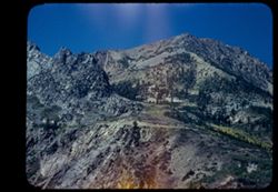
- Description:
- 50 f 9
- Subject:
- Rocks, Yosemite National Park (Calif.), Trees, Lee Vining Creek (Calif.), Tioga Pass (Calif.), Mountains, and Shrubs
- Series:
- 10-54
- Creator:
- Cushman, Charles W., 1896-1972
- Date Created:
- 1954-09-16
- Genre:
- Landscape photographs
- Frame Number:
- 2
- Street Address:
- California State Highway 140
- County:
- Mono
- Abstract:
- Granite + red rock.
- Call Number:
- P07349
- Country:
- United States
- State/Province:
- California
- Physical Description:
- Anscochrome film, masked.
- Alternate Identifier:
- 1054.2
- Persistent URL:
- http://purl.dlib.indiana.edu/iudl/archives/cushman/P07349
- Holding Location:
- Bloomington - University Archives
Wells Library E460
1320 E 10th St.
Bloomington, IN 47405
Contact at archives@indiana.edu, 812-855-1127
-
- Description:
- 50 f 9
- Subject:
- Rocks, Canyons, Trees, Mountains, and Shrubs
- Series:
- 10-54
- Creator:
- Cushman, Charles W., 1896-1972
- Date Created:
- 1954-09-16
- Genre:
- Landscape photographs
- Frame Number:
- 15
- Street Address:
- Tioga Pass Road
- County:
- Mono
- Abstract:
- Two views east down Tioga Pass Rd.
- Call Number:
- P07362
- Country:
- United States
- State/Province:
- California
- Physical Description:
- Anscochrome film.
- Alternate Identifier:
- 1054.15
- Persistent URL:
- http://purl.dlib.indiana.edu/iudl/archives/cushman/P07362
- Holding Location:
- Bloomington - University Archives
Wells Library E460
1320 E 10th St.
Bloomington, IN 47405
Contact at archives@indiana.edu, 812-855-1127
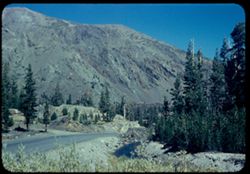
-
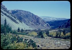
- Description:
- 50 f 9
- Subject:
- Rocks, Canyons, Grasses, Trees, Flowers, Lee Vining Creek (Calif.), Mountains, Shrubs, and Lee Vining Canyon (Calif.)
- Series:
- 10-54
- Creator:
- Cushman, Charles W., 1896-1972
- Date Created:
- 1954-09-16
- Genre:
- Landscape photographs
- Frame Number:
- 21
- County:
- Mono
- Abstract:
- Another view east down canyon.
- Call Number:
- P07368
- Country:
- United States
- State/Province:
- California
- Physical Description:
- Anscochrome film.
- Alternate Identifier:
- 1054.21
- Persistent URL:
- http://purl.dlib.indiana.edu/iudl/archives/cushman/P07368
- Holding Location:
- Bloomington - University Archives
Wells Library E460
1320 E 10th St.
Bloomington, IN 47405
Contact at archives@indiana.edu, 812-855-1127
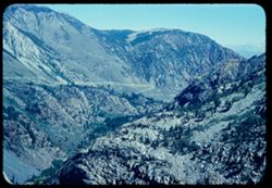
-
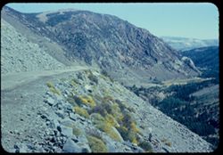
- Description:
- 50 f 10
- Subject:
- Rocks, Canyons, Trees, Lee Vining Creek (Calif.), Mountains, Shrubs, Passes (Landforms), and Valleys
- Series:
- 10-54
- Creator:
- Cushman, Charles W., 1896-1972
- Date Created:
- 1954-09-16
- Genre:
- Landscape photographs
- Frame Number:
- 19
- Street Address:
- Tioga Pass Road
- County:
- Mono
- Abstract:
- View east down Tioga Pass road to Leevining.
- Call Number:
- P07366
- Country:
- United States
- State/Province:
- California
- Physical Description:
- Anscochrome film, film scratched.
- Alternate Identifier:
- 1054.19
- Persistent URL:
- http://purl.dlib.indiana.edu/iudl/archives/cushman/P07366
- Holding Location:
- Bloomington - University Archives
Wells Library E460
1320 E 10th St.
Bloomington, IN 47405
Contact at archives@indiana.edu, 812-855-1127
-
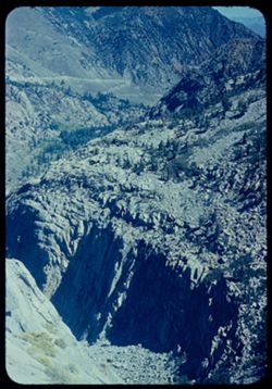
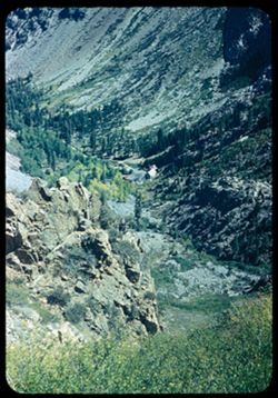
- Description:
- 50 f 8
- Subject:
- Rocks, Canyons, Cliffs, Trees, Lee Vining Creek (Calif.), Mountains, and Shrubs
- Series:
- 10-54
- Creator:
- Cushman, Charles W., 1896-1972
- Date Created:
- 1954-09-16
- Genre:
- Landscape photographs
- Frame Number:
- 20
- Street Address:
- California State Highway 140
- County:
- Mono
- Abstract:
- View down into canyon.
- Call Number:
- P07367
- City:
- Lee Vining
- Country:
- United States
- State/Province:
- California
- Physical Description:
- Anscochrome film.
- Alternate Identifier:
- 1054.20
- Persistent URL:
- http://purl.dlib.indiana.edu/iudl/archives/cushman/P07367
- Holding Location:
- Bloomington - University Archives
Wells Library E460
1320 E 10th St.
Bloomington, IN 47405
Contact at archives@indiana.edu, 812-855-1127
-
- Description:
- 50 f 9
- Subject:
- Rocks, Trees, Tioga Peak (Calif.), Mountains, and Shrubs
- Series:
- 10-54
- Creator:
- Cushman, Charles W., 1896-1972
- Date Created:
- 1954-09-16
- Genre:
- Landscape photographs
- Frame Number:
- 11
- Street Address:
- California State Highway 140
- County:
- Mono
- Abstract:
- Top of Tioga Pk from below.
- Call Number:
- P07358
- Country:
- United States
- State/Province:
- California
- Physical Description:
- Anscochrome film.
- Alternate Identifier:
- 1054.11
- Persistent URL:
- http://purl.dlib.indiana.edu/iudl/archives/cushman/P07358
- Holding Location:
- Bloomington - University Archives
Wells Library E460
1320 E 10th St.
Bloomington, IN 47405
Contact at archives@indiana.edu, 812-855-1127
-
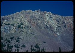
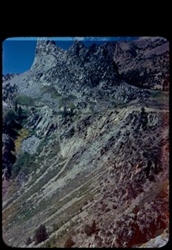
- Description:
- 50 f 8.8
- Subject:
- Yosemite National Park (Calif.), Tioga Peak (Calif.), Mountains, Trees, Streams, Shrubs, Roads, Rocks, and Tioga Pass (Calif.)
- Series:
- 10-54
- Creator:
- Cushman, Charles W., 1896-1972
- Date Created:
- 1954-09-16
- Genre:
- Landscape photographs
- Frame Number:
- 9
- County:
- Mono
- Abstract:
- Great red brown mtn next to Tioga Pk.
- Call Number:
- P07356
- Country:
- United States
- State/Province:
- California
- Physical Description:
- Anscochrome film.
- Alternate Identifier:
- 1054.9
- Persistent URL:
- http://purl.dlib.indiana.edu/iudl/archives/cushman/P07356
- Holding Location:
- Bloomington - University Archives
Wells Library E460
1320 E 10th St.
Bloomington, IN 47405
Contact at archives@indiana.edu, 812-855-1127
-
- Description:
- 50 f 9
- Subject:
- Rocks, Canyons, Mono Basin (Calif.), Trees, Flowers, Lee Vining Creek (Calif.), and Shrubs
- Series:
- 10-54
- Creator:
- Cushman, Charles W., 1896-1972
- Date Created:
- 1954-09-16
- Genre:
- Landscape photographs
- Frame Number:
- 16
- Street Address:
- Tioga Pass Road
- County:
- Mono
- Abstract:
- Two views east down Tioga Pass Rd.
- Call Number:
- P07363
- Country:
- United States
- State/Province:
- California
- Physical Description:
- Anscochrome film.
- Alternate Identifier:
- 1054.16
- Persistent URL:
- http://purl.dlib.indiana.edu/iudl/archives/cushman/P07363
- Holding Location:
- Bloomington - University Archives
Wells Library E460
1320 E 10th St.
Bloomington, IN 47405
Contact at archives@indiana.edu, 812-855-1127
-
- Description:
- 50 f 9
- Subject:
- Rocks, Canyons, Trees, Lee Vining Creek (Calif.), Shrubs, and Dwellings
- Series:
- 10-54
- Creator:
- Cushman, Charles W., 1896-1972
- Date Created:
- 1954-09-16
- Genre:
- Landscape photographs
- Frame Number:
- 18
- Street Address:
- California State Highway 140 and Tioga Pass Road
- County:
- Mono
- Abstract:
- Down into canyon.
- Call Number:
- P07364
- Country:
- United States
- State/Province:
- California
- Physical Description:
- Anscochrome film.
- Alternate Identifier:
- 1054.18
- Persistent URL:
- http://purl.dlib.indiana.edu/iudl/archives/cushman/P07364
- Holding Location:
- Bloomington - University Archives
Wells Library E460
1320 E 10th St.
Bloomington, IN 47405
Contact at archives@indiana.edu, 812-855-1127
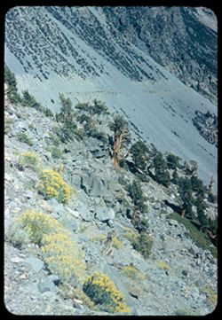
-
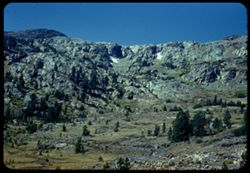
- Description:
- 50 f 8
- Subject:
- Rocks, Tioga Lake (Calif.), Trees, Tioga Pass (Calif.), Shrubs, and Rock formations
- Series:
- 10-54
- Creator:
- Cushman, Charles W., 1896-1972
- Date Created:
- 1954-09-16
- Genre:
- Landscape photographs
- Frame Number:
- 5
- County:
- Mono
- Abstract:
- Granite wall above Tioga Lake.
- Call Number:
- P07352
- Country:
- United States
- State/Province:
- California
- Physical Description:
- Anscochrome film.
- Alternate Identifier:
- 1054.5
- Persistent URL:
- http://purl.dlib.indiana.edu/iudl/archives/cushman/P07352
- Holding Location:
- Bloomington - University Archives
Wells Library E460
1320 E 10th St.
Bloomington, IN 47405
Contact at archives@indiana.edu, 812-855-1127
-
- Description:
- 50 f 10
- Subject:
- Bodies of water, Rocks, Mountains, Trees, Dana Plateau (Calif.), Ellery Lake (Calif.), Shrubs, and Lakes & ponds
- Series:
- 10-54
- Creator:
- Cushman, Charles W., 1896-1972
- Date Created:
- 1954-09-16
- Genre:
- Landscape photographs
- Frame Number:
- 10
- County:
- Mono
- Abstract:
- View east across Ellery Lake.
- Call Number:
- P07357
- Country:
- United States
- State/Province:
- California
- Physical Description:
- Anscochrome film.
- Alternate Identifier:
- 1054.10
- Persistent URL:
- http://purl.dlib.indiana.edu/iudl/archives/cushman/P07357
- Holding Location:
- Bloomington - University Archives
Wells Library E460
1320 E 10th St.
Bloomington, IN 47405
Contact at archives@indiana.edu, 812-855-1127
-
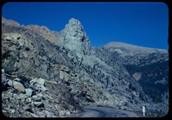
- Description:
- 50 f 9
- Subject:
- Rocks, Roads, Trees, Buttes, Signs (Notices), Tioga Pass (Calif.), Mountains, Rock formations, and Shrubs
- Series:
- 10-54
- Creator:
- Cushman, Charles W., 1896-1972
- Date Created:
- 1954-09-16
- Genre:
- Landscape photographs
- Frame Number:
- 12
- Street Address:
- California State Highway 140 and Tioga Pass Road
- County:
- Mono
- Abstract:
- Granite [pinnacle?] on downgrade of Tioga Pass road.
- Call Number:
- P07359
- Country:
- United States
- State/Province:
- California
- Physical Description:
- Anscochrome film.
- Alternate Identifier:
- 1054.12
- Persistent URL:
- http://purl.dlib.indiana.edu/iudl/archives/cushman/P07359
- Holding Location:
- Bloomington - University Archives
Wells Library E460
1320 E 10th St.
Bloomington, IN 47405
Contact at archives@indiana.edu, 812-855-1127
-
- Description:
- 100 f 6
- Subject:
- Rocks, Trees, Shrubs, and Rock formations
- Series:
- 10-54
- Creator:
- Cushman, Charles W., 1896-1972
- Date Created:
- 1954-09-16
- Genre:
- Landscape photographs
- Frame Number:
- 14
- Street Address:
- Tioga Pass Road
- County:
- Mono
- Abstract:
- The granite pinnacle again.
- Call Number:
- P07361
- Country:
- United States
- State/Province:
- California
- Physical Description:
- Image was originally mounted in a glass enclosure. Before digitization, the image was removed and placed in a Wess Plastic, Inc. brand, 2" x 2", pl...
- Alternate Identifier:
- 1054.14
- Persistent URL:
- http://purl.dlib.indiana.edu/iudl/archives/cushman/P07361
- Holding Location:
- Bloomington - University Archives
Wells Library E460
1320 E 10th St.
Bloomington, IN 47405
Contact at archives@indiana.edu, 812-855-1127
-
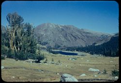
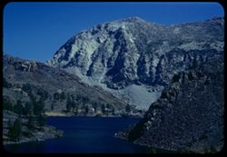
- Description:
- 50 f 9
- Subject:
- Rocks, Bodies of water, Yosemite National Park (Calif.), Trees, Meadows, Tioga Peak (Calif.), Tioga Pass (Calif.), Mountains, Shrubs, Lakes & ponds, and ...
- Series:
- 10-54
- Creator:
- Cushman, Charles W., 1896-1972
- Date Created:
- 1954-09-16
- Genre:
- Landscape photographs
- Frame Number:
- 6
- County:
- Mono
- Abstract:
- Tioga Pk (11,537) across Tioga Lake from entrance to Yosemite Pk.
- Call Number:
- P07353
- Country:
- United States
- State/Province:
- California
- Physical Description:
- Anscochrome film.
- Alternate Identifier:
- 1054.6
- Persistent URL:
- http://purl.dlib.indiana.edu/iudl/archives/cushman/P07353
- Holding Location:
- Bloomington - University Archives
Wells Library E460
1320 E 10th St.
Bloomington, IN 47405
Contact at archives@indiana.edu, 812-855-1127
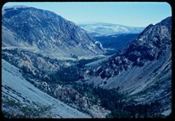
-
- Description:
- 50 f 8
- Subject:
- Rocks, Valleys, Lee Vining Canyon (Calif.), Roads, Mono Basin (Calif.), Trees, Lee Vining Creek (Calif.), Mountains, Shrubs, and Canyons
- Series:
- 10-54
- Creator:
- Cushman, Charles W., 1896-1972
- Date Created:
- 1954-09-16
- Genre:
- Landscape photographs
- Frame Number:
- 22
- County:
- Mono
- Abstract:
- Another view east down canyon - a little vurther along.
- Call Number:
- P07369
- Country:
- United States
- State/Province:
- California
- Physical Description:
- Anscochrome film.
- Alternate Identifier:
- 1054.22
- Persistent URL:
- http://purl.dlib.indiana.edu/iudl/archives/cushman/P07369
- Holding Location:
- Bloomington - University Archives
Wells Library E460
1320 E 10th St.
Bloomington, IN 47405
Contact at archives@indiana.edu, 812-855-1127
-
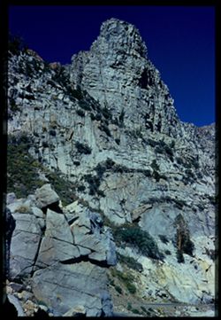
- Description:
- 50 f 9
- Subject:
- Rocks, Valleys, Trees, Lee Vining Creek (Calif.), Tioga Pass (Calif.), Shrubs, and Rock formations
- Series:
- 10-54
- Creator:
- Cushman, Charles W., 1896-1972
- Date Created:
- 1954-09-16
- Genre:
- Landscape photographs
- Frame Number:
- 1
- Street Address:
- California State Highway 140 and Tioga Pass Road
- County:
- Mono
- Abstract:
- Granite up-thrust along Tioga Pass road.
- Call Number:
- P07348
- Country:
- United States
- State/Province:
- California
- Physical Description:
- Anscochrome film, masked.
- Alternate Identifier:
- 1054.1
- Persistent URL:
- http://purl.dlib.indiana.edu/iudl/archives/cushman/P07348
- Holding Location:
- Bloomington - University Archives
Wells Library E460
1320 E 10th St.
Bloomington, IN 47405
Contact at archives@indiana.edu, 812-855-1127