
Search Constraints
You searched for:
Campus
IUB
Remove constraint Campus: IUB
Series
9-54
Remove constraint Series: 9-54
Subject
Mountains
Remove constraint Subject: Mountains
Subject
Shrubs
Remove constraint Subject: Shrubs
1 - 28 of 28
Search Results
-
- Description:
- 50 f 10
- Subject:
- Rocks, Yosemite National Park (Calif.), Trees, Flowers, Volcanoes, Tioga Peak (Calif.), Mountains, and Shrubs
- Series:
- 9-54
- Creator:
- Cushman, Charles W., 1896-1972
- Date Created:
- 1954-09-16
- Genre:
- Landscape photographs
- Frame Number:
- 37
- Street Address:
- California State Highway 140
- County:
- Mono
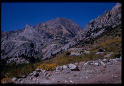
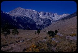
- Abstract:
- Another view up toward Tioga Peak.
- Call Number:
- P07346
- Country:
- United States
- State/Province:
- California
- Physical Description:
- Image was originally mounted in a glass enclosure. Before digitization, the image was removed and placed in a Wess Plastic, Inc. brand, 2" x 2", pl...
- Alternate Identifier:
- 954.37
- Persistent URL:
- http://purl.dlib.indiana.edu/iudl/archives/cushman/P07346
- Holding Location:
- Bloomington - University Archives
Wells Library E460
1320 E 10th St.
Bloomington, IN 47405
Contact at archives@indiana.edu, 812-855-1127
-
- Description:
- 50 f 9
- Subject:
- Passes (Landforms), Rocks, Mountains, Tioga Pass (Calif.), Yosemite Creek (Calif.), Dana Plateau (Calif.), Volcanoes, Shrubs, and Flowers
- Series:
- 9-54
- Creator:
- Cushman, Charles W., 1896-1972
- Date Created:
- 1954-09-16
- Genre:
- Landscape photographs
- Frame Number:
- 36
- County:
- Mono
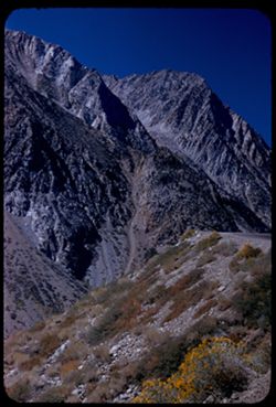
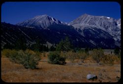
- Abstract:
- Combs above south wall of Tioga Pass from N.
- Call Number:
- P07345
- Country:
- United States
- State/Province:
- California
- Alternate Identifier:
- 954.36
- Persistent URL:
- http://purl.dlib.indiana.edu/iudl/archives/cushman/P07345
- Holding Location:
- Bloomington - University Archives
Wells Library E460
1320 E 10th St.
Bloomington, IN 47405
Contact at archives@indiana.edu, 812-855-1127
-
- Description:
- 50 f 9
- Subject:
- Dana Plateau (Calif.), Mountains, Yosemite National Park (Calif.), Shrubs, Tioga Pass (Calif.), and Volcanoes
- Series:
- 9-54
- Creator:
- Cushman, Charles W., 1896-1972
- Date Created:
- 1954-09-01
- Genre:
- Landscape photographs
- Frame Number:
- 35
- Street Address:
- California State Highway 140
- County:
- Mono
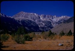
- Abstract:
- Combs above south wall of Tioga Pass from N.
- Call Number:
- P07344
- Country:
- United States
- State/Province:
- California
- Physical Description:
- Image was originally mounted in a glass enclosure. Before digitization, the image was removed and placed in a Wess Plastic, Inc. brand, 2" x 2", pl...
- Alternate Identifier:
- 954.35
- Persistent URL:
- http://purl.dlib.indiana.edu/iudl/archives/cushman/P07344
- Holding Location:
- Bloomington - University Archives
Wells Library E460
1320 E 10th St.
Bloomington, IN 47405
Contact at archives@indiana.edu, 812-855-1127
-
- Description:
- 50 f 10
- Subject:
- Lee Vining Creek (Calif.), Passes (Landforms), Flowers, Mountains, Shrubs, Trees, Rocks, and Tioga Pass (Calif.)
- Series:
- 9-54
- Creator:
- Cushman, Charles W., 1896-1972
- Date Created:
- 1954-09-16
- Genre:
- Landscape photographs
- Frame Number:
- 33
- Street Address:
- California State Highway 140
- County:
- Mono
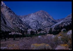
- Abstract:
- Another look up toward Pass.
- Call Number:
- P07343
- Country:
- United States
- State/Province:
- California
- Physical Description:
- Image was originally mounted in a glass enclosure. Before digitization, the image was removed and placed in a Wess Plastic, Inc. brand, 2" x 2", pl...
- Alternate Identifier:
- 954.33
- Persistent URL:
- http://purl.dlib.indiana.edu/iudl/archives/cushman/P07343
- Holding Location:
- Bloomington - University Archives
Wells Library E460
1320 E 10th St.
Bloomington, IN 47405
Contact at archives@indiana.edu, 812-855-1127
-
- Description:
- 50 f 10
- Subject:
- Yosemite National Park (Calif.), Trees, Volcanoes, Meadows, Lee Vining Creek (Calif.), Tioga Pass (Calif.), Mountains, Shrubs, and Passes (Landforms)
- Series:
- 9-54
- Creator:
- Cushman, Charles W., 1896-1972
- Date Created:
- 1954-09-16
- Genre:
- Landscape photographs
- Frame Number:
- 32
- County:
- Mono
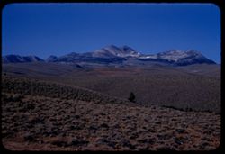
- Abstract:
- View west toward Tioga Pass.
- Call Number:
- P07342
- Country:
- United States
- State/Province:
- California
- Physical Description:
- masked.
- Alternate Identifier:
- 954.32
- Persistent URL:
- http://purl.dlib.indiana.edu/iudl/archives/cushman/P07342
- Holding Location:
- Bloomington - University Archives
Wells Library E460
1320 E 10th St.
Bloomington, IN 47405
Contact at archives@indiana.edu, 812-855-1127
-
- Description:
- 50 f 9
- Subject:
- Rocks, Canyons, Grasses, Roads, Yosemite National Park (Calif.), Trees, Pines, Lee Vining Creek (Calif.), Tioga Peak (Calif.), Tioga Pass (Calif.), Mountains...
- Series:
- 9-54
- Creator:
- Cushman, Charles W., 1896-1972
- Date Created:
- 1954-09-16
- Genre:
- Landscape photographs
- Frame Number:
- 30
- Street Address:
- Tioga Pass Road
- County:
- Mono
- Abstract:
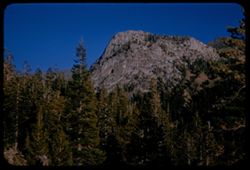
- Tioga Peak from east. 11,537 ft.
- Call Number:
- P07341
- Country:
- United States
- State/Province:
- California
- Alternate Identifier:
- 954.30
- Persistent URL:
- http://purl.dlib.indiana.edu/iudl/archives/cushman/P07341
- Holding Location:
- Bloomington - University Archives
Wells Library E460
1320 E 10th St.
Bloomington, IN 47405
Contact at archives@indiana.edu, 812-855-1127
-
- Description:
- 50 f 9
- Subject:
- Dana Plateau (Calif.), Yosemite National Park (Calif.), Trees, Volcanoes, Dana, Mount (Calif.), Mountains, and Shrubs
- Series:
- 9-54
- Creator:
- Cushman, Charles W., 1896-1972
- Date Created:
- 1954-09-16
- Genre:
- Landscape photographs
- Frame Number:
- 29
- Street Address:
- Tioga Pass Road
- County:
- Mono
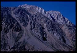
- Abstract:
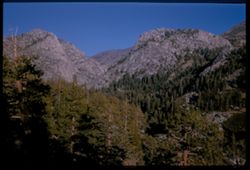
- Top ridge of Mt Dana - last view from E.
- Call Number:
- P07340
- Country:
- United States
- State/Province:
- California
- Alternate Identifier:
- 954.29
- Persistent URL:
- http://purl.dlib.indiana.edu/iudl/archives/cushman/P07340
- Holding Location:
- Bloomington - University Archives
Wells Library E460
1320 E 10th St.
Bloomington, IN 47405
Contact at archives@indiana.edu, 812-855-1127
-
- Description:
- 50 f 10
- Subject:
- Sheep, Lee Vining Creek (Calif.), Deserts, Dana Plateau (Calif.), Roads, Mountains, Yosemite National Park (Calif.), Shrubs, Trees, Rocks, Grazing, Grasses, ...
- Series:
- 9-54
- Creator:
- Cushman, Charles W., 1896-1972
- Date Created:
- 1954-09-16
- Genre:
- Identification photographs
- Frame Number:
- 28
- Street Address:
- Tioga Pass Road
- County:
- Mono
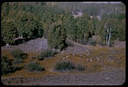
- Abstract:
- Sheep along Tioga Pass road.
- Call Number:
- P07339
- Country:
- United States
- State/Province:
- California
- Physical Description:
- Image was originally mounted in a glass enclosure. Before digitization, the image was removed and placed in a Wess Plastic, Inc. brand, 2" x 2", pl...
- Alternate Identifier:
- 954.28
- Persistent URL:
- http://purl.dlib.indiana.edu/iudl/archives/cushman/P07339
- Holding Location:
- Bloomington - University Archives
Wells Library E460
1320 E 10th St.
Bloomington, IN 47405
Contact at archives@indiana.edu, 812-855-1127
-
- Description:
- 50 f 10
- Subject:
- Lee Vining Creek (Calif.), Deserts, Flowers, Dana, Mount (Calif.), Dana Plateau (Calif.), Roads, Mountains, Yosemite National Park (Calif.), Shrubs, Trees, R...
- Series:
- 9-54
- Creator:
- Cushman, Charles W., 1896-1972
- Date Created:
- 1954-09-16
- Genre:
- Landscape photographs
- Frame Number:
- 27
- County:
- Mono
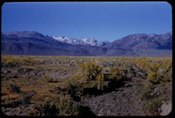
- Abstract:
- Great east wall of Mt. Dana.
- Call Number:
- P07338
- Country:
- United States
- State/Province:
- California
- Alternate Identifier:
- 954.27
- Persistent URL:
- http://purl.dlib.indiana.edu/iudl/archives/cushman/P07338
- Holding Location:
- Bloomington - University Archives
Wells Library E460
1320 E 10th St.
Bloomington, IN 47405
Contact at archives@indiana.edu, 812-855-1127
-
- Description:
- 50 f 9
- Subject:
- Rocks, Dana Plateau (Calif.), Grasses, Yosemite National Park (Calif.), Trees, Volcanoes, Gibbs, Mount (Calif.), Dana, Mount (Calif.), Mountains, and Shrubs
- Series:
- 9-54
- Creator:
- Cushman, Charles W., 1896-1972
- Date Created:
- 1954-09-16
- Genre:
- Landscape photographs
- Frame Number:
- 26
- Street Address:
- Tioga Pass Road
- County:
- Mono
- Abstract:
- Mt. Gibbs - to south of Dana.
- Call Number:
- P07337
- Country:
- United States
- State/Province:
- California
- Alternate Identifier:
- 954.26
- Persistent URL:
- http://purl.dlib.indiana.edu/iudl/archives/cushman/P07337
- Holding Location:
- Bloomington - University Archives
Wells Library E460
1320 E 10th St.
Bloomington, IN 47405
Contact at archives@indiana.edu, 812-855-1127
-
- Description:
- 50 f 11
- Subject:
- Dana, Mount (Calif.), Mountains, Yosemite National Park (Calif.), Shrubs, Trees, Rocks, Grasses, and Volcanoes
- Series:
- 9-54
- Creator:
- Cushman, Charles W., 1896-1972
- Date Created:
- 1954-09-16
- Genre:
- Landscape photographs
- Frame Number:
- 25
- Street Address:
- Tioga Pass Road
- County:
- Mono
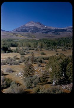
- Abstract:
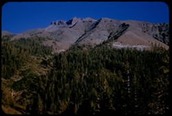
- Mt. Dana from east. (13,050 elev.)
- Call Number:
- P07336
- Country:
- United States
- State/Province:
- California
- Alternate Identifier:
- 954.25
- Persistent URL:
- http://purl.dlib.indiana.edu/iudl/archives/cushman/P07336
- Holding Location:
- Bloomington - University Archives
Wells Library E460
1320 E 10th St.
Bloomington, IN 47405
Contact at archives@indiana.edu, 812-855-1127
-
- Description:
- 50 f 9
- Subject:
- Bodies of water, Coastlines, Mountains, Shrubs, Lakes & ponds, Hills, and Mono Lake (Calif.)
- Series:
- 9-54
- Creator:
- Cushman, Charles W., 1896-1972
- Date Created:
- 1954-09-16
- Genre:
- Landscape photographs
- Frame Number:
- 24
- County:
- Mono
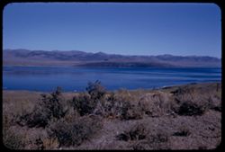
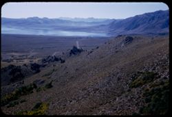
- Abstract:
- View across Mono Lake.
- Call Number:
- P07335
- Country:
- United States
- State/Province:
- California
- Alternate Identifier:
- 954.24
- Persistent URL:
- http://purl.dlib.indiana.edu/iudl/archives/cushman/P07335
- Holding Location:
- Bloomington - University Archives
Wells Library E460
1320 E 10th St.
Bloomington, IN 47405
Contact at archives@indiana.edu, 812-855-1127
-
- Description:
- 50 f 8
- Subject:
- Bodies of water, Roads, Trees, Mountains, Shrubs, Lakes & ponds, Hills, and Mono Lake (Calif.)
- Series:
- 9-54
- Creator:
- Cushman, Charles W., 1896-1972
- Date Created:
- 1954-09-16
- Genre:
- Landscape photographs
- Frame Number:
- 22
- Street Address:
- United States Highway 395
- County:
- Mono
- Abstract:
- Looking down from north on west end of Mono Lake.
- Call Number:
- P07333
- Country:
- United States
- State/Province:
- California
- Alternate Identifier:
- 954.22
- Persistent URL:
- http://purl.dlib.indiana.edu/iudl/archives/cushman/P07333
- Holding Location:
- Bloomington - University Archives
Wells Library E460
1320 E 10th St.
Bloomington, IN 47405
Contact at archives@indiana.edu, 812-855-1127
-
- Description:
- 50 f 11
- Subject:
- Deserts, Valleys, Trees, Flowers, Conway Summit (Calif.), Mountains, Shrubs, and Hills
- Series:
- 9-54
- Creator:
- Cushman, Charles W., 1896-1972
- Date Created:
- 1954-09-16
- Genre:
- Landscape photographs
- Frame Number:
- 21
- Street Address:
- United States Highway 395
- County:
- Mono
- Abstract:
- View north (w.) from US 395, 12 1/2 mi. so of Bridgeport. (19-20-21 were taken less than mile north of Conway Summit)
- Call Number:
- P07332
- City:
- Bridgeport
- Country:
- United States
- State/Province:
- California
- Alternate Identifier:
- 954.21
- Persistent URL:
- http://purl.dlib.indiana.edu/iudl/archives/cushman/P07332
- Holding Location:
- Bloomington - University Archives
Wells Library E460
1320 E 10th St.
Bloomington, IN 47405
Contact at archives@indiana.edu, 812-855-1127
-
- Description:
- 50 f 9
- Subject:
- Sheep, Hills, Mountains, Shrubs, Sierra Nevada (Calif. and Nev.), Trees, Grazing, Grasses, and Dunderberg Peak (Calif.)
- Series:
- 9-54
- Creator:
- Cushman, Charles W., 1896-1972
- Date Created:
- 1954-09-16
- Genre:
- Landscape photographs
- Frame Number:
- 20
- Street Address:
- United States Highway 395
- County:
- Mono
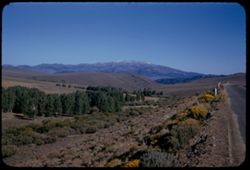
- Abstract:
- Sheep below - looking toward Dunderberg Pk. (19-20-21 were taken less than mile north of Conway Summit)
- Call Number:
- P07331
- City:
- Bridgeport
- Country:
- United States
- State/Province:
- California
- Physical Description:
- masked.
- Alternate Identifier:
- 954.20
- Persistent URL:
- http://purl.dlib.indiana.edu/iudl/archives/cushman/P07331
- Holding Location:
- Bloomington - University Archives
Wells Library E460
1320 E 10th St.
Bloomington, IN 47405
Contact at archives@indiana.edu, 812-855-1127
-
- Description:
- 50 f 9
- Subject:
- Grasses, Grazing, Trees, Conway Summit (Calif.), Mountains, Shrubs, Sheep, and Hills
- Series:
- 9-54
- Creator:
- Cushman, Charles W., 1896-1972
- Date Created:
- 1954-09-16
- Genre:
- Identification photographs
- Frame Number:
- 19
- Street Address:
- United States Highway 395
- County:
- Mono
- Abstract:
- Sheep below. (19-20-21 were taken less than mile north of Conway Summit)
- Call Number:
- P07330
- City:
- Bridgeport
- Country:
- United States
- State/Province:
- California
- Alternate Identifier:
- 954.19
- Persistent URL:
- http://purl.dlib.indiana.edu/iudl/archives/cushman/P07330
- Holding Location:
- Bloomington - University Archives
Wells Library E460
1320 E 10th St.
Bloomington, IN 47405
Contact at archives@indiana.edu, 812-855-1127
-
- Description:
- 50 f 11
- Subject:
- Trees, Mountains, Shrubs, Dunderberg Peak (Calif.), and Hills
- Series:
- 9-54
- Creator:
- Cushman, Charles W., 1896-1972
- Date Created:
- 1954-09-16
- Genre:
- Landscape photographs
- Frame Number:
- 18
- Street Address:
- United States Highway 395
- County:
- Mono
- Abstract:
- Dunderberg Pk., 12,368, from US 395, 8 1/2 mi. south of Bridgeport.
- Call Number:
- P07329
- City:
- Bridgeport
- Country:
- United States
- State/Province:
- California
- Alternate Identifier:
- 954.18
- Persistent URL:
- http://purl.dlib.indiana.edu/iudl/archives/cushman/P07329
- Holding Location:
- Bloomington - University Archives
Wells Library E460
1320 E 10th St.
Bloomington, IN 47405
Contact at archives@indiana.edu, 812-855-1127
-
- Description:
- 50 f 11
- Subject:
- Sawtooth Ridge (Calif.), Twin Peaks (San Francisco County, Calif.), Dirt roads, Flowers, Matterhorn Peak (Calif.), Mountains, Shrubs, Sierra Nevada (Calif. a...
- Series:
- 9-54
- Creator:
- Cushman, Charles W., 1896-1972
- Date Created:
- 1954-09-16
- Genre:
- Landscape photographs
- Frame Number:
- 17
- Street Address:
- United States Highway 395
- County:
- Mono
- Abstract:
- Matterhorn and Twin Peaks from Hwy 395 to NE (?). Mountains of Sawtooth Ridge, all over, 11,000 ft.
- Call Number:
- P07328
- City:
- Bridgeport
- Country:
- United States
- State/Province:
- California
- Alternate Identifier:
- 954.17
- Persistent URL:
- http://purl.dlib.indiana.edu/iudl/archives/cushman/P07328
- Holding Location:
- Bloomington - University Archives
Wells Library E460
1320 E 10th St.
Bloomington, IN 47405
Contact at archives@indiana.edu, 812-855-1127
-
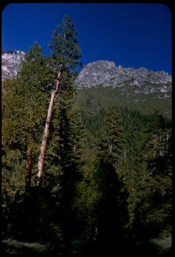
High crag above highway Cal 108 at 9624 ft. Sonora Pass. Tuolumne County, California's High Sierras.
- Description:
- 50 f 9
- Subject:
- Rocks, Sonora Pass (Calif.), Shadows, Mountains, Rock formations, and Shrubs
- Series:
- 9-54
- Creator:
- Cushman, Charles W., 1896-1972
- Date Created:
- 1954-09-15
- Genre:
- Landscape photographs
- Frame Number:
- 14
- Street Address:
- California State Highway 108
- County:
- Tuolumne
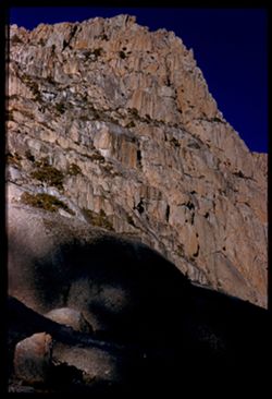
- Abstract:
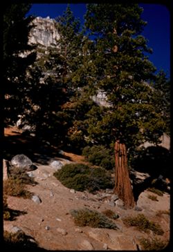
- Looking up at great crag - (207.5 mi.) Summit - 9624 ft. 211 mi.
- Call Number:
- P07325
- Country:
- United States
- State/Province:
- California
- Physical Description:
- Image was originally mounted in a glass enclosure. Before digitization, the image was removed and placed in a Wess Plastic, Inc. brand, 2" x 2", pl...
- Alternate Identifier:
- 954.14
- Persistent URL:
- http://purl.dlib.indiana.edu/iudl/archives/cushman/P07325
- Holding Location:
- Bloomington - University Archives
Wells Library E460
1320 E 10th St.
Bloomington, IN 47405
Contact at archives@indiana.edu, 812-855-1127
-
- Description:
- 50 f 9
- Subject:
- Roads, Sonora Pass (Calif.), Trees, Shadows, Mountains, Shrubs, and Passes (Landforms)
- Series:
- 9-54
- Creator:
- Cushman, Charles W., 1896-1972
- Date Created:
- 1954-09-15
- Genre:
- Landscape photographs
- Frame Number:
- 13
- Street Address:
- California State Highway 108
- County:
- Tuolumne
- Abstract:
- East at 206.6 (8000 ft.)
- Call Number:
- P07324
- Country:
- United States
- State/Province:
- California
- Alternate Identifier:
- 954.13
- Persistent URL:
- http://purl.dlib.indiana.edu/iudl/archives/cushman/P07324
- Holding Location:
- Bloomington - University Archives
Wells Library E460
1320 E 10th St.
Bloomington, IN 47405
Contact at archives@indiana.edu, 812-855-1127
-
- Description:
- 50 f 11
- Subject:
- Passes (Landforms), Sonora Pass (Calif.), Mountains, Trees, and Shrubs
- Series:
- 9-54
- Creator:
- Cushman, Charles W., 1896-1972
- Date Created:
- 1954-09-15
- Genre:
- Landscape photographs
- Frame Number:
- 12
- County:
- Tuolumne
- Abstract:
- East toward Sonora Pass from 206.3 mi.
- Call Number:
- P07323
- Country:
- United States
- State/Province:
- California
- Alternate Identifier:
- 954.12
- Persistent URL:
- http://purl.dlib.indiana.edu/iudl/archives/cushman/P07323
- Holding Location:
- Bloomington - University Archives
Wells Library E460
1320 E 10th St.
Bloomington, IN 47405
Contact at archives@indiana.edu, 812-855-1127
-
- Description:
- 50 f 9
- Subject:
- Passes (Landforms), Mountains, Shrubs, Trees, and Sonora Pass (Calif.)
- Series:
- 9-54
- Creator:
- Cushman, Charles W., 1896-1972
- Date Created:
- 1954-09-15
- Genre:
- Landscape photographs
- Frame Number:
- 11
- County:
- Tuolumne
- Abstract:
- East toward Sonora Pass at 206 mi.
- Call Number:
- P07322
- Country:
- United States
- State/Province:
- California
- Physical Description:
- Image was originally mounted in a glass enclosure. Before digitization, the image was removed and placed in a Wess Plastic, Inc. brand, 2" x 2", pl...
- Alternate Identifier:
- 954.11
- Persistent URL:
- http://purl.dlib.indiana.edu/iudl/archives/cushman/P07322
- Holding Location:
- Bloomington - University Archives
Wells Library E460
1320 E 10th St.
Bloomington, IN 47405
Contact at archives@indiana.edu, 812-855-1127
-
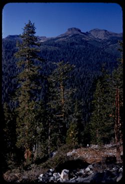
- Description:
- 50 f 9
- Subject:
- Passes (Landforms), Mountains, Shrubs, Trees, Buttes, and Sonora Pass (Calif.)
- Series:
- 9-54
- Creator:
- Cushman, Charles W., 1896-1972
- Date Created:
- 1954-09-15
- Genre:
- Landscape photographs
- Frame Number:
- 10
- County:
- Tuolumne
- Abstract:
- Cone above Sonora Pass - to south.
- Call Number:
- P07321
- Country:
- United States
- State/Province:
- California
- Alternate Identifier:
- 954.10
- Persistent URL:
- http://purl.dlib.indiana.edu/iudl/archives/cushman/P07321
- Holding Location:
- Bloomington - University Archives
Wells Library E460
1320 E 10th St.
Bloomington, IN 47405
Contact at archives@indiana.edu, 812-855-1127
-
- Description:
- 50 f 8
- Subject:
- Passes (Landforms), Sonora Peak (Calif.), Redwoods, Mountains, Shrubs, Sierra Nevada (Calif. and Nev.), Trees, Rocks, Sonora Pass (Calif.), and Rock formations
- Series:
- 9-54
- Creator:
- Cushman, Charles W., 1896-1972
- Date Created:
- 1954-09-15
- Genre:
- Identification photographs
- Frame Number:
- 9
- Street Address:
- California State Highway 108
- County:
- Tuolumne
- Abstract:
- Up at redwood (203 mi.)
- Call Number:
- P07320
- Country:
- United States
- State/Province:
- California
- Alternate Identifier:
- 954.9
- Persistent URL:
- http://purl.dlib.indiana.edu/iudl/archives/cushman/P07320
- Holding Location:
- Bloomington - University Archives
Wells Library E460
1320 E 10th St.
Bloomington, IN 47405
Contact at archives@indiana.edu, 812-855-1127
-
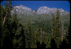
- Description:
- 50 f 8
- Subject:
- Grasses, Trees, Shadows, Buttes, Mountains, Rock formations, Sonora Peak (Calif.), and Shrubs
- Series:
- 9-54
- Creator:
- Cushman, Charles W., 1896-1972
- Date Created:
- 1954-09-15
- Genre:
- Landscape photographs
- Frame Number:
- 7
- Street Address:
- Sonora Pass Road
- County:
- Tuolumne
- Abstract:
- Up at sun lit escarpment east of Dardanelle.
- Call Number:
- P07318
- City:
- Dardanelle
- Country:
- United States
- State/Province:
- California
- Alternate Identifier:
- 954.7
- Persistent URL:
- http://purl.dlib.indiana.edu/iudl/archives/cushman/P07318
- Holding Location:
- Bloomington - University Archives
Wells Library E460
1320 E 10th St.
Bloomington, IN 47405
Contact at archives@indiana.edu, 812-855-1127
-
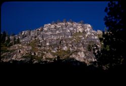
- Description:
- 50 f 8
- Subject:
- Rocks, Grasses, Trees, Buttes, Stanislaus River (Calif.), Mountains, Rock formations, and Shrubs
- Series:
- 9-54
- Creator:
- Cushman, Charles W., 1896-1972
- Date Created:
- 1954-09-15
- Genre:
- Landscape photographs
- Frame Number:
- 6
- Street Address:
- California State Highway 108
- County:
- Tuolumne
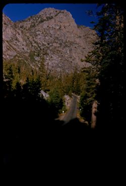
- Abstract:
- Looking up at granite ridge from Hwy 108 far below. 5:30 PM.
- Call Number:
- P07317
- City:
- Dardanelle
- Country:
- United States
- State/Province:
- California
- Alternate Identifier:
- 954.6
- Persistent URL:
- http://purl.dlib.indiana.edu/iudl/archives/cushman/P07317
- Holding Location:
- Bloomington - University Archives
Wells Library E460
1320 E 10th St.
Bloomington, IN 47405
Contact at archives@indiana.edu, 812-855-1127
-
- Description:
- 50 f 8
- Subject:
- Rocks, Stanislaus River Canyon (Calif.), Grasses, Trees, Buttes, Mountains, Shrubs, and Rock formations
- Series:
- 9-54
- Creator:
- Cushman, Charles W., 1896-1972
- Date Created:
- 1954-09-15
- Genre:
- Landscape photographs
- Frame Number:
- 5
- Street Address:
- California State Highway 108
- County:
- Tuolumne
- Abstract:
- Looking up at granite ridge from Hwy 108 far below. 5:30 PM.
- Call Number:
- P07316
- City:
- Dardanelle
- Country:
- United States
- State/Province:
- California
- Alternate Identifier:
- 954.5
- Persistent URL:
- http://purl.dlib.indiana.edu/iudl/archives/cushman/P07316
- Holding Location:
- Bloomington - University Archives
Wells Library E460
1320 E 10th St.
Bloomington, IN 47405
Contact at archives@indiana.edu, 812-855-1127
-
- Description:
- 50 f 8
- Subject:
- Rocks, Canyons, Trees, Volcanoes, Buttes, Dardanelles Butte (Calif.), Stanislaus River (Calif.), Mountains, Shrubs, Lava flows, and Dardanelles Cone (Calif.)
- Series:
- 9-54
- Creator:
- Cushman, Charles W., 1896-1972
- Date Created:
- 1954-09-15
- Genre:
- Landscape photographs
- Frame Number:
- 2
- Street Address:
- California State Highway 1 and California State Highway 108
- County:
- Tuolumne
- Abstract:
- Dardanelles Cone. Looking north across canyon from Hwy 108 about 8 or 9 miles w. of Dardanelle.
- Call Number:
- P07313
- City:
- Dardanelle
- Country:
- United States
- State/Province:
- California
- Alternate Identifier:
- 954.2
- Persistent URL:
- http://purl.dlib.indiana.edu/iudl/archives/cushman/P07313
- Holding Location:
- Bloomington - University Archives
Wells Library E460
1320 E 10th St.
Bloomington, IN 47405
Contact at archives@indiana.edu, 812-855-1127