
Search Constraints
You searched for:
Campus
IUB
Remove constraint Campus: IUB
Subject
Hills
Remove constraint Subject: Hills
Subject
Canyons
Remove constraint Subject: Canyons
« Previous |
1 - 50 of 69
|
Next »
Search Results
-
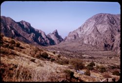
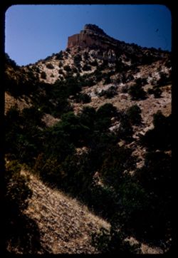
- Description:
- 50 f 8
- Subject:
- Valleys, Hills, Mountains, Lost Mine Trail (Big Bend National Park (Tex.)), Trees, Canyons, National parks & reserves, Big Bend National Park (Tex.), Cli...
- Series:
- 16-51
- Creator:
- Cushman, Charles W., 1896-1972
- Date Created:
- 1951-12-27
- Genre:
- Landscape photographs
- Frame Number:
- 11
- County:
- Brewster
- Abstract:
- Road winds down to The Basin
- Call Number:
- P05430
- Country:
- United States
- State/Province:
- Texas
- Alternate Identifier:
- 1651.11
- Persistent URL:
- http://purl.dlib.indiana.edu/iudl/archives/cushman/P05430
- Holding Location:
- Bloomington - University Archives
Wells Library E460
1320 E 10th St.
Bloomington, IN 47405
Contact at archives@indiana.edu, 812-855-1127
-
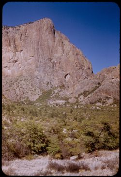
- Description:
- 25 f 11
- Subject:
- Noon, National parks & reserves, Pulliam Peak (Tex.), Canyons, Valleys, Hills, Cliffs, Big Bend National Park (Tex.), Mountains, Shrubs, Trees, Basin (Bi...
- Series:
- 16-51
- Creator:
- Cushman, Charles W., 1896-1972
- Date Created:
- 1951-12-27
- Genre:
- Landscape photographs
- Frame Number:
- 5
- County:
- Brewster
- Abstract:
- Great bold front of Pulliam Pk. From Green gulch from south
- Call Number:
- P05424
- Country:
- United States
- State/Province:
- Texas
- Alternate Identifier:
- 1651.5
- Persistent URL:
- http://purl.dlib.indiana.edu/iudl/archives/cushman/P05424
- Holding Location:
- Bloomington - University Archives
Wells Library E460
1320 E 10th St.
Bloomington, IN 47405
Contact at archives@indiana.edu, 812-855-1127
-
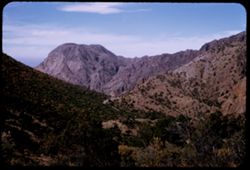
- Description:
- 25 f 11
- Subject:
- Canyons, Roads, Trees, Tree limbs, Mountains, Shrubs, Lost Mine Trail (Big Bend National Park (Tex.)), Hills, Big Bend National Park (Tex.), and National par...
- Series:
- 16-51
- Creator:
- Cushman, Charles W., 1896-1972
- Date Created:
- 1951-12-28
- Genre:
- Landscape photographs
- Frame Number:
- 29
- County:
- Brewster
- Abstract:
- View west down canyon.
- Call Number:
- P05447
- Country:
- United States
- State/Province:
- Texas
- Alternate Identifier:
- 1651.29
- Persistent URL:
- http://purl.dlib.indiana.edu/iudl/archives/cushman/P05447
- Holding Location:
- Bloomington - University Archives
Wells Library E460
1320 E 10th St.
Bloomington, IN 47405
Contact at archives@indiana.edu, 812-855-1127
-
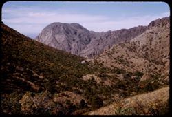
- Description:
- 25 f 11
- Subject:
- Canyons, Roads, Trees, Tree limbs, Mountains, National parks & reserves, Lost Mine Trail (Big Bend National Park (Tex.)), Hills, Big Bend National Park (...
- Series:
- 16-51
- Creator:
- Cushman, Charles W., 1896-1972
- Date Created:
- 1951-12-28
- Genre:
- Landscape photographs
- Frame Number:
- 30
- County:
- Brewster
- Abstract:
- View west down canyon.
- Call Number:
- P05448
- Country:
- United States
- State/Province:
- Texas
- Alternate Identifier:
- 1651.30
- Persistent URL:
- http://purl.dlib.indiana.edu/iudl/archives/cushman/P05448
- Holding Location:
- Bloomington - University Archives
Wells Library E460
1320 E 10th St.
Bloomington, IN 47405
Contact at archives@indiana.edu, 812-855-1127
-
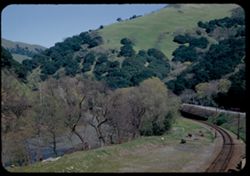
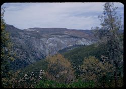
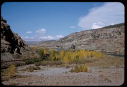
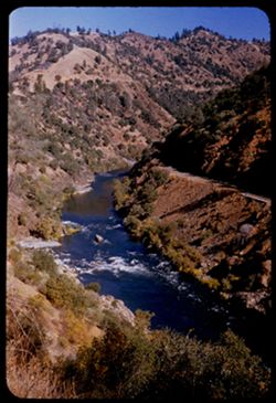
- Description:
- 25 f 9
- Subject:
- Canyons, Hills, Roads, Stonybrook Creek (Alameda County, Calif.), Railroad tracks, Trees, Streams, and Grasses
- Series:
- 11-52
- Creator:
- Cushman, Charles W., 1896-1972
- Date Created:
- 1952-03-21
- Genre:
- Landscape photographs
- Frame Number:
- 29
- County:
- Alameda
- Abstract:
- Through canyon where runs Stony Brook.
- Call Number:
- P05897
- Country:
- United States
- State/Province:
- California
- Alternate Identifier:
- 1152.29
- Persistent URL:
- http://purl.dlib.indiana.edu/iudl/archives/cushman/P05897
- Holding Location:
- Bloomington - University Archives
Wells Library E460
1320 E 10th St.
Bloomington, IN 47405
Contact at archives@indiana.edu, 812-855-1127
-

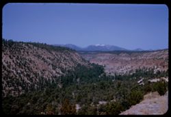
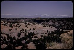
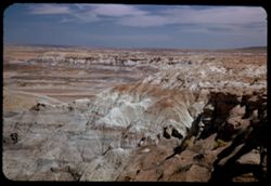
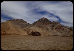
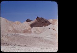
- Description:
- 25 f 14
- Subject:
- Deserts, Amargosa Range (Nev. and Calif.), Valleys, Hills, Death Valley (Calif. and Nev.), Cliffs, Mountains, Shrubs, Rocks, Canyons, and Desolation Canyon (...
- Series:
- 15-52
- Creator:
- Cushman, Charles W., 1896-1972
- Date Created:
- 1952-04-09
- Genre:
- Landscape photographs
- Frame Number:
- 21
- Street Address:
- Bad Water Road
- County:
- Inyo
- Abstract:
- Approx. same.
- Call Number:
- P06041
- City:
- Furnace Creek
- Country:
- United States
- State/Province:
- California
- Alternate Identifier:
- 1552.21
- Persistent URL:
- http://purl.dlib.indiana.edu/iudl/archives/cushman/P06041
- Holding Location:
- Bloomington - University Archives
Wells Library E460
1320 E 10th St.
Bloomington, IN 47405
Contact at archives@indiana.edu, 812-855-1127
-
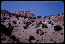
- Description:
- 25 f 13
- Subject:
- Valleys, Polvadera Peak (N.M.), Mesas, Mountains, Shrubs, Hills, Canyons, Trees, and Frijoles Canyon (Colo. and N.M.)
- Series:
- 18-52
- Creator:
- Cushman, Charles W., 1896-1972
- Date Created:
- 1952-04-15
- Genre:
- Landscape photographs
- Frame Number:
- 23
- County:
- Rio Arriba
- Abstract:
- View north down Frijoles Canyon.
- Call Number:
- P06153
- Country:
- United States
- State/Province:
- New Mexico
- Alternate Identifier:
- 1852.23
- Persistent URL:
- http://purl.dlib.indiana.edu/iudl/archives/cushman/P06153
- Holding Location:
- Bloomington - University Archives
Wells Library E460
1320 E 10th St.
Bloomington, IN 47405
Contact at archives@indiana.edu, 812-855-1127
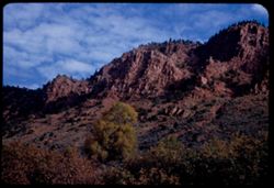
-
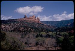
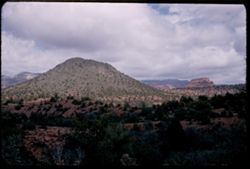
- Description:
- 25 f 13
- Subject:
- Canyons, Cliffs, Trees, Mountains, Rock formations, Clouds, Hills, and Oak Creek Canyon (Ariz.)
- Series:
- 16-52
- Creator:
- Cushman, Charles W., 1896-1972
- Date Created:
- 1952-04-12
- Genre:
- Landscape photographs
- Frame Number:
- 35
- County:
- Coconino
- Abstract:
- Contorted red rocks Sedona
- Call Number:
- P06093
- City:
- Sedona
- Country:
- United States
- State/Province:
- Arizona
- Alternate Identifier:
- 1652.35
- Persistent URL:
- http://purl.dlib.indiana.edu/iudl/archives/cushman/P06093
- Holding Location:
- Bloomington - University Archives
Wells Library E460
1320 E 10th St.
Bloomington, IN 47405
Contact at archives@indiana.edu, 812-855-1127
-
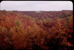
- Description:
- 25 f 5.6 Pola
- Subject:
- Canyons, Trees, Birches, and Hills
- Series:
- 22-52
- Creator:
- Cushman, Charles W., 1896-1972
- Date Created:
- 1952-10-27
- Genre:
- Landscape photographs
- Frame Number:
- 11
- County:
- Teller
- Abstract:
- Stand of birch in canyon above Cripple Creek
- Call Number:
- P06265
- City:
- Cripple Creek
- Country:
- United States
- State/Province:
- Colorado
- Alternate Identifier:
- 2252.11
- Persistent URL:
- http://purl.dlib.indiana.edu/iudl/archives/cushman/P06265
- Holding Location:
- Bloomington - University Archives
Wells Library E460
1320 E 10th St.
Bloomington, IN 47405
Contact at archives@indiana.edu, 812-855-1127
-
- Description:
- 25 f 4.5
- Subject:
- Canyons, Trees, Mountains, Ozark Mountains, and Hills
- Series:
- 20-52
- Creator:
- Cushman, Charles W., 1896-1972
- Date Created:
- 1952-10-21
- Genre:
- Landscape photographs
- Frame Number:
- 20
- Street Address:
- United States Highway 62
- County:
- Carroll
- Abstract:
- View into nearby canyon
- Call Number:
- P06212
- City:
- Eureka Springs
- Country:
- United States
- State/Province:
- Arkansas
- Alternate Identifier:
- 2052.20
- Persistent URL:
- http://purl.dlib.indiana.edu/iudl/archives/cushman/P06212
- Holding Location:
- Bloomington - University Archives
Wells Library E460
1320 E 10th St.
Bloomington, IN 47405
Contact at archives@indiana.edu, 812-855-1127
-
- Description:
- 25 f 9 Pola
- Subject:
- Canyons, Roads, Trees, Bandelier National Monument (N.M.), Mountains, National parks & reserves, Sangre de Cristo Mountains (Colo. and N.M.), Hills, and ...
- Series:
- 18-52
- Creator:
- Cushman, Charles W., 1896-1972
- Date Created:
- 1952-04-15
- Genre:
- Landscape photographs
- Frame Number:
- 26
- Abstract:
- Down same canyon.
- Call Number:
- P06157
- Country:
- United States
- State/Province:
- New Mexico
- Alternate Identifier:
- 1852.26
- Persistent URL:
- http://purl.dlib.indiana.edu/iudl/archives/cushman/P06157
- Holding Location:
- Bloomington - University Archives
Wells Library E460
1320 E 10th St.
Bloomington, IN 47405
Contact at archives@indiana.edu, 812-855-1127
-
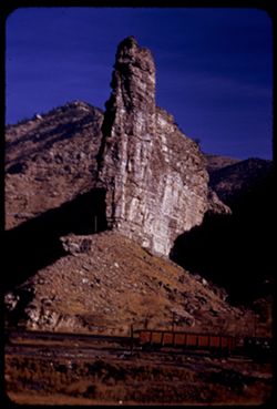
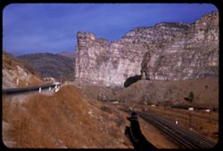
- Description:
- 25 f 11
- Subject:
- Scylla and Charybdis (Greek mythology), Canyons, Electric lines, Cliffs, Charybdis, Buttes, Mountains, Denver and Rio Grande Western Railway Company, Rock fo...
- Series:
- 27-52
- Creator:
- Cushman, Charles W., 1896-1972
- Date Created:
- 1952-11-05
- Genre:
- Landscape photographs
- Frame Number:
- 32
- County:
- Carbon
- Abstract:
- Scylla + Charydis at Royal on Price river.
- Call Number:
- P06477
- City:
- Royal
- Country:
- United States
- State/Province:
- Utah
- Alternate Identifier:
- 2752.32
- Persistent URL:
- http://purl.dlib.indiana.edu/iudl/archives/cushman/P06477
- Holding Location:
- Bloomington - University Archives
Wells Library E460
1320 E 10th St.
Bloomington, IN 47405
Contact at archives@indiana.edu, 812-855-1127
-
- Description:
- 50 f 6.3 Pola
- Subject:
- Deserts, Canyons, Trees, Shrubs, Hills, Painted Desert (Ariz.), and Valleys
- Series:
- 17-52
- Creator:
- Cushman, Charles W., 1896-1972
- Date Created:
- 1952-04-12
- Genre:
- Landscape photographs
- Frame Number:
- 4
- County:
- Navajo and Coconimo
- Abstract:
- Same
- Call Number:
- P06098
- City:
- Holbrook
- Country:
- United States
- State/Province:
- Arizona
- Alternate Identifier:
- 1752.4
- Persistent URL:
- http://purl.dlib.indiana.edu/iudl/archives/cushman/P06098
- Holding Location:
- Bloomington - University Archives
Wells Library E460
1320 E 10th St.
Bloomington, IN 47405
Contact at archives@indiana.edu, 812-855-1127
-
- Description:
- 25 f 9
- Subject:
- Canyons, Roads, Mountains, Denver and Rio Grande Western Railway Company, Rock formations, Railroad tracks, Railroad cars, Coal, Cliffs, Buildings, Price Riv...
- Series:
- 27-52
- Creator:
- Cushman, Charles W., 1896-1972
- Date Created:
- 1952-11-05
- Genre:
- Landscape photographs
- Frame Number:
- 31
- Street Address:
- United States Highway 50
- County:
- Carbon
- Abstract:
- Hwy 50 runs through Price river gorge along with D + RGW at Royal, north of Helper.
- Call Number:
- P06476
- City:
- Royal and Helper
- Country:
- United States
- State/Province:
- Utah
- Alternate Identifier:
- 2752.31
- Persistent URL:
- http://purl.dlib.indiana.edu/iudl/archives/cushman/P06476
- Holding Location:
- Bloomington - University Archives
Wells Library E460
1320 E 10th St.
Bloomington, IN 47405
Contact at archives@indiana.edu, 812-855-1127
-
- Description:
- 25 f 11
- Subject:
- Canyons, Trees, Stanislaus River (Calif.), Tree limbs, Shrubs, and Hills
- Series:
- 13-52
- Creator:
- Cushman, Charles W., 1896-1972
- Date Created:
- 1952-04-05
- Genre:
- Landscape photographs
- Frame Number:
- 20
- Street Address:
- Columbia Vallecito Highway and Columbia-Vallecito Road
- County:
- Tuolumne and Calaveras
- Abstract:
- Canyon of the Stanislaus river - seen from Columbia Vallecito Hwy.
- Call Number:
- P05965
- City:
- Columbia
- Country:
- United States
- State/Province:
- California
- Alternate Identifier:
- 1352.20
- Persistent URL:
- http://purl.dlib.indiana.edu/iudl/archives/cushman/P05965
- Holding Location:
- Bloomington - University Archives
Wells Library E460
1320 E 10th St.
Bloomington, IN 47405
Contact at archives@indiana.edu, 812-855-1127
-
- Description:
- 25 f 16
- Subject:
- National parks & reserves, Canyons, Hills, Cliffs, Mountains, Shrubs, Bandelier National Monument (N.M.), Trees, Rock formations, and Boulders
- Series:
- 18-52
- Creator:
- Cushman, Charles W., 1896-1972
- Date Created:
- 1952-04-15
- Genre:
- Landscape photographs
- Frame Number:
- 27
- Abstract:
- Up again like 24.
- Call Number:
- P06158
- Country:
- United States
- State/Province:
- New Mexico
- Alternate Identifier:
- 1852.27
- Persistent URL:
- http://purl.dlib.indiana.edu/iudl/archives/cushman/P06158
- Holding Location:
- Bloomington - University Archives
Wells Library E460
1320 E 10th St.
Bloomington, IN 47405
Contact at archives@indiana.edu, 812-855-1127
-
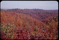
- Description:
- 25 f 9
- Subject:
- Tree limbs, Canyons, Hills, Ozark Mountains, Mountains, and Trees
- Series:
- 20-52
- Creator:
- Cushman, Charles W., 1896-1972
- Date Created:
- 1952-10-22
- Genre:
- Landscape photographs
- Frame Number:
- 22
- Street Address:
- United States Highway 62
- County:
- Benton and Carroll
- Abstract:
- Canyon view from US 62 between Gateway and Eureka Springs
- Call Number:
- P06214
- City:
- Eureka Springs and Gateway
- Country:
- United States
- State/Province:
- Arkansas
- Alternate Identifier:
- 2052.22
- Persistent URL:
- http://purl.dlib.indiana.edu/iudl/archives/cushman/P06214
- Holding Location:
- Bloomington - University Archives
Wells Library E460
1320 E 10th St.
Bloomington, IN 47405
Contact at archives@indiana.edu, 812-855-1127
-
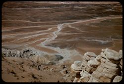
- Description:
- 25 f 11 pola
- Subject:
- Petrified Forest National Park (Ariz.), National parks & reserves, Deserts, Canyons, Hills, Cliffs, Shrubs, Boulders, Rocks, Rock formations, Mesas, Petr...
- Series:
- 17-52
- Creator:
- Cushman, Charles W., 1896-1972
- Date Created:
- 1952-04-13
- Genre:
- Landscape photographs
- Frame Number:
- 36
- County:
- Apache
- Abstract:
- In Blue Forest 113737
- Call Number:
- P06128
- Country:
- United States
- State/Province:
- Arizona
- Alternate Identifier:
- 1752.36
- Persistent URL:
- http://purl.dlib.indiana.edu/iudl/archives/cushman/P06128
- Holding Location:
- Bloomington - University Archives
Wells Library E460
1320 E 10th St.
Bloomington, IN 47405
Contact at archives@indiana.edu, 812-855-1127
-
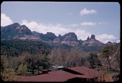
- Description:
- 25 f 11
- Subject:
- Canyons, Cliffs, Trees, Mountains, Shrubs, Clouds, Hills, Oak Creek Canyon (Ariz.), and Rock formations
- Series:
- 16-52
- Creator:
- Cushman, Charles W., 1896-1972
- Date Created:
- 1952-04-12
- Genre:
- Landscape photographs
- Frame Number:
- 29
- County:
- Coconino
- Abstract:
- Green pyramid
- Call Number:
- P06087
- Country:
- United States
- State/Province:
- Arizona
- Alternate Identifier:
- 1652.29
- Persistent URL:
- http://purl.dlib.indiana.edu/iudl/archives/cushman/P06087
- Holding Location:
- Bloomington - University Archives
Wells Library E460
1320 E 10th St.
Bloomington, IN 47405
Contact at archives@indiana.edu, 812-855-1127
-
- Description:
- 25 f 11 pola
- Subject:
- Blue Mesa (Ariz.), Canyons, Petrified forests, Cliffs, Mesas, Shadows, Mountains, Rock formations, Hills, Petrified Forest National Park (Ariz.), National pa...
- Series:
- 17-52
- Creator:
- Cushman, Charles W., 1896-1972
- Date Created:
- 1952-04-13
- Genre:
- Landscape photographs
- Frame Number:
- 35
- County:
- Apache
- Abstract:
- In Blue Forest 113737
- Call Number:
- P06127
- Country:
- United States
- State/Province:
- Arizona
- Alternate Identifier:
- 1752.35
- Persistent URL:
- http://purl.dlib.indiana.edu/iudl/archives/cushman/P06127
- Holding Location:
- Bloomington - University Archives
Wells Library E460
1320 E 10th St.
Bloomington, IN 47405
Contact at archives@indiana.edu, 812-855-1127
-
- Description:
- 25 f 10
- Subject:
- Canyons, Trees, Tree limbs, Mountains, Buildings, Rock formations, Hills, and Oak Creek Canyon (Ariz.)
- Series:
- 16-52
- Creator:
- Cushman, Charles W., 1896-1972
- Date Created:
- 1952-04-12
- Genre:
- Landscape photographs
- Frame Number:
- 27
- County:
- Coconino
- Abstract:
- Red monuments Spots
- Call Number:
- P06085
- Country:
- United States
- State/Province:
- Arizona
- Alternate Identifier:
- 1652.27
- Persistent URL:
- http://purl.dlib.indiana.edu/iudl/archives/cushman/P06085
- Holding Location:
- Bloomington - University Archives
Wells Library E460
1320 E 10th St.
Bloomington, IN 47405
Contact at archives@indiana.edu, 812-855-1127
-
- Description:
- 25 f 8 Pola
- Subject:
- Canyons, Cliffs, Trees, Bandelier National Monument (N.M.), Mountains, Rock formations, Hills, National parks & reserves, and Shrubs
- Series:
- 18-52
- Creator:
- Cushman, Charles W., 1896-1972
- Date Created:
- 1952-04-15
- Genre:
- Landscape photographs
- Frame Number:
- 25
- Street Address:
- New Mexico State Highway 4
- Abstract:
- View up a canyon (along NM 4).
- Call Number:
- P06155
- Country:
- United States
- State/Province:
- New Mexico
- Alternate Identifier:
- 1852.25
- Persistent URL:
- http://purl.dlib.indiana.edu/iudl/archives/cushman/P06155
- Holding Location:
- Bloomington - University Archives
Wells Library E460
1320 E 10th St.
Bloomington, IN 47405
Contact at archives@indiana.edu, 812-855-1127
-
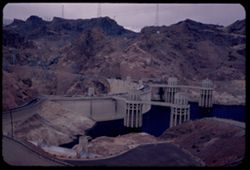
- Description:
- 25 f 5.6
- Subject:
- Towers, Hydraulic facilities, Canyons, Boulder Canyon (Ariz. and Nev.), Roads, Hydroelectric power, Hoover Dam (Ariz. and Nev.), Mountains, Lakes & pond...
- Series:
- 16-52
- Creator:
- Cushman, Charles W., 1896-1972
- Date Created:
- 1952-04-10
- Genre:
- Snapshots and Views
- Frame Number:
- 10
- Abstract:
- The Dam above on Arizona side
- Call Number:
- P06068
- Country:
- United States
- State/Province:
- Arizona
- Alternate Identifier:
- 1652.10
- Persistent URL:
- http://purl.dlib.indiana.edu/iudl/archives/cushman/P06068
- Holding Location:
- Bloomington - University Archives
Wells Library E460
1320 E 10th St.
Bloomington, IN 47405
Contact at archives@indiana.edu, 812-855-1127
-
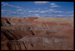
- Description:
- 50 f 11
- Subject:
- Deserts, Canyons, Buildings, Clouds, Hills, Painted Desert (Ariz.), and Valleys
- Series:
- 17-52
- Creator:
- Cushman, Charles W., 1896-1972
- Date Created:
- 1952-04-12
- Genre:
- Landscape photographs
- Frame Number:
- 6
- County:
- Navajo and Coconimo
- Abstract:
- View east from inside
- Call Number:
- P06100
- City:
- Holbrook
- Country:
- United States
- State/Province:
- Arizona
- Physical Description:
- Image was originally mounted in a glass enclosure. Before digitization, the image was removed and placed in a Wess Plastic, Inc. brand, 2" x 2", pl...
- Alternate Identifier:
- 1752.6
- Persistent URL:
- http://purl.dlib.indiana.edu/iudl/archives/cushman/P06100
- Holding Location:
- Bloomington - University Archives
Wells Library E460
1320 E 10th St.
Bloomington, IN 47405
Contact at archives@indiana.edu, 812-855-1127
-
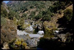
- Description:
- 25 f 8
- Subject:
- Rocks, Canyons, Roads, Trees, Stanislaus River (Calif.), Shrubs, Bridges, Hills, Rivers, and Rapids
- Series:
- 13-52
- Creator:
- Cushman, Charles W., 1896-1972
- Date Created:
- 1952-04-05
- Genre:
- Landscape photographs
- Frame Number:
- 21
- County:
- Tuolumne
- Abstract:
- Looking down into Stanislaus river canyon.
- Call Number:
- P05966
- City:
- Columbia
- Country:
- United States
- State/Province:
- California
- Alternate Identifier:
- 1352.21
- Persistent URL:
- http://purl.dlib.indiana.edu/iudl/archives/cushman/P05966
- Holding Location:
- Bloomington - University Archives
Wells Library E460
1320 E 10th St.
Bloomington, IN 47405
Contact at archives@indiana.edu, 812-855-1127
-
- Description:
- 25 f 9 Pola
- Subject:
- Deserts, Valleys, Mountains, Death Valley (Calif. and Nev.), Canyons, Hills, and Desolation Canyon (Calif.)
- Series:
- 15-52
- Creator:
- Cushman, Charles W., 1896-1972
- Date Created:
- 1952-04-09
- Genre:
- Landscape photographs
- Frame Number:
- 20
- County:
- Inyo
- Abstract:
- From road to Bad Water toward Desolation Canyon.
- Call Number:
- P06040
- City:
- Furnace Creek and Badwater
- Country:
- United States
- State/Province:
- California
- Alternate Identifier:
- 1552.20
- Persistent URL:
- http://purl.dlib.indiana.edu/iudl/archives/cushman/P06040
- Holding Location:
- Bloomington - University Archives
Wells Library E460
1320 E 10th St.
Bloomington, IN 47405
Contact at archives@indiana.edu, 812-855-1127
-
- Description:
- 50 f 8
- Subject:
- Canyons, Grasses, Cliffs, Trees, Red Canyon (Garfield County, Colo.), Tree limbs, Mountains, Rock formations, Clouds, and Hills
- Series:
- 9-53
- Creator:
- Cushman, Charles W., 1896-1972
- Date Created:
- 1953-10-13
- Genre:
- Landscape photographs
- Frame Number:
- 38
- County:
- Garfield
- Abstract:
- Red Canyon, south of Glenwood Spgs.
- Call Number:
- P06839
- City:
- Glenwood Springs
- Country:
- United States
- State/Province:
- Colorado
- Alternate Identifier:
- 953.38
- Persistent URL:
- http://purl.dlib.indiana.edu/iudl/archives/cushman/P06839
- Holding Location:
- Bloomington - University Archives
Wells Library E460
1320 E 10th St.
Bloomington, IN 47405
Contact at archives@indiana.edu, 812-855-1127
-
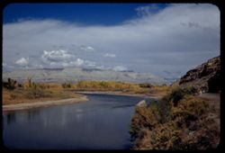
- Description:
- 50 f 8 Pola
- Subject:
- Rocks, Canyons, Grasses, Roads, Automobiles, Mesas, Colorado River (Colo.-Mexico), Mountains, Shrubs, Clouds, Hills, Rivers, and Trees
- Series:
- 9-53
- Creator:
- Cushman, Charles W., 1896-1972
- Date Created:
- 1953-10-12
- Genre:
- Landscape photographs
- Frame Number:
- 34
- County:
- Mesa
- Abstract:
- View north up river around bend
- Call Number:
- P06835
- City:
- Grand Junction
- Country:
- United States
- State/Province:
- Colorado
- Alternate Identifier:
- 953.34
- Persistent URL:
- http://purl.dlib.indiana.edu/iudl/archives/cushman/P06835
- Holding Location:
- Bloomington - University Archives
Wells Library E460
1320 E 10th St.
Bloomington, IN 47405
Contact at archives@indiana.edu, 812-855-1127
-
- Description:
- 50 f 11
- Subject:
- Canyons, Hills, Roads, Mountains, Shrubs, Rocks, Colorado River (Colo.-Mexico), Grasses, Mesas, Horseshoe Canyon (Colo.), Clouds, and Rivers
- Series:
- 9-53
- Creator:
- Cushman, Charles W., 1896-1972
- Date Created:
- 1953-10-12
- Genre:
- Landscape photographs
- Frame Number:
- 33
- County:
- Mesa
- Abstract:
- Colorado river in Horseshoe Canyon
- Call Number:
- P06834
- City:
- Grand Junction
- Country:
- United States
- State/Province:
- Colorado
- Alternate Identifier:
- 953.33
- Persistent URL:
- http://purl.dlib.indiana.edu/iudl/archives/cushman/P06834
- Holding Location:
- Bloomington - University Archives
Wells Library E460
1320 E 10th St.
Bloomington, IN 47405
Contact at archives@indiana.edu, 812-855-1127
-
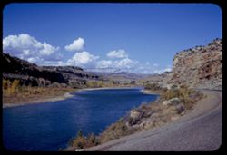
- Description:
- 50 f 11
- Subject:
- Rocks, Canyons, Grasses, Colorado River (Colo.-Mexico), Horseshoe Canyon (Colo.), Mountains, Shrubs, Clouds, Hills, and Rivers
- Series:
- 9-53
- Creator:
- Cushman, Charles W., 1896-1972
- Date Created:
- 1953-10-12
- Genre:
- Landscape photographs
- Frame Number:
- 29
- County:
- Mesa
- Abstract:
- Up and [?]on the Colorado river from top of horseshoe canyon on curve 28 miles east of Grand Junction
- Call Number:
- P06830
- City:
- Grand Junction
- Country:
- United States
- State/Province:
- Colorado
- Alternate Identifier:
- 953.29
- Persistent URL:
- http://purl.dlib.indiana.edu/iudl/archives/cushman/P06830
- Holding Location:
- Bloomington - University Archives
Wells Library E460
1320 E 10th St.
Bloomington, IN 47405
Contact at archives@indiana.edu, 812-855-1127
-
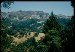
- Description:
- 50 f 9
- Subject:
- Canyons, Trees, Mountains, Shrubs, Sugarloaf Mountain (Napa County, Calif.), and Hills
- Series:
- 4-54
- Creator:
- Cushman, Charles W., 1896-1972
- Date Created:
- 1954-08-13
- Genre:
- Landscape photographs
- Frame Number:
- 16
- Street Address:
- California State Highway 29
- County:
- Napa
- Abstract:
- Toward Sugarloaf Mtn from Cal Hwy 29 ne of Calistoga- across deep canyon
- Call Number:
- P07190
- City:
- Calistoga
- Country:
- United States
- State/Province:
- California
- Physical Description:
- Anscochrome film.
- Alternate Identifier:
- 454.16
- Persistent URL:
- http://purl.dlib.indiana.edu/iudl/archives/cushman/P07190
- Holding Location:
- Bloomington - University Archives
Wells Library E460
1320 E 10th St.
Bloomington, IN 47405
Contact at archives@indiana.edu, 812-855-1127
-
- Description:
- 50 f 8
- Subject:
- Canyons, Feather River (Calif.), Trees, Shrubs, Feather River Inn (Cromberg, Calif.), Hills, Rivers, and Feather River Canyon (Calif.)
- Series:
- 14-54
- Creator:
- Cushman, Charles W., 1896-1972
- Date Created:
- 1954-10-10
- Genre:
- Landscape photographs
- Frame Number:
- 27
- County:
- Plumas
- Abstract:
- View westward down Feather river canyon 2 mi. w. of Feather river Inn.
- Call Number:
- P07468
- City:
- Cromberg
- Country:
- United States
- State/Province:
- California
- Alternate Identifier:
- 1454.27
- Persistent URL:
- http://purl.dlib.indiana.edu/iudl/archives/cushman/P07468
- Holding Location:
- Bloomington - University Archives
Wells Library E460
1320 E 10th St.
Bloomington, IN 47405
Contact at archives@indiana.edu, 812-855-1127
-
- Description:
- 50 f 8
- Subject:
- Rocks, Canyons, Feather River (Calif.), Trees, Shrubs, Hills, and Rivers
- Series:
- 15-54
- Creator:
- Cushman, Charles W., 1896-1972
- Date Created:
- 1954-10-11
- Genre:
- Landscape photographs
- Frame Number:
- 11
- County:
- Butte
- Abstract:
- View from bridge over lovely stream (west branch Feather) below a wretched road.
- Call Number:
- P07490
- Country:
- United States
- State/Province:
- California
- Alternate Identifier:
- 1554.11
- Persistent URL:
- http://purl.dlib.indiana.edu/iudl/archives/cushman/P07490
- Holding Location:
- Bloomington - University Archives
Wells Library E460
1320 E 10th St.
Bloomington, IN 47405
Contact at archives@indiana.edu, 812-855-1127
-
- Description:
- 50 f 10
- Subject:
- Rocks, Road cuts, Canyons, Roads, Feather River (Calif.), Trees, Shrubs, and Hills
- Series:
- 15-54
- Creator:
- Cushman, Charles W., 1896-1972
- Date Created:
- 1954-10-11
- Genre:
- Landscape photographs
- Frame Number:
- 6
- Street Address:
- United States Highway 40
- County:
- Butte
- Abstract:
- View No. on US 40 Alt.
- Call Number:
- P07485
- City:
- Pulga
- Country:
- United States
- State/Province:
- California
- Alternate Identifier:
- 1554.6
- Persistent URL:
- http://purl.dlib.indiana.edu/iudl/archives/cushman/P07485
- Holding Location:
- Bloomington - University Archives
Wells Library E460
1320 E 10th St.
Bloomington, IN 47405
Contact at archives@indiana.edu, 812-855-1127
-
- Description:
- 50 f 6.3
- Subject:
- Western Pacific Railroad Company, Canyons, Hills, Settlements, Shrubs, Trees, Feather River (Calif.), Houses, and Dwellings
- Series:
- 14-54
- Creator:
- Cushman, Charles W., 1896-1972
- Date Created:
- 1954-10-10
- Genre:
- Landscape photographs
- Frame Number:
- 30
- Street Address:
- United States Highway 40
- County:
- Plumas
- Abstract:
- Across the deep ravine between Hwy US Alt 40 to the WP + the little town of Keddie.
- Call Number:
- P07471
- City:
- Keddie
- Country:
- United States
- State/Province:
- California
- Physical Description:
- Image was originally mounted in a glass enclosure. Before digitization, the image was removed and placed in a Wess Plastic, Inc. brand, 2" x 2", pl...
- Alternate Identifier:
- 1454.30
- Persistent URL:
- http://purl.dlib.indiana.edu/iudl/archives/cushman/P07471
- Holding Location:
- Bloomington - University Archives
Wells Library E460
1320 E 10th St.
Bloomington, IN 47405
Contact at archives@indiana.edu, 812-855-1127
-
- Description:
- 50 f 8
- Subject:
- Canyons, Valleys, Hills, Saratoga Gap (Calif.), Fog, Santa Clara Valley (Santa Clara County, Calif.), Trees, and Clouds
- Series:
- 17-54
- Creator:
- Cushman, Charles W., 1896-1972
- Date Created:
- 1954-11-19
- Genre:
- Landscape photographs
- Frame Number:
- 9
- County:
- Santa Clara
- Abstract:
- heavy smoke fog bank over Santa Clara Valley from Saratoga Gap
- Call Number:
- P07529
- Country:
- United States
- State/Province:
- California
- Physical Description:
- Anscochrome film.
- Alternate Identifier:
- 1754.9
- Persistent URL:
- http://purl.dlib.indiana.edu/iudl/archives/cushman/P07529
- Holding Location:
- Bloomington - University Archives
Wells Library E460
1320 E 10th St.
Bloomington, IN 47405
Contact at archives@indiana.edu, 812-855-1127
-
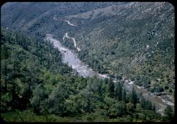
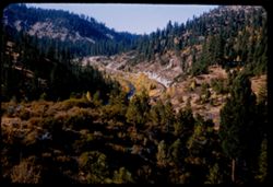
- Description:
- 50 f 8
- Subject:
- Canyons, Feather River (Calif.), Trees, Western Pacific Railroad Company, Shrubs, Rapids, Feather River Canyon (Calif.), Hills, Railroads, and Rivers
- Series:
- 14-54
- Creator:
- Cushman, Charles W., 1896-1972
- Date Created:
- 1954-10-11
- Genre:
- Landscape photographs
- Frame Number:
- 35
- County:
- Butte
- Abstract:
- View up Feather river canyon from Jarbo Pass. ["Jarbo Pass" is scratched out]
- Call Number:
- P07475
- City:
- Jarbo Gap
- Country:
- United States
- State/Province:
- California
- Alternate Identifier:
- 1454.35
- Persistent URL:
- http://purl.dlib.indiana.edu/iudl/archives/cushman/P07475
- Holding Location:
- Bloomington - University Archives
Wells Library E460
1320 E 10th St.
Bloomington, IN 47405
Contact at archives@indiana.edu, 812-855-1127
-
- Description:
- 50 f 8
- Subject:
- Rocks, Canyons, Feather River (Calif.), Trees, Western Pacific Railroad Company, Shrubs, Rapids, Feather River Canyon (Calif.), Hills, Railroads, and Rivers
- Series:
- 14-54
- Creator:
- Cushman, Charles W., 1896-1972
- Date Created:
- 1954-10-11
- Genre:
- Landscape photographs
- Frame Number:
- 36
- County:
- Butte
- Abstract:
- View up Feather river near Big Bend.
- Call Number:
- P07476
- City:
- Big Bend
- Country:
- United States
- State/Province:
- California
- Alternate Identifier:
- 1454.36
- Persistent URL:
- http://purl.dlib.indiana.edu/iudl/archives/cushman/P07476
- Holding Location:
- Bloomington - University Archives
Wells Library E460
1320 E 10th St.
Bloomington, IN 47405
Contact at archives@indiana.edu, 812-855-1127
-
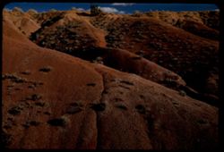
- Description:
- 100 f 8 tl
- Subject:
- Twenty Mule Team Canyon (Calif.), Valleys, Rock formations, Death Valley National Park (Calif. and Nev.), Hills, and Canyons
- Series:
- 10-55
- Creator:
- Cushman, Charles W., 1896-1972
- Date Created:
- 1955-03-23
- Genre:
- Landscape photographs
- Frame Number:
- 38
- County:
- Inyo
- Abstract:
- In 20 Mule Team canyon
- Call Number:
- P07862
- Country:
- United States
- State/Province:
- California
- Physical Description:
- masked.
- Alternate Identifier:
- 1055.38
- Persistent URL:
- http://purl.dlib.indiana.edu/iudl/archives/cushman/P07862
- Holding Location:
- Bloomington - University Archives
Wells Library E460
1320 E 10th St.
Bloomington, IN 47405
Contact at archives@indiana.edu, 812-855-1127
-
- Description:
- 100 f 5.6 tl
- Subject:
- Redwood Creek Valley (Humboldt County, Calif.), Canyons, Valleys, Hills, Roads, Mountains, Dwellings, Trees, and Berry Summit (Calif.)
- Series:
- 16-55
- Creator:
- Cushman, Charles W., 1896-1972
- Date Created:
- 1955-06-15
- Genre:
- Landscape photographs
- Frame Number:
- 11
- County:
- Humboldt
- Abstract:
- From higher up same road at 65434 mi. about 2 mi. below Berry Summit - view across canyon of redwood Creek approx ...
- Call Number:
- P08055
- Country:
- United States
- State/Province:
- California
- Alternate Identifier:
- 1655.11
- Persistent URL:
- http://purl.dlib.indiana.edu/iudl/archives/cushman/P08055
- Holding Location:
- Bloomington - University Archives
Wells Library E460
1320 E 10th St.
Bloomington, IN 47405
Contact at archives@indiana.edu, 812-855-1127
-
- Description:
- 100 f 4.5 tl
- Subject:
- Canyons, Hills, Roads, Rocks, Clouds, and Kern River Valley (Calif.)
- Series:
- 2-55
- Creator:
- Cushman, Charles W., 1896-1972
- Date Created:
- 1955-02-26
- Genre:
- Landscape photographs
- Frame Number:
- 5
- Street Address:
- California State Highway 178
- County:
- Kern
- Abstract:
- View up canyon
- Call Number:
- P07563
- City:
- Bakersfield
- Country:
- United States
- State/Province:
- California
- Alternate Identifier:
- 255.5
- Persistent URL:
- http://purl.dlib.indiana.edu/iudl/archives/cushman/P07563
- Holding Location:
- Bloomington - University Archives
Wells Library E460
1320 E 10th St.
Bloomington, IN 47405
Contact at archives@indiana.edu, 812-855-1127
-
- Description:
- 100 f 8 TL
- Subject:
- Valleys, Mustang Ridge (Monterey County, Calif.), Mountains, Hills, Peachtree Valley (Calif.), and Canyons
- Series:
- 6-56
- Creator:
- Cushman, Charles W., 1896-1972
- Date Created:
- 1956-04-21
- Genre:
- Landscape photographs
- Frame Number:
- 3
- Street Address:
- California State Highway 198
- County:
- Monterey
- Abstract:
- View northward across deep (peach tree Valley) from 198 - 13 mi. east of San Lucas toward Mustang Ridge
- Call Number:
- P08713
- City:
- San Lucas
- Country:
- United States
- State/Province:
- California
- Alternate Identifier:
- 656.3
- Persistent URL:
- http://purl.dlib.indiana.edu/iudl/archives/cushman/P08713
- Holding Location:
- Bloomington - University Archives
Wells Library E460
1320 E 10th St.
Bloomington, IN 47405
Contact at archives@indiana.edu, 812-855-1127
-
- Description:
- 100 f 8 TL
- Subject:
- Valleys, Trees, Hills, and Canyons
- Series:
- 6-56
- Creator:
- Cushman, Charles W., 1896-1972
- Date Created:
- 1956-04-21
- Genre:
- Landscape photographs
- Frame Number:
- 6
- Street Address:
- California State Highway 198 and Peach Tree Road
- Abstract:
- Green gullied hills ne of and above Peach Tree Rd.
- Call Number:
- P08716
- Country:
- United States
- State/Province:
- California
- Alternate Identifier:
- 656.6
- Persistent URL:
- http://purl.dlib.indiana.edu/iudl/archives/cushman/P08716
- Holding Location:
- Bloomington - University Archives
Wells Library E460
1320 E 10th St.
Bloomington, IN 47405
Contact at archives@indiana.edu, 812-855-1127
-

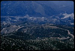
- Description:
- 100 f 5.6 tl
- Subject:
- Canyons, Hills, Mountains, and Cajon Canyon (Calif.)
- Series:
- 6-57
- Creator:
- Cushman, Charles W., 1896-1972
- Date Created:
- 1957-05-14
- Genre:
- Landscape photographs
- Frame Number:
- 35
- County:
- San Bernardino
- Abstract:
- In Cajon Canyon
- Call Number:
- P09277
- Country:
- United States
- State/Province:
- California
- Alternate Identifier:
- 657.35
- Persistent URL:
- http://purl.dlib.indiana.edu/iudl/archives/cushman/P09277
- Holding Location:
- Bloomington - University Archives
Wells Library E460
1320 E 10th St.
Bloomington, IN 47405
Contact at archives@indiana.edu, 812-855-1127
-
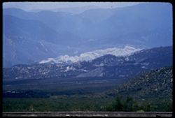
- Description:
- 100 f 6.3 tl ?
- Subject:
- Valleys, Cajon Canyon (Calif.), Mountains, Hills, Mists, Canyons, and Cajon Pass (Calif.)
- Series:
- 7-57
- Creator:
- Cushman, Charles W., 1896-1972
- Date Created:
- 1957-05-14
- Genre:
- Landscape photographs
- Frame Number:
- 4
- Street Address:
- United States Highway 66
- County:
- San Bernardino
- Abstract:
- View SW & W from high point on US 66 through Cajon Pass (4255') Toward mountains to soufh
- Call Number:
- P09283
- Country:
- United States
- State/Province:
- California
- Alternate Identifier:
- 757.4
- Persistent URL:
- http://purl.dlib.indiana.edu/iudl/archives/cushman/P09283
- Holding Location:
- Bloomington - University Archives
Wells Library E460
1320 E 10th St.
Bloomington, IN 47405
Contact at archives@indiana.edu, 812-855-1127
-
- Description:
- 100 f 8 tl
- Subject:
- Canyons, Cajon Canyon (Calif.), Mountains, Hills, and Cajon Pass (Calif.)
- Series:
- 7-57
- Creator:
- Cushman, Charles W., 1896-1972
- Date Created:
- 1957-05-14
- Genre:
- Landscape photographs
- Frame Number:
- 8
- County:
- San Bernardino
- Abstract:
- View down SE from Cajon summit of 4255' after lunch
- Call Number:
- P09287
- Country:
- United States
- State/Province:
- California
- Alternate Identifier:
- 757.8
- Persistent URL:
- http://purl.dlib.indiana.edu/iudl/archives/cushman/P09287
- Holding Location:
- Bloomington - University Archives
Wells Library E460
1320 E 10th St.
Bloomington, IN 47405
Contact at archives@indiana.edu, 812-855-1127
-
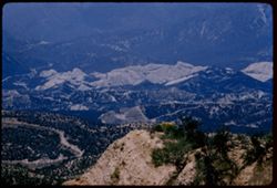
- Description:
- 100 f 8 tl
- Subject:
- Canyons, Cajon Canyon (Calif.), Roads, Mountains, Hills, and Cajon Pass (Calif.)
- Series:
- 7-57
- Creator:
- Cushman, Charles W., 1896-1972
- Date Created:
- 1957-05-14
- Genre:
- Landscape photographs
- Frame Number:
- 3
- Street Address:
- United States Highway 66
- County:
- San Bernardino
- Abstract:
- View SW & W from high point on US 66 through Cajon Pass (4255') Down into Cajon canyon
- Call Number:
- P09282
- Country:
- United States
- State/Province:
- California
- Alternate Identifier:
- 957.3
- Persistent URL:
- http://purl.dlib.indiana.edu/iudl/archives/cushman/P09282
- Holding Location:
- Bloomington - University Archives
Wells Library E460
1320 E 10th St.
Bloomington, IN 47405
Contact at archives@indiana.edu, 812-855-1127
-
- Description:
- 100 f 5.6 tl
- Subject:
- Canyons, Cajon Canyon (Calif.), Mountains, Rock formations, Hills, Valleys, and Cajon Pass (Calif.)
- Series:
- 7-57
- Creator:
- Cushman, Charles W., 1896-1972
- Date Created:
- 1957-05-14
- Genre:
- Landscape photographs
- Frame Number:
- 9
- County:
- San Bernardino
- Abstract:
- View down from 4000 ft. on sw grade of Cajon Pass
- Call Number:
- P09288
- Country:
- United States
- State/Province:
- California
- Alternate Identifier:
- 757.9
- Persistent URL:
- http://purl.dlib.indiana.edu/iudl/archives/cushman/P09288
- Holding Location:
- Bloomington - University Archives
Wells Library E460
1320 E 10th St.
Bloomington, IN 47405
Contact at archives@indiana.edu, 812-855-1127
-
- Description:
- 100 f 6.3 or 8 tl
- Subject:
- Canyons, Cajon Canyon (Calif.), Cliffs, Mountains, Rock formations, Hills, and Cajon Pass (Calif.)
- Series:
- 7-57
- Creator:
- Cushman, Charles W., 1896-1972
- Date Created:
- 1957-05-14
- Genre:
- Landscape photographs
- Frame Number:
- 2
- Street Address:
- United States Highway 66
- County:
- San Bernardino
- Abstract:
- View SW & W from high point on US 66 through Cajon Pass (4255') Down into Cajon Canyon
- Call Number:
- P09281
- Country:
- United States
- State/Province:
- California
- Alternate Identifier:
- 757.2
- Persistent URL:
- http://purl.dlib.indiana.edu/iudl/archives/cushman/P09281
- Holding Location:
- Bloomington - University Archives
Wells Library E460
1320 E 10th St.
Bloomington, IN 47405
Contact at archives@indiana.edu, 812-855-1127
-
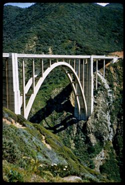
- Description:
- 100 f 4 sl
- Subject:
- Canyons, Arches, Mountains, Bixby Bridge (Calif.), Bridges, Hills, and Bixby Creek (Calif.)
- Series:
- 5-57
- Creator:
- Cushman, Charles W., 1896-1972
- Date Created:
- 1957-05-09
- Genre:
- Architectural photographs
- Frame Number:
- 20
- Street Address:
- California Highway 1 and Pacific Coast Highway
- County:
- Monterey
- Abstract:
- Bixby Creek Concrete Arch Bridge [P]
- Call Number:
- P09225
- Country:
- United States
- State/Province:
- California
- Alternate Identifier:
- 557.20
- Persistent URL:
- http://purl.dlib.indiana.edu/iudl/archives/cushman/P09225
- Holding Location:
- Bloomington - University Archives
Wells Library E460
1320 E 10th St.
Bloomington, IN 47405
Contact at archives@indiana.edu, 812-855-1127