
Search Constraints
You searched for:
Campus
IUB
Remove constraint Campus: IUB
Subject
Hills
Remove constraint Subject: Hills
State/Province
Nevada
Remove constraint State/Province: Nevada
1 - 43 of 43
Search Results
-
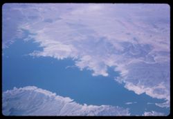
- Subject:
- Lakes & ponds, Deserts, Hills, Mead, Lake (Ariz. and Nev.), Coastlines, and Air travel
- Series:
- 1-65
- Creator:
- Cushman, Charles W., 1896-1972
- Date Created:
- 1965-03-30
- Genre:
- Aerial photographs and Landscape photographs
- Frame Number:
- 18
- Call Number:
- P13882
- Country:
- United States
- State/Province:
- Nevada and Arizona
- Alternate Identifier:
- 165.18
- Persistent URL:
- http://purl.dlib.indiana.edu/iudl/archives/cushman/P13882
- Holding Location:
- Bloomington - University Archives
Wells Library E460
1320 E 10th St.
Bloomington, IN 47405
Contact at archives@indiana.edu, 812-855-1127
-
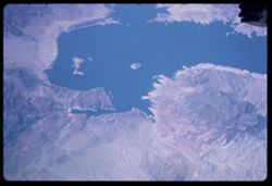
- Subject:
- Lakes & ponds, Deserts, Hills, Mead, Lake (Ariz. and Nev.), Coastlines, Rivers, and Air travel
- Series:
- 1-65
- Creator:
- Cushman, Charles W., 1896-1972
- Date Created:
- 1965-03-30
- Genre:
- Aerial photographs and Landscape photographs
- Frame Number:
- 17
- Call Number:
- P13881
- Country:
- United States
- State/Province:
- Nevada and Arizona
- Alternate Identifier:
- 165.17
- Persistent URL:
- http://purl.dlib.indiana.edu/iudl/archives/cushman/P13881
- Holding Location:
- Bloomington - University Archives
Wells Library E460
1320 E 10th St.
Bloomington, IN 47405
Contact at archives@indiana.edu, 812-855-1127
-
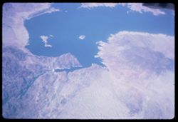
- Description:
- 200 f 8
- Subject:
- Deserts, Mead, Lake (Ariz. and Nev.), Coastlines, Pan American World Airways, inc., Air travel, Lakes & ponds, Hills, and Rivers
- Series:
- 1-65
- Creator:
- Cushman, Charles W., 1896-1972
- Date Created:
- 1965-03-30
- Genre:
- Aerial photographs and Landscape photographs
- Frame Number:
- 16
- Call Number:
- P13880
- Country:
- United States
- State/Province:
- Arizona and Nevada
- Alternate Identifier:
- 165.16
- Persistent URL:
- http://purl.dlib.indiana.edu/iudl/archives/cushman/P13880
- Holding Location:
- Bloomington - University Archives
Wells Library E460
1320 E 10th St.
Bloomington, IN 47405
Contact at archives@indiana.edu, 812-855-1127
-
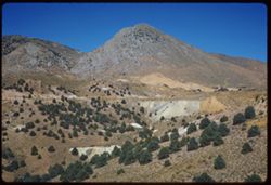
- Description:
- 100 f 6.3 SL
- Subject:
- Grasses, Houses, Churches, Shrubs, Hills, Utility poles, Roads, and Buildings
- Series:
- 3-62
- Creator:
- Cushman, Charles W., 1896-1972
- Date Created:
- 1962-09-29
- Genre:
- Landscape photographs and Cityscape photographs
- Frame Number:
- 24
- County:
- Storey
- Abstract:
- Virginia Cy.
- Call Number:
- P12881
- City:
- Virginia City
- Country:
- United States
- State/Province:
- Nevada
- Alternate Identifier:
- 362.24
- Persistent URL:
- http://purl.dlib.indiana.edu/iudl/archives/cushman/P12881
- Holding Location:
- Bloomington - University Archives
Wells Library E460
1320 E 10th St.
Bloomington, IN 47405
Contact at archives@indiana.edu, 812-855-1127
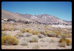
-
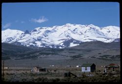
- Description:
- 100 f 11 TL
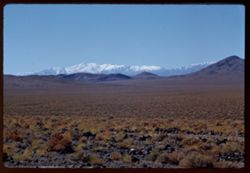
- Subject:
- Snow, Houses, Mountains, Fences, and Hills
- Series:
- 2-63
- Creator:
- Cushman, Charles W., 1896-1972
- Date Created:
- 1963-05-08
- Genre:
- Landscape photographs
- Frame Number:
- 1
- County:
- Elko
- Abstract:
- Mtn. South of Wells
- Call Number:
- P12826
- City:
- Wells
- Country:
- United States
- State/Province:
- Nevada
- Alternate Identifier:
- 263.1
- Persistent URL:
- http://purl.dlib.indiana.edu/iudl/archives/cushman/P12826
- Holding Location:
- Bloomington - University Archives
Wells Library E460
1320 E 10th St.
Bloomington, IN 47405
Contact at archives@indiana.edu, 812-855-1127
-
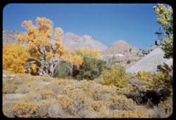
- Description:
- 50 f 9 SL
- Subject:
- Hills, Mountains, Rock formations, and Grasses
- Series:
- 4-62
- Creator:
- Cushman, Charles W., 1896-1972
- Date Created:
- 1962-09-30
- Genre:
- Landscape photographs
- Frame Number:
- 7
- County:
- Nye
- Abstract:
- Beatty, Nevada.
- Call Number:
- P12736
- City:
- Beatty
- Country:
- United States
- State/Province:
- Nevada
- Physical Description:
- masked.
- Alternate Identifier:
- 462.7
- Persistent URL:
- http://purl.dlib.indiana.edu/iudl/archives/cushman/P12736
- Holding Location:
- Bloomington - University Archives
Wells Library E460
1320 E 10th St.
Bloomington, IN 47405
Contact at archives@indiana.edu, 812-855-1127
-
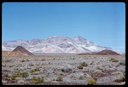
- Description:
- 100 f 8 TL
- Subject:
- Rock Candy Mountain (Calif.), Plains, Hills, Mountains, and Grasses
- Series:
- 3-62
- Creator:
- Cushman, Charles W., 1896-1972
- Date Created:
- 1962-09-30
- Genre:
- Landscape photographs
- Frame Number:
- 38
- County:
- Nye
- Abstract:
- Rock candy mountain along US 95, 24 mi. west of Tonopah.
- Call Number:
- P12735
- City:
- Tonopah
- Country:
- United States
- State/Province:
- Nevada
- Alternate Identifier:
- 362.38
- Persistent URL:
- http://purl.dlib.indiana.edu/iudl/archives/cushman/P12735
- Holding Location:
- Bloomington - University Archives
Wells Library E460
1320 E 10th St.
Bloomington, IN 47405
Contact at archives@indiana.edu, 812-855-1127
-
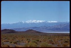
- Description:
- 100 f 8 TL
- Subject:
- Snow, Grasses, White Mountains (Calif. and Nev.), Plains, Mountains, and Hills
- Series:
- 3-62
- Creator:
- Cushman, Charles W., 1896-1972
- Date Created:
- 1962-09-30
- Genre:
- Landscape photographs
- Frame Number:
- 37
- Street Address:
- United States Highway 95
- County:
- Mineral
- Abstract:
- Snow-capped mtns SW of US 95.
- Call Number:
- P12734
- City:
- Mina
- Country:
- United States
- State/Province:
- Nevada
- Alternate Identifier:
- 362.37
- Persistent URL:
- http://purl.dlib.indiana.edu/iudl/archives/cushman/P12734
- Holding Location:
- Bloomington - University Archives
Wells Library E460
1320 E 10th St.
Bloomington, IN 47405
Contact at archives@indiana.edu, 812-855-1127
-
- Description:
- 100 f 8 TL
- Subject:
- Snow, Grasses, White Mountains (Calif. and Nev.), Plains, Mountains, and Hills
- Series:
- 3-62
- Creator:
- Cushman, Charles W., 1896-1972
- Date Created:
- 1962-09-30
- Genre:
- Landscape photographs
- Frame Number:
- 36
- Street Address:
- United States Highway 95
- County:
- Mineral
- Abstract:
- Snow-capped mtns SW of US 95.
- Call Number:
- P12733
- City:
- Mina
- Country:
- United States
- State/Province:
- Nevada
- Alternate Identifier:
- 362.36
- Persistent URL:
- http://purl.dlib.indiana.edu/iudl/archives/cushman/P12733
- Holding Location:
- Bloomington - University Archives
Wells Library E460
1320 E 10th St.
Bloomington, IN 47405
Contact at archives@indiana.edu, 812-855-1127
-
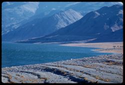
- Description:
- 100 f 8 TL
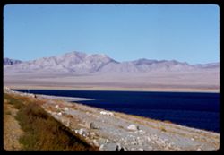
- Subject:
- Lakes & ponds, Hills, Mountains, Walker Lake (Nev. : Lake), Rocks, Coastlines, and Grasses
- Series:
- 3-62
- Creator:
- Cushman, Charles W., 1896-1972
- Date Created:
- 1962-09-29
- Genre:
- Landscape photographs
- Frame Number:
- 35
- County:
- Mineral
- Abstract:
- Walker Lake.
- Call Number:
- P12732
- Country:
- United States
- State/Province:
- Nevada
- Alternate Identifier:
- 362.35
- Persistent URL:
- http://purl.dlib.indiana.edu/iudl/archives/cushman/P12732
- Holding Location:
- Bloomington - University Archives
Wells Library E460
1320 E 10th St.
Bloomington, IN 47405
Contact at archives@indiana.edu, 812-855-1127
-
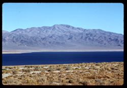
- Description:
- 100 f 6.3 TL
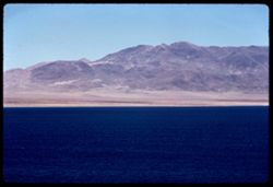
- Subject:
- Lakes & ponds, Hills, Mountains, Walker Lake (Nev. : Lake), and Coastlines
- Series:
- 3-62
- Creator:
- Cushman, Charles W., 1896-1972
- Date Created:
- 1962-09-29
- Genre:
- Landscape photographs
- Frame Number:
- 34
- County:
- Mineral
- Abstract:
- Walker Lake.
- Call Number:
- P12731
- Country:
- United States
- State/Province:
- Nevada
- Alternate Identifier:
- 362.34
- Persistent URL:
- http://purl.dlib.indiana.edu/iudl/archives/cushman/P12731
- Holding Location:
- Bloomington - University Archives
Wells Library E460
1320 E 10th St.
Bloomington, IN 47405
Contact at archives@indiana.edu, 812-855-1127
-
- Description:
- 100 f 8 TL
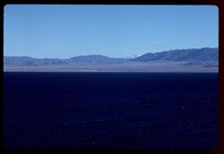
- Subject:
- Snow, Coastlines, Mountains, Walker Lake (Nev. : Lake), Lakes & ponds, and Hills
- Series:
- 3-62
- Creator:
- Cushman, Charles W., 1896-1972
- Date Created:
- 1962-09-29
- Genre:
- Landscape photographs
- Frame Number:
- 33
- County:
- Mineral
- Abstract:
- Walker Lake toward Mt.
- Call Number:
- P12730
- Country:
- United States
- State/Province:
- Nevada
- Alternate Identifier:
- 362.33
- Persistent URL:
- http://purl.dlib.indiana.edu/iudl/archives/cushman/P12730
- Holding Location:
- Bloomington - University Archives
Wells Library E460
1320 E 10th St.
Bloomington, IN 47405
Contact at archives@indiana.edu, 812-855-1127
-
- Description:
- 100 f 5.6 TL
- Subject:
- Lakes & ponds, Hills, Mountains, Walker Lake (Nev. : Lake), Rocks, and Coastlines
- Series:
- 3-62
- Creator:
- Cushman, Charles W., 1896-1972
- Date Created:
- 1962-09-29
- Genre:
- Landscape photographs
- Frame Number:
- 32
- County:
- Mineral
- Abstract:
- Walker Lake.
- Call Number:
- P12729
- Country:
- United States
- State/Province:
- Nevada
- Alternate Identifier:
- 362.32
- Persistent URL:
- http://purl.dlib.indiana.edu/iudl/archives/cushman/P12729
- Holding Location:
- Bloomington - University Archives
Wells Library E460
1320 E 10th St.
Bloomington, IN 47405
Contact at archives@indiana.edu, 812-855-1127
-
- Description:
- 100 f 8 TL
- Subject:
- Lakes & ponds, Hills, Mountains, Walker Lake (Nev. : Lake), Coastlines, and Grasses
- Series:
- 3-62
- Creator:
- Cushman, Charles W., 1896-1972
- Date Created:
- 1962-09-29
- Genre:
- Landscape photographs
- Frame Number:
- 31
- County:
- Mineral
- Abstract:
- Walker Lake.
- Call Number:
- P12728
- Country:
- United States
- State/Province:
- Nevada
- Alternate Identifier:
- 362.31
- Persistent URL:
- http://purl.dlib.indiana.edu/iudl/archives/cushman/P12728
- Holding Location:
- Bloomington - University Archives
Wells Library E460
1320 E 10th St.
Bloomington, IN 47405
Contact at archives@indiana.edu, 812-855-1127
-
- Description:
- 100 f 8 TL
- Subject:
- Rocks, Grasses, Mountains, Shrubs, and Hills
- Series:
- 3-62
- Creator:
- Cushman, Charles W., 1896-1972
- Date Created:
- 1962-09-29
- Genre:
- Landscape photographs
- Frame Number:
- 30
- County:
- Storey
- Abstract:
- View east from [dome]
- Call Number:
- P12727
- City:
- Virginia City
- Country:
- United States
- State/Province:
- Nevada
- Alternate Identifier:
- 362.30
- Persistent URL:
- http://purl.dlib.indiana.edu/iudl/archives/cushman/P12727
- Holding Location:
- Bloomington - University Archives
Wells Library E460
1320 E 10th St.
Bloomington, IN 47405
Contact at archives@indiana.edu, 812-855-1127
-
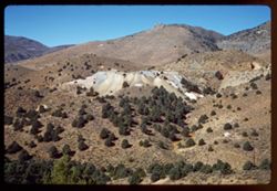
- Description:
- 100 f 6.3 SL
- Subject:
- Hills, Mining, Mountains, Trees, and Abandoned mines
- Series:
- 3-62
- Creator:
- Cushman, Charles W., 1896-1972
- Date Created:
- 1962-09-29
- Genre:
- Identification photographs and Landscape photographs
- Frame Number:
- 23
- County:
- Storey
- Abstract:
- Scene nearby.
- Call Number:
- P12721
- City:
- Virginia City
- Country:
- United States
- State/Province:
- Nevada
- Alternate Identifier:
- 362.23
- Persistent URL:
- http://purl.dlib.indiana.edu/iudl/archives/cushman/P12721
- Holding Location:
- Bloomington - University Archives
Wells Library E460
1320 E 10th St.
Bloomington, IN 47405
Contact at archives@indiana.edu, 812-855-1127
-
- Description:
- 100 f 8 SL
- Subject:
- Hills, Mining, Roads, Mountains, and Trees
- Series:
- 3-62
- Creator:
- Cushman, Charles W., 1896-1972
- Date Created:
- 1962-09-29
- Genre:
- Landscape photographs
- Frame Number:
- 22
- County:
- Storey
- Abstract:
- Toward Virginia Cy. from SE.
- Call Number:
- P12720
- City:
- Virginia City
- Country:
- United States
- State/Province:
- Nevada
- Alternate Identifier:
- 362.22
- Persistent URL:
- http://purl.dlib.indiana.edu/iudl/archives/cushman/P12720
- Holding Location:
- Bloomington - University Archives
Wells Library E460
1320 E 10th St.
Bloomington, IN 47405
Contact at archives@indiana.edu, 812-855-1127
-
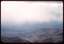
- Description:
- 100 f 4.5 TL
- Subject:
- Valleys, Mountains, Clouds, and Hills
- Series:
- 3-62
- Creator:
- Cushman, Charles W., 1896-1972
- Date Created:
- 1962-09-28
- Genre:
- Landscape photographs
- Frame Number:
- 21
- County:
- Washoe and Carson City
- Abstract:
- Pleasant Valley.
- Call Number:
- P12719
- City:
- Pleasant Valley, Carson City, and Reno
- Country:
- United States
- State/Province:
- Nevada
- Alternate Identifier:
- 362.21
- Persistent URL:
- http://purl.dlib.indiana.edu/iudl/archives/cushman/P12719
- Holding Location:
- Bloomington - University Archives
Wells Library E460
1320 E 10th St.
Bloomington, IN 47405
Contact at archives@indiana.edu, 812-855-1127
-
- Description:
- 100 f 8 TL
- Subject:
- Hills, Mountains, Shrubs, and Clouds
- Series:
- 3-62
- Creator:
- Cushman, Charles W., 1896-1972
- Date Created:
- 1962-09-28
- Genre:
- Landscape photographs
- Frame Number:
- 20
- County:
- Storey
- Abstract:
- View east from Va. Cy.
- Call Number:
- P12718
- City:
- Virginia City
- Country:
- United States
- State/Province:
- Nevada
- Alternate Identifier:
- 362.20
- Persistent URL:
- http://purl.dlib.indiana.edu/iudl/archives/cushman/P12718
- Holding Location:
- Bloomington - University Archives
Wells Library E460
1320 E 10th St.
Bloomington, IN 47405
Contact at archives@indiana.edu, 812-855-1127
-
- Description:
- 100 f 6.3 TL
- Subject:
- Roads, Mountains, Shrubs, Clouds, Hills, and Utility poles
- Series:
- 3-62
- Creator:
- Cushman, Charles W., 1896-1972
- Date Created:
- 1962-09-28
- Genre:
- Landscape photographs
- Frame Number:
- 19
- County:
- Storey
- Abstract:
- View east from Va. Cy.
- Call Number:
- P12717
- City:
- Virginia City
- Country:
- United States
- State/Province:
- Nevada
- Alternate Identifier:
- 362.19
- Persistent URL:
- http://purl.dlib.indiana.edu/iudl/archives/cushman/P12717
- Holding Location:
- Bloomington - University Archives
Wells Library E460
1320 E 10th St.
Bloomington, IN 47405
Contact at archives@indiana.edu, 812-855-1127
-
- Description:
- 50 f 4 TL
- Subject:
- Tree limbs, Hills, Windows, Silver City (Nev.), Shrubs, Trees, Rocks, Grasses, Doors & doorways, and Buildings
- Series:
- 3-62
- Creator:
- Cushman, Charles W., 1896-1972
- Date Created:
- 1962-09-28
- Genre:
- Snapshots and Architectural photographs
- Frame Number:
- 17
- County:
- Storey
- Abstract:
- Silver City.
- Call Number:
- P12715
- City:
- Virginia City
- Country:
- United States
- State/Province:
- Nevada
- Alternate Identifier:
- 362.17
- Persistent URL:
- http://purl.dlib.indiana.edu/iudl/archives/cushman/P12715
- Holding Location:
- Bloomington - University Archives
Wells Library E460
1320 E 10th St.
Bloomington, IN 47405
Contact at archives@indiana.edu, 812-855-1127
-
- Description:
- 50 f 4 TL
- Subject:
- Rocks, Grasses, Silver City (Nev.), Trees, Tree limbs, Buildings, Shrubs, Windows, Hills, and Doors & doorways
- Series:
- 3-62
- Creator:
- Cushman, Charles W., 1896-1972
- Date Created:
- 1962-09-28
- Genre:
- Snapshots and Architectural photographs
- Frame Number:
- 16
- County:
- Storey
- Abstract:
- Silver City.
- Call Number:
- P12714
- City:
- Virginia City
- Country:
- United States
- State/Province:
- Nevada
- Alternate Identifier:
- 362.16
- Persistent URL:
- http://purl.dlib.indiana.edu/iudl/archives/cushman/P12714
- Holding Location:
- Bloomington - University Archives
Wells Library E460
1320 E 10th St.
Bloomington, IN 47405
Contact at archives@indiana.edu, 812-855-1127
-
- Description:
- 100 f 6.3 TL
- Subject:
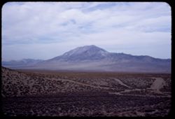
- Pyramid Lake (Nev.), Hills, Mountains, and Shrubs
- Series:
- 12-58
- Creator:
- Cushman, Charles W., 1896-1972
- Date Created:
- 1958-06-18
- Genre:
- Landscape photographs
- Frame Number:
- 33
- County:
- Washoe
- Abstract:
- Mtn. North of Wadsworth
- Call Number:
- P10044
- City:
- Wadsworth
- Country:
- United States
- State/Province:
- Nevada
- Alternate Identifier:
- 1258.33
- Persistent URL:
- http://purl.dlib.indiana.edu/iudl/archives/cushman/P10044
- Holding Location:
- Bloomington - University Archives
Wells Library E460
1320 E 10th St.
Bloomington, IN 47405
Contact at archives@indiana.edu, 812-855-1127
-
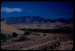
- Description:
- 100 f 6.7 TL
- Subject:
- Plains, Mountains, Shrubs, Clouds, and Hills
- Series:
- 12-58
- Creator:
- Cushman, Charles W., 1896-1972
- Date Created:
- 1958-06-17
- Genre:
- Landscape photographs
- Frame Number:
- 28
- County:
- Elko
- Abstract:
- Fine saw-tooth ridge to the SE (near Contact)
- Call Number:
- P10040
- City:
- Contact
- Country:
- United States
- State/Province:
- Nevada
- Alternate Identifier:
- 1258.28
- Persistent URL:
- http://purl.dlib.indiana.edu/iudl/archives/cushman/P10040
- Holding Location:
- Bloomington - University Archives
Wells Library E460
1320 E 10th St.
Bloomington, IN 47405
Contact at archives@indiana.edu, 812-855-1127
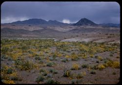
-
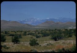
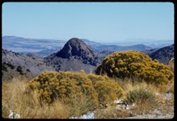
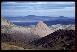
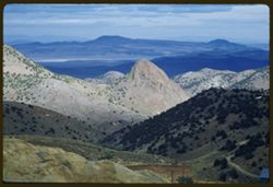
- Description:
- 100 f 9 t
- Subject:
- Wildflowers, Grasses, Charleston Peak (Nev.), Spring Mountains (Nev.), Mountains, Rock formations, Hills, and Shrubs
- Series:
- 3-58
- Creator:
- Cushman, Charles W., 1896-1972
- Date Created:
- 1958-04-25
- Genre:
- Landscape photographs
- Frame Number:
- 27
- Street Address:
- United States Highway 95
- County:
- Clark
- Abstract:
- Distant view of Spring Mtns (Charleston Peak) from Hwy near Sloan
- Call Number:
- P09743
- City:
- Sloan
- Country:
- United States
- State/Province:
- Nevada
- Alternate Identifier:
- 358.27
- Persistent URL:
- http://purl.dlib.indiana.edu/iudl/archives/cushman/P09743
- Holding Location:
- Bloomington - University Archives
Wells Library E460
1320 E 10th St.
Bloomington, IN 47405
Contact at archives@indiana.edu, 812-855-1127
-
- Description:
- 50 f 9
- Subject:
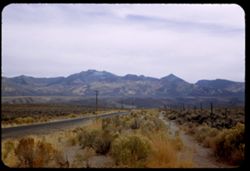
- Silver Zone Pass (Nev.), Grasses, Dirt roads, Mountains, Clouds, Silver Zone (Nev.), Hills, and Pilot Peak (Elko County, Nev.)
- Series:
- 9-53
- Creator:
- Cushman, Charles W., 1896-1972
- Date Created:
- 1953-10-10
- Genre:
- Landscape photographs
- Frame Number:
- 8
- Street Address:
- United States Highway 40
- County:
- Elko
- Abstract:
- Pilot Pk. 10704 fromUS 40 below Silver Zone Pass. Overcast.
- Call Number:
- P06809
- Country:
- United States
- State/Province:
- Nevada
- Alternate Identifier:
- 953.8
- Persistent URL:
- http://purl.dlib.indiana.edu/iudl/archives/cushman/P06809
- Holding Location:
- Bloomington - University Archives
Wells Library E460
1320 E 10th St.
Bloomington, IN 47405
Contact at archives@indiana.edu, 812-855-1127
-
- Description:
- 25 f 6.3 Pola
- Subject:
- Grasses, Roads, Trails & paths, Ruby Mountains (Nev.), Mountains, Shrubs, Hills, Utility poles, Wood poles, and Plains
- Series:
- 9-53
- Creator:
- Cushman, Charles W., 1896-1972
- Date Created:
- 1953-10-10
- Genre:
- Landscape photographs
- Frame Number:
- 7
- Street Address:
- United States Highway 40
- County:
- Elko
- Abstract:
- Ruby range from nr. Deeth.
- Call Number:
- P06808
- City:
- Deeth
- Country:
- United States
- State/Province:
- Nevada
- Alternate Identifier:
- 953.7
- Persistent URL:
- http://purl.dlib.indiana.edu/iudl/archives/cushman/P06808
- Holding Location:
- Bloomington - University Archives
Wells Library E460
1320 E 10th St.
Bloomington, IN 47405
Contact at archives@indiana.edu, 812-855-1127
-
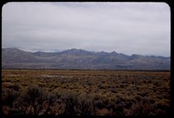
- Description:
- 50 f 5.6 Pola
- Subject:
- Grasses, Plains, Mountains, Shrubs, Clouds, Hills, Utility poles, and Ruby Mountains (Nev.)
- Series:
- 9-53
- Creator:
- Cushman, Charles W., 1896-1972
- Date Created:
- 1953-10-10
- Genre:
- Landscape photographs
- Frame Number:
- 6
- Street Address:
- United States Highway 40
- County:
- Elko
- Abstract:
- Ruby Mtns. from US 40 between Elko + Wells. Overcast.
- Call Number:
- P06807
- City:
- Wells and Elko
- Country:
- United States
- State/Province:
- Nevada
- Alternate Identifier:
- 953.6
- Persistent URL:
- http://purl.dlib.indiana.edu/iudl/archives/cushman/P06807
- Holding Location:
- Bloomington - University Archives
Wells Library E460
1320 E 10th St.
Bloomington, IN 47405
Contact at archives@indiana.edu, 812-855-1127
-
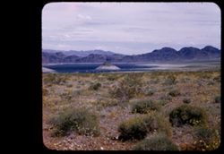
- Description:
- 50 f 8 Pola
- Subject:
- Grasses, Birds, Carson Sink (Nev.), Waterfronts, Hills, Reflections, Bodies of water, and Dirt
- Series:
- 8-53
- Creator:
- Cushman, Charles W., 1896-1972
- Date Created:
- 1953-10-09
- Genre:
- Landscape photographs
- Frame Number:
- 39
- County:
- Churchill
- Abstract:
- Carson Sink.
- Call Number:
- P06801
- Country:
- United States
- State/Province:
- Nevada
- Physical Description:
- masked.
- Alternate Identifier:
- 853.39
- Persistent URL:
- http://purl.dlib.indiana.edu/iudl/archives/cushman/P06801
- Holding Location:
- Bloomington - University Archives
Wells Library E460
1320 E 10th St.
Bloomington, IN 47405
Contact at archives@indiana.edu, 812-855-1127
-
- Description:
- 50 f 8 Pola
- Subject:
- Hills, Roads, Dirt, Mountains, Shrubs, Trees, Grasses, and Clouds
- Series:
- 8-53
- Creator:
- Cushman, Charles W., 1896-1972
- Date Created:
- 1953-10-09
- Genre:
- Landscape photographs
- Frame Number:
- 38
- Street Address:
- United States Highway 50
- County:
- Lyon
- Abstract:
- View east from US 50 near Dayton.
- Call Number:
- P06800
- City:
- Dayton
- Country:
- United States
- State/Province:
- Nevada
- Alternate Identifier:
- 853.38
- Persistent URL:
- http://purl.dlib.indiana.edu/iudl/archives/cushman/P06800
- Holding Location:
- Bloomington - University Archives
Wells Library E460
1320 E 10th St.
Bloomington, IN 47405
Contact at archives@indiana.edu, 812-855-1127
-
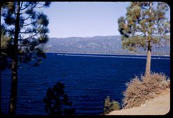
- Description:
- 50 f 6.3
- Subject:
- Lakes & ponds, Tree limbs, Hills, Forests, Mountains, Shrubs, Piers & wharves, and Tahoe, Lake (Calif. and Nev.)
- Series:
- 28-52
- Creator:
- Cushman, Charles W., 1896-1972
- Date Created:
- 1952-11-08
- Genre:
- Landscape photographs
- Frame Number:
- 21
- Abstract:
- Lake Tahoe.
- Call Number:
- P06505
- Country:
- United States
- State/Province:
- Nevada and California
- Alternate Identifier:
- 2852.21
- Persistent URL:
- http://purl.dlib.indiana.edu/iudl/archives/cushman/P06505
- Holding Location:
- Bloomington - University Archives
Wells Library E460
1320 E 10th St.
Bloomington, IN 47405
Contact at archives@indiana.edu, 812-855-1127
-
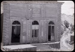
- Description:
- 25 f 10
- Subject:
- Balconies, Facades, Miners' unions, Signs (Notices), Streets, Mountains, Sidewalks, Miner's Union Hall (Virginia City, Nev.), Hills, Building deterio...
- Series:
- 28-52
- Creator:
- Cushman, Charles W., 1896-1972
- Date Created:
- 1952-11-08
- Genre:
- Architectural photographs
- Frame Number:
- 18
- County:
- Storey
- Abstract:
- Miners Union Hall.
- Call Number:
- P06502
- City:
- Virginia City
- Country:
- United States
- State/Province:
- Nevada
- Alternate Identifier:
- 2852.18
- Persistent URL:
- http://purl.dlib.indiana.edu/iudl/archives/cushman/P06502
- Holding Location:
- Bloomington - University Archives
Wells Library E460
1320 E 10th St.
Bloomington, IN 47405
Contact at archives@indiana.edu, 812-855-1127
-

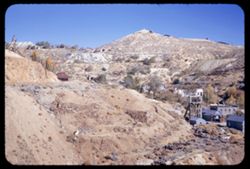
- Description:
- 25 f 6.3 Pola
- Subject:
- Deserts, Mining, Mountains, Shrubs, Hills, and Mining equipment
- Series:
- 28-52
- Creator:
- Cushman, Charles W., 1896-1972
- Date Created:
- 1952-11-08
- Genre:
- Landscape photographs
- Frame Number:
- 15
- County:
- Storey
- Abstract:
- Panorama east from Va. City.
- Call Number:
- P06499
- City:
- Virginia City
- Country:
- United States
- State/Province:
- Nevada
- Alternate Identifier:
- 2852.15
- Persistent URL:
- http://purl.dlib.indiana.edu/iudl/archives/cushman/P06499
- Holding Location:
- Bloomington - University Archives
Wells Library E460
1320 E 10th St.
Bloomington, IN 47405
Contact at archives@indiana.edu, 812-855-1127
-
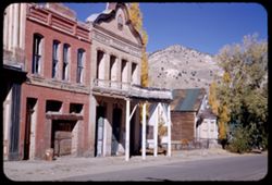
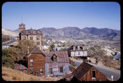
- Description:
- 25 f 9
- Subject:
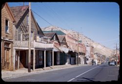
- Balconies, Electric lines, Automobiles, Streets, Cities & towns, Buildings, Mercantile facilities, Hills, Utility poles, Building deterioration, Mountain...
- Series:
- 28-52
- Creator:
- Cushman, Charles W., 1896-1972
- Date Created:
- 1952-11-08
- Genre:
- Views
- Frame Number:
- 16
- Street Address:
- Main Street
- County:
- Storey
- Abstract:
- Down Main St.
- Call Number:
- P06500
- City:
- Virginia City
- Country:
- United States
- State/Province:
- Nevada
- Alternate Identifier:
- 2852.16
- Persistent URL:
- http://purl.dlib.indiana.edu/iudl/archives/cushman/P06500
- Holding Location:
- Bloomington - University Archives
Wells Library E460
1320 E 10th St.
Bloomington, IN 47405
Contact at archives@indiana.edu, 812-855-1127
-
- Description:
- 25 f 11
- Subject:
- Cities & towns, Streets, Hills, Mountains, Utility poles, Building deterioration, Trees, Buildings, Towers, Barns, Dwellings, and Shrubs
- Series:
- 28-52
- Creator:
- Cushman, Charles W., 1896-1972
- Date Created:
- 1952-11-08
- Genre:
- Views
- Frame Number:
- 14
- County:
- Storey
- Abstract:
- Virginia City.
- Call Number:
- P06498
- City:
- Virginia City
- Country:
- United States
- State/Province:
- Nevada
- Alternate Identifier:
- 2852.14
- Persistent URL:
- http://purl.dlib.indiana.edu/iudl/archives/cushman/P06498
- Holding Location:
- Bloomington - University Archives
Wells Library E460
1320 E 10th St.
Bloomington, IN 47405
Contact at archives@indiana.edu, 812-855-1127
-
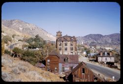
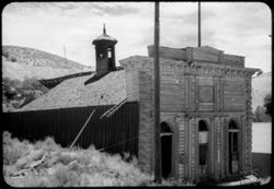
- Description:
- 25 f 11
- Subject:
- Gold mining equipment, Gold mining, Mine buildings, Trees, Mining, Retaining walls, Mountains, Buildings, Headframes (Mining), Hills, Mining equipment, and H...
- Series:
- 28-52
- Creator:
- Cushman, Charles W., 1896-1972
- Date Created:
- 1952-11-08
- Genre:
- Views
- Frame Number:
- 12
- County:
- Storey
- Abstract:
- Mtn scene - across old town of Gold Hill.
- Call Number:
- P06496
- City:
- Gold Hill and Virginia City
- Country:
- United States
- State/Province:
- Nevada
- Alternate Identifier:
- 2852.12
- Persistent URL:
- http://purl.dlib.indiana.edu/iudl/archives/cushman/P06496
- Holding Location:
- Bloomington - University Archives
Wells Library E460
1320 E 10th St.
Bloomington, IN 47405
Contact at archives@indiana.edu, 812-855-1127
-
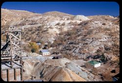
- Description:
- 25 f 6.3 Pola
- Subject:
- Towers, Gold mining equipment, Gold mining, Mine buildings, Trees, Mining, Mountains, Shrubs, Headframes (Mining), Hills, Mining equipment, and Houses
- Series:
- 28-52
- Creator:
- Cushman, Charles W., 1896-1972
- Date Created:
- 1952-11-08
- Genre:
- Views
- Frame Number:
- 11
- County:
- Storey
- Abstract:
- Mtn scene - across old town of Gold Hill.
- Call Number:
- P06495
- City:
- Gold Hill
- Country:
- United States
- State/Province:
- Nevada
- Alternate Identifier:
- 2852.11
- Persistent URL:
- http://purl.dlib.indiana.edu/iudl/archives/cushman/P06495
- Holding Location:
- Bloomington - University Archives
Wells Library E460
1320 E 10th St.
Bloomington, IN 47405
Contact at archives@indiana.edu, 812-855-1127
-
- Description:
- 25 f 11
- Subject:
- Wildflowers, Gold mining equipment, Gold mining, Mine buildings, Trees, Mining, Mountains, Shrubs, Headframes (Mining), Hills, Mining equipment, and Towers
- Series:
- 28-52
- Creator:
- Cushman, Charles W., 1896-1972
- Date Created:
- 1952-11-08
- Genre:
- Landscape photographs
- Frame Number:
- 10
- County:
- Storey
- Abstract:
- Trees + Mtns near Gold Hill.
- Call Number:
- P06494
- City:
- Gold Hill
- Country:
- United States
- State/Province:
- Nevada
- Alternate Identifier:
- 2852.10
- Persistent URL:
- http://purl.dlib.indiana.edu/iudl/archives/cushman/P06494
- Holding Location:
- Bloomington - University Archives
Wells Library E460
1320 E 10th St.
Bloomington, IN 47405
Contact at archives@indiana.edu, 812-855-1127
-
- Description:
- 25 f 11
- Subject:
- Towers, Barns, Mine buildings, Trees, Streets, Mountains, Buildings, Dwellings, Hills, Utility poles, Building deterioration, and Cities & towns
- Series:
- 28-52
- Creator:
- Cushman, Charles W., 1896-1972
- Date Created:
- 1952-11-08
- Genre:
- Views
- Frame Number:
- 13
- County:
- Storey
- Abstract:
- Virginia City.
- Call Number:
- P06497
- City:
- Virginia City
- Country:
- United States
- State/Province:
- Nevada
- Alternate Identifier:
- 2852.13
- Persistent URL:
- http://purl.dlib.indiana.edu/iudl/archives/cushman/P06497
- Holding Location:
- Bloomington - University Archives
Wells Library E460
1320 E 10th St.
Bloomington, IN 47405
Contact at archives@indiana.edu, 812-855-1127
-
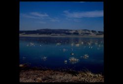
- Description:
- 50 f 9
- Subject:
- Wildflowers, Bays (Bodies of water), Hoover Dam (Ariz. and Nev.), Mountains, Shrubs, Lakes & ponds, Islands, Hills, and Mead, Lake (Ariz. and Nev.)
- Series:
- 16-52
- Creator:
- Cushman, Charles W., 1896-1972
- Date Created:
- 1952-04-10
- Genre:
- Landscape photographs
- Frame Number:
- 1
- County:
- Clark
- Abstract:
- Mtn top in bay of L. Mead.
- Call Number:
- P06061
- Country:
- United States
- State/Province:
- Nevada
- Physical Description:
- masked.
- Alternate Identifier:
- 1652.1
- Persistent URL:
- http://purl.dlib.indiana.edu/iudl/archives/cushman/P06061
- Holding Location:
- Bloomington - University Archives
Wells Library E460
1320 E 10th St.
Bloomington, IN 47405
Contact at archives@indiana.edu, 812-855-1127
-
- Description:
- 25 f 8
- Subject:
- Wildflowers, Mead, Lake (Ariz. and Nev.), Mountains, Rock formations, Clouds, Hills, Deserts, Pyramidal mountain, and Shrubs
- Series:
- 15-52
- Creator:
- Cushman, Charles W., 1896-1972
- Date Created:
- 1952-04-10
- Genre:
- Landscape photographs
- Frame Number:
- 41
- County:
- Clark
- Abstract:
- Yellow desert flowers + pyramidal mtn. near Lake Mead.
- Call Number:
- P06060
- Country:
- United States
- State/Province:
- Nevada
- Alternate Identifier:
- 1542.41
- Persistent URL:
- http://purl.dlib.indiana.edu/iudl/archives/cushman/P06060
- Holding Location:
- Bloomington - University Archives
Wells Library E460
1320 E 10th St.
Bloomington, IN 47405
Contact at archives@indiana.edu, 812-855-1127
-
- Subject:
- Trees, Abandoned buildings, Shrubs, Railroad tracks, Hills, and Building deterioration
- Series:
- 24-40
- Creator:
- Cushman, Charles W., 1896-1972
- Date Created:
- 1940-07-08
- Frame Number:
- 29
- County:
- Storey
- Abstract:
- 40-K-29=old bldgs. In Gold Hill, Nev.
- Call Number:
- P01954
- City:
- Gold Hill
- Country:
- United States
- State/Province:
- Nevada
- Physical Description:
- black & white .
- Alternate Identifier:
- 2440.29
- Persistent URL:
- http://purl.dlib.indiana.edu/iudl/archives/cushman/P01954
- Holding Location:
- Bloomington - University Archives
Wells Library E460
1320 E 10th St.
Bloomington, IN 47405
Contact at archives@indiana.edu, 812-855-1127
-
- Subject:
- Abandoned buildings, Hills, Weeds, Ladders, Shrubs, Building deterioration, Trees, Towers, and Clouds
- Series:
- 24-40
- Creator:
- Cushman, Charles W., 1896-1972
- Date Created:
- 1940-07-08
- Genre:
- Architectural photographs
- Frame Number:
- 30
- County:
- Storey
- Abstract:
- 40-K-30=old bldgs. In Gold Hill, Nev.
- Call Number:
- P01953
- City:
- Gold Hill
- Country:
- United States
- State/Province:
- Nevada
- Physical Description:
- black & white .
- Alternate Identifier:
- 2440.30
- Persistent URL:
- http://purl.dlib.indiana.edu/iudl/archives/cushman/P01953
- Holding Location:
- Bloomington - University Archives
Wells Library E460
1320 E 10th St.
Bloomington, IN 47405
Contact at archives@indiana.edu, 812-855-1127