
Search Constraints
You searched for:
Campus
IUB
Remove constraint Campus: IUB
Subject
Mountains
Remove constraint Subject: Mountains
Subject
Shrubs
Remove constraint Subject: Shrubs
Subject
Grasses
Remove constraint Subject: Grasses
« Previous |
1 - 100 of 145
|
Next »
Search Results
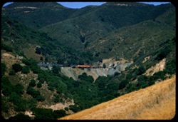
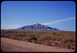
-
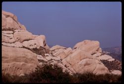
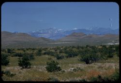
- Description:
- 100 f 9 TL
- Subject:
- Passes (Landforms), Cajon Pass (Calif.), Shrubs, Rock formations, Mountains, and Grasses
- Series:
- 3-69
- Creator:
- Cushman, Charles W., 1896-1972
- Date Created:
- 1969-03-20
- Genre:
- Landscape photographs
- Frame Number:
- 15
- County:
- San Bernardino
- Abstract:
- In Cajon Pass
- Call Number:
- P15767
- Country:
- United States
- State/Province:
- California
- Alternate Identifier:
- 369.15
- Persistent URL:
- http://purl.dlib.indiana.edu/iudl/archives/cushman/P15767
-
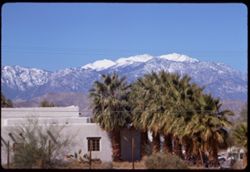
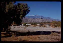
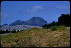
- Description:
- 100 f 9 TL
- Subject:
- San Jacinto Peak (Calif.), Mountains, Shrubs, Electric lines, Buildings, Palms, Grasses, and Snow
- Series:
- 2-69
- Creator:
- Cushman, Charles W., 1896-1972
- Date Created:
- 1969-03-16
- Genre:
- Landscape photographs and Views
- Frame Number:
- 25
- County:
- Riverside
- Abstract:
- China berry Mt. San Jacinto near Palm springs
- Call Number:
- P15742
- City:
- Palm Springs
- Country:
- United States
- State/Province:
- California
- Alternate Identifier:
- 269.25
- Persistent URL:
- http://purl.dlib.indiana.edu/iudl/archives/cushman/P15742
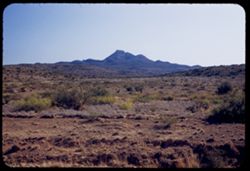
-
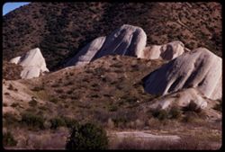
- Description:
- 100 f 9 TL
- Subject:
- Passes (Landforms), Hills, Cajon Pass (Calif.), Shrubs, Trees, Rock formations, Mountains, and Grasses
- Series:
- 2-69
- Creator:
- Cushman, Charles W., 1896-1972
- Date Created:
- 1969-03-14
- Genre:
- Landscape photographs
- Frame Number:
- 17
- County:
- San Bernardino
- Abstract:
- Cajon Pass
- Call Number:
- P15734
- Country:
- United States
- State/Province:
- California
- Alternate Identifier:
- 269.17
- Persistent URL:
- http://purl.dlib.indiana.edu/iudl/archives/cushman/P15734
-
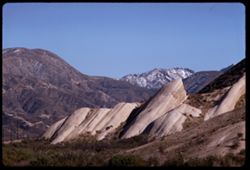
- Description:
- 100 f 9 TL
- Subject:
- Passes (Landforms), Mountains, Shrubs, Snow, Rock formations, Cajon Pass (Calif.), and Grasses
- Series:
- 2-69
- Creator:
- Cushman, Charles W., 1896-1972
- Date Created:
- 1969-03-14
- Genre:
- Landscape photographs
- Frame Number:
- 16
- County:
- San Bernardino
- Abstract:
- Cajon Pass
- Call Number:
- P15733
- Country:
- United States
- State/Province:
- California
- Alternate Identifier:
- 269.16
- Persistent URL:
- http://purl.dlib.indiana.edu/iudl/archives/cushman/P15733
-
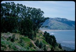
- Description:
- 100 f 8
- Subject:
- Bays (Bodies of water), Grasses, Cliffs, Trees, Coastlines, Bolinas Bay (Calif.), Mountains, Beaches, Shrubs, and Hills
- Series:
- 1-68
- Creator:
- Cushman, Charles W., 1896-1972
- Date Created:
- 1968-03-20
- Genre:
- Landscape photographs and Seascapes
- Frame Number:
- 29
- County:
- Marin
- Abstract:
- Across Bolinas Bay
- Call Number:
- P15623
- City:
- Bolinas
- Country:
- United States
- State/Province:
- California
- Alternate Identifier:
- 168.29
- Persistent URL:
- http://purl.dlib.indiana.edu/iudl/archives/cushman/P15623
-
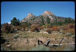
- Description:
- 100 f 13 sl
- Subject:
- Grasses, Trees, Mountains, Fences, Shrubs, and Rock formations
- Series:
- 34-65
- Creator:
- Cushman, Charles W., 1896-1972
- Date Created:
- 1965-10-03
- Genre:
- Landscape photographs
- Frame Number:
- 14
- County:
- La Plata
- Abstract:
- 2 truncated pyramids w. of Durango
- Call Number:
- P15006
- City:
- Durango
- Country:
- United States
- State/Province:
- Colorado
- Alternate Identifier:
- 3465.14
- Persistent URL:
- http://purl.dlib.indiana.edu/iudl/archives/cushman/P15006
-

- Description:
- 100 f 13
- Subject:
- Rocks, Grasses, Roads, Mountains, Shrubs, Bridges, Animas River (Colo. and N.M.), and Rivers
- Series:
- 34-65
- Creator:
- Cushman, Charles W., 1896-1972
- Date Created:
- 1965-10-03
- Genre:
- Landscape photographs
- Frame Number:
- 12
- County:
- La Plata
- Abstract:
- Animas river below Durango
- Call Number:
- P15004
- City:
- Durango
- Country:
- United States
- State/Province:
- Colorado
- Alternate Identifier:
- 3465.12
- Persistent URL:
- http://purl.dlib.indiana.edu/iudl/archives/cushman/P15004
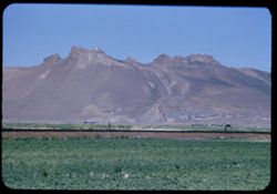
-
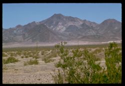
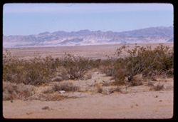
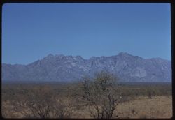
- Description:
- 100 f 11 TL
- Subject:
- Deserts, Mojave Desert (Calif.), Grasses, Cady Mountains (Calif.), Mountains, and Shrubs
- Series:
- 5-62
- Creator:
- Cushman, Charles W., 1896-1972
- Date Created:
- 1962-10-08
- Genre:
- Landscape photographs
- Frame Number:
- 26
- Street Address:
- United States Highway 66
- County:
- San Bernardino
- Abstract:
- Cady Mtns
- Call Number:
- P12793
- City:
- Barstow
- Country:
- United States
- State/Province:
- California
- Alternate Identifier:
- 562.26
- Persistent URL:
- http://purl.dlib.indiana.edu/iudl/archives/cushman/P12793
-
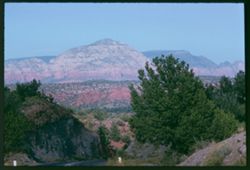
- Description:
- 100 f 9
- Subject:
- Hills, Roads, Cliffs, Mountains, Shrubs, Trees, and Grasses
- Series:
- 5-62
- Creator:
- Cushman, Charles W., 1896-1972
- Date Created:
- 1962-10-05
- Genre:
- Landscape photographs
- Frame Number:
- 17
- County:
- Coconino
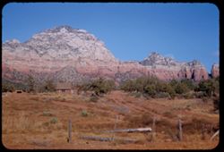
- Abstract:
- East from 6 or 7 mi. west of Sedona
- Call Number:
- P12784
- City:
- Sedona
- Country:
- United States
- State/Province:
- Arizona
- Alternate Identifier:
- 562.17
- Persistent URL:
- http://purl.dlib.indiana.edu/iudl/archives/cushman/P12784
-
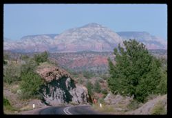
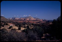
- Description:
- 100 f 11
- Subject:
- Hills, Roads, Cliffs, Mountains, Shrubs, Trees, and Grasses
- Series:
- 5-62
- Creator:
- Cushman, Charles W., 1896-1972
- Date Created:
- 1962-10-05
- Genre:
- Landscape photographs
- Frame Number:
- 16
- County:
- Coconino
- Abstract:
- East from 6 or 7 mi. west of Sedona
- Call Number:
- P12783
- City:
- Sedona
- Country:
- United States
- State/Province:
- Arizona
- Alternate Identifier:
- 562.16
- Persistent URL:
- http://purl.dlib.indiana.edu/iudl/archives/cushman/P12783
-
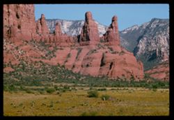
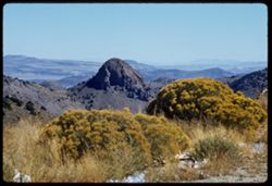
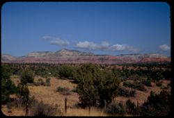
- Description:
- 100 f 11 TL
- Subject:
- Erosion, Cliffs, Buttes, Mountains, Rock formations, Grasses, and Shrubs
- Series:
- 5-62
- Creator:
- Cushman, Charles W., 1896-1972
- Date Created:
- 1962-10-05
- Genre:
- Landscape photographs
- Frame Number:
- 10
- County:
- Coconino
- Abstract:
- Little peaks so. of Sedona from west
- Call Number:
- P12777
- City:
- Sedona
- Country:
- United States
- State/Province:
- Arizona
- Alternate Identifier:
- 562.10
- Persistent URL:
- http://purl.dlib.indiana.edu/iudl/archives/cushman/P12777
-
- Description:
- 100 f 8 TL
- Subject:
- Rocks, Grasses, Mountains, Shrubs, and Hills
- Series:
- 3-62
- Creator:
- Cushman, Charles W., 1896-1972
- Date Created:
- 1962-09-29
- Genre:
- Landscape photographs
- Frame Number:
- 30
- County:
- Storey
- Abstract:
- View east from [dome]
- Call Number:
- P12727
- City:
- Virginia City
- Country:
- United States
- State/Province:
- Nevada
- Alternate Identifier:
- 362.30
- Persistent URL:
- http://purl.dlib.indiana.edu/iudl/archives/cushman/P12727
-
- Description:
- 100 f 8 TL
- Subject:
- Deserts, Grasses, San Bernardino Desert (Calif.), Mountains, and Shrubs
- Series:
- 24-61
- Creator:
- Cushman, Charles W., 1896-1972
- Date Created:
- 1961-12-29
- Genre:
- Landscape photographs
- Frame Number:
- 27
- County:
- San Bernardino
- Abstract:
- Panorama north from 12 mi. w. of 29 Palms and Panorama north of 29 Palm S Hwy 7 miles west of 29 Palms San Bernardino Desert
- Call Number:
- P12593
- City:
- Twentynine Palms
- Country:
- United States
- State/Province:
- California
- Alternate Identifier:
- 2461.27
- Persistent URL:
- http://purl.dlib.indiana.edu/iudl/archives/cushman/P12593
-
- Description:
- 100 f 6..3 TL
- Subject:
- Grasses, Houses, Trees, San Jacinto Peak (Calif.), Shadows, Mountains, and Shrubs
- Series:
- 23-61
- Creator:
- Cushman, Charles W., 1896-1972
- Date Created:
- 1961-12-25
- Genre:
- Landscape photographs
- Frame Number:
- 37
- County:
- Riverside
- Abstract:
- Mr. San Jacinto from Palm Desert and Mt. San Jacinto from Palm Desert
- Call Number:
- P12566
- City:
- Palm Desert
- Country:
- United States
- State/Province:
- California
- Alternate Identifier:
- 2361.37
- Persistent URL:
- http://purl.dlib.indiana.edu/iudl/archives/cushman/P12566
-
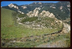
- Description:
- 50 f 8
- Subject:
- Grasses, Barbed wire, Mountains, Fences, Shrubs, and Hills
- Series:
- 27-60
- Creator:
- Cushman, Charles W., 1896-1972
- Date Created:
- 1960-12-29
- Genre:
- Landscape photographs
- Frame Number:
- 7
- Street Address:
- United States Highway 101
- County:
- Santa Barbara
- Abstract:
- Hills north of Gaviota
- Call Number:
- P11749
- City:
- Gaviota
- Country:
- United States
- State/Province:
- California
- Alternate Identifier:
- 2760.7
- Persistent URL:
- http://purl.dlib.indiana.edu/iudl/archives/cushman/P11749
-
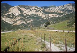
- Description:
- 50 f 8
- Subject:
- Grasses, Roads, Grazing, Barbed wire, Livestock, Mountains, Fences, Shrubs, Hills, and Utility poles
- Series:
- 27-60
- Creator:
- Cushman, Charles W., 1896-1972
- Date Created:
- 1960-12-29
- Genre:
- Landscape photographs
- Frame Number:
- 6
- County:
- Santa Barbara
- Abstract:
- Hills north of Gaviota
- Call Number:
- P11748
- City:
- Gaviota
- Country:
- United States
- State/Province:
- California
- Alternate Identifier:
- 2760.6
- Persistent URL:
- http://purl.dlib.indiana.edu/iudl/archives/cushman/P11748
-
- Description:
- 50 f 8 sl
- Subject:
- Rocks, Columbia River, Cliffs, Trees, Plains, Mountains, Shrubs, Hills, and Grasses
- Series:
- 24-60
- Creator:
- Cushman, Charles W., 1896-1972
- Date Created:
- 1960-09-19
- Genre:
- Landscape photographs
- Frame Number:
- 16
- County:
- Wasco
- Abstract:
- Washington side of Columbia 10m: from The Dalles
- Call Number:
- P11670
- City:
- Dalles
- Country:
- United States
- State/Province:
- Washington
- Alternate Identifier:
- 2460.16
- Persistent URL:
- http://purl.dlib.indiana.edu/iudl/archives/cushman/P11670
-
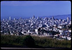
- Description:
- 100 f 8 TL
- Subject:
- Domes, Streets, Hills, Skyscrapers, Roads, Mountains, Shrubs, Buildings, Grasses, Houses, and Dwellings
- Series:
- 12-59
- Creator:
- Cushman, Charles W., 1896-1972
- Date Created:
- 1959-05-10
- Genre:
- Cityscape photographs
- Frame Number:
- 36
- Street Address:
- Clipper Street
- County:
- San Francisco
- Abstract:
- From top of Clipper St.
- Call Number:
- P10798
- City:
- San Francisco
- Country:
- United States
- State/Province:
- California
- Alternate Identifier:
- 1259.36
- Persistent URL:
- http://purl.dlib.indiana.edu/iudl/archives/cushman/P10798
-
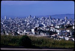
- Description:
- 100 f 8 TL
- Subject:
- Grasses, Houses, Skyscrapers, Streets, Mountains, Buildings, Shrubs, Dwellings, Domes, Roads, and Hills
- Series:
- 12-59
- Creator:
- Cushman, Charles W., 1896-1972
- Date Created:
- 1959-05-10
- Genre:
- Cityscape photographs
- Frame Number:
- 35
- Street Address:
- Clipper Street
- County:
- San Francisco
- Abstract:
- From top of Clipper St.
- Call Number:
- P10797
- City:
- San Francisco
- Country:
- United States
- State/Province:
- California
- Alternate Identifier:
- 1259.35
- Persistent URL:
- http://purl.dlib.indiana.edu/iudl/archives/cushman/P10797
-
- Description:
- 100 f 9 tl
- Subject:
- Baboquivari Peak (Ariz.), Mountains, Shrubs, and Grasses
- Series:
- 6-59
- Creator:
- Cushman, Charles W., 1896-1972
- Date Created:
- 1959-01-28
- Genre:
- Landscape photographs
- Frame Number:
- 17
- County:
- Pima
- Abstract:
- Broadside view of Babo. range further north of PK.
- Call Number:
- P10555
- Country:
- United States
- State/Province:
- Arizona
- Alternate Identifier:
- 659.17
- Persistent URL:
- http://purl.dlib.indiana.edu/iudl/archives/cushman/P10555
-
- Description:
- 100 f 6.3 tl
- Subject:
- Electric lines, Davis Mountains (Tex.), Mountains, Shrubs, Clouds, and Grasses
- Series:
- 5-59
- Creator:
- Cushman, Charles W., 1896-1972
- Date Created:
- 1959-01-19
- Genre:
- Landscape photographs
- Frame Number:
- 1
- County:
- Jeff Davis
- Abstract:
- Low broad mtn.
- Call Number:
- P10502
- City:
- Fort Davis
- Country:
- United States
- State/Province:
- Texas
- Alternate Identifier:
- 559.1
- Persistent URL:
- http://purl.dlib.indiana.edu/iudl/archives/cushman/P10502
-
- Description:
- 100 f 8 tl
- Subject:
- Grasses, Plains, Mountains, Rock formations, Clouds, Pilot Peak (Elko County, Nev.), and Shrubs
- Series:
- 15-58
- Creator:
- Cushman, Charles W., 1896-1972
- Date Created:
- 1958-08-23
- Genre:
- Landscape photographs
- Frame Number:
- 19
- Street Address:
- United States Highway 40
- County:
- Elko
- Abstract:
- Interesting granite double peak no. of US 40 between Wells & Wendover (Pilot Peak)
- Call Number:
- P10125
- City:
- Eastline and Wells
- Country:
- United States
- State/Province:
- Nevada
- Alternate Identifier:
- 1558.19
- Persistent URL:
- http://purl.dlib.indiana.edu/iudl/archives/cushman/P10125
-
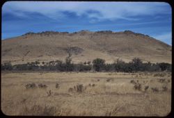
- Description:
- 100 f 5.6 TL HF
- Subject:
- Boise Ridge (Idaho), Grasses, Mountains, Fences, Shrubs, Clouds, and Hills
- Series:
- 11-58
- Creator:
- Cushman, Charles W., 1896-1972
- Date Created:
- 1958-06-15
- Genre:
- Landscape photographs
- Frame Number:
- 26
- County:
- Boise
- Abstract:
- Slope of Boise ridge - hazy
- Call Number:
- P10001
- City:
- Horseshoe Bend
- Country:
- United States
- State/Province:
- Idaho
- Alternate Identifier:
- 1158.26
- Persistent URL:
- http://purl.dlib.indiana.edu/iudl/archives/cushman/P10001
-
- Description:
- 100 f 6.3 SL
- Subject:
- Grasses, Volcanic rock, Mountains, Shrubs, and Clouds
- Series:
- 11-58
- Creator:
- Cushman, Charles W., 1896-1972
- Date Created:
- 1958-06-14
- Genre:
- Landscape photographs
- Frame Number:
- 5
- Street Address:
- United States Highway 20
- County:
- Malheur
- Abstract:
- Great brown lava
- Call Number:
- P09980
- Country:
- United States
- State/Province:
- Oregon
- Alternate Identifier:
- 1158.5
- Persistent URL:
- http://purl.dlib.indiana.edu/iudl/archives/cushman/P09980
-
- Description:
- 100 f 8 tl
- Subject:
- Grasses, Dirt roads, Trees, Mountains, Shrubs, Mormon Mountains (Nev.), and Rock formations
- Series:
- 3-58
- Creator:
- Cushman, Charles W., 1896-1972
- Date Created:
- 1958-04-25
- Genre:
- Landscape photographs
- Frame Number:
- 31
- County:
- Clark
- Abstract:
- Mormon Range from Glendale
- Call Number:
- P09747
- City:
- Glendale
- Country:
- United States
- State/Province:
- Nevada
- Alternate Identifier:
- 358.31
- Persistent URL:
- http://purl.dlib.indiana.edu/iudl/archives/cushman/P09747
-
- Description:
- 100 f 9 t
- Subject:
- Wildflowers, Grasses, Charleston Peak (Nev.), Spring Mountains (Nev.), Mountains, Rock formations, Hills, and Shrubs
- Series:
- 3-58
- Creator:
- Cushman, Charles W., 1896-1972
- Date Created:
- 1958-04-25
- Genre:
- Landscape photographs
- Frame Number:
- 27
- Street Address:
- United States Highway 95
- County:
- Clark
- Abstract:
- Distant view of Spring Mtns (Charleston Peak) from Hwy near Sloan
- Call Number:
- P09743
- City:
- Sloan
- Country:
- United States
- State/Province:
- Nevada
- Alternate Identifier:
- 358.27
- Persistent URL:
- http://purl.dlib.indiana.edu/iudl/archives/cushman/P09743
-
- Description:
- 100 f 8 tl
- Subject:
- Grasses, Mountains, Shrubs, and Hollister Peak (Calif.)
- Series:
- 14-57
- Creator:
- Cushman, Charles W., 1896-1972
- Date Created:
- 1957-09-19
- Genre:
- Landscape photographs
- Frame Number:
- 14
- Street Address:
- Morro Bay Road, California State Highway 1, and Pacific Coast Highway
- County:
- San Luis Obispo
- Abstract:
- Rocky comb (Hollister Pk) along Cal 1 between San Luis & Morro Bay
- Call Number:
- P09513
- City:
- San Luis Obispo and Morro Bay
- Country:
- United States
- State/Province:
- California
- Alternate Identifier:
- 1457.14
- Persistent URL:
- http://purl.dlib.indiana.edu/iudl/archives/cushman/P09513
-
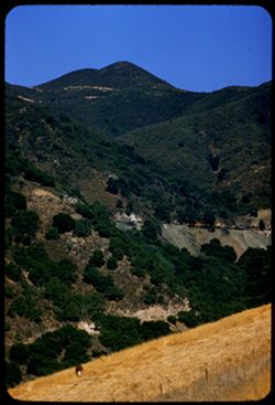
- Description:
- 100 f 6.3 tl
- Subject:
- Canyons, Grasses, Cuesta Pass (Calif.), Trees, Mountains, Shrubs, Railroad passenger cars, Passes (Landforms), Embankments, Railroads, and Southern Pacific R...
- Series:
- 14-57
- Creator:
- Cushman, Charles W., 1896-1972
- Date Created:
- 1957-09-19
- Genre:
- Landscape photographs
- Frame Number:
- 5
- County:
- San Luis Obispo
- Abstract:
- [P] View across Cuesta grade
- Call Number:
- P09504
- Country:
- United States
- State/Province:
- California
- Alternate Identifier:
- 1457.5
- Persistent URL:
- http://purl.dlib.indiana.edu/iudl/archives/cushman/P09504
-
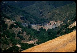
- Description:
- 100 f 4.5 tl
- Subject:
- Embankments, Passes (Landforms), Canyons, Southern Pacific Railroad Company, Railroad passenger cars, Cuesta Pass (Calif.), Mountains, Tunnels, Trees, Railro...
- Series:
- 14-57
- Creator:
- Cushman, Charles W., 1896-1972
- Date Created:
- 1957-09-19
- Genre:
- Landscape photographs and Snapshots
- Frame Number:
- 4
- County:
- San Luis Obispo
- Abstract:
- Sou. Pac. passenger train north bound
- Call Number:
- P09503
- Country:
- United States
- State/Province:
- California
- Alternate Identifier:
- 1457.4
- Persistent URL:
- http://purl.dlib.indiana.edu/iudl/archives/cushman/P09503
-
- Description:
- 100 f 4.5 tl
- Subject:
- Canyons, Grasses, Cuesta Pass (Calif.), Southern Pacific Railroad Company, Mountains, Shrubs, Railroad passenger cars, Passes (Landforms), Embankments, Railr...
- Series:
- 14-57
- Creator:
- Cushman, Charles W., 1896-1972
- Date Created:
- 1957-09-19
- Genre:
- Landscape photographs and Snapshots
- Frame Number:
- 3
- County:
- San Luis Obispo
- Abstract:
- Sou. Pac. passenger train north bound
- Call Number:
- P09502
- Country:
- United States
- State/Province:
- California
- Alternate Identifier:
- 1457.3
- Persistent URL:
- http://purl.dlib.indiana.edu/iudl/archives/cushman/P09502
-
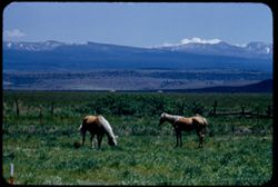
- Description:
- 100 f 6.3 tl
- Subject:
- Snow, Grasses, Grazing, Horses, Trees, Mountains, Fences, Shrubs, and Clouds
- Series:
- 18-55
- Creator:
- Cushman, Charles W., 1896-1972
- Date Created:
- 1955-06-18
- Genre:
- Identification photographs
- Frame Number:
- 16
- County:
- Modoc
- Abstract:
- Blond horses 3.3. mi south of Alturas
- Call Number:
- P08133
- City:
- Alturas
- Country:
- United States
- State/Province:
- California
- Alternate Identifier:
- 1855.16
- Persistent URL:
- http://purl.dlib.indiana.edu/iudl/archives/cushman/P08133
-
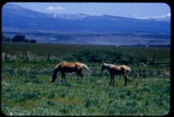
- Description:
- 100 f 6.3 tl
- Subject:
- Horses, Mountains, Shrubs, Snow, Trees, Grazing, Grasses, Fences, and Clouds
- Series:
- 18-55
- Creator:
- Cushman, Charles W., 1896-1972
- Date Created:
- 1955-06-18
- Genre:
- Identification photographs
- Frame Number:
- 15
- County:
- Modoc
- Abstract:
- Blond horses 3.3 mi south of Alturas
- Call Number:
- P08132
- City:
- Alturas
- Country:
- United States
- State/Province:
- California
- Alternate Identifier:
- 1855.15
- Persistent URL:
- http://purl.dlib.indiana.edu/iudl/archives/cushman/P08132
-
- Description:
- 100 f 6.3 tl
- Subject:
- Grasses, Automobiles, Mountains, Shrubs, Railroad tracks, Dwellings, Utility poles, and Electric lines
- Series:
- 18-55
- Creator:
- Cushman, Charles W., 1896-1972
- Date Created:
- 1955-06-18
- Genre:
- Landscape photographs
- Frame Number:
- 11
- Street Address:
- California State Highway 139
- County:
- Modoc
- Abstract:
- Odd slope on other side of Hwy 139
- Call Number:
- P08128
- Country:
- United States
- State/Province:
- California
- Alternate Identifier:
- 1855.11
- Persistent URL:
- http://purl.dlib.indiana.edu/iudl/archives/cushman/P08128
-
- Description:
- 100 f 6.3 tl
- Subject:
- Hills, Bodies of water, Mountains, Shrubs, Snow, Trees, Clouds, Fences, Shasta, Mount (Calif. : Mountain), and Grasses
- Series:
- 18-55
- Creator:
- Cushman, Charles W., 1896-1972
- Date Created:
- 1955-06-17
- Genre:
- Landscape photographs
- Frame Number:
- 2
- County:
- Siskiyou
- Abstract:
- Mt. Shasta at 2:35 from road east of Grenada
- Call Number:
- P08119
- City:
- Grenada
- Country:
- United States
- State/Province:
- California
- Alternate Identifier:
- 1855.2
- Persistent URL:
- http://purl.dlib.indiana.edu/iudl/archives/cushman/P08119
-
- Description:
- 100 f 6.3 tl
- Subject:
- Grasses, Trees, Croplands, Fences, Shrubs, and Mountains
- Series:
- 17-55
- Creator:
- Cushman, Charles W., 1896-1972
- Date Created:
- 1955-06-17
- Genre:
- Landscape photographs
- Frame Number:
- 36
- Street Address:
- United States Highway 99
- County:
- Siskiyou
- Abstract:
- Far-off landscape from US 99 10 mi. NW of Weed
- Call Number:
- P08115
- City:
- Weed
- Country:
- United States
- State/Province:
- California
- Alternate Identifier:
- 1755.36
- Persistent URL:
- http://purl.dlib.indiana.edu/iudl/archives/cushman/P08115
-
- Description:
- 25 f 10
- Subject:
- Grasses, Roads, Madrono, Trees, Flowers, Mountains, Shrubs, Pacific madrone, and Hills
- Series:
- 1-55
- Creator:
- Cushman, Charles W., 1896-1972
- Date Created:
- 1955-01-23
- Genre:
- Identification photographs
- Frame Number:
- 1
- County:
- Sonoma
- Abstract:
- Madrone - Sonoma county north of Bloomfield
- Call Number:
- P07540
- City:
- Bloomfield
- Country:
- United States
- State/Province:
- California
- Alternate Identifier:
- 155.1
- Persistent URL:
- http://purl.dlib.indiana.edu/iudl/archives/cushman/P07540
-
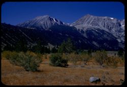
- Description:
- 50 f 9
- Subject:
- Rocks, Grasses, Middle Palisade Glacier (Calif.), Trees, Flowers, Mountains, Shrubs, and Sierra Nevada (Calif. and Nev.)
- Series:
- 12-54
- Creator:
- Cushman, Charles W., 1896-1972
- Date Created:
- 1954-09-18
- Genre:
- Landscape photographs
- Frame Number:
- 10
- County:
- Inyo
- Abstract:
- Again - with yellow.
- Call Number:
- P07400
- City:
- Lone Pine
- Country:
- United States
- State/Province:
- California
- Alternate Identifier:
- 1254.10
- Persistent URL:
- http://purl.dlib.indiana.edu/iudl/archives/cushman/P07400
-
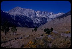
- Description:
- 50 f 10
- Subject:
- Mountains, Shrubs, Sierra Nevada (Calif. and Nev.), and Grasses
- Series:
- 12-54
- Creator:
- Cushman, Charles W., 1896-1972
- Date Created:
- 1954-09-18
- Genre:
- Landscape photographs
- Frame Number:
- 8
- Street Address:
- Glacier Lodge Road
- County:
- Inyo
- Abstract:
- White top of Pyramidal peak - from Glacier Lodge.
- Call Number:
- P07398
- City:
- Big Pine
- Country:
- United States
- State/Province:
- California
- Alternate Identifier:
- 1254.8
- Persistent URL:
- http://purl.dlib.indiana.edu/iudl/archives/cushman/P07398
-
- Description:
- 50 f 11 HF
- Subject:
- Valleys, Grasses, White Mountains (Calif. and Nev.), Trees, Owens Valley (Calif.), Mountains, and Shrubs
- Series:
- 11-54
- Creator:
- Cushman, Charles W., 1896-1972
- Date Created:
- 1954-09-17
- Genre:
- Landscape photographs
- Frame Number:
- 20
- County:
- Inyo
- Abstract:
- White Mtns east wall of Owens Valley with 2 bare trees.
- Call Number:
- P07389
- Country:
- United States
- State/Province:
- California and Nevada
- Alternate Identifier:
- 1154.20
- Persistent URL:
- http://purl.dlib.indiana.edu/iudl/archives/cushman/P07389
-
- Description:
- 50 f 9
- Subject:
- Flowers, Hills, Roads, Mountains, Shrubs, Sierra Nevada (Calif. and Nev.), Trees, Rocks, and Grasses
- Series:
- 11-54
- Creator:
- Cushman, Charles W., 1896-1972
- Date Created:
- 1954-09-17
- Genre:
- Landscape photographs
- Frame Number:
- 5
- Street Address:
- Sabrina Lake Road
- County:
- Inyo
- Abstract:
- High Sierra seen from Sabrina Lake road SW of Bishop.
- Call Number:
- P07374
- City:
- Bishop
- Country:
- United States
- State/Province:
- California
- Alternate Identifier:
- 1154.5
- Persistent URL:
- http://purl.dlib.indiana.edu/iudl/archives/cushman/P07374
-
- Description:
- 50 f 9
- Subject:
- Rocks, Canyons, Grasses, Trees, Flowers, Lee Vining Creek (Calif.), Mountains, Shrubs, and Lee Vining Canyon (Calif.)
- Series:
- 10-54
- Creator:
- Cushman, Charles W., 1896-1972
- Date Created:
- 1954-09-16
- Genre:
- Landscape photographs
- Frame Number:
- 21
- County:
- Mono
- Abstract:
- Another view east down canyon.
- Call Number:
- P07368
- Country:
- United States
- State/Province:
- California
- Physical Description:
- Anscochrome film.
- Alternate Identifier:
- 1054.21
- Persistent URL:
- http://purl.dlib.indiana.edu/iudl/archives/cushman/P07368
-
- Description:
- 50 f 9
- Subject:
- Rocks, Canyons, Grasses, Roads, Yosemite National Park (Calif.), Trees, Pines, Lee Vining Creek (Calif.), Tioga Peak (Calif.), Tioga Pass (Calif.), Mountains...
- Series:
- 9-54
- Creator:
- Cushman, Charles W., 1896-1972
- Date Created:
- 1954-09-16
- Genre:
- Landscape photographs
- Frame Number:
- 30
- Street Address:
- Tioga Pass Road
- County:
- Mono
- Abstract:
- Tioga Peak from east. 11,537 ft.
- Call Number:
- P07341
- Country:
- United States
- State/Province:
- California
- Alternate Identifier:
- 954.30
- Persistent URL:
- http://purl.dlib.indiana.edu/iudl/archives/cushman/P07341
-
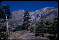
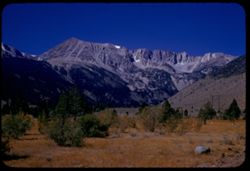
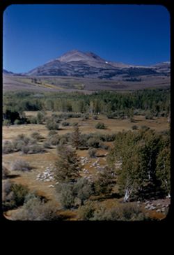
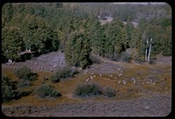
- Description:
- 50 f 10
- Subject:
- Sheep, Lee Vining Creek (Calif.), Deserts, Dana Plateau (Calif.), Roads, Mountains, Yosemite National Park (Calif.), Shrubs, Trees, Rocks, Grazing, Grasses, ...
- Series:
- 9-54
- Creator:
- Cushman, Charles W., 1896-1972
- Date Created:
- 1954-09-16
- Genre:
- Identification photographs
- Frame Number:
- 28
- Street Address:
- Tioga Pass Road
- County:
- Mono
- Abstract:
- Sheep along Tioga Pass road.
- Call Number:
- P07339
- Country:
- United States
- State/Province:
- California
- Physical Description:
- Image was originally mounted in a glass enclosure. Before digitization, the image was removed and placed in a Wess Plastic, Inc. brand, 2" x 2", pl...
- Alternate Identifier:
- 954.28
- Persistent URL:
- http://purl.dlib.indiana.edu/iudl/archives/cushman/P07339
-
- Description:
- 50 f 10
- Subject:
- Lee Vining Creek (Calif.), Deserts, Flowers, Dana, Mount (Calif.), Dana Plateau (Calif.), Roads, Mountains, Yosemite National Park (Calif.), Shrubs, Trees, R...
- Series:
- 9-54
- Creator:
- Cushman, Charles W., 1896-1972
- Date Created:
- 1954-09-16
- Genre:
- Landscape photographs
- Frame Number:
- 27
- County:
- Mono
- Abstract:
- Great east wall of Mt. Dana.
- Call Number:
- P07338
- Country:
- United States
- State/Province:
- California
- Alternate Identifier:
- 954.27
- Persistent URL:
- http://purl.dlib.indiana.edu/iudl/archives/cushman/P07338
-
- Description:
- 50 f 9
- Subject:
- Rocks, Dana Plateau (Calif.), Grasses, Yosemite National Park (Calif.), Trees, Volcanoes, Gibbs, Mount (Calif.), Dana, Mount (Calif.), Mountains, and Shrubs
- Series:
- 9-54
- Creator:
- Cushman, Charles W., 1896-1972
- Date Created:
- 1954-09-16
- Genre:
- Landscape photographs
- Frame Number:
- 26
- Street Address:
- Tioga Pass Road
- County:
- Mono
- Abstract:
- Mt. Gibbs - to south of Dana.
- Call Number:
- P07337
- Country:
- United States
- State/Province:
- California
- Alternate Identifier:
- 954.26
- Persistent URL:
- http://purl.dlib.indiana.edu/iudl/archives/cushman/P07337
-
- Description:
- 50 f 11
- Subject:
- Dana, Mount (Calif.), Mountains, Yosemite National Park (Calif.), Shrubs, Trees, Rocks, Grasses, and Volcanoes
- Series:
- 9-54
- Creator:
- Cushman, Charles W., 1896-1972
- Date Created:
- 1954-09-16
- Genre:
- Landscape photographs
- Frame Number:
- 25
- Street Address:
- Tioga Pass Road
- County:
- Mono
- Abstract:
- Mt. Dana from east. (13,050 elev.)
- Call Number:
- P07336
- Country:
- United States
- State/Province:
- California
- Alternate Identifier:
- 954.25
- Persistent URL:
- http://purl.dlib.indiana.edu/iudl/archives/cushman/P07336
-
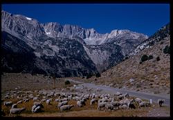
- Description:
- 50 f 9
- Subject:
- Sheep, Hills, Mountains, Shrubs, Sierra Nevada (Calif. and Nev.), Trees, Grazing, Grasses, and Dunderberg Peak (Calif.)
- Series:
- 9-54
- Creator:
- Cushman, Charles W., 1896-1972
- Date Created:
- 1954-09-16
- Genre:
- Landscape photographs
- Frame Number:
- 20
- Street Address:
- United States Highway 395
- County:
- Mono
- Abstract:
- Sheep below - looking toward Dunderberg Pk. (19-20-21 were taken less than mile north of Conway Summit)
- Call Number:
- P07331
- City:
- Bridgeport
- Country:
- United States
- State/Province:
- California
- Physical Description:
- masked.
- Alternate Identifier:
- 954.20
- Persistent URL:
- http://purl.dlib.indiana.edu/iudl/archives/cushman/P07331
-
- Description:
- 50 f 9
- Subject:
- Grasses, Grazing, Trees, Conway Summit (Calif.), Mountains, Shrubs, Sheep, and Hills
- Series:
- 9-54
- Creator:
- Cushman, Charles W., 1896-1972
- Date Created:
- 1954-09-16
- Genre:
- Identification photographs
- Frame Number:
- 19
- Street Address:
- United States Highway 395
- County:
- Mono
- Abstract:
- Sheep below. (19-20-21 were taken less than mile north of Conway Summit)
- Call Number:
- P07330
- City:
- Bridgeport
- Country:
- United States
- State/Province:
- California
- Alternate Identifier:
- 954.19
- Persistent URL:
- http://purl.dlib.indiana.edu/iudl/archives/cushman/P07330
-
- Description:
- 50 f 8
- Subject:
- Grasses, Trees, Shadows, Buttes, Mountains, Rock formations, Sonora Peak (Calif.), and Shrubs
- Series:
- 9-54
- Creator:
- Cushman, Charles W., 1896-1972
- Date Created:
- 1954-09-15
- Genre:
- Landscape photographs
- Frame Number:
- 7
- Street Address:
- Sonora Pass Road
- County:
- Tuolumne
- Abstract:
- Up at sun lit escarpment east of Dardanelle.
- Call Number:
- P07318
- City:
- Dardanelle
- Country:
- United States
- State/Province:
- California
- Alternate Identifier:
- 954.7
- Persistent URL:
- http://purl.dlib.indiana.edu/iudl/archives/cushman/P07318
-
- Description:
- 50 f 8
- Subject:
- Rocks, Grasses, Trees, Buttes, Stanislaus River (Calif.), Mountains, Rock formations, and Shrubs
- Series:
- 9-54
- Creator:
- Cushman, Charles W., 1896-1972
- Date Created:
- 1954-09-15
- Genre:
- Landscape photographs
- Frame Number:
- 6
- Street Address:
- California State Highway 108
- County:
- Tuolumne
- Abstract:
- Looking up at granite ridge from Hwy 108 far below. 5:30 PM.
- Call Number:
- P07317
- City:
- Dardanelle
- Country:
- United States
- State/Province:
- California
- Alternate Identifier:
- 954.6
- Persistent URL:
- http://purl.dlib.indiana.edu/iudl/archives/cushman/P07317
-
- Description:
- 50 f 8
- Subject:
- Rocks, Stanislaus River Canyon (Calif.), Grasses, Trees, Buttes, Mountains, Shrubs, and Rock formations
- Series:
- 9-54
- Creator:
- Cushman, Charles W., 1896-1972
- Date Created:
- 1954-09-15
- Genre:
- Landscape photographs
- Frame Number:
- 5
- Street Address:
- California State Highway 108
- County:
- Tuolumne
- Abstract:
- Looking up at granite ridge from Hwy 108 far below. 5:30 PM.
- Call Number:
- P07316
- City:
- Dardanelle
- Country:
- United States
- State/Province:
- California
- Alternate Identifier:
- 954.5
- Persistent URL:
- http://purl.dlib.indiana.edu/iudl/archives/cushman/P07316
-
- Description:
- 50 f 9
- Subject:
- Snow, Cascade Range, Grasses, Trees, Volcanoes, Lassen Volcanic National Park (Calif.), Mountains, Shrubs, Mount Shasta (Calif. : Mountain), and Stratovolcanoes
- Series:
- 7-54
- Creator:
- Cushman, Charles W., 1896-1972
- Date Created:
- 1954-08-21
- Genre:
- Landscape photographs
- Frame Number:
- 2
- Street Address:
- California State Highway 89
- County:
- Siskiyou
- Abstract:
- Mt Shasta from Cal. 89 on SE.
- Call Number:
- P07258
- Country:
- United States
- State/Province:
- California
- Physical Description:
- Image was originally mounted in a glass enclosure. Before digitization, the image was removed and placed in a Wess Plastic, Inc. brand, 2" x 2", pl...
- Alternate Identifier:
- 754.2
- Persistent URL:
- http://purl.dlib.indiana.edu/iudl/archives/cushman/P07258
-
- Description:
- 50 f 10
- Subject:
- Snow, Cascade Range, Grasses, Trees, Volcanoes, Stratovolcanoes, Mountains, Shrubs, Mount Shasta (Calif. : Mountain), and Lassen Volcanic National Park (Calif.)
- Series:
- 7-54
- Creator:
- Cushman, Charles W., 1896-1972
- Date Created:
- 1954-08-21
- Genre:
- Landscape photographs
- Frame Number:
- 1
- Street Address:
- California State Highway 89
- County:
- Siskiyou
- Abstract:
- Mt Shasta from Cal. 89 on SE.
- Call Number:
- P07257
- Country:
- United States
- State/Province:
- California
- Alternate Identifier:
- 754.1
- Persistent URL:
- http://purl.dlib.indiana.edu/iudl/archives/cushman/P07257
-
- Description:
- 50 f 9
- Subject:
- Rocks, Cascade Range, Grasses, Trees, Flowers, Lassen Volcanic National Park (Calif.), Mountains, Shrubs, and Lupines
- Series:
- 6-54
- Creator:
- Cushman, Charles W., 1896-1972
- Date Created:
- 1954-08-19
- Genre:
- Landscape photographs
- Frame Number:
- 9
- County:
- Shasta
- Abstract:
- Lupine on slope.
- Call Number:
- P07227
- Country:
- United States
- State/Province:
- California
- Alternate Identifier:
- 654.9
- Persistent URL:
- http://purl.dlib.indiana.edu/iudl/archives/cushman/P07227
-
- Description:
- 50 f 9
- Subject:
- Bodies of water, Weeds, Fishing, Mountains, Shrubs, Lakes & ponds, Clouds, People, Clear Lake (Lake County, Calif.), Grasses, and Plants
- Series:
- 4-54
- Creator:
- Cushman, Charles W., 1896-1972
- Date Created:
- 1954-08-13
- Genre:
- Landscape photographs
- Frame Number:
- 17
- County:
- Lake
- Abstract:
- Clear Lake
- Call Number:
- P07191
- Country:
- United States
- State/Province:
- California
- Physical Description:
- Anscochrome film.
- Alternate Identifier:
- 454.17
- Persistent URL:
- http://purl.dlib.indiana.edu/iudl/archives/cushman/P07191
-
- Description:
- 50 f 8
- Subject:
- Wildflowers, Bays (Bodies of water), Richardson Bay Bridge (Calif.), Grasses, Trees, Mountains, Richardson Bay (Calif.), Shrubs, Tamalpais, Mount (Calif.), H...
- Series:
- 4-54
- Creator:
- Cushman, Charles W., 1896-1972
- Date Created:
- 1954-08-13
- Genre:
- Cityscape photographs
- Frame Number:
- 14
- Street Address:
- United States Highway 101
- County:
- Marin
- Abstract:
- Mt. Tamalpais from US101- Richardson Bay bridge
- Call Number:
- P07188
- Country:
- United States
- State/Province:
- California
- Physical Description:
- Anscochrome film.
- Alternate Identifier:
- 454.14
- Persistent URL:
- http://purl.dlib.indiana.edu/iudl/archives/cushman/P07188
-
- Description:
- 50 f 9 haze filter
- Subject:
- Croplands, Meadows, Hills, Roads, Mountains, Shrubs, Trees, Rocks, Grasses, Fences, and Salmon Creek (Marin County, Calif.)
- Series:
- 4-54
- Creator:
- Cushman, Charles W., 1896-1972
- Date Created:
- 1954-07-29
- Genre:
- Landscape photographs
- Frame Number:
- 12
- County:
- Marin
- Abstract:
- Dry pasture land - outcrop in center, dark green mtn in background along Salmon creek [ad in Main]
- Call Number:
- P07186
- Country:
- United States
- State/Province:
- California
- Physical Description:
- Anscochrome film.
- Alternate Identifier:
- 454.12
- Persistent URL:
- http://purl.dlib.indiana.edu/iudl/archives/cushman/P07186
-
- Description:
- 50 f 9
- Subject:
- Grasses, Grazing, Trees, Meadows, Mountains, Fences, Shrubs, and Tamalpais, Mount (Calif.)
- Series:
- 4-54
- Creator:
- Cushman, Charles W., 1896-1972
- Date Created:
- 1954-07-29
- Genre:
- Landscape photographs
- Frame Number:
- 10
- County:
- Marin
- Abstract:
- Tamalpais from SW.
- Call Number:
- P07184
- Country:
- United States
- State/Province:
- California
- Physical Description:
- Anscochrome film.
- Alternate Identifier:
- 454.10
- Persistent URL:
- http://purl.dlib.indiana.edu/iudl/archives/cushman/P07184
-
- Description:
- 50 f 9
- Subject:
- Straw flowers, Grasses, Trees, Flowers, Meadows, Mountains, Shrubs, and Half Moon Bay (Calif.)
- Series:
- 4-54
- Creator:
- Cushman, Charles W., 1896-1972
- Date Created:
- 1954-07-22
- Genre:
- Landscape photographs
- Frame Number:
- 5
- Street Address:
- California State Highway 1
- County:
- San Mateo
- Abstract:
- Field of straw flowers with mtns in distance - along Hwy 1near Half Moon Bay
- Call Number:
- P07179
- Country:
- United States
- State/Province:
- California
- Physical Description:
- Anscochrome film.
- Alternate Identifier:
- 454.5
- Persistent URL:
- http://purl.dlib.indiana.edu/iudl/archives/cushman/P07179
-
- Description:
- 50 f 9
- Subject:
- Grasses, Grazing, Farms, Trees, Cattle, Mountains, Shrubs, Cows, Black Mountain (Marin County, Calif.), and Hills
- Series:
- 2-54
- Creator:
- Cushman, Charles W., 1896-1972
- Date Created:
- 1954-05-21
- Genre:
- Landscape photographs
- Frame Number:
- 5
- County:
- Marin
- Abstract:
- Cows graze below Black Mtn. - Marin county
- Call Number:
- P07136
- Country:
- United States
- State/Province:
- California
- Alternate Identifier:
- 254.5
- Persistent URL:
- http://purl.dlib.indiana.edu/iudl/archives/cushman/P07136
-
- Description:
- 50 f 10
- Subject:
- Deserts, Mojave Desert (Calif.), Grasses, Houses, Mountains, Shrubs, and Hills
- Series:
- 16-53
- Creator:
- Cushman, Charles W., 1896-1972
- Date Created:
- 1953-11-23
- Genre:
- Landscape photographs
- Frame Number:
- 15
- Street Address:
- United States Highway 6
- County:
- Kern
- Abstract:
- Desert mountain in color. Near Rosamond
- Call Number:
- P07087
- City:
- Rosamond
- Country:
- United States
- State/Province:
- California
- Alternate Identifier:
- 1653.15
- Persistent URL:
- http://purl.dlib.indiana.edu/iudl/archives/cushman/P07087
-
- Description:
- 50 f 9
- Subject:
- Farmhouses, Farms, Trees, Log cabins, Mountains, Fences, Shrubs, Grasses, and Rock formations
- Series:
- 15-53
- Creator:
- Cushman, Charles W., 1896-1972
- Date Created:
- 1953-11-21
- Genre:
- Landscape photographs
- Frame Number:
- 23
- County:
- Coconino
- Abstract:
- Log cabin & high wall near Sedona
- Call Number:
- P07056
- City:
- Sedona
- Country:
- United States
- State/Province:
- Arizona
- Alternate Identifier:
- 1553.23
- Persistent URL:
- http://purl.dlib.indiana.edu/iudl/archives/cushman/P07056
-
- Description:
- 50 f 6.3 POLA
- Subject:
- Grasses, Cliffs, Mesas, Mountains, Fences, Shrubs, Clouds, Hills, and Trees
- Series:
- 15-53
- Creator:
- Cushman, Charles W., 1896-1972
- Date Created:
- 1953-11-21
- Genre:
- Landscape photographs
- Frame Number:
- 18
- Street Address:
- United States Highway 89A
- County:
- Coconino
- Abstract:
- View North
- Call Number:
- P07051
- City:
- Sedona
- Country:
- United States
- State/Province:
- Arizona
- Alternate Identifier:
- 1553.18
- Persistent URL:
- http://purl.dlib.indiana.edu/iudl/archives/cushman/P07051
-
- Description:
- 50 f 6.3 POLA
- Subject:
- Grasses, Cliffs, Trees, Mountains, Shrubs, Hills, Mesas, and Rock formations
- Series:
- 15-53
- Creator:
- Cushman, Charles W., 1896-1972
- Date Created:
- 1953-11-21
- Genre:
- Landscape photographs
- Frame Number:
- 17
- Street Address:
- United States Highway 89A
- County:
- Coconino
- Abstract:
- View NE.
- Call Number:
- P07050
- City:
- Sedona
- Country:
- United States
- State/Province:
- Arizona
- Alternate Identifier:
- 1553.17
- Persistent URL:
- http://purl.dlib.indiana.edu/iudl/archives/cushman/P07050
-
- Description:
- 50 f 6.3
- Subject:
- Hills, Mountains, Shrubs, Snow, Mingus Mountain (Ariz.), Grasses, and Rocks
- Series:
- 15-53
- Creator:
- Cushman, Charles W., 1896-1972
- Date Created:
- 1953-11-21
- Genre:
- Landscape photographs and Cityscape photographs
- Frame Number:
- 15
- County:
- Yavapai
- Abstract:
- Looking back toward Jerome and Mingus Mtn from Clarkdale
- Call Number:
- P07049
- City:
- Clarkdale and Jerome
- Country:
- United States
- State/Province:
- Arizona
- Physical Description:
- Image was originally mounted in a glass enclosure. Before digitization, the image was removed and placed in a Wess Plastic, Inc. brand, 2" x 2", pl...
- Alternate Identifier:
- 1553.15
- Persistent URL:
- http://purl.dlib.indiana.edu/iudl/archives/cushman/P07049
-
- Description:
- 50 f 9
- Subject:
- Grasses, Rock mass, Mountains, Rock formations, Hills, and Shrubs
- Series:
- 14-53
- Creator:
- Cushman, Charles W., 1896-1972
- Date Created:
- 1953-11-19
- Genre:
- Landscape photographs
- Frame Number:
- 37
- Street Address:
- United States Highway 60 and United States Highway 70
- County:
- Pinal
- Abstract:
- Rock mass west of Superior
- Call Number:
- P07033
- City:
- Superior
- Country:
- United States
- State/Province:
- Arizona
- Alternate Identifier:
- 1453.37
- Persistent URL:
- http://purl.dlib.indiana.edu/iudl/archives/cushman/P07033
-
- Description:
- 50 f 11
- Subject:
- Mountains, Shrubs, Rocks, Grasses, Chimney rocks, and Rock formations
- Series:
- 14-53
- Creator:
- Cushman, Charles W., 1896-1972
- Date Created:
- 1953-11-19
- Genre:
- Identification photographs and Landscape photographs
- Frame Number:
- 23
- Street Address:
- United States Highway 70 and United States Highway 60
- County:
- Pinal
- Abstract:
- Row of high chimney rocks above old road
- Call Number:
- P07019
- City:
- Superior
- Country:
- United States
- State/Province:
- Arizona
- Alternate Identifier:
- 1453.23
- Persistent URL:
- http://purl.dlib.indiana.edu/iudl/archives/cushman/P07019
-
- Description:
- 50 f 9
- Subject:
- Rocks, Grasses, Roads, Tree limbs, Mountains, Rock formations, and Shrubs
- Series:
- 14-53
- Creator:
- Cushman, Charles W., 1896-1972
- Date Created:
- 1953-11-19
- Genre:
- Landscape photographs
- Frame Number:
- 22
- Street Address:
- United States Highway 60 and United States Highway 70
- County:
- Pinal
- Abstract:
- a stretch of the old highway
- Call Number:
- P07018
- City:
- Superior
- Country:
- United States
- State/Province:
- Arizona
- Alternate Identifier:
- 1453.22
- Persistent URL:
- http://purl.dlib.indiana.edu/iudl/archives/cushman/P07018
-
- Description:
- 50 f 10
- Subject:
- Roads, Bridges, Mountains, Shrubs, Rocks, Railings, Grasses, and Rock formations
- Series:
- 14-53
- Creator:
- Cushman, Charles W., 1896-1972
- Date Created:
- 1953-11-19
- Genre:
- Landscape photographs and Views
- Frame Number:
- 21
- Street Address:
- United States Highway 70 and United States Highway 60
- County:
- Pinal
- Abstract:
- 1936 scene
- Call Number:
- P07017
- City:
- Superior
- Country:
- United States
- State/Province:
- Arizona
- Alternate Identifier:
- 1453.21
- Persistent URL:
- http://purl.dlib.indiana.edu/iudl/archives/cushman/P07017
-
- Description:
- 50 f 11
- Subject:
- Automobiles, Roads, Mountains, Shrubs, Rocks, Railings, Grasses, Shadows, and Rock formations
- Series:
- 14-53
- Creator:
- Cushman, Charles W., 1896-1972
- Date Created:
- 1953-11-19
- Genre:
- Identification photographs and Landscape photographs
- Frame Number:
- 20
- Street Address:
- United States Highway 70 and United States Highway 60
- County:
- Pinal
- Abstract:
- Rock shapes along west slope
- Call Number:
- P07016
- City:
- Superior
- Country:
- United States
- State/Province:
- Arizona
- Alternate Identifier:
- 1453.20
- Persistent URL:
- http://purl.dlib.indiana.edu/iudl/archives/cushman/P07016
-
- Description:
- 50 f 9
- Subject:
- Rocks, Grasses, Trees, Boulders, Mountains, Shrubs, and Rock formations
- Series:
- 14-53
- Creator:
- Cushman, Charles W., 1896-1972
- Date Created:
- 1953-11-19
- Genre:
- Landscape photographs and Identification photographs
- Frame Number:
- 19
- Street Address:
- United States Highway 60 and United States Highway 70
- County:
- Pinal and Gila
- Abstract:
- Rock Mass reminissent of 17 yrs. Ago
- Call Number:
- P07015
- City:
- Superior and Miami
- Country:
- United States
- State/Province:
- Arizona
- Alternate Identifier:
- 1453.19
- Persistent URL:
- http://purl.dlib.indiana.edu/iudl/archives/cushman/P07015
-
- Description:
- 50 f 9
- Subject:
- Rocks, Grasses, Trees, Boulders, Mountains, Shrubs, and Rock formations
- Series:
- 14-53
- Creator:
- Cushman, Charles W., 1896-1972
- Date Created:
- 1953-11-19
- Genre:
- Landscape photographs and Identification photographs
- Frame Number:
- 18
- Street Address:
- United States Highway 60 and United States Highway 70
- County:
- Pinal and Gila
- Abstract:
- Rock Mass reminissent of 17 yrs. Ago
- Call Number:
- P07014
- City:
- Superior and Miami
- Country:
- United States
- State/Province:
- Arizona
- Alternate Identifier:
- 1453.18
- Persistent URL:
- http://purl.dlib.indiana.edu/iudl/archives/cushman/P07014
-
- Description:
- 50 f 8 POLA
- Subject:
- Rocks, Grasses, Pinal Mountains (Ariz.), Mining, Dirt, Mountains, Shrubs, Lakes & ponds, and Castle Dome mine (Gila County, Ariz.)
- Series:
- 14-53
- Creator:
- Cushman, Charles W., 1896-1972
- Date Created:
- 1953-11-19
- Genre:
- Landscape photographs
- Frame Number:
- 14
- Street Address:
- United States Highway 60 and United States Highway 70
- County:
- Gila
- Abstract:
- Toward Castle Dome Mine from higher up
- Call Number:
- P07010
- City:
- Miami
- Country:
- United States
- State/Province:
- Arizona
- Alternate Identifier:
- 1453.14
- Persistent URL:
- http://purl.dlib.indiana.edu/iudl/archives/cushman/P07010
-
- Description:
- 50 f 6.3 POLA
- Subject:
- Grasses, Mountains, Shrubs, and Hills
- Series:
- 14-53
- Creator:
- Cushman, Charles W., 1896-1972
- Date Created:
- 1953-11-19
- Genre:
- Landscape photographs
- Frame Number:
- 1
- County:
- Gila
- Abstract:
- Mountain range north of Miami
- Call Number:
- P06997
- City:
- Miami
- Country:
- United States
- State/Province:
- Arizona
- Alternate Identifier:
- 1453.1
- Persistent URL:
- http://purl.dlib.indiana.edu/iudl/archives/cushman/P06997
-
- Description:
- 50 f 3.5 Pola
- Subject:
- Grasses, Storms, Mountains, Shrubs, Whitlock Mountains (Ariz.), Clouds, and Rain
- Series:
- 13-53
- Creator:
- Cushman, Charles W., 1896-1972
- Date Created:
- 1953-11-18
- Genre:
- Landscape photographs
- Frame Number:
- 27
- Street Address:
- United States Highway 70
- County:
- Graham and Greenlee
- Abstract:
- Storm clouds moving from west toward Whitlock Mtn
- Call Number:
- P06984
- City:
- Duncan and Safford
- Country:
- United States
- State/Province:
- Arizona
- Alternate Identifier:
- 1353.27
- Persistent URL:
- http://purl.dlib.indiana.edu/iudl/archives/cushman/P06984
-
- Description:
- 50 f 9
- Subject:
- Rocks, Grasses, Buttes, Mountains, Shrubs, and Hills
- Series:
- 13-53
- Creator:
- Cushman, Charles W., 1896-1972
- Date Created:
- 1953-11-18
- Genre:
- Landscape photographs
- Frame Number:
- 23
- Street Address:
- United States Highway 70
- County:
- Graham and Greenlee
- Abstract:
- Fine mtn north of US 70 halfway between Duncan & Safford
- Call Number:
- P06980
- City:
- Duncan and Safford
- Country:
- United States
- State/Province:
- Arizona
- Alternate Identifier:
- 1353.23
- Persistent URL:
- http://purl.dlib.indiana.edu/iudl/archives/cushman/P06980
-
- Description:
- 50 f 8
- Subject:
- Quitman Mountains (Tex.), Mountains, Shrubs, Rocks, and Grasses
- Series:
- 12-53
- Creator:
- Cushman, Charles W., 1896-1972
- Date Created:
- 1953-11-15
- Genre:
- Landscape photographs
- Frame Number:
- 37
- Street Address:
- United States Highway 80
- County:
- El Paso and Hudspeth
- Abstract:
- Quitman Mtns from loop of US 80 - 75 mi. from El Paso
- Call Number:
- P06955
- City:
- El Paso
- Country:
- United States
- State/Province:
- Texas
- Alternate Identifier:
- 1253.37
- Persistent URL:
- http://purl.dlib.indiana.edu/iudl/archives/cushman/P06955
-
- Description:
- 50 f 8
- Subject:
- Plains, Mountains, Dirt roads, Shrubs, Sierra Blanca Mountains (Tex.), and Grasses
- Series:
- 12-53
- Creator:
- Cushman, Charles W., 1896-1972
- Date Created:
- 1953-11-15
- Genre:
- Landscape photographs
- Frame Number:
- 36
- County:
- Hudspeth
- Abstract:
- Sierra Blanca Mtn. (7000 ft)
- Call Number:
- P06954
- City:
- Sierra Blanca
- Country:
- United States
- State/Province:
- Texas
- Alternate Identifier:
- 1253.36
- Persistent URL:
- http://purl.dlib.indiana.edu/iudl/archives/cushman/P06954
-
- Description:
- 50 f 4.5 POLA
- Subject:
- Grasses, Gomez Peak (Tex.), Shrubs, Hills, and Mountains
- Series:
- 12-53
- Creator:
- Cushman, Charles W., 1896-1972
- Date Created:
- 1953-11-15
- Genre:
- Landscape photographs
- Frame Number:
- 35
- Street Address:
- United States Highway 80 and United States Highway 290
- County:
- Jeff Davis
- Abstract:
- Gomez Pk (6323) from US 80 west of intersection US 80-290
- Call Number:
- P06953
- Country:
- United States
- State/Province:
- Texas
- Alternate Identifier:
- 1253.35
- Persistent URL:
- http://purl.dlib.indiana.edu/iudl/archives/cushman/P06953
-
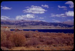
- Description:
- 50 f 11
- Subject:
- Reservoirs, Houses, Trees, Mountains, Shrubs, Lakes & ponds, Clouds, Twin Lakes Reservoir (Lake County, Colo.), Hills, Grasses, and Waterfronts
- Series:
- 11-53
- Creator:
- Cushman, Charles W., 1896-1972
- Date Created:
- 1953-10-15
- Genre:
- Landscape photographs
- Frame Number:
- 16
- County:
- Lake
- Abstract:
- The bigger Twin Lakes
- Call Number:
- P06895
- City:
- Leadville
- Country:
- United States
- State/Province:
- Colorado
- Alternate Identifier:
- 1153.16
- Persistent URL:
- http://purl.dlib.indiana.edu/iudl/archives/cushman/P06895
-
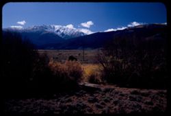
- Description:
- 50 f 11
- Subject:
- Grasses, Houses, Dirt, Meadows, Mountains, Massive, Mount (Colo.), Shrubs, Clouds, Hills, and Fences
- Series:
- 11-53
- Creator:
- Cushman, Charles W., 1896-1972
- Date Created:
- 1953-10-15
- Genre:
- Landscape photographs
- Frame Number:
- 7
- Street Address:
- United States Highway 24
- County:
- Lake
- Abstract:
- Mt. Massive 14, 418 from US 24 just South of Leadville, Colorado
- Call Number:
- P06886
- City:
- Leadville
- Country:
- United States
- State/Province:
- Colorado
- Alternate Identifier:
- 1153.7
- Persistent URL:
- http://purl.dlib.indiana.edu/iudl/archives/cushman/P06886
-
- Description:
- 50 f 9 Pola
- Subject:
- Snow, Grasses, Grazing, Meadows, Cattle, Mountains, Fences, Shrubs, Clouds, Hills, and Elbert, Mount (Colo.)
- Series:
- 11-53
- Creator:
- Cushman, Charles W., 1896-1972
- Date Created:
- 1953-10-15
- Genre:
- Landscape photographs
- Frame Number:
- 5
- County:
- Lake
- Abstract:
- Mt. Elbert from east
- Call Number:
- P06884
- City:
- Leadville
- Country:
- United States
- State/Province:
- Colorado
- Physical Description:
- Image was originally mounted in a glass enclosure. Before digitization, the image was removed and placed in a Wess Plastic, Inc. brand, 2" x 2", pl...
- Alternate Identifier:
- 1153.5
- Persistent URL:
- http://purl.dlib.indiana.edu/iudl/archives/cushman/P06884
-
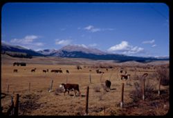
- Description:
- 50 f 11
- Subject:
- Meadows, Hills, Mountains, Shrubs, Grazing, Barns, Clouds, Fences, Cattle, Massive, Mount (Colo.), and Grasses
- Series:
- 11-53
- Creator:
- Cushman, Charles W., 1896-1972
- Date Created:
- 1953-10-15
- Genre:
- Views
- Frame Number:
- 4
- County:
- Lake
- Abstract:
- Mt. Massive from SE
- Call Number:
- P06883
- City:
- Leadville
- Country:
- United States
- State/Province:
- Colorado
- Alternate Identifier:
- 1153.4
- Persistent URL:
- http://purl.dlib.indiana.edu/iudl/archives/cushman/P06883
-
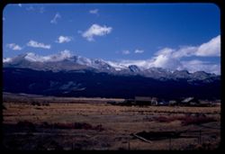
- Description:
- 50 f 7 Pola
- Subject:
- Harvard, Mount (Colo.), Meadows, Hills, Mountains, Shrubs, Snow, Trees, Shadows, Trails & paths, Clouds, Utility poles, and Grasses
- Series:
- 10-53
- Creator:
- Cushman, Charles W., 1896-1972
- Date Created:
- 1953-10-15
- Genre:
- Landscape photographs
- Frame Number:
- 38
- Street Address:
- United States Highway 24
- County:
- Pitkin
- Abstract:
- Snow crowned Mount Harvard from the Aspen road
- Call Number:
- P06878
- City:
- Aspen
- Country:
- United States
- State/Province:
- Colorado
- Alternate Identifier:
- 1053.38
- Persistent URL:
- http://purl.dlib.indiana.edu/iudl/archives/cushman/P06878
-
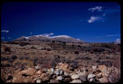
- Description:
- 50 f 8 Pola
- Subject:
- Rocks, Grasses, Mountains, Shrubs, Clouds, Elbert, Mount (Colo.), and Hills
- Series:
- 10-53
- Creator:
- Cushman, Charles W., 1896-1972
- Date Created:
- 1953-10-15
- Genre:
- Landscape photographs
- Frame Number:
- 37
- Street Address:
- United States Highway 24
- County:
- Chaffee
- Abstract:
- Mt. Elbert from US 24 north of Granite
- Call Number:
- P06877
- City:
- Granite
- Country:
- United States
- State/Province:
- Colorado
- Alternate Identifier:
- 1053.37
- Persistent URL:
- http://purl.dlib.indiana.edu/iudl/archives/cushman/P06877
-
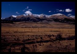
- Subject:
- Antero, Mount (Colo.), Grasses, Trees, Meadows, Mountains, Shrubs, Clouds, Passes (Landforms), and Trout Creek Pass (Colo.)
- Series:
- 10-53
- Creator:
- Cushman, Charles W., 1896-1972
- Date Created:
- 1953-10-15
- Genre:
- Landscape photographs
- Frame Number:
- 35
- Street Address:
- United States Highway 24
- County:
- Chaffee
- Abstract:
- Also Mt. Antero (same)
- Call Number:
- P06875
- Country:
- United States
- State/Province:
- Colorado
- Physical Description:
- Image was originally mounted in a glass enclosure. Before digitization, the image was removed and placed in a Wess Plastic, Inc. brand, 2" x 2", pl...
- Alternate Identifier:
- 1053.35
- Persistent URL:
- http://purl.dlib.indiana.edu/iudl/archives/cushman/P06875
-
- Description:
- 50 f 7 Pola
- Subject:
- Grasses, Trees, Meadows, Mountains, Shrubs, Clouds, Hills, and Yale, Mount (Colo.)
- Series:
- 10-53
- Creator:
- Cushman, Charles W., 1896-1972
- Date Created:
- 1953-10-15
- Genre:
- Landscape photographs
- Frame Number:
- 36
- Street Address:
- United States Highway 24
- County:
- Chaffee
- Abstract:
- Mt Yale form US 24 north of Buena Vista
- Call Number:
- P06876
- City:
- Buena Vista
- Country:
- United States
- State/Province:
- Colorado
- Alternate Identifier:
- 1053.36
- Persistent URL:
- http://purl.dlib.indiana.edu/iudl/archives/cushman/P06876
-
- Description:
- 50 f 8 Pola
- Subject:
- Grasses, Trees, Meadows, Mountains, Shrubs, Clouds, Hills, and Yale, Mount (Colo.)
- Series:
- 10-53
- Creator:
- Cushman, Charles W., 1896-1972
- Date Created:
- 1953-10-15
- Genre:
- Landscape photographs
- Frame Number:
- 33
- Street Address:
- United States Highway 24
- County:
- Chaffee
- Abstract:
- Mt. Yale
- Call Number:
- P06873
- Country:
- United States
- State/Province:
- Colorado
- Alternate Identifier:
- 1053.33
- Persistent URL:
- http://purl.dlib.indiana.edu/iudl/archives/cushman/P06873
-
- Description:
- 50 f 8 Pola
- Subject:
- Railings, Grasses, Roads, Trees, Meadows, Mountains, Shrubs, Clouds, Passes (Landforms), Trout Creek Pass (Colo.), Princeton, Mount (Colo.), and Hills
- Series:
- 10-53
- Creator:
- Cushman, Charles W., 1896-1972
- Date Created:
- 1953-10-15
- Genre:
- Landscape photographs
- Frame Number:
- 32
- Street Address:
- United States Highway 24
- County:
- Chaffee
- Abstract:
- Mt. Princeton
- Call Number:
- P06872
- Country:
- United States
- State/Province:
- Colorado
- Physical Description:
- Image was originally mounted in a glass enclosure. Before digitization, the image was removed and placed in a Wess Plastic, Inc. brand, 2" x 2", pl...
- Alternate Identifier:
- 1053.32
- Persistent URL:
- http://purl.dlib.indiana.edu/iudl/archives/cushman/P06872
-
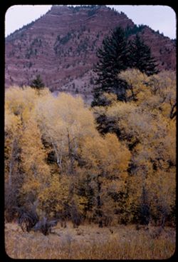
- Description:
- 50 f 4.5
- Subject:
- Grasses, Trees, Mountains, Shrubs, Autumn, and Erosion
- Series:
- 10-53
- Creator:
- Cushman, Charles W., 1896-1972
- Date Created:
- 1953-10-13
- Genre:
- Landscape photographs
- Frame Number:
- 6
- Street Address:
- United States Highway 6
- County:
- Eagle
- Abstract:
- Yellow trees & red Mountain from US 6 east of Eagle [P]
- Call Number:
- P06846
- City:
- Eagle
- Country:
- United States
- State/Province:
- Colorado
- Alternate Identifier:
- 1053.6
- Persistent URL:
- http://purl.dlib.indiana.edu/iudl/archives/cushman/P06846
-
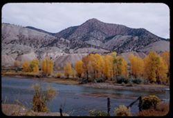
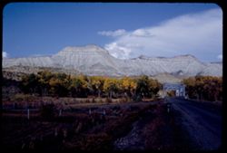
- Description:
- 50 f 8
- Subject:
- Houses, Dirt, Mountains, Shrubs, Trees, Rocks, Colorado River (Colo.-Mexico), Rivers, Fences, Hills, and Grasses
- Series:
- 10-53
- Creator:
- Cushman, Charles W., 1896-1972
- Date Created:
- 1953-10-13
- Genre:
- Landscape photographs
- Frame Number:
- 4
- County:
- Eagle
- Abstract:
- Colorado river near Dotsero
- Call Number:
- P06844
- City:
- Dotsero
- Country:
- United States
- State/Province:
- Colorado
- Alternate Identifier:
- 1053.4
- Persistent URL:
- http://purl.dlib.indiana.edu/iudl/archives/cushman/P06844
-
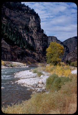
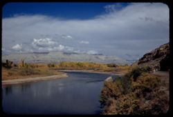
- Description:
- 50 f 8
- Subject:
- Rocks, Valleys, Grasses, Cliffs, Trees, Pines, Mountains, Shrubs, Rivers, Glenwood Canyon (Colo.), Canyons, and Colorado River (Colo.-Mexico)
- Series:
- 9-53
- Creator:
- Cushman, Charles W., 1896-1972
- Date Created:
- 1953-10-13
- Frame Number:
- 39
- County:
- Garfield
- Abstract:
- Glenwood canyon
- Call Number:
- P06840
- City:
- Glenwood Springs
- Country:
- United States
- State/Province:
- Colorado
- Alternate Identifier:
- 953.39
- Persistent URL:
- http://purl.dlib.indiana.edu/iudl/archives/cushman/P06840
-
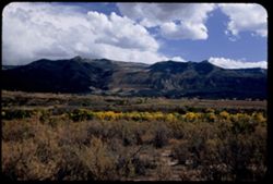
- Description:
- 50 f 6.3 Pola
- Subject:
- Valleys, Hills, Mountains, Shrubs, Grasses, and Clouds
- Series:
- 9-53
- Creator:
- Cushman, Charles W., 1896-1972
- Date Created:
- 1953-10-12
- Genre:
- Landscape photographs
- Frame Number:
- 36
- County:
- Garfield
- Abstract:
- Looking south across Grand Valley at 2:10
- Call Number:
- P06837
- City:
- Parachute
- Country:
- United States
- State/Province:
- Colorado
- Alternate Identifier:
- 953.36
- Persistent URL:
- http://purl.dlib.indiana.edu/iudl/archives/cushman/P06837
-
- Description:
- 50 f 11
- Subject:
- Grasses, Roads, Trees, Mountains, Fences, Shrubs, Clouds, Hills, Cliffs, and Bridges
- Series:
- 9-53
- Creator:
- Cushman, Charles W., 1896-1972
- Date Created:
- 1953-10-12
- Genre:
- Landscape photographs
- Frame Number:
- 35
- County:
- Mesa
- Abstract:
- Mtns near De Beque
- Call Number:
- P06836
- City:
- De Beque
- Country:
- United States
- State/Province:
- Colorado
- Alternate Identifier:
- 953.35
- Persistent URL:
- http://purl.dlib.indiana.edu/iudl/archives/cushman/P06836
-
- Description:
- 50 f 8 Pola
- Subject:
- Rocks, Canyons, Grasses, Roads, Automobiles, Mesas, Colorado River (Colo.-Mexico), Mountains, Shrubs, Clouds, Hills, Rivers, and Trees
- Series:
- 9-53
- Creator:
- Cushman, Charles W., 1896-1972
- Date Created:
- 1953-10-12
- Genre:
- Landscape photographs
- Frame Number:
- 34
- County:
- Mesa
- Abstract:
- View north up river around bend
- Call Number:
- P06835
- City:
- Grand Junction
- Country:
- United States
- State/Province:
- Colorado
- Alternate Identifier:
- 953.34
- Persistent URL:
- http://purl.dlib.indiana.edu/iudl/archives/cushman/P06835
-
- Description:
- 50 f 11
- Subject:
- Canyons, Hills, Roads, Mountains, Shrubs, Rocks, Colorado River (Colo.-Mexico), Grasses, Mesas, Horseshoe Canyon (Colo.), Clouds, and Rivers
- Series:
- 9-53
- Creator:
- Cushman, Charles W., 1896-1972
- Date Created:
- 1953-10-12
- Genre:
- Landscape photographs
- Frame Number:
- 33
- County:
- Mesa
- Abstract:
- Colorado river in Horseshoe Canyon
- Call Number:
- P06834
- City:
- Grand Junction
- Country:
- United States
- State/Province:
- Colorado
- Alternate Identifier:
- 953.33
- Persistent URL:
- http://purl.dlib.indiana.edu/iudl/archives/cushman/P06834
-
- Description:
- 50 f 11
- Subject:
- Rocks, Canyons, Grasses, Colorado River (Colo.-Mexico), Horseshoe Canyon (Colo.), Mountains, Shrubs, Clouds, Hills, and Rivers
- Series:
- 9-53
- Creator:
- Cushman, Charles W., 1896-1972
- Date Created:
- 1953-10-12
- Genre:
- Landscape photographs
- Frame Number:
- 29
- County:
- Mesa
- Abstract:
- Up and [?]on the Colorado river from top of horseshoe canyon on curve 28 miles east of Grand Junction
- Call Number:
- P06830
- City:
- Grand Junction
- Country:
- United States
- State/Province:
- Colorado
- Alternate Identifier:
- 953.29
- Persistent URL:
- http://purl.dlib.indiana.edu/iudl/archives/cushman/P06830
-
- Description:
- 50 f 8 Pola
- Subject:
- Erosion, Colorado National Monument (Colo.), Buttes, Plains, Mountains, Shrubs, Clouds, Hills, and Grasses
- Series:
- 9-53
- Creator:
- Cushman, Charles W., 1896-1972
- Date Created:
- 1953-10-12
- Genre:
- Landscape photographs
- Frame Number:
- 24
- County:
- Mesa
- Abstract:
- Buttes near Colo National Mon.
- Call Number:
- P06825
- City:
- Grand Junction
- Country:
- United States
- State/Province:
- Colorado
- Physical Description:
- Image was originally mounted in a glass enclosure. Before digitization, the image was removed and placed in a Wess Plastic, Inc. brand, 2" x 2", pl...
- Alternate Identifier:
- 953.24
- Persistent URL:
- http://purl.dlib.indiana.edu/iudl/archives/cushman/P06825
-
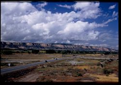
- Description:
- 50 f 6.3 Pola
- Subject:
- Grasses, Roads, Colorado National Monument (Colo.), Automobiles, Trees, Plains, Mountains, Shrubs, Traffic signs & signals, Clouds, Hills, and Mesas
- Series:
- 9-53
- Creator:
- Cushman, Charles W., 1896-1972
- Date Created:
- 1953-10-12
- Genre:
- Landscape photographs
- Frame Number:
- 23
- Street Address:
- United States Highway 50
- County:
- Mesa
- Abstract:
- View west from Grand Junction toward Colo Nat'l Mon.
- Call Number:
- P06824
- City:
- Grand Junction
- Country:
- United States
- State/Province:
- Colorado
- Physical Description:
- Image was originally mounted in a glass enclosure. Before digitization, the image was removed and placed in a Wess Plastic, Inc. brand, 2" x 2", pl...
- Alternate Identifier:
- 953.23
- Persistent URL:
- http://purl.dlib.indiana.edu/iudl/archives/cushman/P06824
-
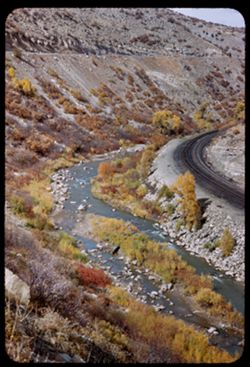
- Description:
- 50 f 8
- Subject:
- Rocks, Canyons, Grasses, Roads, Trees, Mountains, Shrubs, Price River (Utah), and Rivers
- Series:
- 9-53
- Creator:
- Cushman, Charles W., 1896-1972
- Date Created:
- 1953-10-11
- Genre:
- Views
- Frame Number:
- 22
- County:
- Carbon
- Abstract:
- Gorge of Price river near Castle Gate.
- Call Number:
- P06823
- City:
- Castle Gate
- Country:
- United States
- State/Province:
- Utah
- Alternate Identifier:
- 953.22
- Persistent URL:
- http://purl.dlib.indiana.edu/iudl/archives/cushman/P06823