
Search Constraints
You searched for:
Campus
IUB
Remove constraint Campus: IUB
Subject
Mountains
Remove constraint Subject: Mountains
Subject
Shrubs
Remove constraint Subject: Shrubs
« Previous |
1 - 100 of 1,198
|
Next »
Search Results
-
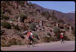
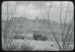
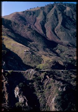
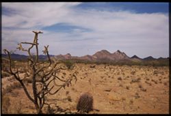
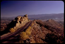
- Description:
- 100 f 11 TL
- Subject:
- Rocks, Families, Children, Valleys, Electric lines, Roads, Trees, Bicycles & tricycles, Palm Canyon (Calif.), Shrubs, and Mountains
- Series:
- 2-69
- Creator:
- Cushman, Charles W., 1896-1972
- Date Created:
- 1969-03-16
- Genre:
- Snapshots
- Frame Number:
- 29
- County:
- Riverside
- Call Number:
- P15746
- Country:
- United States
- State/Province:
- California
- Alternate Identifier:
- 269.29
- Persistent URL:
- http://purl.dlib.indiana.edu/iudl/archives/cushman/P15746
-
- Subject:
- Baboquivari Peak Wilderness (Ariz.), Trees, Mountains, and Shrubs
- Series:
- 22-40
- Creator:
- Cushman, Charles W., 1896-1972
- Date Created:
- 1940-05-01
- Genre:
- Landscape photographs
- Frame Number:
- 9
- County:
- Pima
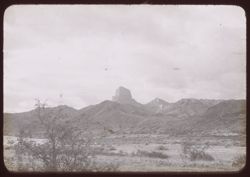
- Abstract:
- 40 - F - 9 = Baboquivari Peak nr. Ariz. - Sonora line
- Call Number:
- P01506
- Country:
- United States and Mexico
- State/Province:
- Arizona and Sonora
- Physical Description:
- black & white .
- Alternate Identifier:
- 2240.9
- Persistent URL:
- http://purl.dlib.indiana.edu/iudl/archives/cushman/P01506
-
- Subject:
- Trees, Mountains, Shrubs, and Santa Rita Mountains (Ariz.)
- Series:
- 22-40
- Creator:
- Cushman, Charles W., 1896-1972
- Date Created:
- 1940-05-01
- Genre:
- Landscape photographs
- Frame Number:
- 11
- County:
- Pima
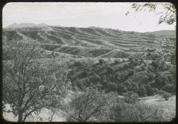
- Abstract:
- 40 - F- 11= Ariz. Ridged landscape s.e. of Tucson
- Call Number:
- P01826
- City:
- Tucson
- Country:
- United States
- State/Province:
- Arizona
- Physical Description:
- black & white .
- Alternate Identifier:
- 2240.11
- Persistent URL:
- http://purl.dlib.indiana.edu/iudl/archives/cushman/P01826
-
- Subject:
- Baboquivari Peak Wilderness (Ariz.), Mountains, and Shrubs
- Series:
- 22-40
- Creator:
- Cushman, Charles W., 1896-1972
- Date Created:
- 1940-04-01
- Genre:
- Landscape photographs
- Frame Number:
- 24
- County:
- Pima
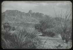
- Abstract:
- 40-F-24 = Baboquivari Peak nr. Ariz.-Sonora line
- Call Number:
- P01510
- Country:
- United States and Mexico
- State/Province:
- Arizona and Sonora
- Physical Description:
- black & white .
- Alternate Identifier:
- 2240.24
- Persistent URL:
- http://purl.dlib.indiana.edu/iudl/archives/cushman/P01510
-
- Subject:
- Baboquivari Peak Wilderness (Ariz.), Mountains, Shrubs, and Clouds
- Series:
- 22-40
- Creator:
- Cushman, Charles W., 1896-1972
- Date Created:
- 1940-05-01
- Genre:
- Landscape photographs
- Frame Number:
- 25
- County:
- Pima
- Abstract:
- 40-F-25= Baboquivari Peak nr. Ariz. - Sonora line
- Call Number:
- P01511
- Country:
- United States and Mexico
- State/Province:
- Arizona and Sonora
- Physical Description:
- black & white .
- Alternate Identifier:
- 2240.25
- Persistent URL:
- http://purl.dlib.indiana.edu/iudl/archives/cushman/P01511
-
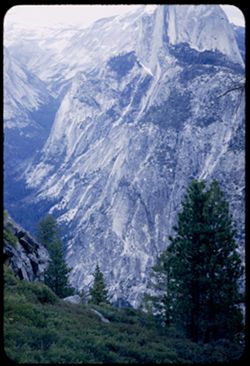
- Description:
- 25 f 4
- Subject:
- Snow, Valleys, Yosemite National Park (Calif.), Trees, Half Dome (Calif.), Mountains, National parks & reserves, Glacier Point Hotel (Mariposa County, Ca...
- Series:
- 5-53
- Creator:
- Cushman, Charles W., 1896-1972
- Date Created:
- 1953-05-13
- Genre:
- Landscape photographs
- Frame Number:
- 38
- County:
- Mariposa
- Abstract:
- Half Dome from balcony of Glacier Pt. Hotel at 6:45PM PDT [P]
- Call Number:
- P06688
- Country:
- United States
- State/Province:
- California
- Alternate Identifier:
- 553.38
- Persistent URL:
- http://purl.dlib.indiana.edu/iudl/archives/cushman/P06688
-
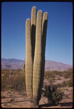
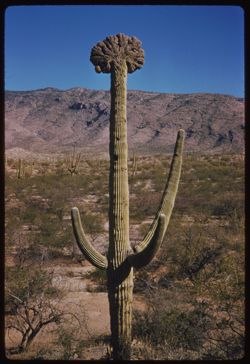
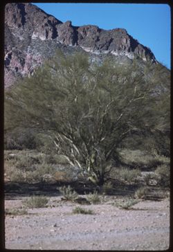
- Description:
- 50 f 11 sl
- Subject:
- Deserts, Cactus, Mountains, Shrubs, and Saguaro National Park (Ariz.)
- Series:
- 10-59
- Creator:
- Cushman, Charles W., 1896-1972
- Date Created:
- 1959-03-05
- Genre:
- Identification photographs
- Frame Number:
- 15
- County:
- Pima
- Abstract:
- A 4 in 1 Saguaro
- Call Number:
- P10703
- City:
- Tucson
- Country:
- United States
- State/Province:
- Arizona
- Alternate Identifier:
- 1059.15
- Persistent URL:
- http://purl.dlib.indiana.edu/iudl/archives/cushman/P10703
-
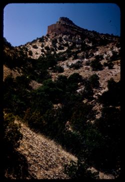
- Description:
- 25 f 8 Pola
- Subject:
- Canyons, Cliffs, Trees, Bandelier National Monument (N.M.), Mountains, Rock formations, Hills, National parks & reserves, and Shrubs
- Series:
- 18-52
- Creator:
- Cushman, Charles W., 1896-1972
- Date Created:
- 1952-04-15
- Genre:
- Landscape photographs
- Frame Number:
- 25
- Street Address:
- New Mexico State Highway 4
- Abstract:
- View up a canyon (along NM 4).
- Call Number:
- P06155
- Country:
- United States
- State/Province:
- New Mexico
- Alternate Identifier:
- 1852.25
- Persistent URL:
- http://purl.dlib.indiana.edu/iudl/archives/cushman/P06155
-
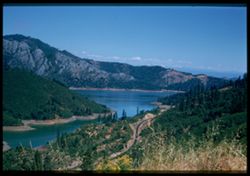
- Description:
- 100 f 5.6 50mm lens
- Subject:
- Shasta Lake (Calif.), Roads, Trees, Flowers, Mountains, Shrubs, Lakes & ponds, and Clouds
- Series:
- 17-55
- Creator:
- Cushman, Charles W., 1896-1972
- Date Created:
- 1955-06-16
- Genre:
- Landscape photographs
- Frame Number:
- 21
- County:
- Shasta
- Abstract:
- from same point
- Call Number:
- P08101
- City:
- Redding
- Country:
- United States
- State/Province:
- California
- Physical Description:
- Image was originally mounted in a glass enclosure. Before digitization, the image was removed and placed in a Wess Plastic, Inc. brand, 2" x 2", pl...
- Alternate Identifier:
- 1755.21
- Persistent URL:
- http://purl.dlib.indiana.edu/iudl/archives/cushman/P08101
-
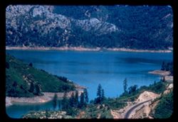
- Description:
- 100 f 6.3 tl
- Subject:
- Lakes & ponds, Roads, Mountains, Shrubs, Trees, and Shasta Lake (Calif.)
- Series:
- 17-55
- Creator:
- Cushman, Charles W., 1896-1972
- Date Created:
- 1955-06-16
- Genre:
- Landscape photographs
- Frame Number:
- 19
- County:
- Shasta
- Abstract:
- A bit of Shasta Lake 17 mi north of Redding 65636
- Call Number:
- P08099
- City:
- Redding
- Country:
- United States
- State/Province:
- California
- Alternate Identifier:
- 1755.19
- Persistent URL:
- http://purl.dlib.indiana.edu/iudl/archives/cushman/P08099
-
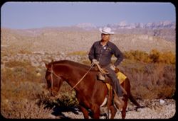
- Description:
- 50 f 6.3
- Subject:
- Horseback riding, Guards, Rio Grande, Horses, Men, Hills, Border patrols, Boquillas Canyon (Big Bend National Park (Tex.)), Cliffs, Rangers, Shrubs, Mounted ...
- Series:
- 16-51
- Creator:
- Cushman, Charles W., 1896-1972
- Date Created:
- 1951-12-27
- Genre:
- Portraits
- Frame Number:
- 18
- County:
- Brewster
- Abstract:
- Border patrol near Boquillas.
- Call Number:
- P05437
- Country:
- United States
- State/Province:
- Texas
- Alternate Identifier:
- 1651.18
- Persistent URL:
- http://purl.dlib.indiana.edu/iudl/archives/cushman/P05437
-
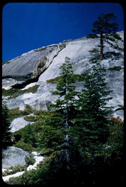
- Description:
- 50 f 9
- Subject:
- Yosemite National Park (Calif.), Trees, Pines, Mountains, Rock formations, Sentinel Dome (Calif.), National parks & reserves, and Shrubs
- Series:
- 5-53
- Creator:
- Cushman, Charles W., 1896-1972
- Date Created:
- 1953-05-13
- Frame Number:
- 12
- County:
- Mariposa
- Abstract:
- A break in the outer shell of Sentinel Dome.
- Call Number:
- P06662
- Country:
- United States
- State/Province:
- California
- Alternate Identifier:
- 553.12
- Persistent URL:
- http://purl.dlib.indiana.edu/iudl/archives/cushman/P06662
-
- Description:
- 50 f 11 sl
- Subject:
- Deserts, Cristate saguaro, Cactus, Mountains, Shrubs, and Saguaro National Park (Ariz.)
- Series:
- 10-59
- Creator:
- Cushman, Charles W., 1896-1972
- Date Created:
- 1959-03-05
- Genre:
- Identification photographs
- Frame Number:
- 9
- County:
- Pima
- Abstract:
- A fine cristate
- Call Number:
- P10697
- City:
- Tucson
- Country:
- United States
- State/Province:
- Arizona
- Alternate Identifier:
- 1059.9
- Persistent URL:
- http://purl.dlib.indiana.edu/iudl/archives/cushman/P10697
-
- Description:
- 50 f 9
- Subject:
- Wildflowers, Bays (Bodies of water), Hoover Dam (Ariz. and Nev.), Mountains, Shrubs, Lakes & ponds, Islands, Hills, and Mead, Lake (Ariz. and Nev.)
- Series:
- 16-52
- Creator:
- Cushman, Charles W., 1896-1972
- Date Created:
- 1952-04-10
- Genre:
- Landscape photographs
- Frame Number:
- 1
- County:
- Clark
- Abstract:
- Mtn top in bay of L. Mead.
- Call Number:
- P06061
- Country:
- United States
- State/Province:
- Nevada
- Physical Description:
- masked.
- Alternate Identifier:
- 1652.1
- Persistent URL:
- http://purl.dlib.indiana.edu/iudl/archives/cushman/P06061
-
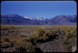
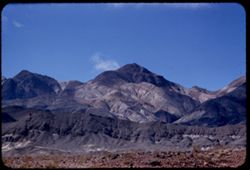
A high Sierra (prob. Owens Pk.8475 ft.) seen from Cal. 178 about ten miles N.W. of Walker Pass EK CL
- Description:
- 100 f 7 tl
- Subject:
- Snow, Roads, Owens Peak (Calif.), Trees, Walker Pass (Calif.), Signs (Notices), Mountains, Shrubs, Clouds, Vehicles, Sierra Nevada (Calif. and Nev.), Dwellin...
- Series:
- 2-55
- Creator:
- Cushman, Charles W., 1896-1972
- Date Created:
- 1955-02-26
- Genre:
- Landscape photographs
- Frame Number:
- 20
- Street Address:
- California State Highway 178
- County:
- Kern
- Abstract:
- A high Sierra* from ten miles West of Walker Pass *Lamont Pk 7468 ft. or Owens Pk 8475 ft.
- Call Number:
- P07578
- Country:
- United States
- State/Province:
- California
- Alternate Identifier:
- 255.20
- Persistent URL:
- http://purl.dlib.indiana.edu/iudl/archives/cushman/P07578
-
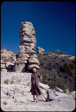
- Description:
- 50 f 9
- Subject:
- Rocks, Women, Coats, Mountains, Shrubs, Santa Catalina Mountains (Ariz.), and Rock formations
- Series:
- 4-52
- Creator:
- Cushman, Charles W., 1896-1972
- Date Created:
- 1952-01-25
- Genre:
- Landscape photographs and Portraits
- Frame Number:
- 19
- Street Address:
- Mount Lemmon Road
- Abstract:
- Jean to a chimney rock
- Call Number:
- P05625
- Country:
- United States
- State/Province:
- Arizona
- Alternate Identifier:
- 452.19
- Persistent URL:
- http://purl.dlib.indiana.edu/iudl/archives/cushman/P05625
-
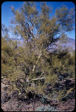
- Description:
- 25 f 11
- Subject:
- Deserts, Trees, Parkinsonia aculeata, Mountains, National parks & reserves, Saguaro National Park (Ariz.), and Shrubs
- Series:
- 3-52
- Creator:
- Cushman, Charles W., 1896-1972
- Date Created:
- 1952-01-15
- Genre:
- Identification photographs
- Frame Number:
- 8
- County:
- Pima
- Abstract:
- A Palo Verde
- Call Number:
- P05577
- City:
- Tucson
- Country:
- United States
- State/Province:
- Arizona
- Alternate Identifier:
- 352.8
- Persistent URL:
- http://purl.dlib.indiana.edu/iudl/archives/cushman/P05577
-
- Description:
- 50 f 8
- Subject:
- Hills, Davis Mountains State Park (Tex.), Shrubs, Sawtooth Mountain (Tex.), and Mountains
- Series:
- 17-51
- Creator:
- Cushman, Charles W., 1896-1972
- Date Created:
- 1951-12-29
- Genre:
- Landscape photographs
- Frame Number:
- 6
- Street Address:
- Texas State Highway 166 and Loop Texas State Highway 166
- County:
- Jeff Davis
- Abstract:
- A mtn. south of Sawtooth.
- Call Number:
- P05463
- Country:
- United States
- State/Province:
- Texas
- Alternate Identifier:
- 1751.6
- Persistent URL:
- http://purl.dlib.indiana.edu/iudl/archives/cushman/P05463
-
- Description:
- 100 f 5.6 tl
- Subject:
- Palo verde trees, Trees, Mountains, Shrubs, and Tucson Mountains (Ariz.)
- Series:
- 6-59
- Creator:
- Cushman, Charles W., 1896-1972
- Date Created:
- 1959-01-25
- Genre:
- Identification photographs
- Frame Number:
- 6
- County:
- Pima
- Abstract:
- A palo verde
- Call Number:
- P10544
- City:
- Tucson
- Country:
- United States
- State/Province:
- Arizona
- Alternate Identifier:
- 659.6
- Persistent URL:
- http://purl.dlib.indiana.edu/iudl/archives/cushman/P10544
-
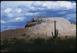
- Description:
- 100 f 8 tl
- Subject:
- Rocks, Cactus, Buttes, Mountains, Shrubs, Tucson Mountains (Ariz.), and Clouds
- Series:
- 7-59
- Creator:
- Cushman, Charles W., 1896-1972
- Date Created:
- 1959-02-02
- Genre:
- Landscape photographs
- Frame Number:
- 3
- Street Address:
- Ajo Way
- County:
- Pima
- Abstract:
- A small butte commercialized
- Call Number:
- P10579
- City:
- Tucson
- Country:
- United States
- State/Province:
- Arizona
- Alternate Identifier:
- 759.3
- Persistent URL:
- http://purl.dlib.indiana.edu/iudl/archives/cushman/P10579
-

- Subject:
- Lakes & ponds, White Mountains (N.H. and Me.), Mount Willey (N.H.), Mountains, Shrubs, and Trees
- Series:
- 16-41
- Creator:
- Cushman, Charles W., 1896-1972
- Date Created:
- 1941-09-15
- Genre:
- Landscape photographs
- Frame Number:
- 18
- Abstract:
- White Mtns., across a lake at foot of Mt. Willey
- Call Number:
- P02439
- Country:
- United States
- State/Province:
- New Hampshire
- Physical Description:
- Image was originally mounted in a glass enclosure. Before digitization, the image was removed and placed in a Wess Plastic, Inc. brand, 2" x 2", pl...
- Alternate Identifier:
- 1641.18
- Persistent URL:
- http://purl.dlib.indiana.edu/iudl/archives/cushman/P02439
-
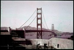
- Subject:
- Walls, Channels, Golden Gate Bridge (San Francisco, Calif.), Suspension bridges, Trees, Mountains, Fences, Shrubs, and Utility poles
- Series:
- 1-38
- Creator:
- Cushman, Charles W., 1896-1972
- Date Created:
- 1938-09-03
- Genre:
- Architectural photographs
- Frame Number:
- 5
- County:
- San Francisco
- Abstract:
- A-5 = G.G. bridge from south end.
- Call Number:
- P01411
- City:
- San Francisco
- Country:
- United States
- State/Province:
- California
- Physical Description:
- Color corrected: magenta cast [fading of yellow dye]. Image was originally mounted in a glass enclosure. Before digitization, the image was removed and place...
- Alternate Identifier:
- 138.5
- Persistent URL:
- http://purl.dlib.indiana.edu/iudl/archives/cushman/P01411
-
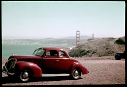
- Subject:
- Passengers, Hills, Automobiles, San Francisco Bay (Calif.), Bays (Bodies of water), Shrubs, Golden Gate Bridge (San Francisco, Calif.), Suspension bridges, C...
- Series:
- 1-38
- Creator:
- Cushman, Charles W., 1896-1972
- Date Created:
- 1938-09-03/1938-09-04
- Genre:
- Identification photographs and Views
- Frame Number:
- 9
- County:
- San Francisco
- Abstract:
- A-9= G G bridge, Bay & SF from Marin
- Call Number:
- P01413
- City:
- San Francisco
- Country:
- United States
- State/Province:
- California
- Physical Description:
- Color corrected: magenta cast [fading of yellow dye]. Image was originally mounted in a glass enclosure. Before digitization, the image was removed and place...
- Alternate Identifier:
- 138.9
- Persistent URL:
- http://purl.dlib.indiana.edu/iudl/archives/cushman/P01413
-
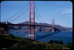
- Description:
- 50 f 8
- Subject:
- Bodies of water, Golden Gate Bridge (San Francisco, Calif.), Suspension bridges, Trees, Mountains, Shrubs, and Aircraft carriers
- Series:
- 2-53
- Creator:
- Cushman, Charles W., 1896-1972
- Date Created:
- 1953-02-12
- Genre:
- Marine photographs
- Frame Number:
- 31
- County:
- San Francisco
- Abstract:
- AC Carrier under the GG bricge.
- Call Number:
- P06565
- City:
- San Francisco
- Country:
- United States
- State/Province:
- California
- Alternate Identifier:
- 253.31
- Persistent URL:
- http://purl.dlib.indiana.edu/iudl/archives/cushman/P06565
-
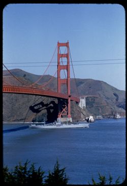
- Description:
- 100 f 5.6 tl
- Subject:
- Rocks, Bays (Bodies of water), Golden Gate Bridge (San Francisco, Calif.), Suspension bridges, Trees, Mountains, Government vessels, Shrubs, San Francisco Ba...
- Series:
- 12-55
- Creator:
- Cushman, Charles W., 1896-1972
- Date Created:
- 1955-03-30
- Genre:
- Marine photographs
- Frame Number:
- 34
- County:
- San Francisco
- Abstract:
- AG 39 George Eastman entering SF Bay passes under Golden Gate Bridge
- Call Number:
- P07930
- City:
- San Francisco
- Country:
- United States
- State/Province:
- California
- Alternate Identifier:
- 1255.34
- Persistent URL:
- http://purl.dlib.indiana.edu/iudl/archives/cushman/P07930
-
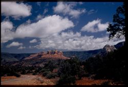
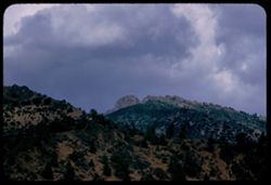
- Description:
- 50 f 6.3
- Subject:
- Hills, Mountains, Shrubs, Snow, Mingus Mountain (Ariz.), Grasses, and Rocks
- Series:
- 15-53
- Creator:
- Cushman, Charles W., 1896-1972
- Date Created:
- 1953-11-21
- Genre:
- Landscape photographs and Cityscape photographs
- Frame Number:
- 15
- County:
- Yavapai
- Abstract:
- Looking back toward Jerome and Mingus Mtn from Clarkdale
- Call Number:
- P07049
- City:
- Clarkdale and Jerome
- Country:
- United States
- State/Province:
- Arizona
- Physical Description:
- Image was originally mounted in a glass enclosure. Before digitization, the image was removed and placed in a Wess Plastic, Inc. brand, 2" x 2", pl...
- Alternate Identifier:
- 1553.15
- Persistent URL:
- http://purl.dlib.indiana.edu/iudl/archives/cushman/P07049
-
- Description:
- 25 f 13
- Subject:
- Sabino Canyon (Ariz.), Canyons, Saguaro, Cliffs, Mountains, Shrubs, Santa Catalina Mountains (Ariz.), Rock formations, and Cactus
- Series:
- 5-52
- Creator:
- Cushman, Charles W., 1896-1972
- Date Created:
- 1952-02-04
- Genre:
- Landscape photographs
- Frame Number:
- 25
- County:
- Pima
- Abstract:
- Pent house - at left - and the square castle - late
- Call Number:
- P05670
- Country:
- United States
- State/Province:
- Arizona
- Alternate Identifier:
- 552.25
- Persistent URL:
- http://purl.dlib.indiana.edu/iudl/archives/cushman/P05670
-

- Description:
- 100 f 7+ tl
- Subject:
- Snow, Trees, Mountains, Buildings, Shrubs, and Whitney, Mount (Calif.)
- Series:
- 3-55
- Creator:
- Cushman, Charles W., 1896-1972
- Date Created:
- 1955-02-27
- Genre:
- Landscape photographs
- Frame Number:
- 34
- Street Address:
- Portal Road
- County:
- Inyo
- Abstract:
- view of Whitney Road from 9 mi. up the Whitney Portal rd.
- Call Number:
- P07625
- City:
- Lone Pine
- Country:
- United States
- State/Province:
- California
- Alternate Identifier:
- 355.34
- Persistent URL:
- http://purl.dlib.indiana.edu/iudl/archives/cushman/P07625
-
- Description:
- 50 f 6.3
- Subject:
- Rocks, Yosemite Valley (Calif.), Yosemite National Park (Calif.), Mirror Lake (Mariposa County, Calif.), Mountains, National parks & reserves, Lakes &...
- Series:
- 6-53
- Creator:
- Cushman, Charles W., 1896-1972
- Date Created:
- 1953-05-14
- Genre:
- Landscape photographs
- Frame Number:
- 6
- County:
- Mariposa
- Abstract:
- Across Mirror Lake
- Call Number:
- P06694
- Country:
- United States
- State/Province:
- California
- Alternate Identifier:
- 653.6
- Persistent URL:
- http://purl.dlib.indiana.edu/iudl/archives/cushman/P06694
-
- Description:
- 25 f 8 Pola
- Subject:
- Rocks, Inyo Mountains (Calif.), Boulders, Owens Valley (Calif.), Mountains, Shrubs, Hills, and Snow
- Series:
- 14-52
- Creator:
- Cushman, Charles W., 1896-1972
- Date Created:
- 1952-04-08
- Genre:
- Landscape photographs
- Frame Number:
- 32
- Street Address:
- Mount Whitney Road
- County:
- Inyo
- Abstract:
- Across Owens Valley to Inyo Mtns.
- Call Number:
- P06015
- City:
- Lone Pine
- Country:
- United States
- State/Province:
- California
- Alternate Identifier:
- 1452.32
- Persistent URL:
- http://purl.dlib.indiana.edu/iudl/archives/cushman/P06015
-
- Description:
- 50 f 6.3
- Subject:
- Canyons, Roads, Trees, Salmon Creek Canyon (Mendocino County, Calif.), Shrubs, Pacific Coast Highway, Cliffs, Salmon Creek (Mendocino County, Calif.), Mounta...
- Series:
- 9-52
- Creator:
- Cushman, Charles W., 1896-1972
- Date Created:
- 1952-01-01
- Genre:
- Landscape photographs
- Frame Number:
- 14
- Street Address:
- California State Highway 1
- County:
- San Luis Obispo and Monterey
- Abstract:
- Across a green clad canyon. The road winds at Salmon Creek
- Call Number:
- P05812
- City:
- Big Sur and San Simeon
- Country:
- United States
- State/Province:
- California
- Physical Description:
- Image was originally mounted in a glass enclosure. Before digitization, the image was removed and placed in a Wess Plastic, Inc. brand, 2" x 2", pl...
- Alternate Identifier:
- 952.14
- Persistent URL:
- http://purl.dlib.indiana.edu/iudl/archives/cushman/P05812
-
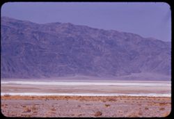
- Description:
- 100 f 8 tl
- Subject:
- Park headquarters, Valleys, Fog, Mountains, Shrubs, and Panamint Range (Calif.)
- Series:
- 11-55
- Creator:
- Cushman, Charles W., 1896-1972
- Date Created:
- 1955-03-23
- Genre:
- Landscape photographs
- Frame Number:
- 14
- County:
- Inyo
- Abstract:
- Valley floor from near Park Hqtrs
- Call Number:
- P07876
- Country:
- United States
- State/Province:
- California
- Alternate Identifier:
- 1155.14
- Persistent URL:
- http://purl.dlib.indiana.edu/iudl/archives/cushman/P07876
-
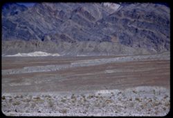
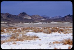
- Description:
- 200 f 5
- Subject:
- Deserts, Funeral Mountains (Calif.), Mountains, Shrubs, Death Valley (Calif. and Nev.), and Rocks
- Series:
- 3-55
- Creator:
- Cushman, Charles W., 1896-1972
- Date Created:
- 1955-02-27
- Genre:
- Landscape photographs
- Frame Number:
- 11
- Abstract:
- Funeral Mtns closer
- Call Number:
- P07603
- Country:
- United States
- State/Province:
- California
- Alternate Identifier:
- 355.11
- Persistent URL:
- http://purl.dlib.indiana.edu/iudl/archives/cushman/P07603
-
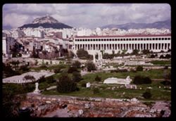
- Description:
- 100 f 11
- Subject:
- Agora (Athens, Greece), Archaeological sites, Stoa of Attalos (Athens, Greece), Conservation & restoration, Cities & towns, Buildings, Shrubs, Clouds...
- Series:
- 9-65
- Creator:
- Cushman, Charles W., 1896-1972
- Date Created:
- 1965-04-13
- Genre:
- Cityscape photographs
- Frame Number:
- 26
- County:
- Attica
- Abstract:
- Across Agora toward Likavitos
- Call Number:
- P14154
- City:
- Athens
- Country:
- Greece
- State/Province:
- Central Greece and Euboea
- Alternate Identifier:
- 965.26
- Persistent URL:
- http://purl.dlib.indiana.edu/iudl/archives/cushman/P14154
-
- Description:
- 50 f 11
- Subject:
- Sawtooth Ridge (Calif.), Twin Peaks (San Francisco County, Calif.), Dirt roads, Flowers, Matterhorn Peak (Calif.), Mountains, Shrubs, Sierra Nevada (Calif. a...
- Series:
- 9-54
- Creator:
- Cushman, Charles W., 1896-1972
- Date Created:
- 1954-09-16
- Genre:
- Landscape photographs
- Frame Number:
- 17
- Street Address:
- United States Highway 395
- County:
- Mono
- Abstract:
- Matterhorn and Twin Peaks from Hwy 395 to NE (?). Mountains of Sawtooth Ridge, all over, 11,000 ft.
- Call Number:
- P07328
- City:
- Bridgeport
- Country:
- United States
- State/Province:
- California
- Alternate Identifier:
- 954.17
- Persistent URL:
- http://purl.dlib.indiana.edu/iudl/archives/cushman/P07328
-
- Subject:
- Mountains, Dirt roads, Dwellings, Trees, Clouds, Wildflowers, Fences, and Shrubs
- Series:
- 13-40
- Creator:
- Cushman, Charles W., 1896-1972
- Date Created:
- 1940-07-18
- Genre:
- Landscape photographs
- Frame Number:
- 17
- County:
- Santa Fe and San Miguel
- Abstract:
- An adobe village off the Santa Fe- Las Vegas highway. Thursday forenoon
- Call Number:
- P02017
- City:
- Las Vegas and Santa Fe
- Country:
- United States
- State/Province:
- New Mexico
- Physical Description:
- Image was originally mounted in a glass enclosure. Before digitization, the image was removed and placed in a Wess Plastic, Inc. brand, 2" x 2", pl...
- Alternate Identifier:
- 1340.17
- Persistent URL:
- http://purl.dlib.indiana.edu/iudl/archives/cushman/P02017
-
- Subject:
- Dirt roads, Adobe buildings, Trees, Shadows, Mountains, Shrubs, Clouds, and Dwellings
- Series:
- 13-40
- Creator:
- Cushman, Charles W., 1896-1972
- Date Created:
- 1940-07-18
- Genre:
- Landscape photographs
- Frame Number:
- 17
- County:
- Santa Fe and San Miguel
- Abstract:
- An adobe village off the Santa Fe- Las Vegas highway. Thursday forenoon
- Call Number:
- P01817
- City:
- Santa Fe and Las Vegas
- Country:
- United States
- State/Province:
- New Mexico
- Physical Description:
- masked. Image was originally mounted in a glass enclosure. Before digitization, the image was removed and placed in a Wess Plastic, Inc. brand, 2" x 2&q...
- Alternate Identifier:
- 1340.17
- Persistent URL:
- http://purl.dlib.indiana.edu/iudl/archives/cushman/P01817
-
- Description:
- 25 f 6 Pola
- Subject:
- Hills, Fog, Pacific Ocean, Mountains, Pacific Coast (Calif.), Shrubs, Trees, and Grasses
- Series:
- 12-52
- Creator:
- Cushman, Charles W., 1896-1972
- Date Created:
- 1952-03-28
- Genre:
- Landscape photographs
- Frame Number:
- 13
- Street Address:
- Skyline Drive
- County:
- San Francisco and San Mateo
- Abstract:
- Fog bank moving in across mtns. South of S.F. = view is NW from Skyline Dr. above San Mateo.
- Call Number:
- P05920
- City:
- San Francisco and San Mateo
- Country:
- United States
- State/Province:
- California
- Alternate Identifier:
- 1252.13
- Persistent URL:
- http://purl.dlib.indiana.edu/iudl/archives/cushman/P05920
-
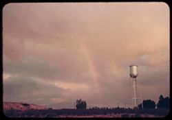
- Subject:
- Rainbows, Electric lines, Rincon Mountains (Ariz.), Trees, Mountains, Shrubs, Bridges, Utility poles, Water towers, and Clouds
- Series:
- 1-40
- Creator:
- Cushman, Charles W., 1896-1972
- Date Created:
- 1940-02-01
- Genre:
- Landscape photographs and Snapshots
- Frame Number:
- 10
- County:
- Pima
- Abstract:
- Afternoon rainbow over Rincon Mtns.
- Call Number:
- P01747
- City:
- Tucson
- Country:
- United States
- State/Province:
- Arizona
- Alternate Identifier:
- 140.10
- Persistent URL:
- http://purl.dlib.indiana.edu/iudl/archives/cushman/P01747
-
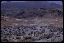
- Description:
- 100 f 8 + tl
- Subject:
- Valleys, Greenwater Range (Calif.), Minerals, Alkali, Mountains, Shrubs, and Hills
- Series:
- 12-55
- Creator:
- Cushman, Charles W., 1896-1972
- Date Created:
- 1955-03-24
- Genre:
- Landscape photographs
- Frame Number:
- 4
- County:
- Inyo
- Abstract:
- Alkali beds south of Shoshone
- Call Number:
- P07900
- City:
- Shoshone
- Country:
- United States
- State/Province:
- California
- Alternate Identifier:
- 1255.4
- Persistent URL:
- http://purl.dlib.indiana.edu/iudl/archives/cushman/P07900
-
- Description:
- 25 f 9
- Subject:
- Lost Mine Trail (Big Bend National Park (Tex.)), Tree limbs, Big Bend National Park (Tex.), Mountains, Shrubs, Trees, Trails & paths, Junipers, and Natio...
- Series:
- 16-51
- Creator:
- Cushman, Charles W., 1896-1972
- Date Created:
- 1951-12-28
- Genre:
- Identification photographs
- Frame Number:
- 20
- County:
- Brewster
- Abstract:
- Alligator Juniper
- Call Number:
- P05439
- Country:
- United States
- State/Province:
- Texas
- Alternate Identifier:
- 1651.20
- Persistent URL:
- http://purl.dlib.indiana.edu/iudl/archives/cushman/P05439
-
- Description:
- 25 f 10
- Subject:
- Rocks, Grasses, Trees, Boulders, Mountains, Shrubs, and Hills
- Series:
- 12-52
- Creator:
- Cushman, Charles W., 1896-1972
- Date Created:
- 1952-04-03
- Genre:
- Landscape photographs
- Frame Number:
- 35
- Street Address:
- California State Highway 49
- County:
- El Dorado and Placer
- Abstract:
- Rocks + brown shrubs on green mtn. Side = Auburn - Placerville Hwy 49.
- Call Number:
- P05941
- City:
- Placerville and Auburn
- Country:
- United States
- State/Province:
- California
- Alternate Identifier:
- 1252.35
- Persistent URL:
- http://purl.dlib.indiana.edu/iudl/archives/cushman/P05941
-
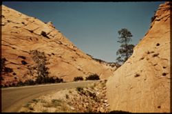
- Subject:
- Rocks, Roads, Trees, Mountains, Shrubs, Zion National Park (Utah), and National parks & reserves
- Series:
- 11-40
- Creator:
- Cushman, Charles W., 1896-1972
- Date Created:
- 1940-07-11
- Genre:
- Landscape photographs
- Frame Number:
- 14
- Street Address:
- Mt. Carmel Road
- County:
- Washington
- Abstract:
- Mt. Carmel Road - east of Zion tunnel.
- Call Number:
- P01973
- Country:
- United States
- State/Province:
- Utah
- Physical Description:
- Image was originally mounted in a glass enclosure. Before digitization, the image was removed and placed in a Wess Plastic, Inc. brand, 2" x 2", pl...
- Alternate Identifier:
- 1140.14
- Persistent URL:
- http://purl.dlib.indiana.edu/iudl/archives/cushman/P01973
-
- Description:
- 25 f 9 Pola
- Subject:
- Canyons, Roads, Barbed wire, Trees, Tree limbs, Mountains, Fences, Shrubs, Clouds, Oak Creek Canyon (Ariz.), and Rock formations
- Series:
- 16-52
- Creator:
- Cushman, Charles W., 1896-1972
- Date Created:
- 1952-04-12
- Genre:
- Landscape photographs
- Frame Number:
- 33
- Street Address:
- United States Highway 89A
- County:
- Coconino
- Call Number:
- P06091
- City:
- Flagstaff
- Country:
- United States
- State/Province:
- Arizona
- Physical Description:
- Image was originally mounted in a glass enclosure. Before digitization, the image was removed and placed in a Wess Plastic, Inc. brand, 2" x 2", pl...
- Alternate Identifier:
- 1652.33
- Persistent URL:
- http://purl.dlib.indiana.edu/iudl/archives/cushman/P06091
-
- Description:
- 50 f 11
- Subject:
- Rocks, Grasses, Shadows, Rock slopes, Tree limbs, Mountains, and Shrubs
- Series:
- 8-53
- Creator:
- Cushman, Charles W., 1896-1972
- Date Created:
- 1953-10-09
- Frame Number:
- 34
- Street Address:
- United States Highway 50
- County:
- Carson City
- Abstract:
- Rock + rock.
- Call Number:
- P06796
- City:
- Carson City
- Country:
- United States
- State/Province:
- Nevada
- Alternate Identifier:
- 853.34
- Persistent URL:
- http://purl.dlib.indiana.edu/iudl/archives/cushman/P06796
-
- Description:
- 50 f 9
- Subject:
- Rocks, Trees, Pines, Dirt, Tree limbs, Mountains, Shrubs, and Sierra Nevada (Calif. and Nev.)
- Series:
- 8-53
- Creator:
- Cushman, Charles W., 1896-1972
- Date Created:
- 1953-10-09
- Genre:
- Landscape photographs
- Frame Number:
- 14
- Street Address:
- United States Highway 50
- County:
- El Dorado
- Abstract:
- Along US 50 between Kyburz + Phillips.
- Call Number:
- P06776
- City:
- Kyburz, Phillips, and Little Norway
- Country:
- United States
- State/Province:
- California
- Alternate Identifier:
- 853.14
- Persistent URL:
- http://purl.dlib.indiana.edu/iudl/archives/cushman/P06776
-
- Description:
- 50 f 7
- Subject:
- Rocks, Trees, Pines, Mountains, Shrubs, and Sierra Nevada (Calif. and Nev.)
- Series:
- 8-53
- Creator:
- Cushman, Charles W., 1896-1972
- Date Created:
- 1953-10-09
- Genre:
- Landscape photographs
- Frame Number:
- 15
- Street Address:
- United States Highway 50
- County:
- El Dorado
- Abstract:
- Back to left from Along US 50 between Kyburz + Phillips. shot high on left bank of Hwy.
- Call Number:
- P06777
- City:
- Kyburz, Phillips, and Little Norway
- Country:
- United States
- State/Province:
- California
- Alternate Identifier:
- 853.15
- Persistent URL:
- http://purl.dlib.indiana.edu/iudl/archives/cushman/P06777
-
- Subject:
- Tree limbs, Mountains, Shrubs, Sierra Nevada (Calif. and Nev.), Trees, Rocks, and Pines
- Series:
- 8-53
- Creator:
- Cushman, Charles W., 1896-1972
- Date Created:
- 1953-01-01
- Genre:
- Landscape photographs
- Frame Number:
- 13
- Street Address:
- United States Highway 50
- County:
- El Dorado
- Abstract:
- Along US 50 between Kyburz + Phillips.
- Call Number:
- P06775
- City:
- Kyburz, Phillips, and Little Norway
- Country:
- United States
- State/Province:
- California
- Alternate Identifier:
- 853.13
- Persistent URL:
- http://purl.dlib.indiana.edu/iudl/archives/cushman/P06775
-
- Description:
- 25 f 9
- Subject:
- Hills, Barbed wire, Cliffs, Mountains, Shrubs, Trees, Rock formations, Fences, and Boulders
- Series:
- 27-52
- Creator:
- Cushman, Charles W., 1896-1972
- Date Created:
- 1952-11-05
- Genre:
- Landscape photographs
- Frame Number:
- 35
- Street Address:
- United States Highway 50
- County:
- Utah
- Abstract:
- Odd rock formation - east of Thistle.
- Call Number:
- P06480
- City:
- Thistle
- Country:
- United States
- State/Province:
- Utah
- Alternate Identifier:
- 2752.35
- Persistent URL:
- http://purl.dlib.indiana.edu/iudl/archives/cushman/P06480
-
- Description:
- 25 f 9
- Subject:
- Rocks, Electric lines, Cliffs, Boulders, Mountains, Rock formations, Hills, and Shrubs
- Series:
- 27-52
- Creator:
- Cushman, Charles W., 1896-1972
- Date Created:
- 1952-11-05
- Genre:
- Snapshots and Identification photographs
- Frame Number:
- 34
- Street Address:
- United States Highway 50
- County:
- Utah
- Abstract:
- Odd rock formation Utah Co. Utah.
- Call Number:
- P06479
- Country:
- United States
- State/Province:
- Utah
- Alternate Identifier:
- 2752.34
- Persistent URL:
- http://purl.dlib.indiana.edu/iudl/archives/cushman/P06479
-
- Description:
- 25 f 11
- Subject:
- Rocks, Cliffs, Trees, Mountains, Rock formations, Arches National Park (Utah), Hills, and Shrubs
- Series:
- 27-52
- Creator:
- Cushman, Charles W., 1896-1972
- Date Created:
- 1952-11-04
- Genre:
- Landscape photographs
- Frame Number:
- 8
- County:
- Grand
- Abstract:
- Along Hwy from Moab to Arches.
- Call Number:
- P06453
- City:
- Moab
- Country:
- United States
- State/Province:
- Utah
- Alternate Identifier:
- 2752.8
- Persistent URL:
- http://purl.dlib.indiana.edu/iudl/archives/cushman/P06453
-
- Description:
- 25 f 13
- Subject:
- Deserts, Mojave Desert (Calif.), Walker Pass (Calif.), Joshua trees, Mountains, Shrubs, and Hills
- Series:
- 12-54
- Creator:
- Cushman, Charles W., 1896-1972
- Date Created:
- 1954-09-18
- Genre:
- Identification photographs
- Frame Number:
- 30
- Street Address:
- California State Highway 178 and Walker Pass Road
- County:
- Kern
- Abstract:
- Joshua trees along Walker Pass Rd.
- Call Number:
- P07420
- Country:
- United States
- State/Province:
- California
- Alternate Identifier:
- 1254.30
- Persistent URL:
- http://purl.dlib.indiana.edu/iudl/archives/cushman/P07420
-
- Description:
- 200 f 4.5 tl
- Subject:
- Rocks, Dantes View (Calif.), Mountains, Shrubs, Death Valley (Calif. and Nev.), Rock formations, and Furnace Creek Inn (Death Valley Junction, Calif.)
- Series:
- 2-55
- Creator:
- Cushman, Charles W., 1896-1972
- Date Created:
- 1955-02-27
- Genre:
- Landscape photographs
- Frame Number:
- 26
- County:
- Inyo
- Abstract:
- Elephant hide 10 miles SE of Furnace Ck. Inn
- Call Number:
- P07584
- City:
- Death Valley Junction
- Country:
- United States
- State/Province:
- California
- Alternate Identifier:
- 255.26
- Persistent URL:
- http://purl.dlib.indiana.edu/iudl/archives/cushman/P07584
-
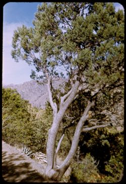
- Description:
- 100 f 11
- Subject:
- Valleys, Rocks, Trails & paths, Fences, Hills, Mountains, Trees, Alps, Austrian (Austria), Shrubs, Forests, and Stubay Valley (Austria)
- Series:
- 17-64
- Creator:
- Cushman, Charles W., 1896-1972
- Date Created:
- 1964-06-09
- Genre:
- Landscape photographs
- Frame Number:
- 26
- Abstract:
- from height to height
- Call Number:
- P13567
- City:
- Neustift
- Country:
- Austria
- State/Province:
- Tyrol
- Alternate Identifier:
- 1764.26
- Persistent URL:
- http://purl.dlib.indiana.edu/iudl/archives/cushman/P13567
-
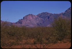
- Subject:
- Deserts, Roskruge Mountains (Ariz.), Mountains, Shrubs, Cactus, and Clouds
- Series:
- 5-40
- Creator:
- Cushman, Charles W., 1896-1972
- Date Created:
- 1940-05-01
- Genre:
- Landscape photographs
- Frame Number:
- 17
- County:
- Pima
- Abstract:
- An Arizona desert . Roskruge Mtns. In distance. View is northeast.
- Call Number:
- P01835
- Country:
- United States
- State/Province:
- Arizona
- Physical Description:
- Image was originally mounted in a glass enclosure. Before digitization, the image was removed and placed in a Wess Plastic, Inc. brand, 2" x 2", pl...
- Alternate Identifier:
- 540.17
- Persistent URL:
- http://purl.dlib.indiana.edu/iudl/archives/cushman/P01835
-
- Description:
- 100 f 6.3 tl
- Subject:
- Siskiyou Mountains (Calif. and Or.), Mountains, Shrubs, Trees, Rock formations, and Clouds
- Series:
- 10-56
- Creator:
- Cushman, Charles W., 1896-1972
- Date Created:
- 1956-07-13
- Genre:
- Landscape photographs
- Frame Number:
- 24
- Street Address:
- United States Highway 99
- County:
- Siskiyou
- Abstract:
- A very high perch - Siskiyou Mtns. north of Yreka
- Call Number:
- P08884
- City:
- Yreka
- Country:
- United States
- State/Province:
- California
- Alternate Identifier:
- 1056.24
- Persistent URL:
- http://purl.dlib.indiana.edu/iudl/archives/cushman/P08884
-
- Subject:
- East Bay Hills (Calif.), Vessels, Islands, Mountains, Angel Island (Calif.), Trees, Dwellings, Bays (Bodies of water), San Francisco Bay (Calif.), Streets, A...
- Series:
- 8-40
- Creator:
- Cushman, Charles W., 1896-1972
- Date Created:
- 1940-07-01
- Genre:
- Views
- Frame Number:
- 17
- County:
- Marin and San Francisco
- Abstract:
- Sausolito, Angel Island, and East Bay Hills.
- Call Number:
- P01900
- City:
- San Francisco and Sausalito
- Country:
- United States
- State/Province:
- California
- Physical Description:
- Image was originally mounted in a glass enclosure. Before digitization, the image was removed and placed in a Wess Plastic, Inc. brand, 2" x 2", pl...
- Alternate Identifier:
- 840.17
- Persistent URL:
- http://purl.dlib.indiana.edu/iudl/archives/cushman/P01900
-

- Description:
- 100 f 13
- Subject:
- Rocks, Grasses, Roads, Mountains, Shrubs, Bridges, Animas River (Colo. and N.M.), and Rivers
- Series:
- 34-65
- Creator:
- Cushman, Charles W., 1896-1972
- Date Created:
- 1965-10-03
- Genre:
- Landscape photographs
- Frame Number:
- 12
- County:
- La Plata
- Abstract:
- Animas river below Durango
- Call Number:
- P15004
- City:
- Durango
- Country:
- United States
- State/Province:
- Colorado
- Alternate Identifier:
- 3465.12
- Persistent URL:
- http://purl.dlib.indiana.edu/iudl/archives/cushman/P15004
-
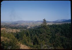
- Description:
- 50 f 8
- Subject:
- Villages, Trees, Mountains, Buildings, Shrubs, and Dwellings
- Series:
- 7-54
- Creator:
- Cushman, Charles W., 1896-1972
- Date Created:
- 1954-08-21
- Genre:
- Cityscape photographs
- Frame Number:
- 12
- County:
- Lassen
- Abstract:
- Susanville below.
- Call Number:
- P07267
- City:
- Susanville
- Country:
- United States
- State/Province:
- California
- Alternate Identifier:
- 754.12
- Persistent URL:
- http://purl.dlib.indiana.edu/iudl/archives/cushman/P07267
-
- Description:
- 25 f 11
- Subject:
- National parks & reserves, La Sal Mountains (Utah), Cliffs, Mountains, Dirt roads, Shrubs, Trees, Buttes, Rock formations, and Arches National Park (Utah)
- Series:
- 26-52
- Creator:
- Cushman, Charles W., 1896-1972
- Date Created:
- 1952-11-03
- Genre:
- Landscape photographs
- Frame Number:
- 22
- County:
- Grand
- Abstract:
- Entering Nat'l Mon.
- Call Number:
- P06428
- City:
- Moab
- Country:
- United States
- State/Province:
- Utah
- Alternate Identifier:
- 2652.22
- Persistent URL:
- http://purl.dlib.indiana.edu/iudl/archives/cushman/P06428
-
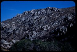
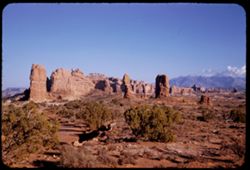
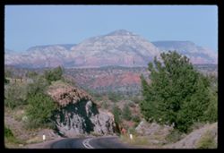
- Description:
- 100 f 11
- Subject:
- Hills, Roads, Cliffs, Mountains, Shrubs, Trees, and Grasses
- Series:
- 5-62
- Creator:
- Cushman, Charles W., 1896-1972
- Date Created:
- 1962-10-05
- Genre:
- Landscape photographs
- Frame Number:
- 16
- County:
- Coconino
- Abstract:
- East from 6 or 7 mi. west of Sedona
- Call Number:
- P12783
- City:
- Sedona
- Country:
- United States
- State/Province:
- Arizona
- Alternate Identifier:
- 562.16
- Persistent URL:
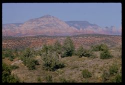
- http://purl.dlib.indiana.edu/iudl/archives/cushman/P12783
-
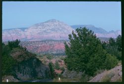
- Description:
- 100 f 13 ?
- Subject:
- Cliffs, Cactus, Trees, Mountains, Shrubs, and Hills
- Series:
- 5-62
- Creator:
- Cushman, Charles W., 1896-1972
- Date Created:
- 1962-10-05
- Genre:
- Landscape photographs
- Frame Number:
- 15
- County:
- Coconino
- Abstract:
- East from 6 or 7 mi west of Sedona
- Call Number:
- P12782
- City:
- Sedona
- Country:
- United States
- State/Province:
- Arizona
- Alternate Identifier:
- 562.15
- Persistent URL:
- http://purl.dlib.indiana.edu/iudl/archives/cushman/P12782
-
- Description:
- 50 f 6.3 POLA
- Subject:
- Grasses, Cliffs, Mesas, Mountains, Fences, Shrubs, Clouds, Hills, and Trees
- Series:
- 15-53
- Creator:
- Cushman, Charles W., 1896-1972
- Date Created:
- 1953-11-21
- Genre:
- Landscape photographs
- Frame Number:
- 18
- Street Address:
- United States Highway 89A
- County:
- Coconino
- Abstract:
- View North
- Call Number:
- P07051
- City:
- Sedona
- Country:
- United States
- State/Province:
- Arizona
- Alternate Identifier:
- 1553.18
- Persistent URL:
- http://purl.dlib.indiana.edu/iudl/archives/cushman/P07051
-
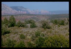
- Description:
- 100 f 13 ?
- Subject:
- Cliffs, Cactus, Trees, Mountains, Shrubs, and Hills
- Series:
- 5-62
- Creator:
- Cushman, Charles W., 1896-1972
- Date Created:
- 1962-10-05
- Genre:
- Landscape photographs
- Frame Number:
- 14
- County:
- Coconino
- Abstract:
- East from 6 or 7 mi west of Sedona
- Call Number:
- P12781
- City:
- Sedona
- Country:
- United States
- State/Province:
- Arizona
- Alternate Identifier:
- 562.14
- Persistent URL:
- http://purl.dlib.indiana.edu/iudl/archives/cushman/P12781
-
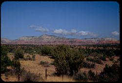
- Description:
- 100 f 9
- Subject:
- Hills, Roads, Cliffs, Mountains, Shrubs, Trees, and Grasses
- Series:
- 5-62
- Creator:
- Cushman, Charles W., 1896-1972
- Date Created:
- 1962-10-05
- Genre:
- Landscape photographs
- Frame Number:
- 17
- County:
- Coconino
- Abstract:
- East from 6 or 7 mi. west of Sedona
- Call Number:
- P12784
- City:
- Sedona
- Country:
- United States
- State/Province:
- Arizona
- Alternate Identifier:
- 562.17
- Persistent URL:
- http://purl.dlib.indiana.edu/iudl/archives/cushman/P12784
-
- Subject:
- Cliffs, Weeping Rock (Utah), Trees, Mountains, Shrubs, Zion National Park (Utah), Temple of Sinawava (Utah), Zion Canyon (Utah), and National parks & res...
- Series:
- 11-40
- Creator:
- Cushman, Charles W., 1896-1972
- Date Created:
- 1940-07-11
- Genre:
- Landscape photographs
- Frame Number:
- 0
- County:
- Washington
- Abstract:
- At Zion canyon. From trail to Weeping Rock.
- Call Number:
- P01961
- Country:
- United States
- State/Province:
- Utah
- Physical Description:
- masked. Image was originally mounted in a glass enclosure. Before digitization, the image was removed and placed in a Wess Plastic, Inc. brand, 2" x 2&q...
- Alternate Identifier:
- 1140.0
- Persistent URL:
- http://purl.dlib.indiana.edu/iudl/archives/cushman/P01961
-
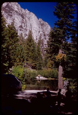
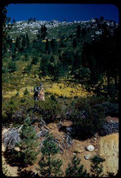
- Description:
- 50 f 9
- Subject:
- Bodies of water, Trees, Boulders, Shadows, Mountains, Shrubs, Lakes & ponds, Whitney, Mount (Calif.), People, and Reflections
- Series:
- 12-54
- Creator:
- Cushman, Charles W., 1896-1972
- Date Created:
- 1954-09-18
- Genre:
- Landscape photographs
- Frame Number:
- 22
- Street Address:
- Mt. Whitney Road
- County:
- Inyo
- Abstract:
- Vacationers at Mt Whitney Portal campground.
- Call Number:
- P07412
- Country:
- United States
- State/Province:
- California
- Alternate Identifier:
- 1254.22
- Persistent URL:
- http://purl.dlib.indiana.edu/iudl/archives/cushman/P07412
-
- Description:
- 25 f 6.3 Pola
- Subject:
- Roads, Mountains, Shrubs, Trees, Rocks, Rock formations, Boulders, and Buildings
- Series:
- 23-52
- Creator:
- Cushman, Charles W., 1896-1972
- Date Created:
- 1952-10-28
- Genre:
- Landscape photographs
- Frame Number:
- 22
- Street Address:
- Skyline Drive
- County:
- Fremont
- Abstract:
- Atop the comb of Skyline Dr.
- Call Number:
- P06314
- City:
- Canon City
- Country:
- United States
- State/Province:
- Colorado
- Alternate Identifier:
- 2352.22
- Persistent URL:
- http://purl.dlib.indiana.edu/iudl/archives/cushman/P06314
-
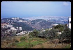
- Description:
- 100 f 13
- Subject:
- Trees, Cities & towns, Buildings, Shrubs, Hills, and Mountains
- Series:
- 16-65
- Creator:
- Cushman, Charles W., 1896-1972
- Date Created:
- 1965-05-03
- Genre:
- Cityscape photographs
- Frame Number:
- 31
- Abstract:
- Beirut from height at S.E.
- Call Number:
- P14420
- City:
- Beirut
- Country:
- Lebanon
- State/Province:
- Beirut
- Alternate Identifier:
- 1665.31
- Persistent URL:
- http://purl.dlib.indiana.edu/iudl/archives/cushman/P14420
-
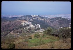
- Subject:
- Trees, Mountains, Buildings, Shrubs, Hills, and Cities & towns
- Series:
- 16-65
- Creator:
- Cushman, Charles W., 1896-1972
- Date Created:
- 1965-05-03
- Genre:
- Cityscape photographs
- Frame Number:
- 30
- Abstract:
- Beirut from height at S.E.
- Call Number:
- P14419
- City:
- Beirut
- Country:
- Lebanon
- State/Province:
- Beirut
- Alternate Identifier:
- 1665.30
- Persistent URL:
- http://purl.dlib.indiana.edu/iudl/archives/cushman/P14419
-
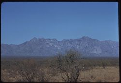
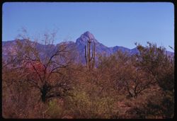
- Description:
- 100 f 9 tl
- Subject:
- Baboquivari Mountains (Ariz.), Baboquivari Peak (Ariz.), Mountains, and Shrubs
- Series:
- 9-59
- Creator:
- Cushman, Charles W., 1896-1972
- Date Created:
- 1959-02-20
- Genre:
- Landscape photographs
- Frame Number:
- 2
- County:
- Pima
- Abstract:
- His neighbor to north
- Call Number:
- P10653
- Country:
- United States
- State/Province:
- Arizona
- Alternate Identifier:
- 959.2
- Persistent URL:
- http://purl.dlib.indiana.edu/iudl/archives/cushman/P10653
-
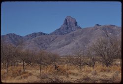
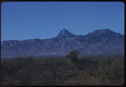
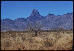
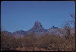
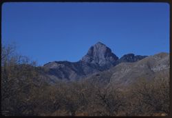
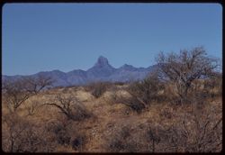
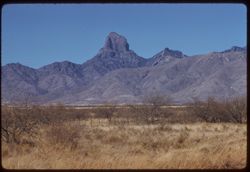
- Description:
- 100 f 9 tl
- Subject:
- Baboquivari Peak (Ariz.), Mountains, Shrubs, and Grasses
- Series:
- 6-59
- Creator:
- Cushman, Charles W., 1896-1972
- Date Created:
- 1959-01-28
- Genre:
- Landscape photographs
- Frame Number:
- 17
- County:
- Pima
- Abstract:
- Broadside view of Babo. range further north of PK.
- Call Number:
- P10555
- Country:
- United States
- State/Province:
- Arizona
- Alternate Identifier:
- 659.17
- Persistent URL:
- http://purl.dlib.indiana.edu/iudl/archives/cushman/P10555
-
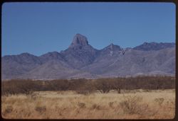
- Description:
- 100 f 8 tl
- Subject:
- Baboquivari Peak (Ariz.), Mountains, Fences, and Shrubs
- Series:
- 6-59
- Creator:
- Cushman, Charles W., 1896-1972
- Date Created:
- 1959-01-28
- Genre:
- Landscape photographs
- Frame Number:
- 27
- County:
- Pima
- Abstract:
- Babo
- Call Number:
- P10565
- Country:
- United States
- State/Province:
- Arizona
- Alternate Identifier:
- 659.27
- Persistent URL:
- http://purl.dlib.indiana.edu/iudl/archives/cushman/P10565
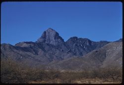
-
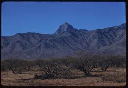
- Description:
- 100 f 9 tl
- Subject:
- Baboquivari Peak (Ariz.), Mountains, and Shrubs
- Series:
- 6-59
- Creator:
- Cushman, Charles W., 1896-1972
- Date Created:
- 1959-01-28
- Genre:
- Landscape photographs
- Frame Number:
- 31
- County:
- Pima
- Abstract:
- Babo head & shoulders
- Call Number:
- P10569
- Country:
- United States
- State/Province:
- Arizona
- Alternate Identifier:
- 659.31
- Persistent URL:
- http://purl.dlib.indiana.edu/iudl/archives/cushman/P10569
-
- Description:
- 100 f 8 tl
- Subject:
- Baboquivari Peak (Ariz.), Mountains, and Shrubs
- Series:
- 6-59
- Creator:
- Cushman, Charles W., 1896-1972
- Date Created:
- 1959-01-28
- Genre:
- Landscape photographs
- Frame Number:
- 20
- County:
- Pima
- Abstract:
- Baboquivari
- Call Number:
- P10558
- Country:
- United States
- State/Province:
- Arizona
- Alternate Identifier:
- 659.20
- Persistent URL:
- http://purl.dlib.indiana.edu/iudl/archives/cushman/P10558
-
- Description:
- 100 f 8 tl
- Subject:
- Baboquivari Peak (Ariz.), Mountains, and Shrubs
- Series:
- 6-59
- Creator:
- Cushman, Charles W., 1896-1972
- Date Created:
- 1959-01-28
- Genre:
- Landscape photographs
- Frame Number:
- 16
- County:
- Pima
- Abstract:
- Baboquivari from the east, from farther south (7864' elev)
- Call Number:
- P10554
- Country:
- United States
- State/Province:
- Arizona
- Alternate Identifier:
- 659.16
- Persistent URL:
- http://purl.dlib.indiana.edu/iudl/archives/cushman/P10554
-
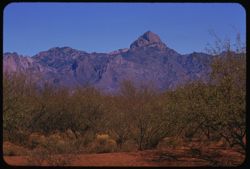
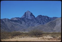
- Description:
- 100 f 8 tl
- Subject:
- Baboquivari Peak (Ariz.), Mountains, and Shrubs
- Series:
- 6-59
- Creator:
- Cushman, Charles W., 1896-1972
- Date Created:
- 1959-01-28
- Genre:
- Landscape photographs
- Frame Number:
- 15
- County:
- Pima
- Abstract:
- Baboquivari from the east
- Call Number:
- P10553
- Country:
- United States
- State/Province:
- Arizona
- Alternate Identifier:
- 659.15
- Persistent URL:
- http://purl.dlib.indiana.edu/iudl/archives/cushman/P10553
-
- Description:
- 100 f 8 tl
- Subject:
- Baboquivari Peak (Ariz.), Mountains, and Shrubs
- Series:
- 6-59
- Creator:
- Cushman, Charles W., 1896-1972
- Date Created:
- 1959-01-28
- Genre:
- Landscape photographs
- Frame Number:
- 30
- County:
- Pima
- Abstract:
- Babo head & shoulders
- Call Number:
- P10568
- Country:
- United States
- State/Province:
- Arizona
- Alternate Identifier:
- 659.30
- Persistent URL:
- http://purl.dlib.indiana.edu/iudl/archives/cushman/P10568
-
- Description:
- 100 f 9 tl
- Subject:
- Baboquivari Mountains (Ariz.), Baboquivari Peak (Ariz.), Mountains, and Shrubs
- Series:
- 9-59
- Creator:
- Cushman, Charles W., 1896-1972
- Date Created:
- 1959-02-20
- Genre:
- Landscape photographs
- Frame Number:
- 1
- County:
- Pima
- Abstract:
- Baboquivari Mtns. from SW
- Call Number:
- P10652
- Country:
- United States
- State/Province:
- Arizona
- Alternate Identifier:
- 959.1
- Persistent URL:
- http://purl.dlib.indiana.edu/iudl/archives/cushman/P10652
-
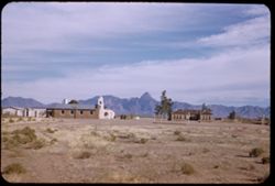
- Description:
- 50 f 8
- Subject:
- Bell towers, Baboquivari Peak (Ariz.), Chapels, Mountains, Churches, Shrubs, Sells (Ariz.), Papago Indian Reservation (Ariz.), and Buildings
- Series:
- 2-52
- Creator:
- Cushman, Charles W., 1896-1972
- Date Created:
- 1952-01-09
- Genre:
- Views
- Frame Number:
- 11
- County:
- Pima
- Abstract:
- Baboquivari Pk from Topawa.
- Call Number:
- P05541
- City:
- Topawa
- Country:
- United States
- State/Province:
- Arizona
- Alternate Identifier:
- 252.11
- Persistent URL:
- http://purl.dlib.indiana.edu/iudl/archives/cushman/P05541
-
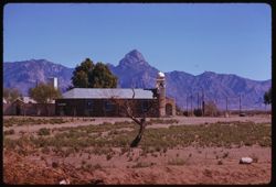
- Description:
- 100 f 8 tl
- Subject:
- Baboquivari Peak (Ariz.), Mountains, Shrubs, Cactus, and Topara
- Series:
- 8-59
- Creator:
- Cushman, Charles W., 1896-1972
- Date Created:
- 1959-02-20
- Genre:
- Landscape photographs
- Frame Number:
- 37
- County:
- Pima
- Abstract:
- Babaoquivari from road south of Topara
- Call Number:
- P10651
- Country:
- United States
- State/Province:
- Arizona
- Alternate Identifier:
- 859.37
- Persistent URL:
- http://purl.dlib.indiana.edu/iudl/archives/cushman/P10651
-
- Description:
- 100 f 8 tl
- Subject:
- Baboquivari Peak (Ariz.), Mountains, and Shrubs
- Series:
- 6-59
- Creator:
- Cushman, Charles W., 1896-1972
- Date Created:
- 1959-01-28
- Genre:
- Landscape photographs
- Frame Number:
- 28
- County:
- Pima
- Abstract:
- Babo head & shoulders
- Call Number:
- P10566
- Country:
- United States
- State/Province:
- Arizona
- Alternate Identifier:
- 659.28
- Persistent URL:
- http://purl.dlib.indiana.edu/iudl/archives/cushman/P10566
-
- Description:
- 100 f 6.3 tl
- Subject:
- Domes, Baboquivari Peak (Ariz.), Automobiles, Arches, Roads, Swings, Mountains, Shrubs, Trees, Buildings, Topara, Bell towers, and Fences
- Series:
- 8-59
- Creator:
- Cushman, Charles W., 1896-1972
- Date Created:
- 1959-02-20
- Genre:
- Landscape photographs
- Frame Number:
- 36
- County:
- Pima
- Abstract:
- Baboquivari Pk seen from Topara
- Call Number:
- P10650
- Country:
- United States
- State/Province:
- Arizona
- Alternate Identifier:
- 859.36
- Persistent URL:
- http://purl.dlib.indiana.edu/iudl/archives/cushman/P10650
-
- Description:
- 100 f 8 tl
- Subject:
- Baboquivari Peak (Ariz.), Mountains, and Shrubs
- Series:
- 6-59
- Creator:
- Cushman, Charles W., 1896-1972
- Date Created:
- 1959-01-28
- Genre:
- Landscape photographs
- Frame Number:
- 22
- County:
- Pima
- Abstract:
- Baboquivari from [S] E
- Call Number:
- P10560
- Country:
- United States
- State/Province:
- Arizona
- Alternate Identifier:
- 659.22
- Persistent URL:
- http://purl.dlib.indiana.edu/iudl/archives/cushman/P10560
-
- Description:
- 100 f 6.3 t
- Subject:
- Baboquivari Peak (Ariz.), Mountains, and Shrubs
- Series:
- 6-59
- Creator:
- Cushman, Charles W., 1896-1972
- Date Created:
- 1959-01-28
- Genre:
- Landscape photographs
- Frame Number:
- 23
- County:
- Pima
- Abstract:
- Baboquivari from SSE
- Call Number:
- P10561
- Country:
- United States
- State/Province:
- Arizona
- Alternate Identifier:
- 659.23
- Persistent URL:
- http://purl.dlib.indiana.edu/iudl/archives/cushman/P10561
-
- Description:
- 100 f 8 tl
- Subject:
- Rocks, Baboquivari Peak (Ariz.), Mountains, and Shrubs
- Series:
- 6-59
- Creator:
- Cushman, Charles W., 1896-1972
- Date Created:
- 1959-01-28
- Genre:
- Landscape photographs
- Frame Number:
- 32
- County:
- Pima
- Abstract:
- Babo head & shoulders from far
- Call Number:
- P10570
- Country:
- United States
- State/Province:
- Arizona
- Alternate Identifier:
- 659.32
- Persistent URL:
- http://purl.dlib.indiana.edu/iudl/archives/cushman/P10570
-
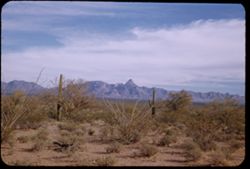
- Description:
- 50 f 8
- Subject:
- Baboquivari Peak (Ariz.), Deserts, Mountains, Shrubs, and Cactus
- Series:
- 2-52
- Creator:
- Cushman, Charles W., 1896-1972
- Date Created:
- 1952-01-09
- Genre:
- Landscape photographs
- Frame Number:
- 10
- Street Address:
- San Miguel Road
- County:
- Pima
- Abstract:
- Baboquivari Pk from Sells - San Miguel Rd.
- Call Number:
- P05540
- City:
- Sells
- Country:
- United States
- State/Province:
- Arizona
- Alternate Identifier:
- 252.10
- Persistent URL:
- http://purl.dlib.indiana.edu/iudl/archives/cushman/P05540
-
- Description:
- 100 f 8 tl
- Subject:
- Baboquivari Peak (Ariz.), Mountains, Fences, and Shrubs
- Series:
- 6-59
- Creator:
- Cushman, Charles W., 1896-1972
- Date Created:
- 1959-01-28
- Genre:
- Landscape photographs
- Frame Number:
- 29
- County:
- Pima
- Abstract:
- Babo head & shoulders
- Call Number:
- P10567
- Country:
- United States
- State/Province:
- Arizona
- Alternate Identifier:
- 659.29
- Persistent URL:
- http://purl.dlib.indiana.edu/iudl/archives/cushman/P10567
-
- Description:
- 100 f 8 tl
- Subject:
- Baboquivari Peak (Ariz.), Mountains, and Shrubs
- Series:
- 6-59
- Creator:
- Cushman, Charles W., 1896-1972
- Date Created:
- 1959-01-28
- Genre:
- Landscape photographs
- Frame Number:
- 21
- County:
- Pima
- Abstract:
- Baboquivari from [S] E
- Call Number:
- P10559
- Country:
- United States
- State/Province:
- Arizona
- Alternate Identifier:
- 659.21
- Persistent URL:
- http://purl.dlib.indiana.edu/iudl/archives/cushman/P10559
-
- Description:
- 100 f 8 tl
- Subject:
- Baboquivari Peak (Ariz.), Mountains, and Shrubs
- Series:
- 6-59
- Creator:
- Cushman, Charles W., 1896-1972
- Date Created:
- 1959-01-28
- Genre:
- Landscape photographs
- Frame Number:
- 24
- County:
- Pima
- Abstract:
- Baboquivari from SSE
- Call Number:
- P10562
- Country:
- United States
- State/Province:
- Arizona
- Alternate Identifier:
- 659.24
- Persistent URL:
- http://purl.dlib.indiana.edu/iudl/archives/cushman/P10562
-
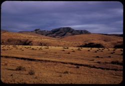
- Description:
- 100 f 8 tl
- Subject:
- Valleys, Roads, Mountains, Shrubs, and Hills
- Series:
- 7-55
- Creator:
- Cushman, Charles W., 1896-1972
- Date Created:
- 1955-03-21
- Genre:
- Landscape photographs
- Frame Number:
- 22
- Street Address:
- Johannesburg Road and Trona Road
- County:
- Kern and San Bernardino
- Abstract:
- Bad Lands west of J - T road
- Call Number:
- P07746
- City:
- Randsburg
- Country:
- United States
- State/Province:
- California
- Alternate Identifier:
- 755.22
- Persistent URL:
- http://purl.dlib.indiana.edu/iudl/archives/cushman/P07746
-
- Description:
- 100 f 6.3 tl
- Subject:
- Deserts, Mojave Desert (Calif.), Electric lines, Dirt roads, Automobiles, Pines, Signs (Notices), Automobile service stations, Mountains, Buildings, Shrubs, ...
- Series:
- 12-55
- Creator:
- Cushman, Charles W., 1896-1972
- Date Created:
- 1955-03-24
- Genre:
- Cityscape photographs
- Frame Number:
- 10
- County:
- San Bernardino
- Abstract:
- Baker
- Call Number:
- P07906
- City:
- Baker
- Country:
- United States
- State/Province:
- California
- Alternate Identifier:
- 1255.10
- Persistent URL:
- http://purl.dlib.indiana.edu/iudl/archives/cushman/P07906
-
- Description:
- 100 f 8 tl
- Subject:
- Snow, Canyons, Trees, Lone Pine Peak (Calif.), Mountains, and Shrubs
- Series:
- 3-55
- Creator:
- Cushman, Charles W., 1896-1972
- Date Created:
- 1955-02-28
- Genre:
- Landscape photographs
- Frame Number:
- 32
- Street Address:
- Mount Whitney Road
- County:
- Inyo
- Abstract:
- Base of Lone Pine Peak
- Call Number:
- P07623
- Country:
- United States
- State/Province:
- California
- Alternate Identifier:
- 355.32
- Persistent URL:
- http://purl.dlib.indiana.edu/iudl/archives/cushman/P07623
-
- Description:
- 50 f 8
- Subject:
- Roads, Fog, Trees, Mountains, Fences, Shrubs, and Hills
- Series:
- 17-54
- Creator:
- Cushman, Charles W., 1896-1972
- Date Created:
- 1954-11-19
- Genre:
- Landscape photographs
- Frame Number:
- 7
- Street Address:
- Skyline Drive
- County:
- San Mateo
- Abstract:
- Fog crossing Skyline Drive - San Mateo county
- Call Number:
- P07527
- Country:
- United States
- State/Province:
- California
- Physical Description:
- Anscochrome film.
- Alternate Identifier:
- 1754.7
- Persistent URL:
- http://purl.dlib.indiana.edu/iudl/archives/cushman/P07527
-
- Description:
- 50 f 11 sl
- Subject:
- Palo verde trees, Trees, Mountains, Shrubs, Tucson Mountains (Ariz.), and Clouds
- Series:
- 8-59
- Creator:
- Cushman, Charles W., 1896-1972
- Date Created:
- 1959-02-13
- Genre:
- Landscape photographs
- Frame Number:
- 7
- County:
- Pima
- Abstract:
- Those lovely clouds above the Tucson Mtns.
- Call Number:
- P10621
- City:
- Tucson
- Country:
- United States
- State/Province:
- Arizona
- Alternate Identifier:
- 859.7
- Persistent URL:
- http://purl.dlib.indiana.edu/iudl/archives/cushman/P10621
-
- Description:
- 100 f 8 tl
- Subject:
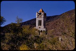
- Rocks, Bell towers, Trees, Arches, Mountains, Shrubs, Clock towers, Scotty's Castle (Calif.), Death Valley (Calif. and Nev.), Columns, Castles & pala...
- Series:
- 11-55
- Creator:
- Cushman, Charles W., 1896-1972
- Date Created:
- 1955-03-23
- Genre:
- Architectural photographs
- Frame Number:
- 28
- County:
- Inyo
- Abstract:
- Scotty's Tower from gate
- Call Number:
- P07887
- Country:
- United States
- State/Province:
- California
- Alternate Identifier:
- 1155.28
- Persistent URL:
- http://purl.dlib.indiana.edu/iudl/archives/cushman/P07887
-
- Description:
- 50 f 8
- Subject:
- Cascade Range, Trees, Volcanoes, Volcanic domes, Lassen Volcanic National Park (Calif.), Lava domes, Shrubs, Black Butte (Siskiyou County, Calif.), Mount Sha...
- Series:
- 6-54
- Creator:
- Cushman, Charles W., 1896-1972
- Date Created:
- 1954-08-20
- Genre:
- Landscape photographs
- Frame Number:
- 27
- County:
- Siskiyou
- Abstract:
- Again - closer [P] This was Black Butte.
- Call Number:
- P07244
- Country:
- United States
- State/Province:
- California
- Alternate Identifier:
- 654.27
- Persistent URL:
- http://purl.dlib.indiana.edu/iudl/archives/cushman/P07244
-
- Description:
- 25 f 11
- Subject:
- Mills, Cascade Range, Trees, Smoke, Volcanoes, Volcanic domes, Lassen Volcanic National Park (Calif.), Lava domes, Shrubs, Black Butte (Siskiyou County, Cali...
- Series:
- 6-54
- Creator:
- Cushman, Charles W., 1896-1972
- Date Created:
- 1954-08-20
- Genre:
- Landscape photographs
- Frame Number:
- 23
- County:
- Siskiyou
- Abstract:
- Triple cone mtn. (Black Butte) from US 99.
- Call Number:
- P07240
- Country:
- United States
- State/Province:
- California
- Alternate Identifier:
- 654.23
- Persistent URL:
- http://purl.dlib.indiana.edu/iudl/archives/cushman/P07240
-
- Description:
- 50 f 9
- Subject:
- Trees, Flowers, Flowering shrubs, Mountains, Shrubs, Black Mountain (Marin County, Calif.), and Hills
- Series:
- 2-54
- Creator:
- Cushman, Charles W., 1896-1972
- Date Created:
- 1954-05-21
- Genre:
- Landscape photographs
- Frame Number:
- 6
- Street Address:
- Lagunitas Road
- County:
- Marin
- Abstract:
- Black Mtn. Again from Lagunitas Rd. - sw. -
- Call Number:
- P07137
- Country:
- United States
- State/Province:
- California
- Alternate Identifier:
- 254.6
- Persistent URL:
- http://purl.dlib.indiana.edu/iudl/archives/cushman/P07137
-
- Description:
- 100 f 5.6 tl
- Subject:
- Rocks, Dantes View (Calif.), Mountains, Shrubs, Clouds, Death Valley (Calif. and Nev.), and Black Mountains (Inyo County, Calif.)
- Series:
- 2-55
- Creator:
- Cushman, Charles W., 1896-1972
- Date Created:
- 1955-02-27
- Genre:
- Landscape photographs
- Frame Number:
- 32
- County:
- Inyo
- Abstract:
- Black Mtns on way to Dante's View from road near Ryan
- Call Number:
- P07589
- City:
- Ryan
- Country:
- United States
- State/Province:
- California
- Alternate Identifier:
- 255.32
- Persistent URL:
- http://purl.dlib.indiana.edu/iudl/archives/cushman/P07589