
Search Constraints
You searched for:
Campus
IUB
Remove constraint Campus: IUB
Subject
Mountains
Remove constraint Subject: Mountains
Subject
Trees
Remove constraint Subject: Trees
« Previous |
1 - 20 of 1,801
|
Next »
Search Results
-
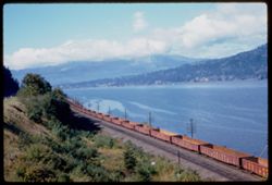
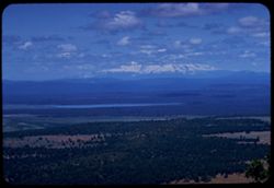
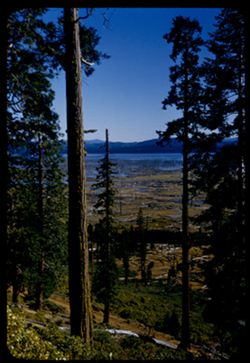
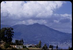
- Description:
- 50 f 6.3
- Subject:
- Railroad freight cars, Union Pacific Railroad Company, Columbia River, Railroad cars, Railroad tracks, Mountains, Utility poles, Electric lines, Trees, Cloud...
- Series:
- 25-60
- Creator:
- Cushman, Charles W., 1896-1972
- Date Created:
- 1960-09-25
- Genre:
- Landscape photographs
- Frame Number:
- 10
- County:
- Hood River
- Abstract:
- Cloud mass above Columbia 16 mi w. of H.R.
- Call Number:
- P11698
- City:
- Hood River
- Country:
- United States
- State/Province:
- Oregon
- Alternate Identifier:
- 2560.10
- Persistent URL:
- http://purl.dlib.indiana.edu/iudl/archives/cushman/P11698
- Holding Location:
- Bloomington - University Archives
Wells Library E460
1320 E 10th St.
Bloomington, IN 47405
Contact at archives@indiana.edu, 812-855-1127
-
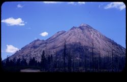
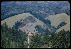
- Description:
- 50 f 8
- Subject:
- Black Butte (Siskiyou County, Calif.), Lava domes, Lassen Volcanic National Park (Calif.), Volcanic domes, Mountains, Shrubs, Trees, Cascade Range, Buttes, C...
- Series:
- 6-54
- Creator:
- Cushman, Charles W., 1896-1972
- Date Created:
- 1954-08-20
- Genre:
- Landscape photographs
- Frame Number:
- 26
- County:
- Siskiyou
- Abstract:
- That same triple cone (Black Butte) west of Mt Shasta.
- Call Number:
- P07243
- Country:
- United States
- State/Province:
- California
- Physical Description:
- masked.
- Alternate Identifier:
- 654.26
- Persistent URL:
- http://purl.dlib.indiana.edu/iudl/archives/cushman/P07243
- Holding Location:
- Bloomington - University Archives
Wells Library E460
1320 E 10th St.
Bloomington, IN 47405
Contact at archives@indiana.edu, 812-855-1127
-
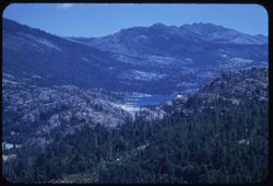
- Description:
- 100 f 5.6 tl
- Subject:
- Lakes & ponds, Mountains, Sierra Nevada (Calif. and Nev.), Trees, Emigrant Gap (Calif. : Gap), and Reservoirs
- Series:
- 15-58
- Creator:
- Cushman, Charles W., 1896-1972
- Date Created:
- 1958-08-22
- Genre:
- Landscape photographs
- Frame Number:
- 4
- Abstract:
- Lake
- Call Number:
- P10110
- Country:
- United States
- State/Province:
- Nevada and California
- Alternate Identifier:
- 1558.4
- Persistent URL:
- http://purl.dlib.indiana.edu/iudl/archives/cushman/P10110
- Holding Location:
- Bloomington - University Archives
Wells Library E460
1320 E 10th St.
Bloomington, IN 47405
Contact at archives@indiana.edu, 812-855-1127
-
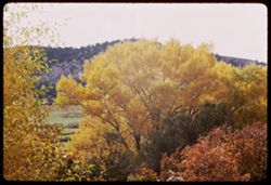
- Description:
- 100 f 11
- Subject:
- Leaves, Tree limbs, Autumn, Mountains, and Trees
- Series:
- 35-65
- Creator:
- Cushman, Charles W., 1896-1972
- Date Created:
- 1965-10-05
- Genre:
- Landscape photographs
- Frame Number:
- 32
- Street Address:
- Colorado State Highway 62
- County:
- Ouray
- Abstract:
- Yellow leaves.
- Call Number:
- P15062
- City:
- Ouray
- Country:
- United States
- State/Province:
- Colorado
- Alternate Identifier:
- 3565.32
- Persistent URL:
- http://purl.dlib.indiana.edu/iudl/archives/cushman/P15062
- Holding Location:
- Bloomington - University Archives
Wells Library E460
1320 E 10th St.
Bloomington, IN 47405
Contact at archives@indiana.edu, 812-855-1127
-
- Description:
- 100 f 8 TL
- Subject:
- Lakes & ponds, Shasta, Mount (Calif. : Mountain), Mountains, Trees, and Clouds
- Series:
- 10-58
- Creator:
- Cushman, Charles W., 1896-1972
- Date Created:
- 1958-06-13
- Genre:
- Landscape photographs
- Frame Number:
- 25
- County:
- Shasta
- Abstract:
- Mt Shasta from SE
- Call Number:
- P09964
- Country:
- United States
- State/Province:
- California
- Alternate Identifier:
- 1058.25
- Persistent URL:
- http://purl.dlib.indiana.edu/iudl/archives/cushman/P09964
- Holding Location:
- Bloomington - University Archives
Wells Library E460
1320 E 10th St.
Bloomington, IN 47405
Contact at archives@indiana.edu, 812-855-1127
-
- Description:
- 100 f 6.3 tl
- Subject:
- Hills, Mountains, Tamalpais, Mount (Calif.), and Trees
- Series:
- 2-56
- Creator:
- Cushman, Charles W., 1896-1972
- Date Created:
- 1956-03-14
- Genre:
- Landscape photographs
- Frame Number:
- 2
- County:
- Marin
- Abstract:
- From road on West shoulder of Mt. Tamalpais: Folded hills to north
- Call Number:
- P08568
- Country:
- United States
- State/Province:
- California
- Alternate Identifier:
- 256.2
- Persistent URL:
- http://purl.dlib.indiana.edu/iudl/archives/cushman/P08568
- Holding Location:
- Bloomington - University Archives
Wells Library E460
1320 E 10th St.
Bloomington, IN 47405
Contact at archives@indiana.edu, 812-855-1127
-
- Description:
- 50 f 11
- Subject:
- Hills, Mountains, Shrubs, Trees, Buttes, and Fences
- Series:
- 18-52
- Creator:
- Cushman, Charles W., 1896-1972
- Date Created:
- 1952-04-15
- Genre:
- Landscape photographs
- Frame Number:
- 29
- Street Address:
- Los Alamos Road
- County:
- Santa Fe
- Abstract:
- View west from same pt as 27.
- Call Number:
- P06160
- City:
- Santa Fe
- Country:
- United States
- State/Province:
- New Mexico
- Alternate Identifier:
- 1852.29
- Persistent URL:
- http://purl.dlib.indiana.edu/iudl/archives/cushman/P06160
- Holding Location:
- Bloomington - University Archives
Wells Library E460
1320 E 10th St.
Bloomington, IN 47405
Contact at archives@indiana.edu, 812-855-1127
-
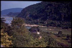
- Subject:
- Jefferson Rock (W. Va.), Railroad tracks, Potomac River, Shrubs, Trees, Rivers, Mountains, and Shenandoah River (Va. and W. Va.)
- Series:
- 16-40
- Creator:
- Cushman, Charles W., 1896-1972
- Date Created:
- 1940-09-16/1940-09-23
- Genre:
- Landscape photographs
- Frame Number:
- 13
- County:
- Jefferson
- Abstract:
- Confluence at Shenandoah and Potomac from Jefferson Rock, Harpers Ferry
- Call Number:
- P02062
- City:
- Harpers Ferry
- Country:
- United States
- State/Province:
- West Virginia
- Physical Description:
- Image was originally mounted in a glass enclosure. Before digitization, the image was removed and placed in a Wess Plastic, Inc. brand, 2" x 2", pl...
- Alternate Identifier:
- 1640.13
- Persistent URL:
- http://purl.dlib.indiana.edu/iudl/archives/cushman/P02062
- Holding Location:
- Bloomington - University Archives
Wells Library E460
1320 E 10th St.
Bloomington, IN 47405
Contact at archives@indiana.edu, 812-855-1127
-
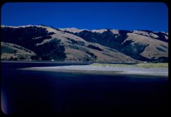
- Description:
- 50 f 8
- Subject:
- Lakes & ponds, Almanor, Lake (Calif.), Bodies of water, Mountains, Shrubs, Trees, Cascade Range, Reservoirs, and Pines
- Series:
- 7-54
- Creator:
- Cushman, Charles W., 1896-1972
- Date Created:
- 1954-08-21
- Genre:
- Landscape photographs
- Frame Number:
- 10
- Street Address:
- California State Highway 36
- County:
- Plumas
- Abstract:
- Lake Almanor from Cal 36.
- Call Number:
- P07265
- Country:
- United States
- State/Province:
- California
- Alternate Identifier:
- 754.10
- Persistent URL:
- http://purl.dlib.indiana.edu/iudl/archives/cushman/P07265
- Holding Location:
- Bloomington - University Archives
Wells Library E460
1320 E 10th St.
Bloomington, IN 47405
Contact at archives@indiana.edu, 812-855-1127
-
- Description:
- 250 f 4.5
- Subject:
- Canyons, Gorge du Loup (France), Cliffs, Mountains, Trees, and Buildings
- Series:
- 8-60
- Creator:
- Cushman, Charles W., 1896-1972
- Date Created:
- 1960-05-16
- Genre:
- Landscape photographs and Cityscape photographs
- Frame Number:
- 23
- County:
- Alpes-Maritimes
- Abstract:
- Gourdons
- Call Number:
- P11123
- City:
- Gourdon and La Colle-sur-Loup
- Country:
- France
- State/Province:
- Provence-Alpes-Côte d'Azur
- Alternate Identifier:
- 860.23
- Persistent URL:
- http://purl.dlib.indiana.edu/iudl/archives/cushman/P11123
- Holding Location:
- Bloomington - University Archives
Wells Library E460
1320 E 10th St.
Bloomington, IN 47405
Contact at archives@indiana.edu, 812-855-1127
-
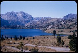
- Description:
- 50 f 8 sl
- Subject:
- Lakes & ponds, Roads, June Lake (Calif.), Mountains, and Trees
- Series:
- 27-55
- Creator:
- Cushman, Charles W., 1896-1972
- Date Created:
- 1955-09-26
- Genre:
- Landscape photographs
- Frame Number:
- 7
- County:
- Mono
- Abstract:
- June Lake
- Call Number:
- P08427
- Country:
- United States
- State/Province:
- California
- Alternate Identifier:
- 2755.7
- Persistent URL:
- http://purl.dlib.indiana.edu/iudl/archives/cushman/P08427
- Holding Location:
- Bloomington - University Archives
Wells Library E460
1320 E 10th St.
Bloomington, IN 47405
Contact at archives@indiana.edu, 812-855-1127
-
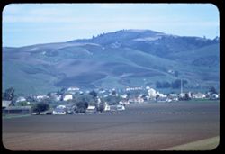
- Description:
- 100 f 4.5 TL
- Subject:
- Croplands, Streets, Hills, Agricultural machinery & implements, Mountains, Trees, Farms, Farming, and Houses
- Series:
- 2-60
- Creator:
- Cushman, Charles W., 1896-1972
- Date Created:
- 1960-03-10
- Genre:
- Cityscape photographs
- Frame Number:
- 16
- County:
- San Mateo
- Abstract:
- From ht wsw of tower
- Call Number:
- P10947
- City:
- Pescadero
- Country:
- United States
- State/Province:
- California
- Alternate Identifier:
- 260.16
- Persistent URL:
- http://purl.dlib.indiana.edu/iudl/archives/cushman/P10947
- Holding Location:
- Bloomington - University Archives
Wells Library E460
1320 E 10th St.
Bloomington, IN 47405
Contact at archives@indiana.edu, 812-855-1127
-
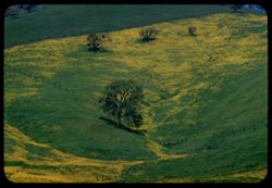
- Description:
- 100 f 8 TL
- Subject:
- Diablo, Mount (Calif.), Meadows, Flowers, Hills, Mustard (Plant), Mountains, Trees, Grasses, and Fences
- Series:
- 2-60
- Creator:
- Cushman, Charles W., 1896-1972
- Date Created:
- 1960-03-25
- Genre:
- Landscape photographs
- Frame Number:
- 28
- County:
- Contra Costa
- Abstract:
- Mustard & grass SE of Clayton
- Call Number:
- P10959
- City:
- Clayton
- Country:
- United States
- State/Province:
- California
- Alternate Identifier:
- 260.28
- Persistent URL:
- http://purl.dlib.indiana.edu/iudl/archives/cushman/P10959
- Holding Location:
- Bloomington - University Archives
Wells Library E460
1320 E 10th St.
Bloomington, IN 47405
Contact at archives@indiana.edu, 812-855-1127
-
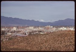
- Description:
- 100 f 6.3 tl
- Subject:
- Domes, Cities & towns, Streets, Automobiles, Mountains, Tucson Mountains (Ariz.), Shrubs, Trees, Buildings, Signs (Notices), Clouds, and Dwellings
- Series:
- 8-59
- Creator:
- Cushman, Charles W., 1896-1972
- Date Created:
- 1959-02-11
- Genre:
- Cityscape photographs
- Frame Number:
- 4
- County:
- Pima
- Abstract:
- Tucson from A Mtn.
- Call Number:
- P10618
- City:
- Tucson
- Country:
- United States
- State/Province:
- Arizona
- Alternate Identifier:
- 859.4
- Persistent URL:
- http://purl.dlib.indiana.edu/iudl/archives/cushman/P10618
- Holding Location:
- Bloomington - University Archives
Wells Library E460
1320 E 10th St.
Bloomington, IN 47405
Contact at archives@indiana.edu, 812-855-1127
-
- Description:
- 25 f 8 Pola
- Subject:
- Lakes & ponds, Houses, Bodies of water, Sand, Mountains, Waterfronts, Trees, Beaches, Grasses, and Hills
- Series:
- 7-53
- Creator:
- Cushman, Charles W., 1896-1972
- Date Created:
- 1953-07-08
- Genre:
- Landscape photographs
- Frame Number:
- 29
- County:
- Marin
- Abstract:
- Across Bolinas lagoon from Bolinas.
- Call Number:
- P06753
- City:
- Bolinas
- Country:
- United States
- State/Province:
- California
- Alternate Identifier:
- 753.29
- Persistent URL:
- http://purl.dlib.indiana.edu/iudl/archives/cushman/P06753
- Holding Location:
- Bloomington - University Archives
Wells Library E460
1320 E 10th St.
Bloomington, IN 47405
Contact at archives@indiana.edu, 812-855-1127
-

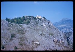
- Description:
- 100 f 5.6
- Subject:
- Steeples, Cathedrals, Mirabellgarten (Salzburg, Austria), Pedestrians, Forts & fortifications, Mountains, Shrubs, Fountains, Trees, Gates, Festung Hohens...
- Series:
- 8-64
- Creator:
- Cushman, Charles W., 1896-1972
- Date Created:
- 1964-05-21
- Genre:
- Cityscape photographs and Views
- Frame Number:
- 4
- Abstract:
- Hohensalzberg Fortress from Mirabell Garden
- Call Number:
- P13206
- City:
- Salzburg
- Country:
- Austria
- State/Province:
- Salzburg
- Alternate Identifier:
- 864.4
- Persistent URL:
- http://purl.dlib.indiana.edu/iudl/archives/cushman/P13206
- Holding Location:
- Bloomington - University Archives
Wells Library E460
1320 E 10th St.
Bloomington, IN 47405
Contact at archives@indiana.edu, 812-855-1127
-
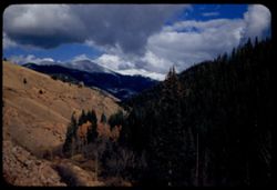
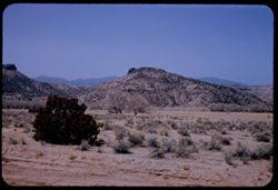
- Description:
- 50 f 8 Pola
- Subject:
- Passes (Landforms), Roads, Mountains, Shrubs, Snow, Trees, Rocks, Kenosha Pass (Colo.), Railings, Kenosha Mountains (Colo.), and Clouds
- Series:
- 10-53
- Creator:
- Cushman, Charles W., 1896-1972
- Date Created:
- 1953-10-14
- Genre:
- Landscape photographs
- Frame Number:
- 22
- County:
- Park
- Abstract:
- NE from Kenosha Pass
- Call Number:
- P06862
- Country:
- United States
- State/Province:
- Colorado
- Alternate Identifier:
- 1053.22
- Persistent URL:
- http://purl.dlib.indiana.edu/iudl/archives/cushman/P06862
- Holding Location:
- Bloomington - University Archives
Wells Library E460
1320 E 10th St.
Bloomington, IN 47405
Contact at archives@indiana.edu, 812-855-1127
-
- Description:
- 100 f 5.6 tl
- Subject:
- Valleys, Hills, Bodies of water, Roads, Mountains, Tamalpais, Mount (Calif.), Trees, Buildings, Clouds, Dwellings, and Utility poles
- Series:
- 5-55
- Creator:
- Cushman, Charles W., 1896-1972
- Date Created:
- 1955-03-10
- Genre:
- Landscape photographs
- Frame Number:
- 4
- County:
- Marin
- Abstract:
- Cloud mass above Mt. Tamalpais from top of Sausalito All of frame will next to 3
- Call Number:
- P07669
- City:
- Sausalito
- Country:
- United States
- State/Province:
- California
- Alternate Identifier:
- 555.4
- Persistent URL:
- http://purl.dlib.indiana.edu/iudl/archives/cushman/P07669
- Holding Location:
- Bloomington - University Archives
Wells Library E460
1320 E 10th St.
Bloomington, IN 47405
Contact at archives@indiana.edu, 812-855-1127
-
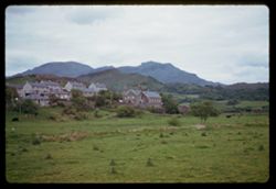
- Description:
- 250 f 2
- Subject:
- Meadows, Houses, Mountains, Trees, and Hills
- Series:
- 11-61
- Creator:
- Cushman, Charles W., 1896-1972
- Date Created:
- 1961-05-24
- Genre:
- Landscape photographs and Cityscape photographs
- Frame Number:
- 36
- County:
- Merioneth
- Abstract:
- Merioneth mtns
- Call Number:
- P12120
- Country:
- United Kingdom
- State/Province:
- Wales
- Alternate Identifier:
- 1161.36
- Persistent URL:
- http://purl.dlib.indiana.edu/iudl/archives/cushman/P12120
- Holding Location:
- Bloomington - University Archives
Wells Library E460
1320 E 10th St.
Bloomington, IN 47405
Contact at archives@indiana.edu, 812-855-1127
-
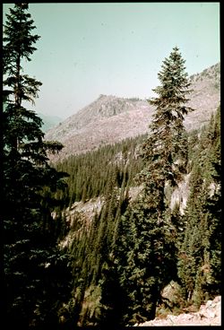
- Subject:
- Mount Rainier National Park (Wash.), National parks & reserves, Forests, Mountains, Shrubs, Trees, and Rocks
- Series:
- 4-38
- Creator:
- Cushman, Charles W., 1896-1972
- Date Created:
- 1938-09-21/1938-09-22
- Genre:
- Landscape photographs
- Frame Number:
- 34
- Abstract:
- D-34= Mountain scene near Chinook Pass.
- Call Number:
- P01463
- Country:
- United States
- State/Province:
- Washington
- Physical Description:
- Color corrected: magenta cast [fading of yellow dye]. Image was originally mounted in a glass enclosure. Before digitization, the image was removed and place...
- Alternate Identifier:
- 438.34
- Persistent URL:
- http://purl.dlib.indiana.edu/iudl/archives/cushman/P01463
- Holding Location:
- Bloomington - University Archives
Wells Library E460
1320 E 10th St.
Bloomington, IN 47405
Contact at archives@indiana.edu, 812-855-1127