
Search Constraints
You searched for:
Campus
IUB
Remove constraint Campus: IUB
Subject
Rocks
Remove constraint Subject: Rocks
Subject
Valleys
Remove constraint Subject: Valleys
Subject
Death Valley (Calif. and Nev.)
Remove constraint Subject: Death Valley (Calif. and Nev.)
1 - 27 of 27
Search Results
-
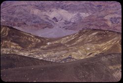
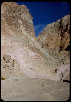
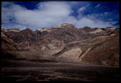
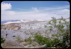
- Description:
- 100 f 8 tl
- Subject:
- Rocks, Valleys, Ubehebe Crater (Calif.), Shrubs, Death Valley (Calif. and Nev.), and Mountains
- Series:
- 11-55
- Creator:
- Cushman, Charles W., 1896-1972
- Date Created:
- 1955-03-23
- Genre:
- Landscape photographs
- Frame Number:
- 26
- County:
- Inyo
- Abstract:
- Ridges NE of crater long at right corrected
- Call Number:
- P07885
- Country:
- United States
- State/Province:
- California
- Alternate Identifier:
- 1155.26
- Persistent URL:
- http://purl.dlib.indiana.edu/iudl/archives/cushman/P07885
- Holding Location:
- Bloomington - University Archives
Wells Library E460
1320 E 10th St.
Bloomington, IN 47405
Contact at archives@indiana.edu, 812-855-1127
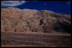
-
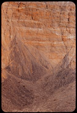
- Description:
- 100 f 8 tl
- Subject:
- Valleys, Death Valley (Calif. and Nev.), Craters, Shrubs, Rocks, and Ubehebe Crater (Calif.)
- Series:
- 11-55
- Creator:
- Cushman, Charles W., 1896-1972
- Date Created:
- 1955-03-23
- Genre:
- Landscape photographs
- Frame Number:
- 21
- County:
- Inyo
- Abstract:
- East wall
- Call Number:
- P07881
- Country:
- United States
- State/Province:
- California
- Alternate Identifier:
- 1155.21
- Persistent URL:
- http://purl.dlib.indiana.edu/iudl/archives/cushman/P07881
- Holding Location:
- Bloomington - University Archives
Wells Library E460
1320 E 10th St.
Bloomington, IN 47405
Contact at archives@indiana.edu, 812-855-1127
-
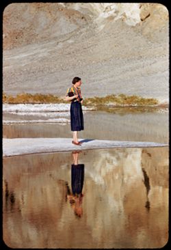
- Description:
- 100 f 5.6 tl
- Subject:
- Rocks, Valleys, Bodies of water, Spouses, Minerals, Salt, Shrubs, Death Valley (Calif. and Nev.), and Reflections
- Series:
- 10-55
- Creator:
- Cushman, Charles W., 1896-1972
- Date Created:
- 1955-03-22
- Genre:
- Portraits and Identification photographs
- Frame Number:
- 17
- County:
- Inyo
- Persons Pictured:
- Cushman, Jean
- Abstract:
- Jean at BW End of Mar. 22
- Call Number:
- P07842
- City:
- Badwater
- Country:
- United States
- State/Province:
- California
- Alternate Identifier:
- 1055.17
- Persistent URL:
- http://purl.dlib.indiana.edu/iudl/archives/cushman/P07842
- Holding Location:
- Bloomington - University Archives
Wells Library E460
1320 E 10th St.
Bloomington, IN 47405
Contact at archives@indiana.edu, 812-855-1127
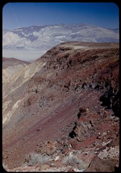
-
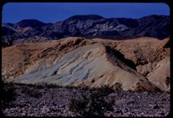
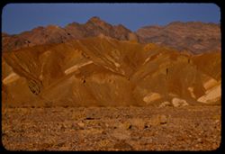
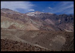
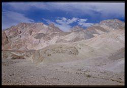
- Description:
- 100 f 8 tl
- Subject:
- Rocks, Valleys, Mountains, Shrubs, Death Valley (Calif. and Nev.), Black Mountains (Inyo County, Calif.), and Hills
- Series:
- 8-55
- Creator:
- Cushman, Charles W., 1896-1972
- Date Created:
- 1955-03-22
- Genre:
- Landscape photographs
- Frame Number:
- 22
- Street Address:
- Dante's View Road
- County:
- Inyo
- Abstract:
- colored rock in valley from closer (along Dante's V. rd.
- Call Number:
- P07780
- Country:
- United States
- State/Province:
- California
- Alternate Identifier:
- 855.22
- Persistent URL:
- http://purl.dlib.indiana.edu/iudl/archives/cushman/P07780
- Holding Location:
- Bloomington - University Archives
Wells Library E460
1320 E 10th St.
Bloomington, IN 47405
Contact at archives@indiana.edu, 812-855-1127
-
- Description:
- 100 f 5.6 tl
- Subject:
- Rocks, Valleys, Funeral Mountains (Calif.), Mountains, Shrubs, Death Valley (Calif. and Nev.), and Furnace Creek Inn (Death Valley Junction, Calif.)
- Series:
- 8-55
- Creator:
- Cushman, Charles W., 1896-1972
- Date Created:
- 1955-03-21
- Genre:
- Landscape photographs
- Frame Number:
- 14
- County:
- Inyo
- Abstract:
- Funeral mtns just north of Furnace CR Inn
- Call Number:
- P07772
- City:
- Death Valley Junction
- Country:
- United States
- State/Province:
- California
- Alternate Identifier:
- 855.14
- Persistent URL:
- http://purl.dlib.indiana.edu/iudl/archives/cushman/P07772
- Holding Location:
- Bloomington - University Archives
Wells Library E460
1320 E 10th St.
Bloomington, IN 47405
Contact at archives@indiana.edu, 812-855-1127
-
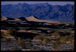
- Description:
- 100 f 6.3 tl
- Subject:
- Rocks, Valleys, Grapevine Mountains (Calif. and Nev.), Dunes, Mountains, Shrubs, and Death Valley (Calif. and Nev.)
- Series:
- 8-55
- Creator:
- Cushman, Charles W., 1896-1972
- Date Created:
- 1955-03-21
- Genre:
- Landscape photographs
- Frame Number:
- 6
- County:
- Inyo
- Abstract:
- S Sand dunes and Grapevine Mtns. north of road a mile or 2 e. of S.P.W. SD
- Call Number:
- P07766
- City:
- Stovepipe Wells
- Country:
- United States
- State/Province:
- California
- Physical Description:
- Image was originally mounted in a glass enclosure. Before digitization, the image was removed and placed in a Wess Plastic, Inc. brand, 2" x 2", pl...
- Alternate Identifier:
- 855.6
- Persistent URL:
- http://purl.dlib.indiana.edu/iudl/archives/cushman/P07766
- Holding Location:
- Bloomington - University Archives
Wells Library E460
1320 E 10th St.
Bloomington, IN 47405
Contact at archives@indiana.edu, 812-855-1127
-
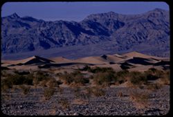
- Description:
- 100 f 8 tl
- Subject:
- Valleys, Hills, Grapevine Mountains (Calif. and Nev.), Death Valley (Calif. and Nev.), Mountains, Shrubs, Rocks, and Dunes
- Series:
- 8-55
- Creator:
- Cushman, Charles W., 1896-1972
- Date Created:
- 1955-03-21
- Genre:
- Landscape photographs
- Frame Number:
- 5
- County:
- Inyo
- Abstract:
- S Sand dunes and Grapevine Mtns. north of road a mile or 2 e. of S.P.W. SD
- Call Number:
- P07765
- City:
- Stovepipe Wells
- Country:
- United States
- State/Province:
- California
- Alternate Identifier:
- 855.5
- Persistent URL:
- http://purl.dlib.indiana.edu/iudl/archives/cushman/P07765
- Holding Location:
- Bloomington - University Archives
Wells Library E460
1320 E 10th St.
Bloomington, IN 47405
Contact at archives@indiana.edu, 812-855-1127
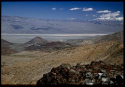
-
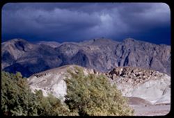
- Description:
- 200 f 4.5 tl
- Subject:
- Rocks, Canyons, Trees, Mountains, Clouds, Death Valley National Park (Calif. and Nev.), Death Valley (Calif. and Nev.), Valleys, and Funeral Mountains (Calif.)
- Series:
- 3-55
- Creator:
- Cushman, Charles W., 1896-1972
- Date Created:
- 1955-02-27
- Genre:
- Landscape photographs
- Frame Number:
- 24
- Abstract:
- Funeral Mtns from near Park Hdqtrs
- Call Number:
- P07615
- Country:
- United States
- State/Province:
- California
- Alternate Identifier:
- 355.24
- Persistent URL:
- http://purl.dlib.indiana.edu/iudl/archives/cushman/P07615
- Holding Location:
- Bloomington - University Archives
Wells Library E460
1320 E 10th St.
Bloomington, IN 47405
Contact at archives@indiana.edu, 812-855-1127
-
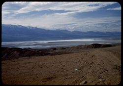
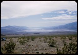
- Description:
- 200 f 5.6
- Subject:
- Valleys, Death Valley (Calif. and Nev.), Mountains, Shrubs, Rocks, and Clouds
- Series:
- 3-55
- Creator:
- Cushman, Charles W., 1896-1972
- Date Created:
- 1955-02-27
- Genre:
- Landscape photographs
- Frame Number:
- 14
- Abstract:
- Toward D Valley from 100 ft. elev.
- Call Number:
- P07606
- Country:
- United States
- State/Province:
- Nevada and California
- Alternate Identifier:
- 355.14
- Persistent URL:
- http://purl.dlib.indiana.edu/iudl/archives/cushman/P07606
- Holding Location:
- Bloomington - University Archives
Wells Library E460
1320 E 10th St.
Bloomington, IN 47405
Contact at archives@indiana.edu, 812-855-1127
-

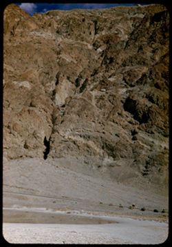
- Description:
- 25 f 13
- Subject:
- Rocks, Colored mountains, Valleys, Cliffs, Mountains, Rock formations, Death Valley (Calif. and Nev.), Deserts, and Hills
- Series:
- 15-52
- Creator:
- Cushman, Charles W., 1896-1972
- Date Created:
- 1952-04-09
- Genre:
- Landscape photographs
- Frame Number:
- 38
- Street Address:
- Artists Drive
- County:
- Inyo
- Abstract:
- From top of Artists Drive. Off Artists Drive.
- Call Number:
- P06057
- Country:
- United States
- State/Province:
- California
- Alternate Identifier:
- 1552.38
- Persistent URL:
- http://purl.dlib.indiana.edu/iudl/archives/cushman/P06057
- Holding Location:
- Bloomington - University Archives
Wells Library E460
1320 E 10th St.
Bloomington, IN 47405
Contact at archives@indiana.edu, 812-855-1127
-
- Description:
- 25 f 16
- Subject:
- Rocks, Valleys, Cliffs, Boulders, Mountains, Death Valley (Calif. and Nev.), and Deserts
- Series:
- 15-52
- Creator:
- Cushman, Charles W., 1896-1972
- Date Created:
- 1952-04-09
- Genre:
- Landscape photographs
- Frame Number:
- 37
- Street Address:
- Artists Drive
- County:
- Inyo
- Abstract:
- From top of Artists Drive. Up from Artists Dr.
- Call Number:
- P06056
- Country:
- United States
- State/Province:
- California
- Alternate Identifier:
- 1552.37
- Persistent URL:
- http://purl.dlib.indiana.edu/iudl/archives/cushman/P06056
- Holding Location:
- Bloomington - University Archives
Wells Library E460
1320 E 10th St.
Bloomington, IN 47405
Contact at archives@indiana.edu, 812-855-1127
-
- Description:
- 25 f 8 Pola
- Subject:
- Deserts, Valleys, Hills, Death Valley (Calif. and Nev.), Mountains, Rocks, and Clouds
- Series:
- 15-52
- Creator:
- Cushman, Charles W., 1896-1972
- Date Created:
- 1952-04-09
- Genre:
- Landscape photographs
- Frame Number:
- 35
- Street Address:
- Artists Drive
- County:
- Inyo
- Abstract:
- From top of Artists Drive. Back across valley.
- Call Number:
- P06054
- Country:
- United States
- State/Province:
- California
- Alternate Identifier:
- 1552.35
- Persistent URL:
- http://purl.dlib.indiana.edu/iudl/archives/cushman/P06054
- Holding Location:
- Bloomington - University Archives
Wells Library E460
1320 E 10th St.
Bloomington, IN 47405
Contact at archives@indiana.edu, 812-855-1127
-
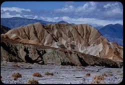
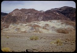
- Description:
- 25 f 13
- Subject:
- Rocks, Colored mountains, Valleys, Cliffs, Boulders, Mountains, Rock formations, Death Valley (Calif. and Nev.), Deserts, and Hills
- Series:
- 15-52
- Creator:
- Cushman, Charles W., 1896-1972
- Date Created:
- 1952-04-09
- Genre:
- Landscape photographs
- Frame Number:
- 33
- Street Address:
- Artists Drive
- County:
- Inyo
- Abstract:
- Colored mtns from Artists Drive.
- Call Number:
- P06052
- Country:
- United States
- State/Province:
- California
- Physical Description:
- Image was originally mounted in a glass enclosure. Before digitization, the image was removed and placed in a Wess Plastic, Inc. brand, 2" x 2", pl...
- Alternate Identifier:
- 1552.33
- Persistent URL:
- http://purl.dlib.indiana.edu/iudl/archives/cushman/P06052
- Holding Location:
- Bloomington - University Archives
Wells Library E460
1320 E 10th St.
Bloomington, IN 47405
Contact at archives@indiana.edu, 812-855-1127
-
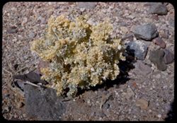
- Description:
- 25 f 16
- Subject:
- Valleys, Rocks, Death Valley (Calif. and Nev.), Deserts, and Shrubs
- Series:
- 15-52
- Creator:
- Cushman, Charles W., 1896-1972
- Date Created:
- 1952-04-09
- Genre:
- Identification photographs
- Frame Number:
- 32
- County:
- Inyo
- Abstract:
- Desert holly.
- Call Number:
- P06051
- Country:
- United States
- State/Province:
- California
- Alternate Identifier:
- 1552.32
- Persistent URL:
- http://purl.dlib.indiana.edu/iudl/archives/cushman/P06051
- Holding Location:
- Bloomington - University Archives
Wells Library E460
1320 E 10th St.
Bloomington, IN 47405
Contact at archives@indiana.edu, 812-855-1127
-
- Description:
- 25 f 13
- Subject:
- Deserts, Valleys, Mountains, Hills, Rocks, and Death Valley (Calif. and Nev.)
- Series:
- 15-52
- Creator:
- Cushman, Charles W., 1896-1972
- Date Created:
- 1952-04-09
- Genre:
- Landscape photographs
- Frame Number:
- 31
- Street Address:
- Artists Drive
- County:
- Inyo
- Abstract:
- Mtns from Atrists Drive.
- Call Number:
- P06050
- Country:
- United States
- State/Province:
- California
- Physical Description:
- Image was originally mounted in a glass enclosure. Before digitization, the image was removed and placed in a Wess Plastic, Inc. brand, 2" x 2", pl...
- Alternate Identifier:
- 1552.31
- Persistent URL:
- http://purl.dlib.indiana.edu/iudl/archives/cushman/P06050
- Holding Location:
- Bloomington - University Archives
Wells Library E460
1320 E 10th St.
Bloomington, IN 47405
Contact at archives@indiana.edu, 812-855-1127
-
- Description:
- 25 f 9 Pola
- Subject:
- Lakes & ponds, Deserts, Valleys, Death Valley (Calif. and Nev.), Roads, Cliffs, Mountains, Boulders, and Rocks
- Series:
- 15-52
- Creator:
- Cushman, Charles W., 1896-1972
- Date Created:
- 1952-04-09
- Genre:
- Snapshots
- Frame Number:
- 29
- County:
- Inyo
- Abstract:
- Mtns at Bad Water, 279.6 ft. below
- Call Number:
- P06049
- City:
- Badwater
- Country:
- United States
- State/Province:
- California
- Alternate Identifier:
- 1552.29
- Persistent URL:
- http://purl.dlib.indiana.edu/iudl/archives/cushman/P06049
- Holding Location:
- Bloomington - University Archives
Wells Library E460
1320 E 10th St.
Bloomington, IN 47405
Contact at archives@indiana.edu, 812-855-1127
-
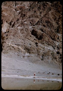
- Description:
- 25 f 13
- Subject:
- Lakes & ponds, Deserts, Reflections, Valleys, Death Valley (Calif. and Nev.), Roads, Cliffs, Mountains, Women, Boulders, and Rocks
- Series:
- 15-52
- Creator:
- Cushman, Charles W., 1896-1972
- Date Created:
- 1952-04-09
- Genre:
- Portraits and Snapshots
- Frame Number:
- 28
- County:
- Inyo
- Persons Pictured:
- Cushman, Jean
- Abstract:
- Mtns at Bad Water, 279.6 ft. below.
- Call Number:
- P06048
- City:
- Badwater
- Country:
- United States
- State/Province:
- California
- Alternate Identifier:
- 1552.28
- Persistent URL:
- http://purl.dlib.indiana.edu/iudl/archives/cushman/P06048
- Holding Location:
- Bloomington - University Archives
Wells Library E460
1320 E 10th St.
Bloomington, IN 47405
Contact at archives@indiana.edu, 812-855-1127
-
- Description:
- 25 f 11 Pola
- Subject:
- Deserts, Amargosa Range (Nev. and Calif.), Valleys, Death Valley (Calif. and Nev.), Mountains, and Rocks
- Series:
- 15-52
- Creator:
- Cushman, Charles W., 1896-1972
- Date Created:
- 1952-04-09
- Genre:
- Landscape photographs
- Frame Number:
- 27
- County:
- Inyo
- Abstract:
- Amargosa Mtns near Bad Water.
- Call Number:
- P06047
- City:
- Badwater
- Country:
- United States
- State/Province:
- California
- Physical Description:
- Image was originally mounted in a glass enclosure. Before digitization, the image was removed and placed in a Wess Plastic, Inc. brand, 2" x 2", pl...
- Alternate Identifier:
- 1552.27
- Persistent URL:
- http://purl.dlib.indiana.edu/iudl/archives/cushman/P06047
- Holding Location:
- Bloomington - University Archives
Wells Library E460
1320 E 10th St.
Bloomington, IN 47405
Contact at archives@indiana.edu, 812-855-1127
-
- Description:
- 25 f 9 Pola
- Subject:
- Deserts, Valleys, Mountains, Death Valley (Calif. and Nev.), Amargosa Range (Nev. and Calif.), and Rocks
- Series:
- 15-52
- Creator:
- Cushman, Charles W., 1896-1972
- Date Created:
- 1952-04-09
- Genre:
- Landscape photographs
- Frame Number:
- 26
- County:
- Inyo
- Abstract:
- Amargosa Mtns near Bad Water.
- Call Number:
- P06046
- City:
- Badwater
- Country:
- United States
- State/Province:
- California
- Physical Description:
- Image was originally mounted in a glass enclosure. Before digitization, the image was removed and placed in a Wess Plastic, Inc. brand, 2" x 2", pl...
- Alternate Identifier:
- 1552.26
- Persistent URL:
- http://purl.dlib.indiana.edu/iudl/archives/cushman/P06046
- Holding Location:
- Bloomington - University Archives
Wells Library E460
1320 E 10th St.
Bloomington, IN 47405
Contact at archives@indiana.edu, 812-855-1127
-
- Description:
- 25 f 9 Pola
- Subject:
- Deserts, Valleys, Salt pools, Mountains, Shrubs, Hills, Black Mountains (Inyo County, Calif.), Rocks, and Death Valley (Calif. and Nev.)
- Series:
- 15-52
- Creator:
- Cushman, Charles W., 1896-1972
- Date Created:
- 1952-04-09
- Genre:
- Landscape photographs
- Frame Number:
- 24
- County:
- Inyo
- Abstract:
- Colored Mtns. The Black Mtns - near Salt Pools this time.
- Call Number:
- P06044
- Country:
- United States
- State/Province:
- California
- Alternate Identifier:
- 1552.24
- Persistent URL:
- http://purl.dlib.indiana.edu/iudl/archives/cushman/P06044
- Holding Location:
- Bloomington - University Archives
Wells Library E460
1320 E 10th St.
Bloomington, IN 47405
Contact at archives@indiana.edu, 812-855-1127
-

- Description:
- 25 f 9 Pola
- Subject:
- Deserts, Valleys, Hills, Death Valley (Calif. and Nev.), Mountains, Colored mountains, Rocks, Rock formations, and Black Mountains (Inyo County, Calif.)
- Series:
- 15-52
- Creator:
- Cushman, Charles W., 1896-1972
- Date Created:
- 1952-04-09
- Genre:
- Landscape photographs
- Frame Number:
- 23
- County:
- Inyo
- Abstract:
- Colored Mtns. The Black Mtns.
- Call Number:
- P06043
- Country:
- United States
- State/Province:
- California
- Alternate Identifier:
- 1552.23
- Persistent URL:
- http://purl.dlib.indiana.edu/iudl/archives/cushman/P06043
- Holding Location:
- Bloomington - University Archives
Wells Library E460
1320 E 10th St.
Bloomington, IN 47405
Contact at archives@indiana.edu, 812-855-1127
-
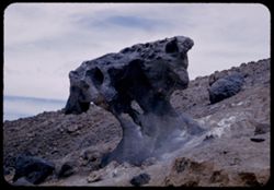
- Description:
- 25 f 10
- Subject:
- Deserts, Mushroom Rock (Inyo County, Calif.), Boulders, Rock formations, Hills, Rocks, Valleys, and Death Valley (Calif. and Nev.)
- Series:
- 15-52
- Creator:
- Cushman, Charles W., 1896-1972
- Date Created:
- 1952-04-09
- Genre:
- Snapshots
- Frame Number:
- 22
- County:
- Inyo
- Abstract:
- Mushroom rock.
- Call Number:
- P06042
- City:
- Furnace Creek
- Country:
- United States
- State/Province:
- California
- Alternate Identifier:
- 1552.22
- Persistent URL:
- http://purl.dlib.indiana.edu/iudl/archives/cushman/P06042
- Holding Location:
- Bloomington - University Archives
Wells Library E460
1320 E 10th St.
Bloomington, IN 47405
Contact at archives@indiana.edu, 812-855-1127
-

- Description:
- 25 f 14
- Subject:
- Deserts, Amargosa Range (Nev. and Calif.), Valleys, Hills, Death Valley (Calif. and Nev.), Cliffs, Mountains, Shrubs, Rocks, Canyons, and Desolation Canyon (...
- Series:
- 15-52
- Creator:
- Cushman, Charles W., 1896-1972
- Date Created:
- 1952-04-09
- Genre:
- Landscape photographs
- Frame Number:
- 21
- Street Address:
- Bad Water Road
- County:
- Inyo
- Abstract:
- Approx. same.
- Call Number:
- P06041
- City:
- Furnace Creek
- Country:
- United States
- State/Province:
- California
- Alternate Identifier:
- 1552.21
- Persistent URL:
- http://purl.dlib.indiana.edu/iudl/archives/cushman/P06041
- Holding Location:
- Bloomington - University Archives
Wells Library E460
1320 E 10th St.
Bloomington, IN 47405
Contact at archives@indiana.edu, 812-855-1127
-
- Description:
- 25 f 13
- Subject:
- Rocks, Mesquite, Valleys, Cliffs, Women, Mountains, Shrubs, Death Valley (Calif. and Nev.), Utility poles, Furnace Creek (Calif.), and Hills
- Series:
- 15-52
- Creator:
- Cushman, Charles W., 1896-1972
- Date Created:
- 1952-04-09
- Genre:
- Landscape photographs and Portraits
- Frame Number:
- 14
- County:
- Inyo
- Persons Pictured:
- Cushman, Jean
- Abstract:
- Mesquite and green rocks. (near Furnace Creek)
- Call Number:
- P06035
- Country:
- United States
- State/Province:
- California
- Alternate Identifier:
- 1552.14
- Persistent URL:
- http://purl.dlib.indiana.edu/iudl/archives/cushman/P06035
- Holding Location:
- Bloomington - University Archives
Wells Library E460
1320 E 10th St.
Bloomington, IN 47405
Contact at archives@indiana.edu, 812-855-1127
-
- Description:
- 25 f 6.3 Pola
- Subject:
- Deserts, Valleys, Hills, Automobiles, Death Valley (Calif. and Nev.), Roads, Mountains, Shrubs, and Rocks
- Series:
- 15-52
- Creator:
- Cushman, Charles W., 1896-1972
- Date Created:
- 1952-04-09
- Genre:
- Landscape photographs
- Frame Number:
- 12
- County:
- Inyo
- Abstract:
- Death Valley from north.
- Call Number:
- P06033
- City:
- Beatty Junction
- Country:
- United States
- State/Province:
- California
- Alternate Identifier:
- 1552.12
- Persistent URL:
- http://purl.dlib.indiana.edu/iudl/archives/cushman/P06033
- Holding Location:
- Bloomington - University Archives
Wells Library E460
1320 E 10th St.
Bloomington, IN 47405
Contact at archives@indiana.edu, 812-855-1127
-
- Description:
- 25 f 8 Pola
- Subject:
- Deserts, Valleys, Roads, Mountains, Shrubs, Panamint Valley (Calif.), Hills, Rocks, Panamint Range (Calif.), and Death Valley (Calif. and Nev.)
- Series:
- 15-52
- Creator:
- Cushman, Charles W., 1896-1972
- Date Created:
- 1952-04-08
- Genre:
- Landscape photographs
- Frame Number:
- 6
- County:
- Inyo
- Abstract:
- Road is straight across Panamint Valley.
- Call Number:
- P06027
- Country:
- United States
- State/Province:
- California
- Physical Description:
- Image was originally mounted in a glass enclosure. Before digitization, the image was removed and placed in a Wess Plastic, Inc. brand, 2" x 2", pl...
- Alternate Identifier:
- 1552.6
- Persistent URL:
- http://purl.dlib.indiana.edu/iudl/archives/cushman/P06027
- Holding Location:
- Bloomington - University Archives
Wells Library E460
1320 E 10th St.
Bloomington, IN 47405
Contact at archives@indiana.edu, 812-855-1127
-
- Description:
- 25 f 8 Pola
- Subject:
- Deserts, Valleys, Panamint Range (Calif.), Panamint Mountains (Calif.), Argus Range (Calif.), Mountains, Shrubs, Panamint Valley (Calif.), Death Valley (Cali...
- Series:
- 15-52
- Creator:
- Cushman, Charles W., 1896-1972
- Date Created:
- 1952-04-08
- Genre:
- Landscape photographs
- Frame Number:
- 4
- County:
- Inyo
- Abstract:
- Same [P]
- Call Number:
- P06025
- Country:
- United States
- State/Province:
- California
- Alternate Identifier:
- 1552.4
- Persistent URL:
- http://purl.dlib.indiana.edu/iudl/archives/cushman/P06025
- Holding Location:
- Bloomington - University Archives
Wells Library E460
1320 E 10th St.
Bloomington, IN 47405
Contact at archives@indiana.edu, 812-855-1127