
Search Constraints
You searched for:
Campus
IUB
Remove constraint Campus: IUB
Subject
Shrubs
Remove constraint Subject: Shrubs
State/Province
Arizona
Remove constraint State/Province: Arizona
« Previous |
1 - 100 of 412
|
Next »
Search Results
-
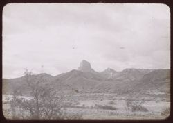
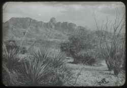
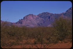
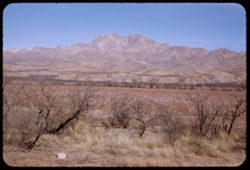
- Subject:
- Baboquivari Peak Wilderness (Ariz.), Trees, Mountains, and Shrubs
- Series:
- 22-40
- Creator:
- Cushman, Charles W., 1896-1972
- Date Created:
- 1940-05-01
- Genre:
- Landscape photographs
- Frame Number:
- 9
- County:
- Pima
- Abstract:
- 40 - F - 9 = Baboquivari Peak nr. Ariz. - Sonora line
- Call Number:
- P01506
- Country:
- United States and Mexico
- State/Province:
- Arizona and Sonora
- Physical Description:
- black & white .
- Alternate Identifier:
- 2240.9
- Persistent URL:
- http://purl.dlib.indiana.edu/iudl/archives/cushman/P01506
-
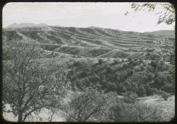
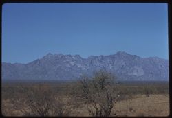
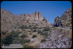
- Subject:
- Trees, Mountains, Shrubs, and Santa Rita Mountains (Ariz.)
- Series:
- 22-40
- Creator:
- Cushman, Charles W., 1896-1972
- Date Created:
- 1940-05-01
- Genre:
- Landscape photographs
- Frame Number:
- 11
- County:
- Pima
- Abstract:
- 40 - F- 11= Ariz. Ridged landscape s.e. of Tucson
- Call Number:
- P01826
- City:
- Tucson
- Country:
- United States
- State/Province:
- Arizona
- Physical Description:
- black & white .
- Alternate Identifier:
- 2240.11
- Persistent URL:
- http://purl.dlib.indiana.edu/iudl/archives/cushman/P01826
-
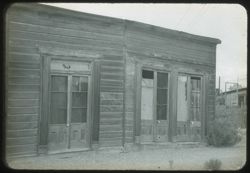
- Subject:
- Trees, Fences, Shrubs, Wooden buildings, and Doors & doorways
- Series:
- 22-40
- Creator:
- Cushman, Charles W., 1896-1972
- Date Created:
- 1940-05-01
- Frame Number:
- 13
- County:
- Cochise
- Abstract:
- 40-F-13= in Tombstone, Ariz.
- Call Number:
- P01508
- City:
- Tombstone
- Country:
- United States
- State/Province:
- Arizona
- Physical Description:
- black & white .
- Alternate Identifier:
- 2240.13
- Persistent URL:
- http://purl.dlib.indiana.edu/iudl/archives/cushman/P01508
-
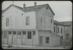
- Subject:
- Schieffelin House (Tombstone, Ariz.), Windows, Sidewalks, Dirt roads, Shrubs, Electric lines, Trees, Buildings, and Doors & doorways
- Series:
- 22-40
- Creator:
- Cushman, Charles W., 1896-1972
- Date Created:
- 1940-05-01
- Genre:
- Architectural photographs
- Frame Number:
- 15
- County:
- Cochise
- Abstract:
- 40-F-15= in Tombstone, Ariz.
- Call Number:
- P01509
- City:
- Tombstone
- Country:
- United States
- State/Province:
- Arizona
- Physical Description:
- black & white .
- Alternate Identifier:
- 2240.15
- Persistent URL:
- http://purl.dlib.indiana.edu/iudl/archives/cushman/P01509
-
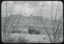
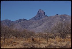
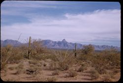
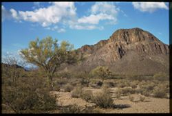
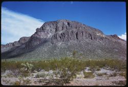
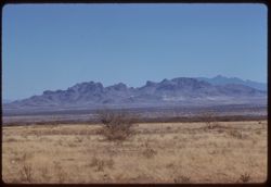
- Subject:
- Baboquivari Peak Wilderness (Ariz.), Mountains, and Shrubs
- Series:
- 22-40
- Creator:
- Cushman, Charles W., 1896-1972
- Date Created:
- 1940-04-01
- Genre:
- Landscape photographs
- Frame Number:
- 24
- County:
- Pima
- Abstract:
- 40-F-24 = Baboquivari Peak nr. Ariz.-Sonora line
- Call Number:
- P01510
- Country:
- United States and Mexico
- State/Province:
- Arizona and Sonora
- Physical Description:
- black & white .
- Alternate Identifier:
- 2240.24
- Persistent URL:
- http://purl.dlib.indiana.edu/iudl/archives/cushman/P01510
-
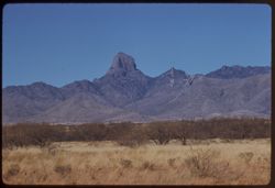
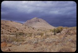
- Subject:
- Baboquivari Peak Wilderness (Ariz.), Mountains, Shrubs, and Clouds
- Series:
- 22-40
- Creator:
- Cushman, Charles W., 1896-1972
- Date Created:
- 1940-05-01
- Genre:
- Landscape photographs
- Frame Number:
- 25
- County:
- Pima
- Abstract:
- 40-F-25= Baboquivari Peak nr. Ariz. - Sonora line
- Call Number:
- P01511
- Country:
- United States and Mexico
- State/Province:
- Arizona and Sonora
- Physical Description:
- black & white .
- Alternate Identifier:
- 2240.25
- Persistent URL:
- http://purl.dlib.indiana.edu/iudl/archives/cushman/P01511
-
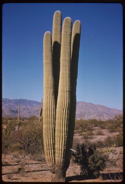
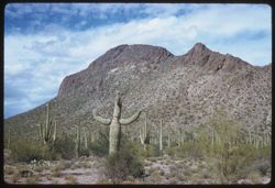
- Description:
- 50 f 11 sl
- Subject:
- Deserts, Cactus, Mountains, Shrubs, and Saguaro National Park (Ariz.)
- Series:
- 10-59
- Creator:
- Cushman, Charles W., 1896-1972
- Date Created:
- 1959-03-05
- Genre:
- Identification photographs
- Frame Number:
- 15
- County:
- Pima
- Abstract:
- A 4 in 1 Saguaro
- Call Number:
- P10703
- City:
- Tucson
- Country:
- United States
- State/Province:
- Arizona
- Alternate Identifier:
- 1059.15
- Persistent URL:
- http://purl.dlib.indiana.edu/iudl/archives/cushman/P10703
-
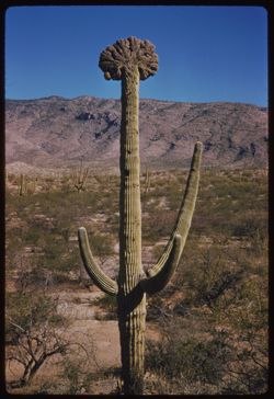
- Description:
- 50 f 11 sl
- Subject:
- Deserts, Cristate saguaro, Cactus, Mountains, Shrubs, and Saguaro National Park (Ariz.)
- Series:
- 10-59
- Creator:
- Cushman, Charles W., 1896-1972
- Date Created:
- 1959-03-05
- Genre:
- Identification photographs
- Frame Number:
- 9
- County:
- Pima
- Abstract:
- A fine cristate
- Call Number:
- P10697
- City:
- Tucson
- Country:
- United States
- State/Province:
- Arizona
- Alternate Identifier:
- 1059.9
- Persistent URL:
- http://purl.dlib.indiana.edu/iudl/archives/cushman/P10697
-
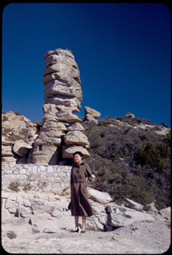
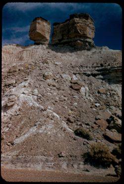
- Description:
- 50 f 9
- Subject:
- Rocks, Women, Coats, Mountains, Shrubs, Santa Catalina Mountains (Ariz.), and Rock formations
- Series:
- 4-52
- Creator:
- Cushman, Charles W., 1896-1972
- Date Created:
- 1952-01-25
- Genre:
- Landscape photographs and Portraits
- Frame Number:
- 19
- Street Address:
- Mount Lemmon Road
- Abstract:
- Jean to a chimney rock
- Call Number:
- P05625
- Country:
- United States
- State/Province:
- Arizona
- Alternate Identifier:
- 452.19
- Persistent URL:
- http://purl.dlib.indiana.edu/iudl/archives/cushman/P05625
-
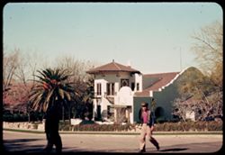
- Subject:
- Stone walls, Vines, Streets, Arches, Sidewalks, People, Dwellings, Trees, Railings, Balconies, and Shrubs
- Series:
- 1-40
- Creator:
- Cushman, Charles W., 1896-1972
- Date Created:
- 1940-02-01
- Genre:
- Architectural photographs
- Frame Number:
- 17
- Street Address:
- Snob Hollow
- County:
- Pima
- Abstract:
- A house in Snob Hollow.
- Call Number:
- P01753
- City:
- Tucson
- Country:
- United States
- State/Province:
- Arizona
- Alternate Identifier:
- 140.17
- Persistent URL:
- http://purl.dlib.indiana.edu/iudl/archives/cushman/P01753
-
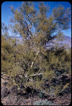
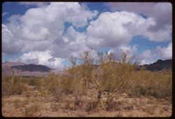
- Description:
- 25 f 11
- Subject:
- Deserts, Trees, Parkinsonia aculeata, Mountains, National parks & reserves, Saguaro National Park (Ariz.), and Shrubs
- Series:
- 3-52
- Creator:
- Cushman, Charles W., 1896-1972
- Date Created:
- 1952-01-15
- Genre:
- Identification photographs
- Frame Number:
- 8
- County:
- Pima
- Abstract:
- A Palo Verde
- Call Number:
- P05577
- City:
- Tucson
- Country:
- United States
- State/Province:
- Arizona
- Alternate Identifier:
- 352.8
- Persistent URL:
- http://purl.dlib.indiana.edu/iudl/archives/cushman/P05577
-
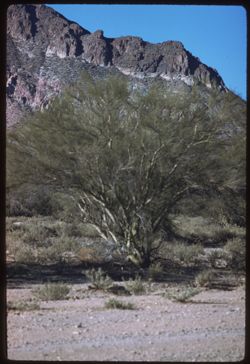
- Description:
- 100 f 5.6 tl
- Subject:
- Palo verde trees, Trees, Mountains, Shrubs, and Tucson Mountains (Ariz.)
- Series:
- 6-59
- Creator:
- Cushman, Charles W., 1896-1972
- Date Created:
- 1959-01-25
- Genre:
- Identification photographs
- Frame Number:
- 6
- County:
- Pima
- Abstract:
- A palo verde
- Call Number:
- P10544
- City:
- Tucson
- Country:
- United States
- State/Province:
- Arizona
- Alternate Identifier:
- 659.6
- Persistent URL:
- http://purl.dlib.indiana.edu/iudl/archives/cushman/P10544
-
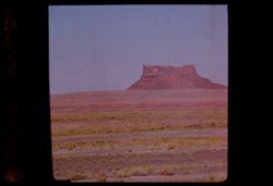
- Description:
- 100 f 8 tl
- Subject:
- Rocks, Cactus, Buttes, Mountains, Shrubs, Tucson Mountains (Ariz.), and Clouds
- Series:
- 7-59
- Creator:
- Cushman, Charles W., 1896-1972
- Date Created:
- 1959-02-02
- Genre:
- Landscape photographs
- Frame Number:
- 3
- Street Address:
- Ajo Way
- County:
- Pima
- Abstract:
- A small butte commercialized
- Call Number:
- P10579
- City:
- Tucson
- Country:
- United States
- State/Province:
- Arizona
- Alternate Identifier:
- 759.3
- Persistent URL:
- http://purl.dlib.indiana.edu/iudl/archives/cushman/P10579
-
- Description:
- 50 f 6.3
- Subject:
- Hills, Mountains, Shrubs, Snow, Mingus Mountain (Ariz.), Grasses, and Rocks
- Series:
- 15-53
- Creator:
- Cushman, Charles W., 1896-1972
- Date Created:
- 1953-11-21
- Genre:
- Landscape photographs and Cityscape photographs
- Frame Number:
- 15
- County:
- Yavapai
- Abstract:
- Looking back toward Jerome and Mingus Mtn from Clarkdale
- Call Number:
- P07049
- City:
- Clarkdale and Jerome
- Country:
- United States
- State/Province:
- Arizona
- Physical Description:
- Image was originally mounted in a glass enclosure. Before digitization, the image was removed and placed in a Wess Plastic, Inc. brand, 2" x 2", pl...
- Alternate Identifier:
- 1553.15
- Persistent URL:
- http://purl.dlib.indiana.edu/iudl/archives/cushman/P07049
-
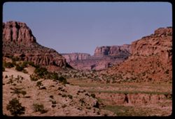
- Description:
- 100 f 11 SL
- Subject:
- Rocks, Canyons, Erosion, Cliffs, Trees, Rock formations, Oak Creek Canyon (Ariz.), and Shrubs
- Series:
- 5-62
- Creator:
- Cushman, Charles W., 1896-1972
- Date Created:
- 1962-10-05
- Genre:
- Landscape photographs
- Frame Number:
- 2
- County:
- Coconino
- Abstract:
- 3 mi. north of Sedona
- Call Number:
- P12769
- City:
- Sedona
- Country:
- United States
- State/Province:
- Arizona
- Alternate Identifier:
- 562.2
- Persistent URL:
- http://purl.dlib.indiana.edu/iudl/archives/cushman/P12769
-
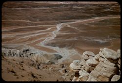
- Description:
- 25 f 13
- Subject:
- Sabino Canyon (Ariz.), Canyons, Saguaro, Cliffs, Mountains, Shrubs, Santa Catalina Mountains (Ariz.), Rock formations, and Cactus
- Series:
- 5-52
- Creator:
- Cushman, Charles W., 1896-1972
- Date Created:
- 1952-02-04
- Genre:
- Landscape photographs
- Frame Number:
- 25
- County:
- Pima
- Abstract:
- Pent house - at left - and the square castle - late
- Call Number:
- P05670
- Country:
- United States
- State/Province:
- Arizona
- Alternate Identifier:
- 552.25
- Persistent URL:
- http://purl.dlib.indiana.edu/iudl/archives/cushman/P05670
-
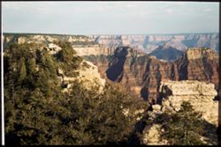
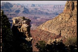
- Subject:
- National parks & reserves, Canyons, Bright Angel Point (Ariz.), Cliffs, Shrubs, Trees, and Grand Canyon (Ariz.)
- Series:
- 12-40
- Creator:
- Cushman, Charles W., 1896-1972
- Date Created:
- 1940-07-12
- Genre:
- Landscape photographs
- Frame Number:
- 14
- County:
- Coconino
- Abstract:
- Across tip of B.A.Pt., past temples to opp. Rim.
- Call Number:
- P01993
- Country:
- United States
- State/Province:
- Arizona
- Physical Description:
- Image was originally mounted in a glass enclosure. Before digitization, the image was removed and placed in a Wess Plastic, Inc. brand, 2" x 2", pl...
- Alternate Identifier:
- 1240.14
- Persistent URL:
- http://purl.dlib.indiana.edu/iudl/archives/cushman/P01993
-
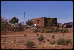
- Description:
- 100 f 9 tl
- Subject:
- Electric lines, Adobe houses, Cactus, Automobiles, Trees, Clotheslines, Pots & pans, Papago Indian Reservation (Ariz.), and Shrubs
- Series:
- 8-59
- Creator:
- Cushman, Charles W., 1896-1972
- Date Created:
- 1959-02-20
- Genre:
- Architectural photographs
- Frame Number:
- 35
- County:
- Pima
- Abstract:
- Adobe hut- Sells Agency
- Call Number:
- P10649
- City:
- Sells
- Country:
- United States
- State/Province:
- Arizona
- Alternate Identifier:
- 859.35
- Persistent URL:
- http://purl.dlib.indiana.edu/iudl/archives/cushman/P10649
-
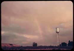
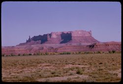
- Subject:
- Rainbows, Electric lines, Rincon Mountains (Ariz.), Trees, Mountains, Shrubs, Bridges, Utility poles, Water towers, and Clouds
- Series:
- 1-40
- Creator:
- Cushman, Charles W., 1896-1972
- Date Created:
- 1940-02-01
- Genre:
- Landscape photographs and Snapshots
- Frame Number:
- 10
- County:
- Pima
- Abstract:
- Afternoon rainbow over Rincon Mtns.
- Call Number:
- P01747
- City:
- Tucson
- Country:
- United States
- State/Province:
- Arizona
- Alternate Identifier:
- 140.10
- Persistent URL:
- http://purl.dlib.indiana.edu/iudl/archives/cushman/P01747
-
- Description:
- 100 f 11 TL
- Subject:
- Rocks, Sightseers, Men, Petrified forests, Trees, Petrified Forest National Park (Ariz.), National parks & reserves, Agate Bridge (Ariz.), Shrubs, and Ro...
- Series:
- 5-63
- Creator:
- Cushman, Charles W., 1896-1972
- Date Created:
- 1963-06-27
- Genre:
- Landscape photographs and Identification photographs
- Frame Number:
- 35
- County:
- Apache and Navajo
- Abstract:
- Agate Bridge
- Call Number:
- P12951
- City:
- Holbrook
- Country:
- United States
- State/Province:
- Arizona
- Alternate Identifier:
- 563.35
- Persistent URL:
- http://purl.dlib.indiana.edu/iudl/archives/cushman/P12951
-
- Description:
- 25 f 11 Pola
- Subject:
- Agate Bridge (Ariz.), Petrified forests, Trees, Petrified Forest National Park (Ariz.), Shrubs, Agates, National parks & reserves, and Rock formations
- Series:
- 18-52
- Creator:
- Cushman, Charles W., 1896-1972
- Date Created:
- 1952-04-13
- Genre:
- Landscape photographs and Identification photographs
- Frame Number:
- 1
- County:
- Apache and Navajo
- Abstract:
- Agate Bridge.
- Call Number:
- P06132
- City:
- Holbrook
- Country:
- United States
- State/Province:
- Arizona
- Physical Description:
- masked.
- Alternate Identifier:
- 1852.1
- Persistent URL:
- http://purl.dlib.indiana.edu/iudl/archives/cushman/P06132
-
- Description:
- 100 f 16 SL
- Subject:
- Rock formations, Grasses, Mesas, Boundaries, Indian reservations, Navajo Indian Reservation, Cliffs, Smoke, Trees, and Shrubs
- Series:
- 36-65
- Creator:
- Cushman, Charles W., 1896-1972
- Date Created:
- 1965-10-08
- Genre:
- Landscape photographs
- Frame Number:
- 35
- County:
- Apache
- Abstract:
- Temple.
- Call Number:
- P15103
- City:
- Window Rock
- Country:
- United States
- State/Province:
- Arizona and New Mexico
- Alternate Identifier:
- 3665.35
- Persistent URL:
- http://purl.dlib.indiana.edu/iudl/archives/cushman/P15103
-
- Description:
- 100 f 11 SL
- Subject:
- Valleys, Grasses, Monument Valley (Ariz. and Utah), Deserts, Cliffs, Rock formations, and Shrubs
- Series:
- 37-65
- Creator:
- Cushman, Charles W., 1896-1972
- Date Created:
- 1965-10-09
- Genre:
- Landscape photographs
- Frame Number:
- 9
- Street Address:
- Arizona State Highway 64 and Navajo Trail
- County:
- Navajo
- Abstract:
- Red stone.
- Call Number:
- P15115
- City:
- Kayenta
- Country:
- United States
- State/Province:
- Arizona
- Alternate Identifier:
- 3765.9
- Persistent URL:
- http://purl.dlib.indiana.edu/iudl/archives/cushman/P15115
-
- Description:
- 25 f 9 Pola
- Subject:
- Canyons, Roads, Barbed wire, Trees, Tree limbs, Mountains, Fences, Shrubs, Clouds, Oak Creek Canyon (Ariz.), and Rock formations
- Series:
- 16-52
- Creator:
- Cushman, Charles W., 1896-1972
- Date Created:
- 1952-04-12
- Genre:
- Landscape photographs
- Frame Number:
- 33
- Street Address:
- United States Highway 89A
- County:
- Coconino
- Call Number:
- P06091
- City:
- Flagstaff
- Country:
- United States
- State/Province:
- Arizona
- Physical Description:
- Image was originally mounted in a glass enclosure. Before digitization, the image was removed and placed in a Wess Plastic, Inc. brand, 2" x 2", pl...
- Alternate Identifier:
- 1652.33
- Persistent URL:
- http://purl.dlib.indiana.edu/iudl/archives/cushman/P06091
-
- Subject:
- Deserts, Roskruge Mountains (Ariz.), Mountains, Shrubs, Cactus, and Clouds
- Series:
- 5-40
- Creator:
- Cushman, Charles W., 1896-1972
- Date Created:
- 1940-05-01
- Genre:
- Landscape photographs
- Frame Number:
- 17
- County:
- Pima
- Abstract:
- An Arizona desert . Roskruge Mtns. In distance. View is northeast.
- Call Number:
- P01835
- Country:
- United States
- State/Province:
- Arizona
- Physical Description:
- Image was originally mounted in a glass enclosure. Before digitization, the image was removed and placed in a Wess Plastic, Inc. brand, 2" x 2", pl...
- Alternate Identifier:
- 540.17
- Persistent URL:
- http://purl.dlib.indiana.edu/iudl/archives/cushman/P01835
-
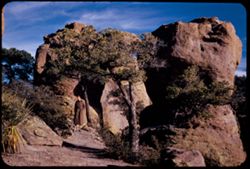
- Description:
- 100 f 11 TL
- Subject:
- Cliffs, Arches, Navajo National Monument (Ariz.), Rock formations, National parks & reserves, and Shrubs
- Series:
- 38-65
- Creator:
- Cushman, Charles W., 1896-1972
- Date Created:
- 1965-10-11
- Genre:
- Landscape photographs
- Frame Number:
- 31
- County:
- Navajo
- Abstract:
- Arch
- Call Number:
- P15174
- City:
- Kayenta
- Country:
- United States
- State/Province:
- Arizona
- Alternate Identifier:
- 3865.31
- Persistent URL:
- http://purl.dlib.indiana.edu/iudl/archives/cushman/P15174
-
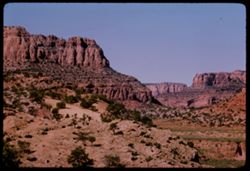
- Description:
- 100 f 11
- Subject:
- Hills, Roads, Cliffs, Mountains, Shrubs, Trees, and Grasses
- Series:
- 5-62
- Creator:
- Cushman, Charles W., 1896-1972
- Date Created:
- 1962-10-05
- Genre:
- Landscape photographs
- Frame Number:
- 16
- County:
- Coconino
- Abstract:
- East from 6 or 7 mi. west of Sedona
- Call Number:
- P12783
- City:
- Sedona
- Country:
- United States
- State/Province:
- Arizona
- Alternate Identifier:
- 562.16
- Persistent URL:
- http://purl.dlib.indiana.edu/iudl/archives/cushman/P12783
-
- Description:
- 100 f 13 ?
- Subject:
- Cliffs, Cactus, Trees, Mountains, Shrubs, and Hills
- Series:
- 5-62
- Creator:
- Cushman, Charles W., 1896-1972
- Date Created:
- 1962-10-05
- Genre:
- Landscape photographs
- Frame Number:
- 15
- County:
- Coconino
- Abstract:
- East from 6 or 7 mi west of Sedona
- Call Number:
- P12782
- City:
- Sedona
- Country:
- United States
- State/Province:
- Arizona
- Alternate Identifier:
- 562.15
- Persistent URL:
- http://purl.dlib.indiana.edu/iudl/archives/cushman/P12782
-
- Description:
- 50 f 6.3 POLA
- Subject:
- Grasses, Cliffs, Mesas, Mountains, Fences, Shrubs, Clouds, Hills, and Trees
- Series:
- 15-53
- Creator:
- Cushman, Charles W., 1896-1972
- Date Created:
- 1953-11-21
- Genre:
- Landscape photographs
- Frame Number:
- 18
- Street Address:
- United States Highway 89A
- County:
- Coconino
- Abstract:
- View North
- Call Number:
- P07051
- City:
- Sedona
- Country:
- United States
- State/Province:
- Arizona
- Alternate Identifier:
- 1553.18
- Persistent URL:
- http://purl.dlib.indiana.edu/iudl/archives/cushman/P07051
-
- Description:
- 25 f 8 Pola
- Subject:
- Plains, Hills, Barbed wire, Shrubs, Clouds, Mists, and Fences
- Series:
- 16-52
- Creator:
- Cushman, Charles W., 1896-1972
- Date Created:
- 1952-04-11
- Genre:
- Landscape photographs
- Frame Number:
- 13
- Street Address:
- United States Highway 66
- County:
- Yavapai
- Abstract:
- View SW from US 66 east of Seligman-showing rare mist formation
- Call Number:
- P06071
- City:
- Seligman
- Country:
- United States
- State/Province:
- Arizona
- Physical Description:
- Image was originally mounted in a glass enclosure. Before digitization, the image was removed and placed in a Wess Plastic, Inc. brand, 2" x 2", pl...
- Alternate Identifier:
- 1652.13
- Persistent URL:
- http://purl.dlib.indiana.edu/iudl/archives/cushman/P06071
-
- Description:
- 100 f 13 ?
- Subject:
- Cliffs, Cactus, Trees, Mountains, Shrubs, and Hills
- Series:
- 5-62
- Creator:
- Cushman, Charles W., 1896-1972
- Date Created:
- 1962-10-05
- Genre:
- Landscape photographs
- Frame Number:
- 14
- County:
- Coconino
- Abstract:
- East from 6 or 7 mi west of Sedona
- Call Number:
- P12781
- City:
- Sedona
- Country:
- United States
- State/Province:
- Arizona
- Alternate Identifier:
- 562.14
- Persistent URL:
- http://purl.dlib.indiana.edu/iudl/archives/cushman/P12781
-
- Description:
- 100 f 9
- Subject:
- Hills, Roads, Cliffs, Mountains, Shrubs, Trees, and Grasses
- Series:
- 5-62
- Creator:
- Cushman, Charles W., 1896-1972
- Date Created:
- 1962-10-05
- Genre:
- Landscape photographs
- Frame Number:
- 17
- County:
- Coconino
- Abstract:
- East from 6 or 7 mi. west of Sedona
- Call Number:
- P12784
- City:
- Sedona
- Country:
- United States
- State/Province:
- Arizona
- Alternate Identifier:
- 562.17
- Persistent URL:
- http://purl.dlib.indiana.edu/iudl/archives/cushman/P12784
-
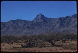
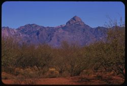
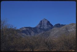
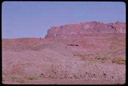
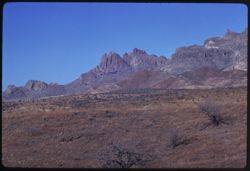
- Description:
- 100 f 9 tl
- Subject:
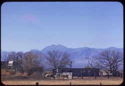
- Baboquivari Mountains (Ariz.), Baboquivari Peak (Ariz.), Mountains, and Shrubs
- Series:
- 9-59
- Creator:
- Cushman, Charles W., 1896-1972
- Date Created:
- 1959-02-20
- Genre:
- Landscape photographs
- Frame Number:
- 2
- County:
- Pima
- Abstract:
- His neighbor to north
- Call Number:
- P10653
- Country:
- United States
- State/Province:
- Arizona
- Alternate Identifier:
- 959.2
- Persistent URL:
- http://purl.dlib.indiana.edu/iudl/archives/cushman/P10653
-
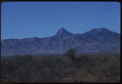
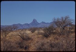
- Description:
- 100 f 9 tl
- Subject:
- Baboquivari Peak (Ariz.), Mountains, Shrubs, and Grasses
- Series:
- 6-59
- Creator:
- Cushman, Charles W., 1896-1972
- Date Created:
- 1959-01-28
- Genre:
- Landscape photographs
- Frame Number:
- 17
- County:
- Pima
- Abstract:
- Broadside view of Babo. range further north of PK.
- Call Number:
- P10555
- Country:
- United States
- State/Province:
- Arizona
- Alternate Identifier:
- 659.17
- Persistent URL:
- http://purl.dlib.indiana.edu/iudl/archives/cushman/P10555
-
- Description:
- 100 f 8 tl
- Subject:
- Baboquivari Peak (Ariz.), Mountains, Fences, and Shrubs
- Series:
- 6-59
- Creator:
- Cushman, Charles W., 1896-1972
- Date Created:
- 1959-01-28
- Genre:
- Landscape photographs
- Frame Number:
- 27
- County:
- Pima
- Abstract:
- Babo
- Call Number:
- P10565
- Country:
- United States
- State/Province:
- Arizona
- Alternate Identifier:
- 659.27
- Persistent URL:
- http://purl.dlib.indiana.edu/iudl/archives/cushman/P10565
-
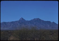
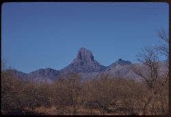
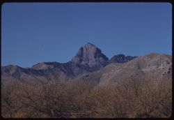
- Description:
- 100 f 9 tl
- Subject:
- Baboquivari Peak (Ariz.), Mountains, and Shrubs
- Series:
- 6-59
- Creator:
- Cushman, Charles W., 1896-1972
- Date Created:
- 1959-01-28
- Genre:
- Landscape photographs
- Frame Number:
- 31
- County:
- Pima
- Abstract:
- Babo head & shoulders
- Call Number:
- P10569
- Country:
- United States
- State/Province:
- Arizona
- Alternate Identifier:
- 659.31
- Persistent URL:
- http://purl.dlib.indiana.edu/iudl/archives/cushman/P10569
-
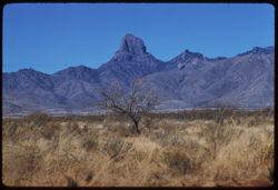
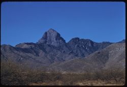
- Description:
- 100 f 8 tl
- Subject:
- Baboquivari Peak (Ariz.), Mountains, and Shrubs
- Series:
- 6-59
- Creator:
- Cushman, Charles W., 1896-1972
- Date Created:
- 1959-01-28
- Genre:
- Landscape photographs
- Frame Number:
- 20
- County:
- Pima
- Abstract:
- Baboquivari
- Call Number:
- P10558
- Country:
- United States
- State/Province:
- Arizona
- Alternate Identifier:
- 659.20
- Persistent URL:
- http://purl.dlib.indiana.edu/iudl/archives/cushman/P10558
-
- Description:
- 100 f 8 tl
- Subject:
- Baboquivari Peak (Ariz.), Mountains, and Shrubs
- Series:
- 6-59
- Creator:
- Cushman, Charles W., 1896-1972
- Date Created:
- 1959-01-28
- Genre:
- Landscape photographs
- Frame Number:
- 16
- County:
- Pima
- Abstract:
- Baboquivari from the east, from farther south (7864' elev)
- Call Number:
- P10554
- Country:
- United States
- State/Province:
- Arizona
- Alternate Identifier:
- 659.16
- Persistent URL:
- http://purl.dlib.indiana.edu/iudl/archives/cushman/P10554
-
- Description:
- 100 f 8 tl
- Subject:
- Baboquivari Peak (Ariz.), Mountains, and Shrubs
- Series:
- 6-59
- Creator:
- Cushman, Charles W., 1896-1972
- Date Created:
- 1959-01-28
- Genre:
- Landscape photographs
- Frame Number:
- 15
- County:
- Pima
- Abstract:
- Baboquivari from the east
- Call Number:
- P10553
- Country:
- United States
- State/Province:
- Arizona
- Alternate Identifier:
- 659.15
- Persistent URL:
- http://purl.dlib.indiana.edu/iudl/archives/cushman/P10553
-
- Description:
- 100 f 8 tl
- Subject:
- Baboquivari Peak (Ariz.), Mountains, and Shrubs
- Series:
- 6-59
- Creator:
- Cushman, Charles W., 1896-1972
- Date Created:
- 1959-01-28
- Genre:
- Landscape photographs
- Frame Number:
- 30
- County:
- Pima
- Abstract:
- Babo head & shoulders
- Call Number:
- P10568
- Country:
- United States
- State/Province:
- Arizona
- Alternate Identifier:
- 659.30
- Persistent URL:
- http://purl.dlib.indiana.edu/iudl/archives/cushman/P10568
-
- Description:
- 100 f 9 tl
- Subject:
- Baboquivari Mountains (Ariz.), Baboquivari Peak (Ariz.), Mountains, and Shrubs
- Series:
- 9-59
- Creator:
- Cushman, Charles W., 1896-1972
- Date Created:
- 1959-02-20
- Genre:
- Landscape photographs
- Frame Number:
- 1
- County:
- Pima
- Abstract:
- Baboquivari Mtns. from SW
- Call Number:
- P10652
- Country:
- United States
- State/Province:
- Arizona
- Alternate Identifier:
- 959.1
- Persistent URL:
- http://purl.dlib.indiana.edu/iudl/archives/cushman/P10652
-
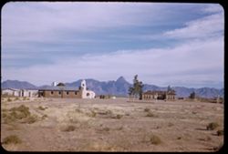
- Description:
- 50 f 8
- Subject:
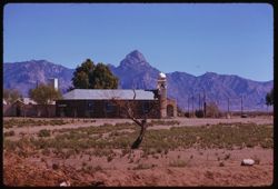
- Bell towers, Baboquivari Peak (Ariz.), Chapels, Mountains, Churches, Shrubs, Sells (Ariz.), Papago Indian Reservation (Ariz.), and Buildings
- Series:
- 2-52
- Creator:
- Cushman, Charles W., 1896-1972
- Date Created:
- 1952-01-09
- Genre:
- Views
- Frame Number:
- 11
- County:
- Pima
- Abstract:
- Baboquivari Pk from Topawa.
- Call Number:
- P05541
- City:
- Topawa
- Country:
- United States
- State/Province:
- Arizona
- Alternate Identifier:
- 252.11
- Persistent URL:
- http://purl.dlib.indiana.edu/iudl/archives/cushman/P05541
-
- Description:
- 100 f 8 tl
- Subject:
- Baboquivari Peak (Ariz.), Mountains, Shrubs, Cactus, and Topara
- Series:
- 8-59
- Creator:
- Cushman, Charles W., 1896-1972
- Date Created:
- 1959-02-20
- Genre:
- Landscape photographs
- Frame Number:
- 37
- County:
- Pima
- Abstract:
- Babaoquivari from road south of Topara
- Call Number:
- P10651
- Country:
- United States
- State/Province:
- Arizona
- Alternate Identifier:
- 859.37
- Persistent URL:
- http://purl.dlib.indiana.edu/iudl/archives/cushman/P10651
-
- Description:
- 100 f 8 tl
- Subject:
- Baboquivari Peak (Ariz.), Mountains, and Shrubs
- Series:
- 6-59
- Creator:
- Cushman, Charles W., 1896-1972
- Date Created:
- 1959-01-28
- Genre:
- Landscape photographs
- Frame Number:
- 28
- County:
- Pima
- Abstract:
- Babo head & shoulders
- Call Number:
- P10566
- Country:
- United States
- State/Province:
- Arizona
- Alternate Identifier:
- 659.28
- Persistent URL:
- http://purl.dlib.indiana.edu/iudl/archives/cushman/P10566
-
- Description:
- 100 f 6.3 tl
- Subject:
- Domes, Baboquivari Peak (Ariz.), Automobiles, Arches, Roads, Swings, Mountains, Shrubs, Trees, Buildings, Topara, Bell towers, and Fences
- Series:
- 8-59
- Creator:
- Cushman, Charles W., 1896-1972
- Date Created:
- 1959-02-20
- Genre:
- Landscape photographs
- Frame Number:
- 36
- County:
- Pima
- Abstract:
- Baboquivari Pk seen from Topara
- Call Number:
- P10650
- Country:
- United States
- State/Province:
- Arizona
- Alternate Identifier:
- 859.36
- Persistent URL:
- http://purl.dlib.indiana.edu/iudl/archives/cushman/P10650
-
- Description:
- 100 f 8 tl
- Subject:
- Baboquivari Peak (Ariz.), Mountains, and Shrubs
- Series:
- 6-59
- Creator:
- Cushman, Charles W., 1896-1972
- Date Created:
- 1959-01-28
- Genre:
- Landscape photographs
- Frame Number:
- 22
- County:
- Pima
- Abstract:
- Baboquivari from [S] E
- Call Number:
- P10560
- Country:
- United States
- State/Province:
- Arizona
- Alternate Identifier:
- 659.22
- Persistent URL:
- http://purl.dlib.indiana.edu/iudl/archives/cushman/P10560
-
- Description:
- 100 f 6.3 t
- Subject:
- Baboquivari Peak (Ariz.), Mountains, and Shrubs
- Series:
- 6-59
- Creator:
- Cushman, Charles W., 1896-1972
- Date Created:
- 1959-01-28
- Genre:
- Landscape photographs
- Frame Number:
- 23
- County:
- Pima
- Abstract:
- Baboquivari from SSE
- Call Number:
- P10561
- Country:
- United States
- State/Province:
- Arizona
- Alternate Identifier:
- 659.23
- Persistent URL:
- http://purl.dlib.indiana.edu/iudl/archives/cushman/P10561
-
- Description:
- 100 f 8 tl
- Subject:
- Rocks, Baboquivari Peak (Ariz.), Mountains, and Shrubs
- Series:
- 6-59
- Creator:
- Cushman, Charles W., 1896-1972
- Date Created:
- 1959-01-28
- Genre:
- Landscape photographs
- Frame Number:
- 32
- County:
- Pima
- Abstract:
- Babo head & shoulders from far
- Call Number:
- P10570
- Country:
- United States
- State/Province:
- Arizona
- Alternate Identifier:
- 659.32
- Persistent URL:
- http://purl.dlib.indiana.edu/iudl/archives/cushman/P10570
-
- Description:
- 50 f 8
- Subject:
- Baboquivari Peak (Ariz.), Deserts, Mountains, Shrubs, and Cactus
- Series:
- 2-52
- Creator:
- Cushman, Charles W., 1896-1972
- Date Created:
- 1952-01-09
- Genre:
- Landscape photographs
- Frame Number:
- 10
- Street Address:
- San Miguel Road
- County:
- Pima
- Abstract:
- Baboquivari Pk from Sells - San Miguel Rd.
- Call Number:
- P05540
- City:
- Sells
- Country:
- United States
- State/Province:
- Arizona
- Alternate Identifier:
- 252.10
- Persistent URL:
- http://purl.dlib.indiana.edu/iudl/archives/cushman/P05540
-
- Description:
- 100 f 8 tl
- Subject:
- Baboquivari Peak (Ariz.), Mountains, Fences, and Shrubs
- Series:
- 6-59
- Creator:
- Cushman, Charles W., 1896-1972
- Date Created:
- 1959-01-28
- Genre:
- Landscape photographs
- Frame Number:
- 29
- County:
- Pima
- Abstract:
- Babo head & shoulders
- Call Number:
- P10567
- Country:
- United States
- State/Province:
- Arizona
- Alternate Identifier:
- 659.29
- Persistent URL:
- http://purl.dlib.indiana.edu/iudl/archives/cushman/P10567
-
- Description:
- 100 f 8 tl
- Subject:
- Baboquivari Peak (Ariz.), Mountains, and Shrubs
- Series:
- 6-59
- Creator:
- Cushman, Charles W., 1896-1972
- Date Created:
- 1959-01-28
- Genre:
- Landscape photographs
- Frame Number:
- 21
- County:
- Pima
- Abstract:
- Baboquivari from [S] E
- Call Number:
- P10559
- Country:
- United States
- State/Province:
- Arizona
- Alternate Identifier:
- 659.21
- Persistent URL:
- http://purl.dlib.indiana.edu/iudl/archives/cushman/P10559
-
- Description:
- 100 f 8 tl
- Subject:
- Baboquivari Peak (Ariz.), Mountains, and Shrubs
- Series:
- 6-59
- Creator:
- Cushman, Charles W., 1896-1972
- Date Created:
- 1959-01-28
- Genre:
- Landscape photographs
- Frame Number:
- 24
- County:
- Pima
- Abstract:
- Baboquivari from SSE
- Call Number:
- P10562
- Country:
- United States
- State/Province:
- Arizona
- Alternate Identifier:
- 659.24
- Persistent URL:
- http://purl.dlib.indiana.edu/iudl/archives/cushman/P10562
-
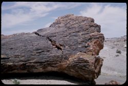
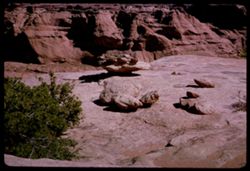
- Description:
- 25 f 10
- Subject:
- Rocks, Petrified forests, Trees, Petrified Forest National Park (Ariz.), Shrubs, Logs, Fossils, Petrified wood, and National parks & reserves
- Series:
- 17-52
- Creator:
- Cushman, Charles W., 1896-1972
- Date Created:
- 1952-04-13
- Genre:
- Identification photographs
- Frame Number:
- 16
- County:
- Apache
- Abstract:
- Base of Big tree
- Call Number:
- P06109
- Country:
- United States
- State/Province:
- Arizona
- Alternate Identifier:
- 1752.16
- Persistent URL:
- http://purl.dlib.indiana.edu/iudl/archives/cushman/P06109
-
- Description:
- 50 f 11 sl
- Subject:
- Palo verde trees, Trees, Mountains, Shrubs, Tucson Mountains (Ariz.), and Clouds
- Series:
- 8-59
- Creator:
- Cushman, Charles W., 1896-1972
- Date Created:
- 1959-02-13
- Genre:
- Landscape photographs
- Frame Number:
- 7
- County:
- Pima
- Abstract:
- Those lovely clouds above the Tucson Mtns.
- Call Number:
- P10621
- City:
- Tucson
- Country:
- United States
- State/Province:
- Arizona
- Alternate Identifier:
- 859.7
- Persistent URL:
- http://purl.dlib.indiana.edu/iudl/archives/cushman/P10621
-
- Description:
- 50 f 9
- Subject:
- National parks & reserves, Coats, Massai Point (Ariz.), Women, Shrubs, Trees, Rocks, Trails & paths, Chiricahua National Monument (Ariz.), Rock forma...
- Series:
- 4-52
- Creator:
- Cushman, Charles W., 1896-1972
- Date Created:
- 1952-01-22
- Genre:
- Portraits and Landscape photographs
- Frame Number:
- 4
- County:
- Cochise
- Persons Pictured:
- Cushman, Jean
- Abstract:
- Jean standing at side of big rocks at top of drive up mtns. of Chiricahua Nat'l Mon. MASSAI POINT
- Call Number:
- P05610
- Country:
- United States
- State/Province:
- Arizona
- Alternate Identifier:
- 452.4
- Persistent URL:
- http://purl.dlib.indiana.edu/iudl/archives/cushman/P05610
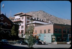
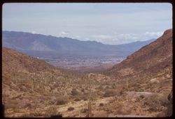
-
- Description:
- 100 f 6.3 tl
- Subject:
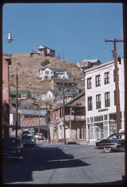
- Walls, Electric lines, Trees, Cities & towns, Shrubs, Dwellings, Hills, People, and Rocks
- Series:
- 7-59
- Creator:
- Cushman, Charles W., 1896-1972
- Date Created:
- 1959-02-06
- Genre:
- Cityscape photographs
- Frame Number:
- 32
- County:
- Cochise
- Abstract:
- Bisbee- a red hill
- Call Number:
- P10608
- City:
- Bisbee
- Country:
- United States
- State/Province:
- Arizona
- Alternate Identifier:
- 759.32
- Persistent URL:
- http://purl.dlib.indiana.edu/iudl/archives/cushman/P10608
-
- Description:
- 50 f 8 tl
- Subject:
- Valleys, Hills, Automobiles, Street lights, Dwellings, Electric lines, Buildings, Brewery Gulch (Ariz.), Signs (Notices), Streets, and Shrubs
- Series:
- 7-59
- Creator:
- Cushman, Charles W., 1896-1972
- Date Created:
- 1959-02-06
- Genre:
- Cityscape photographs
- Frame Number:
- 30
- County:
- Cochise
- Abstract:
- View up Brewery Gulch
- Call Number:
- P10606
- City:
- Bisbee
- Country:
- United States
- State/Province:
- Arizona
- Alternate Identifier:
- 759.30
- Persistent URL:
- http://purl.dlib.indiana.edu/iudl/archives/cushman/P10606
-
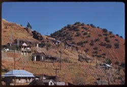
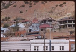
- Description:
- 100 f 6.3 tl
- Subject:
- Walls, Roads, Automobiles, Trees, Buildings, Shrubs, Dwellings, Hills, and Rocks
- Series:
- 7-59
- Creator:
- Cushman, Charles W., 1896-1972
- Date Created:
- 1959-02-06
- Genre:
- Cityscape photographs
- Frame Number:
- 34
- County:
- Cochise
- Abstract:
- Bisbee
- Call Number:
- P10610
- City:
- Bisbee
- Country:
- United States
- State/Province:
- Arizona
- Alternate Identifier:
- 759.34
- Persistent URL:
- http://purl.dlib.indiana.edu/iudl/archives/cushman/P10610
-
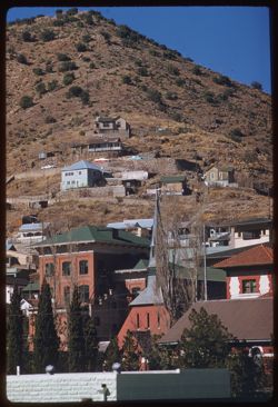
- Description:
- 100 f 6.3 tl
- Subject:
- Electric lines, Trees, Signs (Notices), Cities & towns, Buildings, Shrubs, Masonry, Dwellings, Domes, Clock towers, and Hills
- Series:
- 7-59
- Creator:
- Cushman, Charles W., 1896-1972
- Date Created:
- 1959-02-06
- Genre:
- Cityscape photographs
- Frame Number:
- 31
- County:
- Cochise
- Abstract:
- Bisbee- old dome
- Call Number:
- P10607
- City:
- Bisbee
- Country:
- United States
- State/Province:
- Arizona
- Alternate Identifier:
- 759.31
- Persistent URL:
- http://purl.dlib.indiana.edu/iudl/archives/cushman/P10607
-
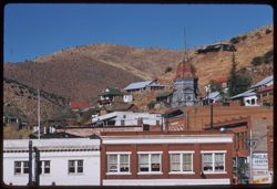
- Description:
- 100 f 6.3 tl
- Subject:
- Domes, Clock towers, Hills, Street lights, Windows, Shrubs, Electric lines, Trees, Buildings, Signs (Notices), and Dwellings
- Series:
- 7-59
- Creator:
- Cushman, Charles W., 1896-1972
- Date Created:
- 1959-02-06
- Genre:
- Cityscape photographs
- Frame Number:
- 33
- County:
- Cochise
- Call Number:
- P10609
- City:
- Bisbee
- Country:
- United States
- State/Province:
- Arizona
- Alternate Identifier:
- 759.33
- Persistent URL:
- http://purl.dlib.indiana.edu/iudl/archives/cushman/P10609
-
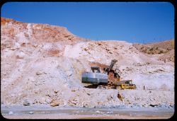
- Description:
- 50 f 8
- Subject:
- Rocks, Electric lines, Cliffs, Mining, Machinery, Mountains, Shrubs, Utility poles, Miners, Phelps Dodge Corporation, Dump trucks, and Mining equipment
- Series:
- 1-52
- Creator:
- Cushman, Charles W., 1896-1972
- Date Created:
- 1952-01-04
- Genre:
- Snapshots
- Frame Number:
- 20
- County:
- Cochise
- Abstract:
- Mining a mountainside at Lowell.
- Call Number:
- P05510
- City:
- Lowell
- Country:
- United States
- State/Province:
- Arizona
- Alternate Identifier:
- 152.20
- Persistent URL:
- http://purl.dlib.indiana.edu/iudl/archives/cushman/P05510
-
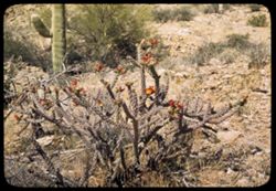
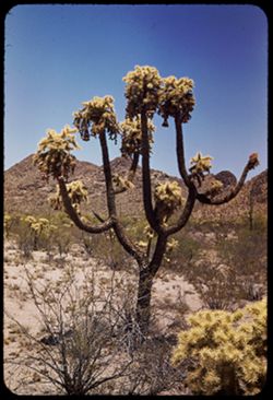
- Subject:
- Rocks, Cactus, Flowers, Shrubs, Tucson Mountains (Ariz.), and Cholla
- Series:
- 4-40
- Creator:
- Cushman, Charles W., 1896-1972
- Date Created:
- 1940-04-01
- Genre:
- Identification photographs
- Frame Number:
- 3
- County:
- Pima
- Abstract:
- Cholla in bloom . Near Gates Pass
- Call Number:
- P01791
- Country:
- United States
- State/Province:
- Arizona
- Alternate Identifier:
- 440.3
- Persistent URL:
- http://purl.dlib.indiana.edu/iudl/archives/cushman/P01791
-
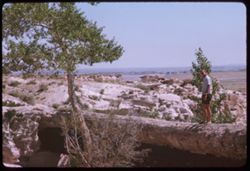
- Subject:
- Rocks, Angels Window (Ariz.), Cliffs, Trails & paths, Shadows, Shrubs, Canyons, and Cape Royal (Ariz.)
- Series:
- 12-40
- Creator:
- Cushman, Charles W., 1896-1972
- Date Created:
- 1940-07-01
- Genre:
- Views
- Frame Number:
- 21
- County:
- Coconino
- Abstract:
- Floor of Canyon from Angel's Window , Cape Royal
- Call Number:
- P01999
- Country:
- United States
- State/Province:
- Arizona
- Physical Description:
- masked. Image was originally mounted in a glass enclosure. Before digitization, the image was removed and placed in a Wess Plastic, Inc. brand, 2" x 2&q...
- Alternate Identifier:
- 1240.21
- Persistent URL:
- http://purl.dlib.indiana.edu/iudl/archives/cushman/P01999
-
- Description:
- 100 f 6.3 tl
- Subject:
- Channels, Brawley Wash (Ariz.), Roads, Mountains, Shrubs, Electric lines, and Bulls
- Series:
- 6-59
- Creator:
- Cushman, Charles W., 1896-1972
- Date Created:
- 1959-01-28
- Genre:
- Identification photographs
- Frame Number:
- 19
- Street Address:
- Sasabe Road
- County:
- Pima
- Abstract:
- One B B
- Call Number:
- P10557
- Country:
- United States
- State/Province:
- Arizona
- Alternate Identifier:
- 659.19
- Persistent URL:
- http://purl.dlib.indiana.edu/iudl/archives/cushman/P10557
-
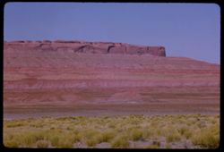
- Description:
- 50 f 10
- Subject:
- Roads, Bridges, Mountains, Shrubs, Rocks, Railings, Grasses, and Rock formations
- Series:
- 14-53
- Creator:
- Cushman, Charles W., 1896-1972
- Date Created:
- 1953-11-19
- Genre:
- Landscape photographs and Views
- Frame Number:
- 21
- Street Address:
- United States Highway 70 and United States Highway 60
- County:
- Pinal
- Abstract:
- 1936 scene
- Call Number:
- P07017
- City:
- Superior
- Country:
- United States
- State/Province:
- Arizona
- Alternate Identifier:
- 1453.21
- Persistent URL:
- http://purl.dlib.indiana.edu/iudl/archives/cushman/P07017
-
- Description:
- 50 f 9
- Subject:
- Rocks, Grasses, Buttes, Mountains, Shrubs, and Hills
- Series:
- 13-53
- Creator:
- Cushman, Charles W., 1896-1972
- Date Created:
- 1953-11-18
- Genre:
- Landscape photographs
- Frame Number:
- 23
- Street Address:
- United States Highway 70
- County:
- Graham and Greenlee
- Abstract:
- Fine mtn north of US 70 halfway between Duncan & Safford
- Call Number:
- P06980
- City:
- Duncan and Safford
- Country:
- United States
- State/Province:
- Arizona
- Alternate Identifier:
- 1353.23
- Persistent URL:
- http://purl.dlib.indiana.edu/iudl/archives/cushman/P06980
-
- Description:
- 100 f 13 TL
- Subject:
- Cliffs, Buttes, Rock formations, and Shrubs
- Series:
- 38-65
- Creator:
- Cushman, Charles W., 1896-1972
- Date Created:
- 1965-10-12
- Genre:
- Landscape photographs
- Frame Number:
- 38
- County:
- Apache
- Abstract:
- Shape near Round Rock
- Call Number:
- P15181
- City:
- Round Rock
- Country:
- United States
- State/Province:
- Arizona
- Physical Description:
- masked.
- Alternate Identifier:
- 3865.38
- Persistent URL:
- http://purl.dlib.indiana.edu/iudl/archives/cushman/P15181
-
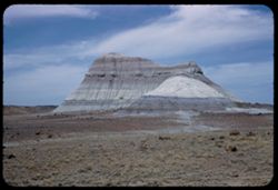
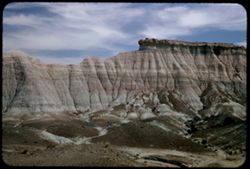
- Description:
- 100 f 13 TL
- Subject:
- Erosion, Cliffs, Mesas, Buttes, Plains, and Shrubs
- Series:
- 39-65
- Creator:
- Cushman, Charles W., 1896-1972
- Date Created:
- 1965-10-12
- Genre:
- Landscape photographs
- Frame Number:
- 1
- County:
- Apache
- Abstract:
- Butte west of Round Rock
- Call Number:
- P15182
- City:
- Round Rock
- Country:
- United States
- State/Province:
- Arizona
- Alternate Identifier:
- 3965.1
- Persistent URL:
- http://purl.dlib.indiana.edu/iudl/archives/cushman/P15182
-
- Description:
- 100 f 11 TL
- Subject:
- Erosion, Plains, Cliffs, Shrubs, Buttes, Rock formations, and Mesas
- Series:
- 39-65
- Creator:
- Cushman, Charles W., 1896-1972
- Date Created:
- 1965-10-12
- Genre:
- Landscape photographs
- Frame Number:
- 10
- County:
- Apache
- Abstract:
- Butte west of Round Rock at distance
- Call Number:
- P15191
- City:
- Round Rock
- Country:
- United States
- State/Province:
- Arizona
- Alternate Identifier:
- 3965.10
- Persistent URL:
- http://purl.dlib.indiana.edu/iudl/archives/cushman/P15191
-
- Description:
- 100 f 13 TL
- Subject:
- Cliffs, Buttes, Shrubs, Hills, and Rock formations
- Series:
- 39-65
- Creator:
- Cushman, Charles W., 1896-1972
- Date Created:
- 1965-10-12
- Genre:
- Landscape photographs
- Frame Number:
- 2
- County:
- Apache
- Abstract:
- Butte west of Round Rock
- Call Number:
- P15183
- City:
- Round Rock
- Country:
- United States
- State/Province:
- Arizona
- Alternate Identifier:
- 3965.2
- Persistent URL:
- http://purl.dlib.indiana.edu/iudl/archives/cushman/P15183
-
- Description:
- 25 f 16
- Subject:
- Petrified wood, Petrified forests, Petrified Forest National Park (Ariz.), Buttes, Shrubs, Hills, Rocks, National parks & reserves, Rock formations, and ...
- Series:
- 17-52
- Creator:
- Cushman, Charles W., 1896-1972
- Date Created:
- 1952-04-13
- Genre:
- Landscape photographs
- Frame Number:
- 32
- County:
- Apache
- Call Number:
- P06124
- Country:
- United States
- State/Province:
- Arizona
- Alternate Identifier:
- 1752.32
- Persistent URL:
- http://purl.dlib.indiana.edu/iudl/archives/cushman/P06124
-
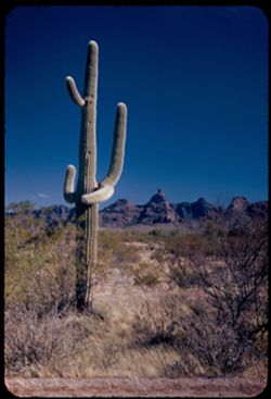
- Description:
- 25 f 6.3 Pola
- Subject:
- Organ Pipe Cactus National Monument (Ariz.), Saguaro, Mountains, Cactus, Ajo Range (Ariz.), Deserts, and Shrubs
- Series:
- 3-52
- Creator:
- Cushman, Charles W., 1896-1972
- Date Created:
- 1952-01-20
- Genre:
- Landscape photographs
- Frame Number:
- 19
- County:
- Pima
- Abstract:
- Cactus & crazy mtn. South of Ajo
- Call Number:
- P05588
- City:
- Ajo
- Country:
- United States
- State/Province:
- Arizona
- Alternate Identifier:
- 352.19
- Persistent URL:
- http://purl.dlib.indiana.edu/iudl/archives/cushman/P05588
-
- Description:
- 100 f 11 TL
- Subject:
- Tsegi Overlook (Ariz.), Canyons, Chelly, Canyon de (Ariz.), Shrubs, Mesas, and Cliffs
- Series:
- 39-65
- Creator:
- Cushman, Charles W., 1896-1972
- Date Created:
- 1965-10-12
- Genre:
- Landscape photographs
- Frame Number:
- 11
- County:
- Apache
- Abstract:
- Tsegi Overlook
- Call Number:
- P15192
- Country:
- United States
- State/Province:
- Arizona
- Alternate Identifier:
- 3965.11
- Persistent URL:
- http://purl.dlib.indiana.edu/iudl/archives/cushman/P15192
-
- Description:
- 100 f 11 TL
- Subject:
- Canyons, Cliffs, Trees, Shrubs, Mesas, and Rock formations
- Series:
- 38-65
- Creator:
- Cushman, Charles W., 1896-1972
- Date Created:
- 1965-10-11
- Genre:
- Landscape photographs
- Frame Number:
- 33
- Street Address:
- United States Highway 64
- County:
- Navajo
- Abstract:
- Canyon at Tsegi
- Call Number:
- P15176
- City:
- Tsegi
- Country:
- United States
- State/Province:
- Arizona
- Alternate Identifier:
- 3865.33
- Persistent URL:
- http://purl.dlib.indiana.edu/iudl/archives/cushman/P15176
-
- Description:
- 100 f 13 TL
- Subject:
- Canyons, Cliffs, Mesas, Shrubs, and Rock formations
- Series:
- 38-65
- Creator:
- Cushman, Charles W., 1896-1972
- Date Created:
- 1965-10-11
- Genre:
- Landscape photographs
- Frame Number:
- 32
- Street Address:
- United States Highway 64
- County:
- Navajo
- Abstract:
- Canyon at Tsegi
- Call Number:
- P15175
- City:
- Tsegi
- Country:
- United States
- State/Province:
- Arizona
- Alternate Identifier:
- 3865.32
- Persistent URL:
- http://purl.dlib.indiana.edu/iudl/archives/cushman/P15175
-
- Description:
- 100 f 11 SL
- Subject:
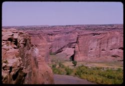
- Canyons, Junction Overlook (Ariz.), Cliffs, Boulders, Chelly, Canyon de (Ariz.), Rock formations, and Shrubs
- Series:
- 39-65
- Creator:
- Cushman, Charles W., 1896-1972
- Date Created:
- 1965-10-12
- Genre:
- Landscape photographs
- Frame Number:
- 20
- County:
- Apache
- Abstract:
- from Junction Overlook
- Call Number:
- P15201
- Country:
- United States
- State/Province:
- Arizona
- Alternate Identifier:
- 3965.20
- Persistent URL:
- http://purl.dlib.indiana.edu/iudl/archives/cushman/P15201
-
- Subject:
- Mountains, Tucson Mountains (Ariz.), Shrubs, Santa Catalina Mountains (Ariz.), Trees, and Clouds
- Series:
- 4-40
- Creator:
- Cushman, Charles W., 1896-1972
- Date Created:
- 1940-04-01
- Genre:
- Landscape photographs
- Frame Number:
- 15
- County:
- Pima
- Abstract:
- Cat Mtn. In Tucson Mtns.
- Call Number:
- P01802
- Country:
- United States
- State/Province:
- Arizona
- Physical Description:
- Image was originally mounted in a glass enclosure. Before digitization, the image was removed and placed in a Wess Plastic, Inc. brand, 2" x 2", pl...
- Alternate Identifier:
- 440.15
- Persistent URL:
- http://purl.dlib.indiana.edu/iudl/archives/cushman/P01802
-
- Description:
- 50 f 9 sl
- Subject:
- Cactus, Mountains, Shrubs, Tucson Mountains (Ariz.), Clouds, and Cat Mountain (Ariz.)
- Series:
- 6-59
- Creator:
- Cushman, Charles W., 1896-1972
- Date Created:
- 1959-02-02
- Genre:
- Landscape photographs
- Frame Number:
- 37
- County:
- Pima
- Abstract:
- Cat Mtn from S.E.
- Call Number:
- P10575
- City:
- Tucson
- Country:
- United States
- State/Province:
- Arizona
- Alternate Identifier:
- 659.37
- Persistent URL:
- http://purl.dlib.indiana.edu/iudl/archives/cushman/P10575
-
- Description:
- 50 f 8 sl
- Subject:
- Mountains, Shrubs, Tucson Mountains (Ariz.), Clouds, and Cat Mountain (Ariz.)
- Series:
- 6-59
- Creator:
- Cushman, Charles W., 1896-1972
- Date Created:
- 1959-01-28
- Genre:
- Landscape photographs
- Frame Number:
- 38
- County:
- Pima
- Abstract:
- Cat Mtn from west
- Call Number:
- P10576
- City:
- Tucson
- Country:
- United States
- State/Province:
- Arizona
- Alternate Identifier:
- 659.38
- Persistent URL:
- http://purl.dlib.indiana.edu/iudl/archives/cushman/P10576
-
- Subject:
- Rocks, Agaves, Shrubs, and Santa Catalina Mountains (Ariz.)
- Series:
- 5-40
- Creator:
- Cushman, Charles W., 1896-1972
- Date Created:
- 1940-05-01
- Genre:
- Identification photographs
- Frame Number:
- 12
- Abstract:
- Century plants in bloom. Santa Catalina Mtns.
- Call Number:
- P01830
- Country:
- United States
- State/Province:
- Arizona
- Alternate Identifier:
- 540.12
- Persistent URL:
- http://purl.dlib.indiana.edu/iudl/archives/cushman/P01830
-
- Description:
- 100 f 8 tl
- Subject:
- Altar River Valley (Mexico), Cerro Colorado Mountains (Ariz.), Mountains, and Shrubs
- Series:
- 6-59
- Creator:
- Cushman, Charles W., 1896-1972
- Date Created:
- 1959-01-28
- Genre:
- Landscape photographs
- Frame Number:
- 26
- County:
- Pima
- Abstract:
- Cerro Colorado Mtns from across Altar valley
- Call Number:
- P10564
- Country:
- United States
- State/Province:
- Arizona
- Alternate Identifier:
- 659.26
- Persistent URL:
- http://purl.dlib.indiana.edu/iudl/archives/cushman/P10564
-
- Description:
- 100 f 8 tl
- Subject:
- Cerro Colorado Mountains (Ariz.), Mountains, and Shrubs
- Series:
- 6-59
- Creator:
- Cushman, Charles W., 1896-1972
- Date Created:
- 1959-01-28
- Genre:
- Landscape photographs
- Frame Number:
- 34
- County:
- Pima
- Abstract:
- Cerro Colorado from SW farther on
- Call Number:
- P10572
- Country:
- United States
- State/Province:
- Arizona
- Alternate Identifier:
- 659.34
- Persistent URL:
- http://purl.dlib.indiana.edu/iudl/archives/cushman/P10572
-
- Description:
- 100 f 8 tl
- Subject:
- Roads, Cerro Colorado Mountains (Ariz.), Mountains, and Shrubs
- Series:
- 6-59
- Creator:
- Cushman, Charles W., 1896-1972
- Date Created:
- 1959-01-28
- Genre:
- Landscape photographs
- Frame Number:
- 33
- County:
- Pima
- Abstract:
- Cerro Colorado from SW farther on
- Call Number:
- P10571
- Country:
- United States
- State/Province:
- Arizona
- Alternate Identifier:
- 659.33
- Persistent URL:
- http://purl.dlib.indiana.edu/iudl/archives/cushman/P10571
-
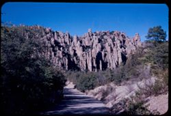
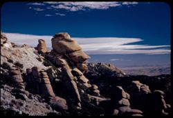
- Description:
- 25 f 11
- Subject:
- Rock formations, Trees, Chiricahua National Monument (Ariz.), Cliffs, Roads, and Shrubs
- Series:
- 3-52
- Creator:
- Cushman, Charles W., 1896-1972
- Date Created:
- 1952-01-22
- Genre:
- Landscape photographs
- Frame Number:
- 38
- County:
- Cochise
- Abstract:
- In Chiricahua National Monument
- Call Number:
- P05607
- Country:
- United States
- State/Province:
- Arizona
- Alternate Identifier:
- 352.38
- Persistent URL:
- http://purl.dlib.indiana.edu/iudl/archives/cushman/P05607
-
- Subject:
- Cactus, Flowers, Mountains, Shrubs, Clouds, Tucson Mountain Park (Ariz.), Cholla, and Ferocactus
- Series:
- 4-40
- Creator:
- Cushman, Charles W., 1896-1972
- Date Created:
- 1940-04-01
- Genre:
- Identification photographs
- Frame Number:
- 16
- County:
- Pima
- Abstract:
- Cholla in red bloom. Tucson Mtn-Park. Large blooming cholla, barrel cactuss, cursed
- Call Number:
- P01803
- Country:
- United States
- State/Province:
- Arizona
- Physical Description:
- Image was originally mounted in a glass enclosure. Before digitization, the image was removed and placed in a Wess Plastic, Inc. brand, 2" x 2", pl...
- Alternate Identifier:
- 440.16
- Persistent URL:
- http://purl.dlib.indiana.edu/iudl/archives/cushman/P01803
-
- Subject:
- Rincon Mountains (Ariz.), Trees, Flowers, Mountains, Shrubs, and Cholla
- Series:
- 4-40
- Creator:
- Cushman, Charles W., 1896-1972
- Date Created:
- 1940-04-01
- Genre:
- Landscape photographs
- Frame Number:
- 19
- County:
- Pima
- Abstract:
- Cholla, orange-colored, in Rincon Mtn. Foorhills.
- Call Number:
- P01806
- Country:
- United States
- State/Province:
- Arizona
- Physical Description:
- Image was originally mounted in a glass enclosure. Before digitization, the image was removed and placed in a Wess Plastic, Inc. brand, 2" x 2", pl...
- Alternate Identifier:
- 440.19
- Persistent URL:
- http://purl.dlib.indiana.edu/iudl/archives/cushman/P01806
-
- Description:
- 25 f 9
- Subject:
- Steeples, Churches, Windows, Dormers, Gables, Shrubs, and Trees
- Series:
- 1-52
- Creator:
- Cushman, Charles W., 1896-1972
- Date Created:
- 1952-01-04
- Genre:
- Architectural photographs
- Frame Number:
- 26
- County:
- Cochise
- Abstract:
- Church at Bisbee.
- Call Number:
- P05516
- City:
- Bisbee
- Country:
- United States
- State/Province:
- Arizona
- Alternate Identifier:
- 152.26
- Persistent URL:
- http://purl.dlib.indiana.edu/iudl/archives/cushman/P05516
-
- Description:
- 25 f 12
- Subject:
- Deserts, Cactus, Mountains, Shrubs, Saguaro, Saguaro National Park (Ariz.), and National parks & reserves
- Series:
- 3-52
- Creator:
- Cushman, Charles W., 1896-1972
- Date Created:
- 1952-01-15
- Genre:
- Identification photographs
- Frame Number:
- 14
- County:
- Pima
- Abstract:
- Close-up of a drunken Schuaro
- Call Number:
- P05583
- City:
- Tucson
- Country:
- United States
- State/Province:
- Arizona
- Alternate Identifier:
- 352.14
- Persistent URL:
- http://purl.dlib.indiana.edu/iudl/archives/cushman/P05583
-
- Description:
- 100 f 6.3 tl
- Subject:
- Fences, Mountains, Trees, Dwellings, Horses, Electric lines, Shrubs, and Cochise Head (Ariz.)
- Series:
- 5-59
- Creator:
- Cushman, Charles W., 1896-1972
- Date Created:
- 1959-01-23
- Genre:
- Landscape photographs
- Frame Number:
- 36
- Street Address:
- Arizona State Highway 86
- County:
- Cochise
- Abstract:
- Cochise Head from Ariz Hwy 86
- Call Number:
- P10537
- Country:
- United States
- State/Province:
- Arizona
- Alternate Identifier:
- 559.36
- Persistent URL:
- http://purl.dlib.indiana.edu/iudl/archives/cushman/P10537
-
- Description:
- 50 f 6.3
- Subject:
- Rocks, Boulders, Mountains, Rock formations, Clouds, Santa Catalina Mountains (Ariz.), and Shrubs
- Series:
- 4-52
- Creator:
- Cushman, Charles W., 1896-1972
- Date Created:
- 1952-01-25
- Genre:
- Landscape photographs
- Frame Number:
- 24
- Street Address:
- Mount Lemmon Road
- Abstract:
- On down road - rock like..cuirass
- Call Number:
- P05630
- Country:
- United States
- State/Province:
- Arizona
- Alternate Identifier:
- 452.24
- Persistent URL:
- http://purl.dlib.indiana.edu/iudl/archives/cushman/P05630
-
- Subject:
- Canyons, Grand Canyon (Ariz.), Shrubs, Trees, Colorado River (Colo.-Mexico), Rock formations, and Rivers
- Series:
- 13-40
- Creator:
- Cushman, Charles W., 1896-1972
- Date Created:
- 1940-07-14
- Genre:
- Landscape photographs
- Frame Number:
- 2
- Abstract:
- Colorado from South Rim. Sunday afternoon
- Call Number:
- P02001
- Country:
- United States
- State/Province:
- Arizona
- Physical Description:
- Image was originally mounted in a glass enclosure. Before digitization, the image was removed and placed in a Wess Plastic, Inc. brand, 2" x 2", pl...
- Alternate Identifier:
- 1340.2
- Persistent URL:
- http://purl.dlib.indiana.edu/iudl/archives/cushman/P02001
-
- Description:
- 25 f 9
- Subject:
- Hotels, Cities & towns, Churches, Streets, Hills, Automobiles, Street lights, Shrubs, Electric lines, Trees, Buildings, Coca-Cola Company, Signs (Notices...
- Series:
- 1-52
- Creator:
- Cushman, Charles W., 1896-1972
- Date Created:
- 1952-01-04
- Genre:
- Architectural photographs
- Frame Number:
- 27
- County:
- Cochise
- Abstract:
- Copper Queen.
- Call Number:
- P05517
- City:
- Bisbee
- Country:
- United States
- State/Province:
- Arizona
- Alternate Identifier:
- 152.27
- Persistent URL:
- http://purl.dlib.indiana.edu/iudl/archives/cushman/P05517
-
- Description:
- 25 f 11
- Subject:
- Cotton, Farms, Croplands, Shrubs, and Mountains
- Series:
- 2-52
- Creator:
- Cushman, Charles W., 1896-1972
- Date Created:
- 1952-01-11
- Genre:
- Landscape photographs
- Frame Number:
- 20
- Street Address:
- Nogales Highway
- County:
- Pima and Santa Cruz
- Abstract:
- Cotton field + mountains 15 miles no. of Nogales.
- Call Number:
- P05550
- City:
- Nogales and Tucson
- Country:
- United States
- State/Province:
- Arizona
- Alternate Identifier:
- 252.20
- Persistent URL:
- http://purl.dlib.indiana.edu/iudl/archives/cushman/P05550
-
- Subject:
- Cactus, Flowers, Mountains, Shrubs, Tucson Mountains (Ariz.), and Cholla
- Series:
- 5-40
- Creator:
- Cushman, Charles W., 1896-1972
- Date Created:
- 1940-05-01
- Genre:
- Identification photographs
- Frame Number:
- 3
- County:
- Pima
- Abstract:
- Cursed cholla-in Tucson Mtn. Foothills
- Call Number:
- P01811
- Country:
- United States
- State/Province:
- Arizona
- Alternate Identifier:
- 540.3
- Persistent URL:
- http://purl.dlib.indiana.edu/iudl/archives/cushman/P01811
-
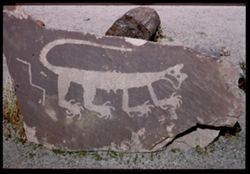
- Description:
- 25 f 11
- Subject:
- Rocks, Petrified forests, Petrified Forest National Park (Ariz.), National parks & reserves, Logs, Fossils, Petrified wood, Rock art, and Shrubs
- Series:
- 17-52
- Creator:
- Cushman, Charles W., 1896-1972
- Date Created:
- 1952-04-13
- Genre:
- Reproductions and Identification photographs
- Frame Number:
- 13
- County:
- Apache
- Abstract:
- Petroglyph-Animal
- Call Number:
- P06106
- Country:
- United States
- State/Province:
- Arizona
- Physical Description:
- Image was originally mounted in a glass enclosure. Before digitization, the image was removed and placed in a Wess Plastic, Inc. brand, 2" x 2", pl...
- Alternate Identifier:
- 1752.13
- Persistent URL:
- http://purl.dlib.indiana.edu/iudl/archives/cushman/P06106
-
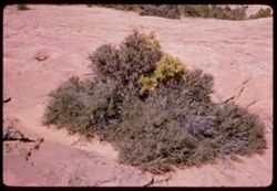
- Description:
- 50 f 11
- Subject:
- Rocks, Navajo National Monument (Ariz.), Shrubs, and National parks & reserves
- Series:
- 38-65
- Creator:
- Cushman, Charles W., 1896-1972
- Date Created:
- 1965-10-11
- Genre:
- Landscape photographs
- Frame Number:
- 27
- County:
- Navajo
- Abstract:
- Desert bush
- Call Number:
- P15170
- City:
- Kayenta
- Country:
- United States
- State/Province:
- Arizona
- Alternate Identifier:
- 3865.27
- Persistent URL:
- http://purl.dlib.indiana.edu/iudl/archives/cushman/P15170
-
- Description:
- 25 f 9 Pola
- Subject:
- Deserts, Petrified forests, Cliffs, Boulders, Petrified Forest National Park (Ariz.), National parks & reserves, Hills, Rocks, Shrubs, and Rock formations
- Series:
- 17-52
- Creator:
- Cushman, Charles W., 1896-1972
- Date Created:
- 1952-04-13
- Genre:
- Landscape photographs
- Frame Number:
- 10
- County:
- Apache and Navajo
- Abstract:
- Petrified Forest
- Call Number:
- P06103
- City:
- Holbrook
- Country:
- United States
- State/Province:
- Arizona
- Alternate Identifier:
- 1752.10
- Persistent URL:
- http://purl.dlib.indiana.edu/iudl/archives/cushman/P06103
-
- Description:
- 25 f 11 pola
- Subject:
- Petrified Forest National Park (Ariz.), National parks & reserves, Deserts, Canyons, Hills, Cliffs, Shrubs, Boulders, Rocks, Rock formations, Mesas, Petr...
- Series:
- 17-52
- Creator:
- Cushman, Charles W., 1896-1972
- Date Created:
- 1952-04-13
- Genre:
- Landscape photographs
- Frame Number:
- 36
- County:
- Apache
- Abstract:
- In Blue Forest 113737
- Call Number:
- P06128
- Country:
- United States
- State/Province:
- Arizona
- Alternate Identifier:
- 1752.36
- Persistent URL:
- http://purl.dlib.indiana.edu/iudl/archives/cushman/P06128
-
- Description:
- 100 f 5.6 tl
- Subject:
- Roads, Cactus, Mountains, Buildings, Gates Pass (Ariz.), Tucson Mountains (Ariz.), Clouds, Dwellings, Hills, Cities & towns, Shrubs, and Traffic signs &a...
- Series:
- 8-59
- Creator:
- Cushman, Charles W., 1896-1972
- Date Created:
- 1959-02-11
- Genre:
- Cityscape photographs
- Frame Number:
- 1
- County:
- Pima
- Abstract:
- Tucson seen from Gates Pass in Tucson Mtns.
- Call Number:
- P10615
- City:
- Tucson
- Country:
- United States
- State/Province:
- Arizona
- Alternate Identifier:
- 859.1
- Persistent URL:
- http://purl.dlib.indiana.edu/iudl/archives/cushman/P10615
-
- Description:
- 25 f 9 Pola
- Subject:
- Valleys, Petrified forests, Cliffs, Petrified Forest National Park (Ariz.), Rock formations, Hills, National parks & reserves, and Shrubs
- Series:
- 17-52
- Creator:
- Cushman, Charles W., 1896-1972
- Date Created:
- 1952-04-13
- Genre:
- Landscape photographs
- Frame Number:
- 11
- County:
- Apache and Navajo
- Abstract:
- Elephant Hide
- Call Number:
- P06104
- City:
- Holbrook
- Country:
- United States
- State/Province:
- Arizona
- Alternate Identifier:
- 1752.11
- Persistent URL:
- http://purl.dlib.indiana.edu/iudl/archives/cushman/P06104