
Search Constraints
You searched for:
Campus
IUB
Remove constraint Campus: IUB
Subject
Topical Subject: Soviet Union
Remove constraint Subject: Topical Subject: Soviet Union
State/Province
Калининская область (Kalinin oblast)
Remove constraint State/Province: Калининская область (Kalinin oblast)
« Previous |
1 - 20 of 165
|
Next »
Search Results
-
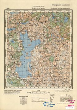
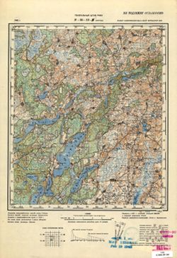
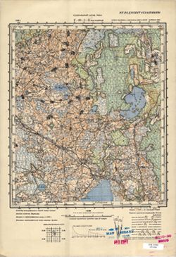
- Description:
- 1937
- Subject:
- Topical Subject: Maps, Geographic Subject: Stanislavovo, and Topical Subject: Soviet Union
- Publisher:
- Генеральный штаб РККА
- Language:
- Russian
- Identifier:
- VAC9619-004012
- Genre:
- Topographic Maps and Military Maps
- Geographic Location:
- Coordinates: 55.667, 28.5, 56, 29
- Related URL:
- Catalog URL: https://iucat.iu.edu/catalog/5020129 and Download GeoTIFF: https://drive.google.com/file/d/11U0l99uF69tvCWzqaiO5PeXCcKNvi3fE/view?usp=sharing
- Abstract:
- Modern area represented: Stanislavovo, Vitebsk oblast, Belarus
- Call Number:
- G7000 s100 .S7 sheet N-35-10
- Caption:
- Не подлежит оглашению
- City:
- Станиславово (Stanislavovo)
- Copyright Holder:
- No Copyright - United States
- Country:
- СССР (USSR)
- State/Province:
- Калининская область (Kalinin oblast), Витебская область (Vitebsk oblast), Белорусская ССР (Byelorussian Soviet Socialist Republic), and РСФСР (RSFSR)
- Physical Description:
- Scale: 1:100,000
- Persistent URL:
- http://purl.dlib.indiana.edu/iudl/images/VAC9619/VAC9619-004012
- Provenance:
- DMA Topographic Center, Army Map Service Library
-
- Description:
- 1937
- Subject:
- Geographic Subject: Klyastsitsy, Topical Subject: Maps, and Topical Subject: Soviet Union
- Publisher:
- Генеральный штаб РККА
- Language:
- Russian
- Identifier:
- VAC9619-000420
- Genre:
- Topographic Maps and Military Maps
- Geographic Location:
- Coordinates: 55.833, 28.5, 56, 28.75
- Related URL:
- Catalog URL: http://iucat.iu.edu/catalog/5020131 and Download GeoTIFF: https://drive.google.com/open?id=1qG_7FsG2f_slk9_mkoQw5bIMHLDQJb4o
- Abstract:
- Modern area represented: Klyastsitsy, Vitebsk oblast, Belarus
- Call Number:
- G7000 s50 .S68 sheet N-35-10-A
- Caption:
- Не подлежит оглашению
- City:
- Клястицы (Kliastitsy)
- Copyright Holder:
- No Copyright - United States
- Country:
- СССР (USSR)
- State/Province:
- РСФСР (RSFSR), Витебская область (Vitebsk oblast), Калининская область (Kalinin oblast), and Белорусская ССР (Byelorussian Soviet Socialist Republic)
- Physical Description:
- Scale: 1:50,000
- Persistent URL:
- http://purl.dlib.indiana.edu/iudl/images/VAC9619/VAC9619-000420
- Provenance:
- DMA Topographic Center, Army Map Service Library, OMAHA
-

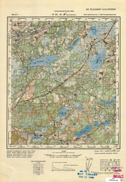
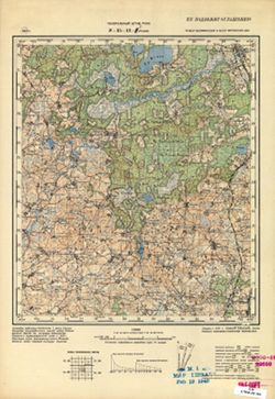
- Description:
- 1937
- Subject:
- Geographic Subject: Rasony, Topical Subject: Soviet Union, and Topical Subject: Maps
- Publisher:
- Генеральный штаб РККА
- Language:
- Russian
- Identifier:
- VAC9619-000421
- Genre:
- Topographic Maps and Military Maps
- Geographic Location:
- Coordinates: 55.833, 28.75, 56, 29
- Related URL:
- Catalog URL: http://iucat.iu.edu/catalog/5020131 and Download GeoTIFF: https://drive.google.com/open?id=1UDh7PVaAfA36BDI3q9RzDpHQrc2og3Oe
- Abstract:
- Modern area represented: Rasony, Vitebsk oblast, Belarus
- Call Number:
- G7000 s50 .S68 sheet N-35-10-B
- Caption:
- Не подлежит оглашению
- City:
- Станиславово (Stanislavovo)
- Copyright Holder:
- No Copyright - United States
- Country:
- СССР (USSR)
- State/Province:
- Калининская область (Kalinin oblast), Белорусская ССР (Byelorussian Soviet Socialist Republic), РСФСР (RSFSR), and Витебская область (Vitebsk oblast)
- Physical Description:
- Scale: 1:50,000
- Persistent URL:
- http://purl.dlib.indiana.edu/iudl/images/VAC9619/VAC9619-000421
- Provenance:
- Army Map Service Library, OMAHA, Library of Congress Geography & Map Division
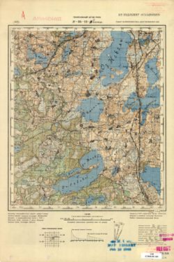
-
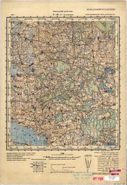
- Description:
- 1936
- Subject:
- Topical Subject: Soviet Union, Topical Subject: Maps, and Geographic Subject: Krasnapollye
- Publisher:
- Генеральный штаб РККА
- Language:
- Russian
- Date Created:
- 1937
- Identifier:
- VAC9619-004013
- Genre:
- Topographic Maps and Military Maps
- Geographic Location:
- Coordinates: 55.667, 29, 56, 29.5
- Related URL:
- Catalog URL: https://iucat.iu.edu/catalog/5020129 and Download GeoTIFF: https://drive.google.com/file/d/1ZujOSiMp81Jef6M3fdhroSY_B64ztirn/view?usp=sharing
- Abstract:
- Modern area represented: Krasnapollye, Vitebsk oblast, Belarus
- Call Number:
- G7000 s100 .S7 sheet N-35-11
- Caption:
- Не подлежит оглашению
- City:
- Краснополье (Krasnapollye)
- Copyright Holder:
- No Copyright - United States
- Country:
- СССР (USSR)
- State/Province:
- Калининская область (Kalinin oblast), Витебская область (Vitebsk oblast), Белорусская ССР (Byelorussian Soviet Socialist Republic), and РСФСР (RSFSR)
- Physical Description:
- Scale: 1:100,000
- Persistent URL:
- http://purl.dlib.indiana.edu/iudl/images/VAC9619/VAC9619-004013
- Provenance:
- DMA Topographic Center, Army Map Service Library, OMAHA, Library of Congress Geography & Map Division
-
- Description:
- 1937
- Subject:
- Topical Subject: Maps, Geographic Subject: Dvoryshcha, and Topical Subject: Soviet Union
- Publisher:
- Генеральный штаб РККА
- Language:
- Russian
- Identifier:
- VAC9619-000425
- Genre:
- Military Maps and Topographic Maps
- Geographic Location:
- Coordinates: 55.8333, 29, 56, 29.25
- Related URL:
- Catalog URL: http://iucat.iu.edu/catalog/5020131 and Download GeoTIFF: https://drive.google.com/open?id=12CH1ONXEHMp_Dt341id95ZiovrdQ3IWa
- Abstract:
- Modern area represented: Dvoryshcha, Vitebsk oblast, Belarus
- Call Number:
- G7000 s50 .S68 sheet N-35-11-A
- Caption:
- Не подлежит оглашению
- City:
- Дворище (Dvorishche)
- Copyright Holder:
- No Copyright - United States
- Country:
- СССР (USSR)
- State/Province:
- Белорусская ССР (Byelorussian Soviet Socialist Republic), Калининская область (Kalinin oblast), Витебская область (Vitebsk oblast), and РСФСР (RSFSR)
- Physical Description:
- Scale: 1:50,000
- Persistent URL:
- http://purl.dlib.indiana.edu/iudl/images/VAC9619/VAC9619-000425
- Provenance:
- M. I. Map Library, G000-30
-
- Subject:
- Geographic Subject: Krasnapolle, Topical Subject: Soviet Union, and Topical Subject: Maps
- Publisher:
- Генеральный штаб РККА
- Language:
- Russian
- Identifier:
- VAC9619-000428
- Genre:
- Topographic Maps and Military Maps
- Geographic Location:
- Coordinates: 55.6667, 29.25, 55.8333, 29.5
- Related URL:
- Catalog URL: http://iucat.iu.edu/catalog/5020131 and Download GeoTIFF: https://drive.google.com/open?id=1lnFFPfIgSAAmfNYy3K1v2DcWEbI3vPvP
- Abstract:
- Modern area represented: Krasnapolle, Vitebsk oblast, Belarus
- Call Number:
- G7000 s50 .S68 sheet N-35-11-D
- Caption:
- Не подлежит оглашению
- City:
- Краснополье (Krasnopolye)
- Copyright Holder:
- No Copyright - United States
- Country:
- СССР (USSR)
- State/Province:
- РСФСР (RSFSR), Калининская область (Kalinin oblast), Витебская область (Vitebsk oblast), and Белорусская ССР (Byelorussian Soviet Socialist Republic)
- Physical Description:
- Scale: 1:50,000
- Persistent URL:
- http://purl.dlib.indiana.edu/iudl/images/VAC9619/VAC9619-000428
- Provenance:
- M. I. Map Library, G000-30, GS, RA
-
- Description:
- 1937
- Subject:
- Geographic Subject: Yezyaryshcha, Topical Subject: Soviet Union, and Topical Subject: Maps
- Publisher:
- Генеральный штаб РККА
- Language:
- Russian
- Identifier:
- VAC9619-004014
- Genre:
- Military Maps and Topographic Maps
- Geographic Location:
- Coordinates: 55.667, 29.5, 56, 30
- Related URL:
- Catalog URL: https://iucat.iu.edu/catalog/5020129 and Download GeoTIFF: https://drive.google.com/file/d/1Ju5COfEH8_cx4PWaTKWBCvXNLXijhAiD/view?usp=sharing
- Abstract:
- Modern area represented: Yezyaryshcha, Vitebsk oblast, Belarus
- Call Number:
- G7000 s100 .S7 sheet N-35-12
- Caption:
- Не подлежит оглашению
- City:
- Езерище (Yezerishe)
- Copyright Holder:
- No Copyright - United States
- Country:
- СССР (USSR)
- State/Province:
- Белорусская ССР (Byelorussian Soviet Socialist Republic), Витебская область (Vitebsk oblast), Калининская область (Kalinin oblast), and РСФСР (RSFSR)
- Physical Description:
- Scale: 1:100,000
- Persistent URL:
- http://purl.dlib.indiana.edu/iudl/images/VAC9619/VAC9619-004014
- Provenance:
- DMA Topographic Center, Army Map Service Library, OMAHA, Library of Congress Geography & Map Division
-
- Description:
- 1937
- Subject:
- Topical Subject: Soviet Union, Topical Subject: Maps, and Geographic Subject: Yezyaryshcha
- Publisher:
- Генеральный штаб РККА
- Language:
- Russian
- Identifier:
- VAC9619-004015
- Genre:
- Topographic Maps and Military Maps
- Geographic Location:
- Coordinates: 55.667, 29.5, 56, 30
- Related URL:
- Download GeoTIFF: https://drive.google.com/file/d/18c6_uwAVXM3sK2KmH_i1KniTGwg85m2-/view?usp=sharing and Catalog URL: https://iucat.iu.edu/catalog/5020129
- Abstract:
- Modern area represented: Yezyaryshcha, Vitebsk oblast, Belarus
- Call Number:
- G7000 s100 .S7 sheet N-35-12
- Caption:
- Не подлежит оглашению
- City:
- Езерище (Yezerishe)
- Copyright Holder:
- No Copyright - United States
- Country:
- СССР (USSR)
- State/Province:
- Белорусская ССР (Byelorussian Soviet Socialist Republic), РСФСР (RSFSR), Калининская область (Kalinin oblast), and Витебская область (Vitebsk oblast)
- Physical Description:
- Scale: 1:100,000
- Persistent URL:
- http://purl.dlib.indiana.edu/iudl/images/VAC9619/VAC9619-004015
- Provenance:
- DMA Topographic Center, Army Map Service Library
-
- Description:
- 1937
- Subject:
- Topical Subject: Maps, Geographic Subject: Jeziaryshcha, and Topical Subject: Soviet Union
- Publisher:
- Генеральный штаб РККА
- Language:
- Russian
- Identifier:
- VAC9619-000431
- Genre:
- Military Maps and Topographic Maps
- Geographic Location:
- Coordinates: 55.8333, 29.75, 56, 30
- Related URL:
- https://drive.google.com/file/d/1mPSwhWa001XEhS6idD5HYHATqrkblV9s/view?usp=sharing, Download GeoTIFF: https://drive.google.com/file/d/1cV_6oJpRF6DMO3fWnieBK2...
- Abstract:
- Modern area represented: Jeziaryshcha, Vitebsk oblast, Belarus
- Call Number:
- G7000 s50 .S68 sheet N-35-12-B
- Caption:
- Не подлежит оглашению
- City:
- Езерище (Yezerishche)
- Copyright Holder:
- No Copyright - United States
- Country:
- СССР (USSR)
- State/Province:
- Витебская область (Vitebsk oblast), Белорусская ССР (Byelorussian Soviet Socialist Republic), Калининская область (Kalinin oblast), and РСФСР (RSFSR)
- Physical Description:
- Scale: 1:50,000
- Persistent URL:
- http://purl.dlib.indiana.edu/iudl/images/VAC9619/VAC9619-000431
- Provenance:
- M. I. Map Library, Heeresplankammer Gruppe Archive Auslandskartenarchiv, GS, RA, G000-30, Atlasblatt
-
- Description:
- 1937
- Subject:
- Geographic Subject: Vypush, Topical Subject: Soviet Union, and Topical Subject: Maps
- Publisher:
- Генеральный штаб РККА
- Language:
- Russian
- Identifier:
- VAC9619-000432
- Genre:
- Topographic Maps and Military Maps
- Geographic Location:
- Coordinates: 55.6667, 29.5, 55.8333, 29.75
- Related URL:
- Catalog URL: http://iucat.iu.edu/catalog/5020131 and Download GeoTIFF: https://drive.google.com/open?id=1SLX1MIVRQSAGqoHdUivrMkMO70pMHy7r
- Abstract:
- Modern area represented: abandoned populated place Vypush, Vitebsk oblast, Belarus
- Call Number:
- G7000 s50 .S68 sheet N-35-12-C
- Caption:
- Не подлежит оглашению
- City:
- Выпуш (Vypush)
- Copyright Holder:
- No Copyright - United States
- Country:
- СССР (USSR)
- State/Province:
- Белорусская ССР (Byelorussian Soviet Socialist Republic), РСФСР (RSFSR), Витебская область (Vitebsk oblast), and Калининская область (Kalinin oblast)
- Physical Description:
- Scale: 1:50,000
- Persistent URL:
- http://purl.dlib.indiana.edu/iudl/images/VAC9619/VAC9619-000432
- Provenance:
- M. I. Map Library, Reichsamt für Landesaufnahme, Kartensammlung, GS, RA, G000-30
-
- Description:
- 1937
- Subject:
- Topical Subject: Soviet Union, Topical Subject: Maps, and Geographic Subject: Rudnya
- Publisher:
- Генеральный штаб РККА
- Language:
- Russian
- Identifier:
- VAC9619-000433
- Genre:
- Military Maps and Topographic Maps
- Geographic Location:
- Coordinates: 55.6667, 29.75, 55.8333, 30
- Related URL:
- Download GeoTIFF: https://drive.google.com/open?id=1pjBbMvMADu6X1fhFqKNsAViSBd9R1ZK8 and Catalog URL: http://iucat.iu.edu/catalog/5020131
- Abstract:
- Modern area represented: abandoned populated place Rudnya, Vitebskaya oblast, Belarus
- Call Number:
- G7000 s50 .S68 sheet N-35-12-D
- Caption:
- Не подлежит оглашению
- City:
- Рудня (Rudnya)
- Copyright Holder:
- No Copyright - United States
- Country:
- СССР (USSR)
- State/Province:
- РСФСР (RSFSR), Белорусская ССР (Byelorussian Soviet Socialist Republic), Витебская область (Vitebsk oblast), and Калининская область (Kalinin oblast)
- Physical Description:
- Scale: 1:50,000
- Persistent URL:
- http://purl.dlib.indiana.edu/iudl/images/VAC9619/VAC9619-000433
- Provenance:
- M. I. Map Library, G000-30
-
- Description:
- 1937
- Subject:
- Geographic Subject: Mezha, Topical Subject: Soviet Union, and Topical Subject: Maps
- Publisher:
- Генеральный штаб РККА
- Language:
- Russian
- Date Created:
- 1938
- Identifier:
- VAC9619-004146
- Genre:
- Topographic Maps and Military Maps
- Geographic Location:
- Coordinates: 55.667, 30, 56, 30.5
- Related URL:
- Download GeoTIFF: https://drive.google.com/file/d/1Z80Upxi8vcMagHwiWr3iAR2KODpabbk9/view?usp=sharing and Catalog URL: https://iucat.iu.edu/catalog/5020129
- Abstract:
- Modern area represented: Mezha, Russia
- Call Number:
- G7000 s100 .S7 sheet N-36-1
- Caption:
- Не подлежит оглашению
- City:
- Межа (Mezha)
- Copyright Holder:
- No Copyright - United States
- Country:
- СССР (USSR)
- State/Province:
- Белорусская ССР (Byelorussian Soviet Socialist Republic), Калининская область (Kalinin oblast), Смоленская область (Smolensk oblast), РСФСР (RSFSR), and Вите...
- Physical Description:
- Scale: 1:100,000
- Persistent URL:
- http://purl.dlib.indiana.edu/iudl/images/VAC9619/VAC9619-004146
- Provenance:
- DMA Topographic Center, Army Map Service Library, OMAHA
-
- Description:
- 1937
- Subject:
- Geographic Subject: Koshelevo, Topical Subject: Soviet Union, and Topical Subject: Maps
- Publisher:
- Генеральный штаб РККА
- Language:
- Russian
- Identifier:
- VAC9619-001180
- Genre:
- Topographic Maps and Military Maps
- Geographic Location:
- Coordinates: 55.8333, 30, 56, 30.25
- Related URL:
- Catalog URL: http://iucat.iu.edu/catalog/5020131 and Download GeoTIFF: https://drive.google.com/open?id=1fvQPflRZMi0_C7WOT511XnuTxVOZrbYm
- Abstract:
- Modern area represented: Koshelevo, Russia
- Call Number:
- GM G7000 S50 .S68 N-36-1-A
- Caption:
- Не подлежит оглашению
- City:
- Кошелево (Koshelevo)
- Copyright Holder:
- No Copyright - United States
- Country:
- СССР (USSR)
- State/Province:
- Витебская область (Vitebsk oblast), РСФСР (RSFSR), Калининская область (Kalinin oblast), and Белорусская ССР (Byelorussian Soviet Socialist Republic)
- Physical Description:
- Scale: 1:50,000
- Persistent URL:
- http://purl.dlib.indiana.edu/iudl/images/VAC9619/VAC9619-001180
- Provenance:
- M. I. Map Library, G000-30
-
- Description:
- 1937
- Subject:
- Topical Subject: Maps, Geographic Subject: Bolshaya Budnitsa, and Topical Subject: Soviet Union
- Publisher:
- Генеральный штаб РККА
- Language:
- Russian
- Identifier:
- VAC9619-001181
- Genre:
- Topographic Maps and Military Maps
- Geographic Location:
- Coordinates: 55.8333, 30.25, 56, 30.5
- Related URL:
- Download GeoTIFF: https://drive.google.com/open?id=1cloBA9T45spXH6I5DTUJSE1CtybxFlWa and Catalog URL: http://iucat.iu.edu/catalog/5020131
- Abstract:
- Modern area represented: Bolshaya Budnitsa, Pskov oblast, Russia
- Call Number:
- GM G7000 S50 .S68 N-36-1-Б
- Caption:
- Не подлежит оглашению
- City:
- Бол. Будница (Bolshaya Budnitsa)
- Copyright Holder:
- No Copyright - United States
- Country:
- СССР (USSR)
- State/Province:
- Калининская область (Kalinin oblast), Смоленская область (Smolensk oblast), Витебская область (Vitebsk oblast), РСФСР (RSFSR), and Белорусская ССР (Byeloruss...
- Physical Description:
- Scale: 1:50,000
- Persistent URL:
- http://purl.dlib.indiana.edu/iudl/images/VAC9619/VAC9619-001181
- Provenance:
- M. I. Map Library, G000-30
-

- Description:
- 1939
- Subject:
- Topical Subject: Soviet Union, Geographic Subject: Karmanovo, and Topical Subject: Maps
- Publisher:
- Генеральный штаб Красной Армии
- Language:
- Russian
- Date Created:
- 1941
- Identifier:
- VAC9619-004150
- Genre:
- Topographic Maps and Military Maps
- Geographic Location:
- Coordinates: 55.667, 34.5, 56, 35
- Related URL:
- Download GeoTIFF: https://drive.google.com/file/d/1gODnEnCNkJ7LsHO8wwP5guFmkhqszNsR/view?usp=sharing and Catalog URL: https://iucat.iu.edu/catalog/5020129
- Abstract:
- Modern area represented: Karmanovo, Russia
- Call Number:
- G7000 s100 .S7 sheet N-36-10
- City:
- Карманово (Karmanovo)
- Copyright Holder:
- No Copyright - United States
- Country:
- СССР (USSR)
- State/Province:
- РСФСР (RSFSR), Калининская область (Kalinin oblast), and Смоленская область (Smolensk oblast)
- Physical Description:
- Scale: 1:100,000
- Persistent URL:
- http://purl.dlib.indiana.edu/iudl/images/VAC9619/VAC9619-004150
- Provenance:
- DMA Topographic Center, Army Map Service Library, OMAHA
-
- Description:
- 1939
- Subject:
- Geographic Subject: Khrenovaya, Topical Subject: Soviet Union, and Topical Subject: Maps
- Publisher:
- Главное Управление Геодезии и Картографии при СНК СССР
- Language:
- Russian
- Identifier:
- VAC9619-001211
- Genre:
- Topographic Maps and Military Maps
- Geographic Location:
- Coordinates: 55.8333, 34.5, 56, 34.75
- Related URL:
- Download GeoTIFF: https://drive.google.com/open?id=1k8U08OQuEFaqGZ2G0RysTK7KOBM0ITxc and Catalog URL: http://iucat.iu.edu/catalog/5020131
- Abstract:
- Modern area represented: Khrenovaya, Smolensk oblast, Russia
- Call Number:
- GM G7000 S50 .S68 N-36-10-A
- Copyright Holder:
- No Copyright - United States
- Country:
- СССР (USSR)
- State/Province:
- Калининская область (Kalinin oblast), РСФСР (RSFSR), and Смоленская область (Smolensk oblast)
- Physical Description:
- Scale: 1:50,000
- Persistent URL:
- http://purl.dlib.indiana.edu/iudl/images/VAC9619/VAC9619-001211
- Provenance:
- DMA Topographic Center, Army Map Service Library, OMAHA, Library of Congress Geography & Map Division
-
- Description:
- 1939
- Subject:
- Geographic Subject: Shtanino, Topical Subject: Soviet Union, and Topical Subject: Maps
- Publisher:
- Главное Управление Геодезии и Картографии при СНК СССР
- Language:
- Russian
- Identifier:
- VAC9619-001212
- Genre:
- Topographic Maps and Military Maps
- Geographic Location:
- Coordinates: 55.8333, 34.75, 56, 35
- Related URL:
- Download GeoTIFF: https://drive.google.com/open?id=1y5X1GYl8HGWIanxXxjS5msI6NV-Zj2X_ and Catalog URL: http://iucat.iu.edu/catalog/5020131
- Abstract:
- Modern area represented: Shtanino, Smolensk oblast, Russia
- Call Number:
- GM G7000 S50 .S68 N-36-10-Б
- Copyright Holder:
- No Copyright - United States
- Country:
- СССР (USSR)
- State/Province:
- РСФСР (RSFSR), Калининская область (Kalinin oblast), and Смоленская область (Smolensk oblast)
- Physical Description:
- Scale: 1:50,000
- Persistent URL:
- http://purl.dlib.indiana.edu/iudl/images/VAC9619/VAC9619-001212
- Provenance:
- DMA Topographic Center, Army Map Service Library, OMAHA, Library of Congress Geography & Map Division
-
- Description:
- 1926
- Subject:
- Geographic Subject: Usvyata, Topical Subject: Maps, and Topical Subject: Soviet Union
- Publisher:
- Генеральный штаб Красной Армии
- Language:
- Russian
- Identifier:
- VAC9619-004147
- Genre:
- Military Maps and Topographic Maps
- Geographic Location:
- Coordinates: 55.667, 30.5, 56, 31
- Related URL:
- Download GeoTIFF: https://drive.google.com/file/d/1FQIHqM8iEsP9maNdGgLIHqE7Lx8tm4zR/view?usp=sharing and Catalog URL: https://iucat.iu.edu/catalog/5020129
- Abstract:
- Modern area represented: Usvyata, Pskov oblast, Russia
- Call Number:
- G7000 s100 .S7 sheet N-36-2
- Caption:
- Для служебного пользования
- City:
- Усвяты (Usvyata)
- Copyright Holder:
- No Copyright - United States
- Country:
- СССР (USSR)
- State/Province:
- Белорусская ССР (Byelorussian Soviet Socialist Republic), Калининская область (Kalinin oblast), Витебская область (Vitebsk oblast), РСФСР (RSFSR), and Смолен...
- Physical Description:
- Scale: 1:100,000
- Persistent URL:
- http://purl.dlib.indiana.edu/iudl/images/VAC9619/VAC9619-004147
- Provenance:
- DMA Topographic Center, Army Map Service Library, OMAHA
-
- Description:
- 1926
- Subject:
- Topical Subject: Soviet Union, Topical Subject: Maps, and Geographic Subject: Kresty
- Publisher:
- Генеральный штаб Красной Армии
- Language:
- Russian
- Date Created:
- 1941
- Identifier:
- VAC9619-004148
- Genre:
- Topographic Maps and Military Maps
- Geographic Location:
- Coordinates: 55.667, 31, 56, 31.5
- Related URL:
- Catalog URL: https://iucat.iu.edu/catalog/5020129 and Download GeoTIFF: https://drive.google.com/file/d/1DBOiHyZrBWh8V8I6P5E7INGYfjeJLG6s/view?usp=sharing
- Abstract:
- Modern area represented: Kresty, Russia
- Call Number:
- G7000 s100 .S7 sheet N-36-3
- Caption:
- Для служебного пользования
- City:
- Кресты (Kresty)
- Copyright Holder:
- No Copyright - United States
- Country:
- СССР (USSR)
- State/Province:
- Калининская область (Kalinin oblast), Смоленская область (Smolensk oblast), and РСФСР (RSFSR)
- Physical Description:
- Scale: 1:100,000
- Persistent URL:
- http://purl.dlib.indiana.edu/iudl/images/VAC9619/VAC9619-004148
- Provenance:
- DMA Topographic Center, Army Map Service Library, OMAHA
-
- Subject:
- Topical Subject: Maps, Topical Subject: Soviet Union, and Geographic Subject: Yegorye
- Publisher:
- Генеральный штаб Красной Армии
- Language:
- Russian
- Date Created:
- 1941
- Identifier:
- VAC9619-003060
- Genre:
- Military Maps and Topographic Maps
- Geographic Location:
- Coordinates: 55.667, 33, 56, 33.5
- Related URL:
- Catalog URL: https://iucat.iu.edu/catalog/5020129 and Download GeoTIFF: https://drive.google.com/file/d/1gt8xpdmzh68_peTcl-qX2jhYC26ZFJy_/view?usp=sharing
- Abstract:
- Modern area represented: Yegorye, Tver oblast, Russia
- Call Number:
- G7000 s100 .S7 sheet N-36-7
- Caption:
- Captured map
- City:
- Егорье (Yegorye)
- Copyright Holder:
- No Copyright - United States
- Country:
- СССР (USSR)
- State/Province:
- Смоленская область (Smolensk oblast), Калининская область (Kalinin oblast), and РСФСР (RSFSR)
- Physical Description:
- Scale: 1:100,000
- Persistent URL:
- http://purl.dlib.indiana.edu/iudl/images/VAC9619/VAC9619-003060
- Provenance:
- DMA Topographic Center, Army Map Service Library, OMAHA, Heeresplankammer Auslandskartenarchiv
