
Search Constraints
You searched for:
Country
Область государственных интересов Германии (Region of German state interest)
Remove constraint Country: Область государственных интересов Германии (Region of German state interest)
Date Created
1941
Remove constraint Date Created: 1941
Pages
0-99 pages
Remove constraint Pages: 0-99 pages
« Previous |
1 - 20 of 91
|
Next »
Search Results
-
- Subject:
- Topical Subject: Maps, Geographic Subject: Dubowo Pierwsze, and Topical Subject: Soviet Union
- Publisher:
- Генеральный штаб Красной Армии
- Language:
- Russian
- Date Created:
- 1941
- Identifier:
- VAC9619-003826
- Genre:
- Topographic Maps and Military Maps
- Geographic Location:
- Coordinates: 54, 22.875, 54.083, 23
- Related URL:
- Download GeoTIFF: https://drive.google.com/file/d/14r-fQyH7mOY4p-2FsBrew0kTqdalqLS9/view?usp=sharing and Catalog URL: https://iucat.iu.edu/catalog/14701157
- Abstract:
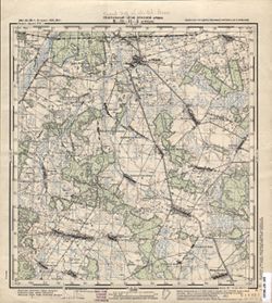
- Modern area represented: Dubowo Pierwsze, Poland
- Call Number:
- G7063.K2 s25 .S6 sheet N-34-70-D-d
- City:
- Дубово 1-ое (Dubowo Pierwsze)
- Copyright Holder:
- No Copyright - United States
- Country:
- Область государственных интересов Германии (Region of German state interest)
- Physical Description:
- Scale: 1:25,000
- Persistent URL:
- http://purl.dlib.indiana.edu/iudl/images/VAC9619/VAC9619-003826
- Provenance:
- Army Map Service Library, OMAHA, Library of Congress Geography & Map Division
-
- Subject:
- Geographic Subject: Bakaniuk, Topical Subject: Maps, and Topical Subject: Soviet Union
- Publisher:
- Генеральный штаб Красной Армии
- Language:
- Russian
- Date Created:
- 1941
- Identifier:
- VAC9619-003825
- Genre:
- Military Maps and Topographic Maps
- Geographic Location:
- Coordinates: 54, 22.75, 54.083, 22.875
- Related URL:
- Download GeoTIFF: https://drive.google.com/file/d/1xrp9zpQVNPo6Yk3_6uuukgaLUlWAn_hf/view?usp=sharing and Catalog URL: https://iucat.iu.edu/catalog/14701157
- Abstract:
- Modern area represented: Bakaniuk, Poland
- Call Number:
- G7063.K2 s25 .S6 sheet N-34-70-D-b
- City:
- Баканюк (Bakaniuk)
- Copyright Holder:
- No Copyright - United States
- Country:
- Область государственных интересов Германии (Region of German state interest)
- Physical Description:
- Scale: 1:25,000
- Persistent URL:
- http://purl.dlib.indiana.edu/iudl/images/VAC9619/VAC9619-003825
- Provenance:
- Army Map Service Library, Library of Congress Geography & Map Division
-
- Subject:
- Topical Subject: Maps, Geographic Subject: Suwałki, and Topical Subject: Soviet Union
- Publisher:
- Генеральный штаб Красной Армии
- Language:
- Russian
- Date Created:
- 1941
- Identifier:
- VAC9619-003824
- Genre:
- Topographic Maps and Military Maps
- Geographic Location:
- Coordinates: 54.083, 22.875, 54.167, 23
- Related URL:
- Download GeoTIFF: https://drive.google.com/file/d/19dVJ3F5H_AziY1NXhM1Qg4ANEdqxp6P6/view?usp=sharing and Catalog URL: https://iucat.iu.edu/catalog/14701157
- Abstract:
- Modern area represented: Suwałki, Poland
- Call Number:
- G7063.K2 s25 .S6 sheet N-34-70-D-b
- City:
- Сувалки (Suwałki)
- Copyright Holder:
- No Copyright - United States
- Country:
- Область государственных интересов Германии (Region of German state interest)
- Physical Description:
- Scale: 1:25,000
- Persistent URL:
- http://purl.dlib.indiana.edu/iudl/images/VAC9619/VAC9619-003824
- Provenance:
- Army Map Service Library, Library of Congress Geography & Map Division
-
- Subject:
- Geographic Subject: Jeleniewo, Topical Subject: Soviet Union, and Topical Subject: Maps
- Publisher:
- Генеральный штаб Красной Армии
- Language:
- Russian
- Date Created:
- 1941
- Identifier:
- VAC9619-003823
- Genre:
- Topographic Maps and Military Maps
- Geographic Location:
- Coordinates: 54.167, 22.875, 54.25, 23
- Related URL:
- Catalog URL: https://iucat.iu.edu/catalog/14701157 and Download GeoTIFF: https://drive.google.com/file/d/1IEXOWeBs29cvuQxpP53jjDmEVm_UF20C/view?usp=sharing
- Abstract:
- Modern area represented: Jeleniewo, Poland
- Call Number:
- G7063.K2 s25 .S6 sheet N-34-70-B-d
- City:
- Еленево (Jeleniewo)
- Copyright Holder:
- No Copyright - United States
- Country:
- Область государственных интересов Германии (Region of German state interest)
- Physical Description:
- Scale: 1:25,000
- Persistent URL:
- http://purl.dlib.indiana.edu/iudl/images/VAC9619/VAC9619-003823
- Provenance:
- Army Map Service Library, OMAHA, Library of Congress Geography & Map Division
-
- Subject:
- Topical Subject: Maps, Topical Subject: Soviet Union, and Geographic Subject: Pawłówka
- Publisher:
- Генеральный штаб Красной Армии
- Language:
- Russian
- Date Created:
- 1941
- Identifier:
- VAC9619-003822
- Genre:
- Military Maps and Topographic Maps
- Geographic Location:
- Coordinates: 54.167, 22.75, 54.25, 22.875
- Related URL:
- Catalog URL: https://iucat.iu.edu/catalog/14701157 and Download GeoTIFF: https://drive.google.com/file/d/1WRVcmyICQCx4nadbxhYZPXA6F1g-zvXj/view?usp=sharing
- Abstract:
- Modern area represented: Nowa Pawłówka and Stara Pawłówka, Poland
- Call Number:
- G7063.K2 s25 .S6 sheet N-34-70-B-c
- City:
- Павлувка (Pawłówka)
- Copyright Holder:
- No Copyright - United States
- Country:
- Область государственных интересов Германии (Region of German state interest)
- Physical Description:
- Scale: 1:25,000
- Persistent URL:
- http://purl.dlib.indiana.edu/iudl/images/VAC9619/VAC9619-003822
- Provenance:
- Army Map Service Library, OMAHA, Library of Congress Geography & Map Division
-
- Subject:
- Topical Subject: Maps, Topical Subject: Soviet Union, and Geographic Subject: Jałowo
- Publisher:
- Генеральный штаб Красной Армии
- Language:
- Russian
- Date Created:
- 1941
- Identifier:
- VAC9619-003821
- Genre:
- Military Maps and Topographic Maps
- Geographic Location:
- Coordinates: 54.25, 22.875, 54.333, 23
- Related URL:
- Download GeoTIFF: https://drive.google.com/file/d/1GBaO0vMThg3_tdSZzuUftYilS4-ltNo6/view?usp=sharing and Catalog URL: https://iucat.iu.edu/catalog/14701157
- Abstract:
- Modern area represented: Jałowo, Poland
- Call Number:
- G7063.K2 s25 .S6 sheet N-34-70-B-b
- City:
- Ялово (Jałowo)
- Copyright Holder:
- No Copyright - United States
- Country:
- Область государственных интересов Германии (Region of German state interest)
- Physical Description:
- Scale: 1:25,000
- Persistent URL:
- http://purl.dlib.indiana.edu/iudl/images/VAC9619/VAC9619-003821
- Provenance:
- DMA Topographic Center, Army Map Service Library, Library of Congress Geography & Map Division
-
- Subject:
- Geographic Subject: Hańcza, Topical Subject: Soviet Union, and Topical Subject: Maps
- Publisher:
- Генеральный штаб Красной Армии
- Language:
- Russian
- Date Created:
- 1941
- Identifier:
- VAC9619-003820
- Genre:
- Military Maps and Topographic Maps
- Geographic Location:
- Coordinates: 54.25, 22.75, 54.333, 22.875
- Related URL:
- Download GeoTIFF: https://drive.google.com/file/d/1th8Iaf_12VIyaDIU0NaPb09nIh7q0PuH/view?usp=sharing and Catalog URL: https://iucat.iu.edu/catalog/14701157
- Abstract:
- Modern area represented: Hańcza, Poland
- Call Number:
- G7063.K2 s25 .S6 sheet N-34-70-B-а
- City:
- Ганьча (Hańcza)
- Copyright Holder:
- No Copyright - United States
- Country:
- Область государственных интересов Германии (Region of German state interest) and Германия (Восточная Пруссия) (Germany (East Prussia))
- Physical Description:
- Scale: 1:25,000
- Persistent URL:
- http://purl.dlib.indiana.edu/iudl/images/VAC9619/VAC9619-003820
- Provenance:
- Army Map Service Library, OMAHA, Library of Congress Geography & Map Division
-
- Subject:
- Geographic Subject: Filipów, Topical Subject: Maps, and Topical Subject: Soviet Union
- Publisher:
- Генеральный штаб Красной Армии
- Language:
- Russian
- Date Created:
- 1941
- Identifier:
- VAC9619-003819
- Genre:
- Military Maps and Topographic Maps
- Geographic Location:
- Coordinates: 54.167, 22.5, 54.25, 22.625
- Related URL:
- Catalog URL: https://iucat.iu.edu/catalog/14701157 and Download GeoTIFF: https://drive.google.com/file/d/1ILUQo4m31FibY21pBMZLAlj5SkpI7Y4W/view?usp=sharing
- Abstract:
- Modern area represented: Filipów, Poland
- Call Number:
- G7063.K2 s25 .S6 sheet N-34-70-A-c
- City:
- Филипув (Filipów)
- Copyright Holder:
- No Copyright - United States
- Country:
- Германия (Восточная Пруссия) (Germany (East Prussia)) and Область государственных интересов Германии (Region of German state interest)
- Physical Description:
- Scale: 1:25,000
- Persistent URL:
- http://purl.dlib.indiana.edu/iudl/images/VAC9619/VAC9619-003819
- Provenance:
- Army Map Service Library, Library of Congress Geography & Map Division
-
- Subject:
- Topical Subject: Maps, Geographic Subject: Dubeninki, and Topical Subject: Soviet Union
- Publisher:
- Генеральный штаб Красной Армии
- Language:
- Russian
- Date Created:
- 1941
- Identifier:
- VAC9619-003818
- Genre:
- Topographic Maps and Military Maps
- Geographic Location:
- Coordinates: 54.25, 22.5, 54.333, 22.625
- Related URL:
- Catalog URL: https://iucat.iu.edu/catalog/14701157 and Download GeoTIFF: https://drive.google.com/file/d/19AcnhuhWm1XPNSHbDJOLdHiW_ecq-eVm/view?usp=sharing
- Abstract:
- Modern area represented: Dubeninki, Poland
- Call Number:
- G7063.K2 s25 .S6 sheet N-34-70-A-а
- City:
- Дубенингкен (Dubeningken)
- Copyright Holder:
- No Copyright - United States
- Country:
- Область государственных интересов Германии (Region of German state interest) and Германия (Восточная Пруссия) (Germany (East Prussia))
- Physical Description:
- Scale: 1:25,000
- Persistent URL:
- http://purl.dlib.indiana.edu/iudl/images/VAC9619/VAC9619-003818
- Provenance:
- Army Map Service Library, OMAHA, Library of Congress Geography & Map Division
-

- Subject:
- Topical Subject: Soviet Union, Geographic Subject: Leszkowice, and Topical Subject: Maps
- Publisher:
- Генеральный штаб Красной Армии
- Language:
- Russian
- Date Created:
- 1941
- Identifier:
- VAC9619-002639
- Genre:
- Topographic Maps and Military Maps
- Geographic Location:
- Coordinates: 51.5, 22.5, 51.667, 22.75
- Related URL:
- Download GeoTIFF: https://drive.google.com/file/d/1zxluSGJ01FtlvAWFM_egGfRn0kedbyCP/view?usp=sharing and Catalog URL: http://iucat.iu.edu/catalog/5020131
- Abstract:
- Modern area represented: Лешковице (Leszkowice), Poland
- Call Number:
- GM G7000 s50 .S68 sheet M-34-22-A
- City:
- Лешковице (Leszkowice)
- Copyright Holder:
- No Copyright - United States
- Country:
- Область государственных интересов Германии (Region of German state interest)
- Physical Description:
- Scale: 1:50,000
- Persistent URL:
- http://purl.dlib.indiana.edu/iudl/images/VAC9619/VAC9619-002639
- Provenance:
- DMA Topographic Center, Army Map Service Library, OMAHA, Library of Congress Geography & Map Division
-
- Subject:
- Topical Subject: Maps, Topical Subject: Soviet Union, and Geographic Subject: Leszkowice
- Publisher:
- Генеральный штаб РККА
- Language:
- Russian
- Date Created:
- 1941
- Identifier:
- VAC9619-002638
- Genre:
- Topographic Maps and Military Maps
- Geographic Location:
- Coordinates: 51.5, 22.5, 51.667, 22.75
- Related URL:
- Catalog URL: http://iucat.iu.edu/catalog/5020131 and Download GeoTIFF: https://drive.google.com/file/d/1-ru48E4UYDJBvNku10aWjihr3PA6Tj6i/view?usp=sharing
- Abstract:
- Modern area represented: Leszkowice, Poland
- Call Number:
- GM G7000 s50 .S68 sheet M-34-22-A
- City:
- Лешковице (Leszkowice)
- Copyright Holder:
- No Copyright - United States
- Country:
- Область государственных интересов Германии (Region of German state interest)
- Physical Description:
- Scale: 1:50,000
- Persistent URL:
- http://purl.dlib.indiana.edu/iudl/images/VAC9619/VAC9619-002638
-
- Subject:
- Topical Subject: Maps, Topical Subject: Soviet Union, and Geographic Subject: Holeszów
- Publisher:
- Генеральный штаб Красной Армии
- Language:
- Russian
- Date Created:
- 1941
- Identifier:
- VAC9619-002637
- Genre:
- Topographic Maps and Military Maps
- Geographic Location:
- Coordinates: 51.667, 23.25, 51.833, 23.5
- Related URL:
- Download GeoTIFF: https://drive.google.com/file/d/1i3ZkibMdOa8Ml_mse338jgWFNAv3twmg/view?usp=sharing and Catalog URL: http://iucat.iu.edu/catalog/5020131
- Abstract:
- Modern area represented: Голешув (Holeszów), Poland
- Call Number:
- GM G7000 s50 .S68 sheet M-34-11-D
- City:
- Голешув (Holeszów)
- Copyright Holder:
- No Copyright - United States
- Country:
- Область государственных интересов Германии (Region of German state interest)
- Physical Description:
- Scale: 1:50,000
- Persistent URL:
- http://purl.dlib.indiana.edu/iudl/images/VAC9619/VAC9619-002637
- Provenance:
- DMA Topographic Center, Army Map Service Library, OMAHA, Library of Congress Geography & Map Division
-
- Subject:
- Geographic Subject: Holeszów, Topical Subject: Soviet Union, and Topical Subject: Maps
- Publisher:
- Генеральный штаб Красной Армии
- Language:
- Russian
- Date Created:
- 1941
- Identifier:
- VAC9619-002636
- Genre:
- Topographic Maps and Military Maps
- Geographic Location:
- Coordinates: 51.667, 23.25, 51.833, 23.5
- Related URL:
- Download GeoTIFF: https://drive.google.com/file/d/1oBBHT5MIHBy5239bvVZ6vbL9acZawCga/view?usp=sharing and Catalog URL: http://iucat.iu.edu/catalog/5020131
- Abstract:
- Modern area represented: Holeszów, Poland
- Call Number:
- GM G7000 s50 .S68 sheet M-34-11-D
- City:
- Голешув (Holeszów)
- Copyright Holder:
- No Copyright - United States
- Country:
- Область государственных интересов Германии (Region of German state interest)
- Physical Description:
- Scale: 1:50,000
- Persistent URL:
- http://purl.dlib.indiana.edu/iudl/images/VAC9619/VAC9619-002636
-
- Subject:
- Geographic Subject: Piszczac, Topical Subject: Maps, and Topical Subject: Soviet Union
- Publisher:
- Генеральный штаб Красной Армии
- Language:
- Russian
- Date Created:
- 1941
- Identifier:
- VAC9619-002635
- Genre:
- Topographic Maps and Military Maps
- Geographic Location:
- Coordinates: 51.833, 23.25, 52, 23.5
- Related URL:
- Download GeoTIFF: https://drive.google.com/file/d/142t5RKNxXqKne56w93rpyltp66DAMAU4/view?usp=sharing and Catalog URL: http://iucat.iu.edu/catalog/5020131
- Abstract:
- Modern area represented: Piszczac, Poland
- Call Number:
- GM G7000 s50 .S68 sheet M-34-11-B
- City:
- Пищац (Piszczac)
- Copyright Holder:
- No Copyright - United States
- Country:
- Область государственных интересов Германии (Region of German state interest)
- Physical Description:
- Scale: 1:50,000
- Persistent URL:
- http://purl.dlib.indiana.edu/iudl/images/VAC9619/VAC9619-002635
-
- Subject:
- Geographic Subject: Łomazy, Topical Subject: Soviet Union, and Topical Subject: Maps
- Publisher:
- Генеральный штаб РККА
- Language:
- Russian
- Date Created:
- 1941
- Identifier:
- VAC9619-002634
- Genre:
- Topographic Maps and Military Maps
- Geographic Location:
- Coordinates: 51.833, 23, 52, 23.25
- Related URL:
- Catalog URL: http://iucat.iu.edu/catalog/5020131 and Download GeoTIFF: https://drive.google.com/file/d/1RbkoScJXhEaptPl4JEHZVYCnCX9rDzQX/view?usp=sharing
- Abstract:
- Modern area represented: Ломазы (Łomazy), Poland
- Call Number:
- GM G7000 s50 .S68 sheet M-34-11-A
- City:
- Ломазы (Łomazy)
- Copyright Holder:
- No Copyright - United States
- Country:
- Область государственных интересов Германии (Region of German state interest)
- Physical Description:
- Scale: 1:50,000
- Persistent URL:
- http://purl.dlib.indiana.edu/iudl/images/VAC9619/VAC9619-002634
- Provenance:
- DMA Topographic Center, Army Map Service Library, OMAHA, Library of Congress Geography & Map Division
-

- Subject:
- Geographic Subject: Międzyrzec, Topical Subject: Soviet Union, and Topical Subject: Maps
- Publisher:
- Генеральный штаб Красной Армии
- Language:
- Russian
- Date Created:
- 1941
- Identifier:
- VAC9619-002631
- Genre:
- Military Maps and Topographic Maps
- Geographic Location:
- Coordinates: 51.833, 22.75, 52, 23
- Related URL:
- Catalog URL: http://iucat.iu.edu/catalog/5020131 and Download GeoTIFF: https://drive.google.com/file/d/1yhicLdyW1G1TdFyU-rylfj9cH98TGr91/view?usp=sharing
- Abstract:
- Modern area represented: Międzyrzec, Poland.
- Call Number:
- GM G7000 S50 .S68 sheet M-34-10-B
- City:
- Мендзыжец (Międzyrzec)
- Copyright Holder:
- No Copyright - United States
- Country:
- Область государственных интересов Германии (Region of German state interest)
- Physical Description:
- Scale: 1:50,000
- Persistent URL:
- http://purl.dlib.indiana.edu/iudl/images/VAC9619/VAC9619-002631
- Provenance:
- DMA Topographic Center, Army Map Service Library, OMAHA, Library of Congress G & M Division
-
- Subject:
- Geographic Subject: Wohyń, Topical Subject: Soviet Union, and Topical Subject: Maps
- Publisher:
- Генеральный штаб Красной Армии
- Language:
- Russian
- Date Created:
- 1941
- Identifier:
- VAC9619-002633
- Genre:
- Military Maps and Topographic Maps
- Geographic Location:
- Coordinates: 51.667, 22.75, 51.833, 23
- Related URL:
- Catalog URL: http://iucat.iu.edu/catalog/5020131 and Download GeoTIFF: https://drive.google.com/file/d/10tZQdaKok1oVwDpVD8i2ILhIrd7EE95n/view?usp=sharing
- Abstract:
- Modern area represented: Wohyń, Poland
- Call Number:
- GM G7000 s50 .S68 sheet M-34-10-D
- City:
- Вогынь (Wohyń)
- Copyright Holder:
- No Copyright - United States
- Country:
- Область государственных интересов Германии (Region of German state interest)
- Physical Description:
- Scale: 1:50,000
- Persistent URL:
- http://purl.dlib.indiana.edu/iudl/images/VAC9619/VAC9619-002633
- Provenance:
- DMA Topographic Center, Army Map Service Library, OMAHA, Library of Congress Geography & Map Division
-
- Subject:
- Geographic Subject: Kąkolewnica, Topical Subject: Maps, and Topical Subject: Soviet Union
- Publisher:
- Генеральный штаб Красной Армии
- Language:
- Russian
- Date Created:
- 1941
- Identifier:
- VAC9619-002630
- Genre:
- Topographic Maps and Military Maps
- Geographic Location:
- Coordinates: 51.833, 22.5, 52, 22.75
- Related URL:
- Download GeoTIFF: https://drive.google.com/file/d/1FILIrkmOHQz2itcJ6kjwwkWN0bocu87_/view?usp=sharing and Catalog URL: http://iucat.iu.edu/catalog/5020131
- Abstract:
- Modern area represented: Kąkolewnica, Poland
- Call Number:
- GM G7000 s50 .S68 sheet M-34-10-A
- City:
- Конколевница (Kąkolewnica)
- Copyright Holder:
- No Copyright - United States
- Country:
- Область государственных интересов Германии (Region of German state interest)
- Physical Description:
- Scale: 1:50,000
- Persistent URL:
- http://purl.dlib.indiana.edu/iudl/images/VAC9619/VAC9619-002630
- Provenance:
- DMA Topographic Center, Army Map Service Library, OMAHA, Library of Congress Geography & Map Division
-
- Subject:
- Topical Subject: Maps, Geographic Subject: Radzyń Podlaski, and Topical Subject: Soviet Union
- Publisher:
- Генеральный штаб Красной Армии
- Language:
- Russian
- Date Created:
- 1941
- Identifier:
- VAC9619-002632
- Genre:
- Topographic Maps and Military Maps
- Geographic Location:
- Coordinates: 51.667, 22.5, 51.833, 22.75
- Related URL:
- Catalog URL: http://iucat.iu.edu/catalog/5020131 and Download GeoTIFF: https://drive.google.com/file/d/1eKvChcGxPitIgwFsgpgt3HkJhi__H6S_/view?usp=sharing
- Abstract:
- Modern area represented: Радзынь-Подляский (Radzyń Podlaski), Poland
- Call Number:
- GM G7000 s50 .S68 sheet M-34-10-C
- City:
- Радзынь Подляски (Radzyń Podlaski)
- Copyright Holder:
- No Copyright - United States
- Country:
- Область государственных интересов Германии (Region of German state interest)
- Physical Description:
- Scale: 1:50,000
- Persistent URL:
- http://purl.dlib.indiana.edu/iudl/images/VAC9619/VAC9619-002632
- Provenance:
- DMA Topographic Center, Army Map Service Library, OMAHA, Library of Congress Geography & Map Division
-

- Subject:
- Geographic Subject: Biała Podlaska, Topical Subject: Soviet Union, and Topical Subject: Maps
- Publisher:
- Генеральный штаб Красной Армии
- Language:
- Russian
- Date Created:
- 1941
- Identifier:
- VAC9619-000386
- Genre:
- Topographic Maps and Military Maps
- Geographic Location:
- Coordinates: 52, 23, 52.1667, 23.25
- Related URL:
- Catalog URL: http://iucat.iu.edu/catalog/5020131 and Download GeoTIFF: https://drive.google.com/open?id=1j9Jb2zoApXKgz_weAAHXPhklR1FYCcmb
- Abstract:
- Modern area represented: Biała Podlaska, Poland
- Call Number:
- G7000 s50 .S68 sheet N-34-143-C
- City:
- Бяла Подляска (Biała Podlaska)
- Copyright Holder:
- No Copyright - United States
- Country:
- Область государственных интересов Германии (Region of German state interest)
- Physical Description:
- Scale: 1:50,000
- Persistent URL:
- http://purl.dlib.indiana.edu/iudl/images/VAC9619/VAC9619-000386
- Provenance:
- Army Map Service Library, OMAHA, Library of Congress Geography & Map Division
