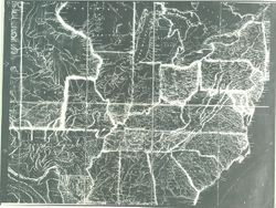
United States--Maps, Indians of North America, and American Indians
Series:
GLOVE - Local and Regional Maps
Creator:
Melish, John
Date Created:
1820
Identifier:
VAD5944-000029
Abstract:
Map of the United States with the contiguous British & Spanish possessions complied from the last authorities by John Melish. Entered according to Act o...
Call Number:
GLV145
Copyright Holder:
Public Domain
Country:
United States
Physical Description:
Scale of Miles 60 to an inch.
Holding Location:
Bloomington - Indiana University Museum of Archaeology and Anthropology 416 North Indiana Avenue Bloomington, IN 47408 Contact at iumaa@iu.edu, 812-855-6873
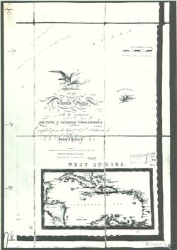
United States--Maps, American Indians, and Indians of North America
Series:
GLOVE - Local and Regional Maps
Creator:
Melish, John
Date Created:
1818
Identifier:
VAD5944-000018
Abstract:
Map of the United States with the contiguous British & Spanish possessions compiled from the latest & best authorities by John Melish. Entered accor...
Call Number:
GLV135
Copyright Holder:
Public Domain
Country:
United States
Physical Description:
Scale of Miles 60 to an inch.
Holding Location:
Bloomington - Indiana University Museum of Archaeology and Anthropology 416 North Indiana Avenue Bloomington, IN 47408 Contact at iumaa@iu.edu, 812-855-6873
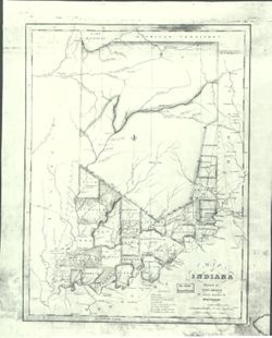
United States--Maps, Indians of North America, Indiana, and American Indians
Series:
GLOVE - Local and Regional Maps
Creator:
Melish, John
Date Created:
1819
Identifier:
VAD5944-000017
Abstract:
John Melish, the cartographer who prepared the map of Indiana on the cover of this issue [Indiana History Bulletin for December 1963, 40(12)], was born in Sc...
Call Number:
GLV134
Copyright Holder:
Public Domain
Country:
United States
Physical Description:
Scale 18 miles to an Inch.
Holding Location:
Bloomington - Indiana University Museum of Archaeology and Anthropology 416 North Indiana Avenue Bloomington, IN 47408 Contact at iumaa@iu.edu, 812-855-6873
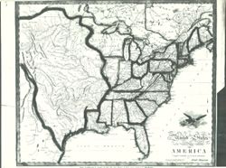
American Indians, Indians of North America, and United States--Maps
Series:
GLOVE - Local and Regional Maps
Creator:
Melish, John
Date Created:
1818
Identifier:
VAD5944-000016
Abstract:
United States of America. Compiled from the latest & best Authorities.
Call Number:
GLV133
Copyright Holder:
Public Domain
Country:
United States
Physical Description:
Scale of Miles 120 to an inch.
Holding Location:
Bloomington - Indiana University Museum of Archaeology and Anthropology 416 North Indiana Avenue Bloomington, IN 47408 Contact at iumaa@iu.edu, 812-855-6873
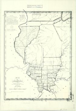
American Indians, Illinois, United States--Maps, and Indians of North America
Series:
GLOVE - Local and Regional Maps
Creator:
Melish, John
Date Created:
1818
Identifier:
VAD5944-000015
Abstract:
The lands surveyed for the military contains about 5,576,780 acres. Out of which have been selected for the British Lands, 3,500,000 acres. Remaining for s...
Call Number:
GLV132
Copyright Holder:
Public Domain
Country:
United States
Holding Location:
Bloomington - Indiana University Museum of Archaeology and Anthropology 416 North Indiana Avenue Bloomington, IN 47408 Contact at iumaa@iu.edu, 812-855-6873