
Search Constraints
You searched for:
Date Created
1922
Remove constraint Date Created: 1922
Collections
Indiana Historic Maps
Remove constraint Collections: Indiana Historic Maps
« Previous |
1 - 10 of 18
|
Next »
Search Results
-
![Indiana-Illinois Princeton quadrangle [1922 reprint without vegetation]](https://iiif.uits.iu.edu/iiif/2/0r968719t%2Ffiles%2F75ec17c9-3877-4a76-8f1a-579970db193c/full/250,/0/default.jpg)
- Subject:
- Geographic Subject: Knox County (Ind.), Geographic Subject: Wabash County (Ill.), and Geographic Subject: Gibson County (Ind.)
- Creator:
- Goodlove, C. W., Geological Survey (U.S.), Renshawe, John H., and Hawkins, Geo. T. (George T.)
- Publisher:
- Geological Survey (U.S.)
- Date Created:
- 1922
- Identifier:
- VAC3073-M-01384
- Genre:
- 15 minute topographic maps, Topographic maps, and Quadrangle maps
- Geographic Location:
- Coordinates: W0874500 W0873000 N0383000 N0381500
- Related URL:
- Catalog URL: https://iucat.iu.edu/catalog/18413584
- Abstract:
- Jno. H. Renshawe, geographer in charge , control by Geo. T. Hawkins , topography by Chas. W. Goodlove. Filing title: Princeton, Ind.-Ill. Edition of 1903. Re...
- Call Number:
- G4090 s62 .G4 Princeton 1903 rep1922
- Caption:
- Imprint: Washington, D.C. : U.S. Geological Survey, 1922
- Physical Description:
- Scale: 1:62,500 and Dimensions: 45 x 42 cm or smaller
- Alternate Identifier:
- Title Control Number: a18413584
- Persistent URL:
- https://purl.dlib.indiana.edu/iudl/images/VAC3073/VAC3073-M-01384
- Provenance:
- Part of Geological Survey (U.S.). Indiana 1:62,500.
-
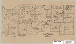
![Topographic map of a part of Lawrence County, [Indiana]](https://iiif.uits.iu.edu/iiif/2/5q47ss66t%2Ffiles%2F401d15b6-7af6-4ea5-9d01-668b0dbe5602/full/250,/0/default.jpg)
- Subject:
- Geographic Subject: Lawrence County (Ind.)
- Publisher:
- Indiana. Division of Geology
- Date Created:
- 1922
- Identifier:
- VAC3073-M-01131
- Genre:
- Topographic maps
- Geographic Location:
- Coordinates: W0864102 W0863335 N0384723 N0384112
- Related URL:
- Catalog URL: https://iucat.iu.edu/catalog/18392653
- Abstract:
- At head of title: Plate LXIX. Relief shown by contours. Detached from: Handbook of Indiana geology, part 2 / by W. N. Logan, E. R. Cumings, C. A. Malott,...
- Call Number:
- G4093.L5C2 1922 .T6
- Caption:
- Imprint: [Indianapolis] : [Wm. B. Burford], [1922] and Imprint: [Indianapolis] : [Department of Conservation, Division of Geology], [1922]
- Physical Description:
- Dimensions: 31 x 31 cm and Scale: Scale not given.
- Alternate Identifier:
- Title Control Number: a18392653 and Alternate ID: 243508IP
- Persistent URL:
- https://purl.dlib.indiana.edu/iudl/images/VAC3073/VAC3073-M-01131
- Provenance:
- Handbook of Indiana geology, part 2 (1922) / by W. N. Logan, E. R. Cumings, C. A. Malott, S. S. Visher, W. M. Tucker, J. R. Reeves.
-
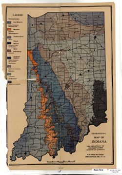
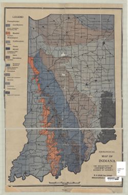
- Subject:
- Topical Subject: Geology and Geographic Subject: Indiana
- Publisher:
- Indiana. Division of Geology
- Date Created:
- 1922
- Identifier:
- VAC3073-M-01129
- Genre:
- Geological maps
- Geographic Location:
- Coordinates: W0880000 W0844500 N0414500 N0375200
- Related URL:
- Catalog URL: https://iucat.iu.edu/catalog/18392645
- Abstract:
- In Handbook of Indiana Geology, Part 2, Physiography of Indiana, between pages 106-107. Indiana Department of Conservation Publication 21. Detached from: ...
- Call Number:
- G4091.C5 1922 .I5
- Caption:
- Imprint: Indianapolis : Dept. of Conservation, Division of Geology, [1922].
- Physical Description:
- Scale: Approximately 1:1,000,000 and Dimensions: 47 x 31 cm
- Alternate Identifier:
- Title Control Number: a18392645 and Alternate ID: 243508IP
- Persistent URL:
- https://purl.dlib.indiana.edu/iudl/images/VAC3073/VAC3073-M-01129
- Provenance:
- Handbook of Indiana geology, part 2 (1922) / by W. N. Logan, E. R. Cumings, C. A. Malott, S. S. Visher, W. M. Tucker, J. R. Reeves.
-
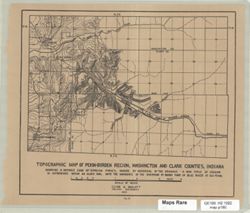
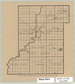
- Subject:
- Topical Subject: Erosion, Geographic Subject: Clark County (Ind.), Topical Subject: River capture, Topical Subject: Watersheds, and Geographic Subject: Washi...
- Creator:
- Malott, Clyde A.
- Publisher:
- Indiana. Division of Geology
- Date Created:
- 1922
- Identifier:
- VAC3073-M-01127
- Genre:
- Topographic maps
- Geographic Location:
- Coordinates: W0860205 W0855204 N0383209 N0382548
- Related URL:
- Catalog URL: https://iucat.iu.edu/catalog/18392358
- Abstract:
- Relief shown by contours and spot heights. Shows a "notable case of stream piracy, where by reversal of the drainage a new cycle of erosion is entrenche...
- Call Number:
- G4091.C315 1919 .M3
- Caption:
- Imprint: [Indianapolis] : [Wm. B. Burford, contractor for state printing and binding], [1922]
- Physical Description:
- Dimensions: on sheet 29 x 34 cm and Scale: Approximately 1:62,000
- Alternate Identifier:
- Title Control Number: a18392358 and Alternate ID: 243508IP
- Persistent URL:
- https://purl.dlib.indiana.edu/iudl/images/VAC3073/VAC3073-M-01127
- Provenance:
- Handbook of Indiana geology, part 2 (1922) / by W. N. Logan, E. R. Cumings, C. A. Malott, S. S. Visher, W. M. Tucker, J. R. Reeves.
-
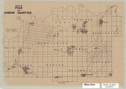
- Subject:
- Geographic Subject: Pike County (Ind.), Topical Subject: Geology, Topical Subject: Gas wells, Topical Subject: Oil wells, and Geographic Subject: Gibson Coun...
- Creator:
- Logan, William Newton, 1869-1941
- Publisher:
- Indiana. Division of Geology
- Date Created:
- 1922
- Identifier:
- VAC3073-M-01126
- Genre:
- Maps
- Geographic Location:
- Coordinates: W0873824 W0871424 N0383246 N0381912
- Related URL:
- Catalog URL: https://iucat.iu.edu/catalog/18392351
- Abstract:
- Relief shown by contours. Shows oil wells, gas wells, and dry holes. "Fig. CXXIV." Detached from: Handbook of Indiana geology, part 2 / by W. N....
- Call Number:
- G4091.H8 1922 .L6
- Caption:
- Imprint: [Indianapolis] : [Wm. B. Burford, contractor for state printing and binding], [1922]
- Physical Description:
- Scale: Approximately 1:200,000 and Dimensions: on sheet 22 x 32 cm
- Alternate Identifier:
- Title Control Number: a18392351 and Alternate ID: 243508IP
- Persistent URL:
- https://purl.dlib.indiana.edu/iudl/images/VAC3073/VAC3073-M-01126
- Provenance:
- Handbook of Indiana geology, part 2 (1922) / by W. N. Logan, E. R. Cumings, C. A. Malott, S. S. Visher, W. M. Tucker, J. R. Reeves.
-
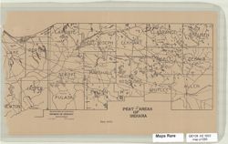
- Subject:
- Geographic Subject: Indiana, Topical Subject: Peat, and Topical Subject: Geology
- Creator:
- Logan, William Newton, 1869-1941
- Publisher:
- Indiana. Division of Geology
- Date Created:
- 1922
- Identifier:
- VAC3073-M-01125
- Genre:
- Geological maps
- Geographic Location:
- Coordinates: W0873100 W0844800 N0414500 N0404400
- Related URL:
- Catalog URL: https://iucat.iu.edu/catalog/18392650
- Abstract:
- Relief shown by contours and spot heights. Shows oil wells, gas wells, and dry holes. "Plate CLIV." Detached from: Handbook of Indiana geology,...
- Call Number:
- G4091.H9 1922 .L6
- Caption:
- Imprint: [Indianapolis] : [Wm. B. Burford, contractor for state printing and binding], [1922]
- Physical Description:
- Dimensions: on sheet 18 x 32 cm and Scale: Scale not given.
- Alternate Identifier:
- Title Control Number: a18392650 and Alternate ID: 243508IP
- Persistent URL:
- https://purl.dlib.indiana.edu/iudl/images/VAC3073/VAC3073-M-01125
- Provenance:
- Handbook of Indiana geology, part 2 (1922) / by W. N. Logan, E. R. Cumings, C. A. Malott, S. S. Visher, W. M. Tucker, J. R. Reeves.
-
- Subject:
- Geographic Subject: Indiana, Topical Subject: Marl, and Topical Subject: Geology
- Creator:
- Logan, William Newton, 1869-1941
- Publisher:
- Indiana. Division of Geology
- Date Created:
- 1922
- Identifier:
- VAC3073-M-01124
- Genre:
- Geological maps
- Geographic Location:
- Coordinates: W0873100 W0844800 N0414500 N0404400
- Related URL:
- Catalog URL: https://iucat.iu.edu/catalog/18392665
- Abstract:
- "Plate LXXXVII. Map showing the distribution of the marl deposits of Indiana." Detached from: Handbook of Indiana geology, part 2 / by W. N. Lo...
- Call Number:
- G4091.H5 1922 .L6
- Caption:
- Imprint: Wm. B. Burford, contractor for state printing and binding
- Physical Description:
- Dimensions: on sheet 18 x 32 cm and Scale: Scale not given.
- Alternate Identifier:
- Title Control Number: a18392665 and Alternate ID: 243508IP
- Persistent URL:
- https://purl.dlib.indiana.edu/iudl/images/VAC3073/VAC3073-M-01124
- Provenance:
- Handbook of Indiana geology, part 2 (1922) / by W. N. Logan, E. R. Cumings, C. A. Malott, S. S. Visher, W. M. Tucker, J. R. Reeves.
-
- Subject:
- Topical Subject: Oil fields, Geographic Subject: Vigo County (Ind.), and Topical Subject: Oil wells
- Publisher:
- Indiana. Division of Geology
- Date Created:
- 1922
- Identifier:
- VAC3073-M-01122
- Genre:
- Maps
- Geographic Location:
- Coordinates: W0873640 W0871159 N0393635 N0391538
- Related URL:
- Catalog URL: https://iucat.iu.edu/catalog/18392644
- Abstract:
- At head of title: Fig. CLI. Shows oil fields and wells. Detached from: Handbook of Indiana geology, part 2 / by W. N. Logan, E. R. Cumings, C. A. Malott, ...
- Call Number:
- G4093.V5H8 1922 .M3
- Caption:
- Imprint: [Indianapolis] : [Wm. B. Burford, contractor for state printing and binding], [1922]
- Physical Description:
- Dimensions: on sheet 21 x 19 cm and Scale: Approximately 1:220,000
- Alternate Identifier:
- Title Control Number: a18392644 and Alternate ID: 243508IP
- Persistent URL:
- https://purl.dlib.indiana.edu/iudl/images/VAC3073/VAC3073-M-01122
- Provenance:
- Handbook of Indiana geology, part 2 (1922) / by W. N. Logan, E. R. Cumings, C. A. Malott, S. S. Visher, W. M. Tucker, J. R. Reeves.
-
- Subject:
- Geographic Subject: Orange County (Ind.)
- Publisher:
- Indiana. Division of Geology
- Date Created:
- 1922
- Identifier:
- VAC3073-M-01123
- Genre:
- Topographic maps
- Geographic Location:
- Coordinates: W0864102 W0861831 N0383505 N0382349
- Related URL:
- Catalog URL: https://iucat.iu.edu/catalog/18392659
- Abstract:
- At head of title: Plate CXL. Relief shown by contours. Detached from: Handbook of Indiana geology, part 2 / by W. N. Logan, E. R. Cumings, C. A. Malott, ...
- Call Number:
- G4093.O6C28 1922 .S7
- Caption:
- Imprint: Wm. B. Burford, contractor for state printing and binding
- Physical Description:
- Scale: Approximately 1:90,500 and Dimensions: on sheet 18 x 24 cm
- Alternate Identifier:
- Alternate ID: 243508IP and Title Control Number: a18392659
- Persistent URL:
- https://purl.dlib.indiana.edu/iudl/images/VAC3073/VAC3073-M-01123
- Provenance:
- Handbook of Indiana geology, part 2 (1922) / by W. N. Logan, E. R. Cumings, C. A. Malott, S. S. Visher, W. M. Tucker, J. R. Reeves.
-
- Subject:
- Topical Subject: Geology and Geographic Subject: Indiana
- Publisher:
- Indiana. Division of Geology
- Date Created:
- 1922
- Identifier:
- VAC3073-M-01058
- Genre:
- Geological maps
- Geographic Location:
- Coordinates: W0880000 W0844500 N0414500 N0375200
- Related URL:
- Catalog URL: https://iucat.iu.edu/catalog/18392645
- Abstract:
- "R"--Lower right corner of map. "Fig. XCI." Detached from: Handbook of Indiana geology, part 2 / by W. N. Logan, E. R. Cumings, C. A. ...
- Call Number:
- G4091.C5 1922 .I4
- Caption:
- Imprint: Indianapolis : Dept. of Conservation, Division of Geology, [1922].
- Physical Description:
- Scale: Approximately 1:1,000,000 and Dimensions: 47 x 31 cm
- Alternate Identifier:
- Alternate ID: 243508IP and Title Control Number: a18392645
- Persistent URL:
- https://purl.dlib.indiana.edu/iudl/images/VAC3073/VAC3073-M-01058
- Provenance:
- Handbook of Indiana geology, part 2 (1922) / by W. N. Logan, E. R. Cumings, C. A. Malott, S. S. Visher, W. M. Tucker, J. R. Reeves.
