
Search Constraints
You searched for:
Date Created
1941
Remove constraint Date Created: 1941
Pages
0-99 pages
Remove constraint Pages: 0-99 pages
Search Results
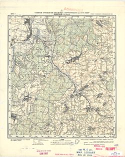
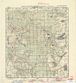
-
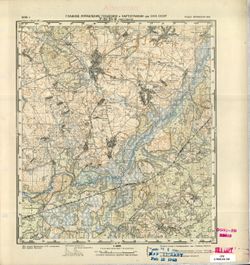
- Description:
- 1939
- Subject:
- Topical Subject: Soviet Union, Topical Subject: Maps, and Geographic Subject: Khvastovichi
- Publisher:
- Главное Управление Геодезии и Картографии при СНК СССР
- Language:
- Russian
- Date Created:
- 1941
- Identifier:
- VAC9619-001471
- Genre:
- Topographic Maps and Military Maps
- Geographic Location:
- Coordinates: 53.3333, 35, 53.5, 35.25
- Related URL:
- Catalog URL: http://iucat.iu.edu/catalog/5020131 and Download GeoTIFF: https://drive.google.com/open?id=17H03IohW7ZiEY901MozN1DRbNUl-n2L5
- Abstract:
- Modern area represented: Khvastovichi, Kaluga, Russia
- Call Number:
- G7000 s50 .S68 sheet N-36-95-C
- City:
- Хвастовичи (Khvastovichi)
- Copyright Holder:
- No Copyright - United States
- Country:
- СССР (USSR)
- State/Province:
- РСФСР (RSFSR) and Орловская область (Oryol oblast)
- Physical Description:
- Scale: 1:50,000
- Persistent URL:
- http://purl.dlib.indiana.edu/iudl/images/VAC9619/VAC9619-001471
- Provenance:
- M. I. Map Library, Atlasblatt
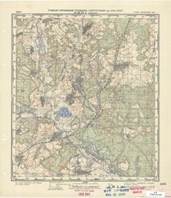
-
- Description:
- 1940
- Subject:
- Geographic Subject: Vesniny, Topical Subject: Maps, and Topical Subject: Soviet Union
- Publisher:
- Главное Управление Геодезии и Картографии при СНК СССР
- Language:
- Russian
- Date Created:
- 1941
- Identifier:
- VAC9619-001470
- Genre:
- Military Maps and Topographic Maps
- Geographic Location:
- Coordinates: 53.5, 35.25, 53.6667, 35.5
- Related URL:
- Catalog URL: http://iucat.iu.edu/catalog/5020131 and Download GeoTIFF: https://drive.google.com/open?id=1h4jB7_zufkpu5_-Zl-G434kI4Z-2knW_
- Abstract:
- Modern area represented: Vesniny, Kaluga, Russia
- Call Number:
- G7000 s50 .S68 sheet N-36-95-B
- City:
- Веснины (Vesniny)
- Copyright Holder:
- No Copyright - United States
- Country:
- СССР (USSR)
- State/Province:
- Орловская область (Oryol oblast) and РСФСР (RSFSR)
- Physical Description:
- Scale: 1:50,000
- Persistent URL:
- http://purl.dlib.indiana.edu/iudl/images/VAC9619/VAC9619-001470
- Provenance:
- CIA Map Branch -- Received
-
- Description:
- 1940
- Subject:
- Topical Subject: Maps, Geographic Subject: Lovat, and Topical Subject: Soviet Union
- Publisher:
- Главное Управление Геодезии и Картографии при СНК СССР
- Language:
- Russian
- Date Created:
- 1941
- Identifier:
- VAC9619-001469
- Genre:
- Topographic Maps and Military Maps
- Geographic Location:
- Coordinates: 53.5, 35, 53.6667, 35.25
- Related URL:
- Catalog URL: http://iucat.iu.edu/catalog/5020131 and Download GeoTIFF: https://drive.google.com/open?id=1CW7q_WmzCjxXip6vtnCVNXn4ufl3e4Yl
- Abstract:
- Modern area represented: Lovat, Kaluga, Russia
- Call Number:
- G7000 s50 .S68 sheet N-36-95-A
- Caption:
- Для служебного пользования
- City:
- Ловать (Lovat)
- Copyright Holder:
- No Copyright - United States
- Country:
- СССР (USSR)
- State/Province:
- Орловская область (Oryol oblast), РСФСР (RSFSR), and Смоленская область (Smolensk oblast)
- Physical Description:
- Scale: 1:50,000
- Persistent URL:
- http://purl.dlib.indiana.edu/iudl/images/VAC9619/VAC9619-001469
- Provenance:
- DMA Topographic Center, Army Map Service Library, OMAHA, Library of Congress Geography & Map Division
-
- Description:
- 1940
- Subject:
- Geographic Subject: Veyno, Topical Subject: Maps, and Topical Subject: Soviet Union
- Publisher:
- Главное Управление Геодезии и Картографии при СНК СССР
- Language:
- Russian
- Date Created:
- 1941
- Identifier:
- VAC9619-001431
- Genre:
- Military Maps and Topographic Maps
- Geographic Location:
- Coordinates: 53.6667, 35.75, 53.8667, 36
- Related URL:
- Catalog URL: http://iucat.iu.edu/catalog/5020131 and Download GeoTIFF: https://drive.google.com/open?id=1grHJ7pHQUKP1whRZxmXF7b1IKLZRXyb_
- Abstract:
- Modern area represented: Veyno, Kaluga oblast, Russia
- Call Number:
- GM G7000 S50 .S68 N-36-84-Г
- City:
- Вейно (Veyno)
- Copyright Holder:
- No Copyright - United States
- Country:
- СССР (USSR)
- State/Province:
- Орловская область (Oryol oblast), Тульская область (Tula oblast), РСФСР (RSFSR), and Смоленская область (Smolensk oblast)
- Physical Description:
- Scale: 1:50,000
- Persistent URL:
- http://purl.dlib.indiana.edu/iudl/images/VAC9619/VAC9619-001431
- Provenance:
- Library of Congress Geography & Map Division, Army Map Service Library, OMAHA
-
- Description:
- 1940
- Subject:
- Topical Subject: Soviet Union, Geographic Subject: Slagovishchi, and Topical Subject: Maps
- Publisher:
- Главное Управление Геодезии и Картографии при СНК СССР
- Language:
- Russian
- Date Created:
- 1941
- Identifier:
- VAC9619-001429
- Genre:
- Topographic Maps and Military Maps
- Geographic Location:
- Coordinates: 53.833, 35.75, 54, 36
- Related URL:
- Catalog URL: http://iucat.iu.edu/catalog/5020131 and Download GeoTIFF: https://drive.google.com/open?id=1oqQ_Jwap6JQmn5gSc_0feHfoVhOgIhSE
- Abstract:
- Modern area represented: Slagovishchi, Kaluga oblast, Russia
- Call Number:
- GM G7000 S50 .S68 N-36-84-B
- City:
- Слаговищи (Slagovishchi)
- Copyright Holder:
- No Copyright - United States
- Country:
- СССР (USSR)
- State/Province:
- РСФСР (RSFSR), Тульская область (Tula oblast), and Смоленская область (Smolensk oblast)
- Physical Description:
- Scale: 1:50,000
- Persistent URL:
- http://purl.dlib.indiana.edu/iudl/images/VAC9619/VAC9619-001429
- Provenance:
- G000-30, Atlasblatt, CIA Map Library, M. I. Map Library
-
- Description:
- 1940
- Subject:
- Topical Subject: Soviet Union, Topical Subject: Maps, and Geographic Subject: Ulyanovo Pervoye
- Publisher:
- Главное Управление Геодезии и Картографии при СНК СССР
- Language:
- Russian
- Date Created:
- 1941
- Identifier:
- VAC9619-001430
- Genre:
- Military Maps and Topographic Maps
- Geographic Location:
- Coordinates: 53.6667, 35.5, 53.8667, 35.75
- Related URL:
- Download GeoTIFF: https://drive.google.com/open?id=1HStfzuna63UxK3qn1yGJwA7tEgvWsEXB and Catalog URL: http://iucat.iu.edu/catalog/5020131
- Abstract:
- Modern area represented: Ulyanovo Pervoye, Kaluga oblast, Russia
- Call Number:
- GM G7000 S50 .S68 N-36-84-В
- City:
- Ульяново 1-ое (Ulyanovo Pervoye)
- Copyright Holder:
- No Copyright - United States
- Country:
- СССР (USSR)
- State/Province:
- Смоленская область (Smolensk oblast), Орловская область (Oryol oblast), and РСФСР (RSFSR)
- Physical Description:
- Scale: 1:50,000
- Persistent URL:
- http://purl.dlib.indiana.edu/iudl/images/VAC9619/VAC9619-001430
- Provenance:
- DMA Topographic Center, Army Map Service Library, OMAHA, Library of Congress Geography & Map Division
-
- Description:
- 1940
- Subject:
- Topical Subject: Soviet Union, Geographic Subject: Alëshnya, and Topical Subject: Maps
- Publisher:
- Главное Управление Геодезии и Картографии при СНК СССР
- Language:
- Russian
- Date Created:
- 1941
- Identifier:
- VAC9619-001428
- Genre:
- Topographic Maps and Military Maps
- Geographic Location:
- Coordinates: 53.8667, 35.5, 54, 35.6667
- Related URL:
- Catalog URL: http://iucat.iu.edu/catalog/5020131 and Download GeoTIFF: https://drive.google.com/open?id=1SywiDUNZ4IoJjpuIh7z5o4QfIFvFuzG0
- Abstract:
- Modern area represented: Alëshnya, Kaluga oblast, Russia
- Call Number:
- GM G7000 S50 .S68 N-36-84-A
- City:
- Алешня (Alëshnya)
- Copyright Holder:
- No Copyright - United States
- Country:
- СССР (USSR)
- State/Province:
- Смоленская область (Smolensk oblast), РСФСР (RSFSR), and Орловская область (Oryol oblast)
- Physical Description:
- Scale: 1:50,000
- Persistent URL:
- http://purl.dlib.indiana.edu/iudl/images/VAC9619/VAC9619-001428
- Provenance:
- Library of Congress Geography & Map Division, Army Map Service Library, OMAHA
-
- Description:
- 1940
- Subject:
- Geographic Subject: Chernysheno, Topical Subject: Maps, and Topical Subject: Soviet Union
- Publisher:
- Главное Управление Геодезии и Картографии при СНК СССР
- Language:
- Russian
- Date Created:
- 1941
- Identifier:
- VAC9619-001426
- Genre:
- Topographic Maps and Military Maps
- Geographic Location:
- Coordinates: 53.833, 35.25, 54, 35.5
- Related URL:
- Catalog URL: http://iucat.iu.edu/catalog/5020131 and Download GeoTIFF: https://drive.google.com/open?id=1gi0CWp89K3DqiQbjOF08akJ2ZCWIVRCp
- Abstract:
- Modern area represented: Chernysheno, Kaluga oblast, Russia
- Call Number:
- GM G7000 S50 .S68 N-36-83-B
- Caption:
- Для служебного пользования
- City:
- Чернышино (Chernysheno)
- Copyright Holder:
- No Copyright - United States
- Country:
- СССР (USSR)
- State/Province:
- Смоленская область (Smolensk oblast), Орловская область (Oryol oblast), and РСФСР (RSFSR)
- Physical Description:
- Scale: 1:50,000
- Persistent URL:
- http://purl.dlib.indiana.edu/iudl/images/VAC9619/VAC9619-001426
- Provenance:
- DMA Topographic Center, Army Map Service Library, Library of Congress Geography & Map Division
-
- Description:
- 1940
- Subject:
- Topical Subject: Soviet Union, Geographic Subject: Khotkovo, and Topical Subject: Maps
- Publisher:
- Главное Управление Геодезии и Картографии при СНК СССР
- Language:
- Russian
- Date Created:
- 1941
- Identifier:
- VAC9619-001427
- Genre:
- Military Maps and Topographic Maps
- Geographic Location:
- Coordinates: 53.667, 35, 53.833, 35.25
- Related URL:
- Catalog URL: http://iucat.iu.edu/catalog/5020131 and Download GeoTIFF: https://drive.google.com/open?id=18QTLCAcYe0vn4KzBJYmJBTAc_oV42cOi
- Abstract:
- Modern area represented: Khotkovo, Kaluga oblast, Russia
- Call Number:
- GM G7000 S50 .S68 N-36-83-C
- Caption:
- Для служебного пользования
- City:
- Хатьково (Khotkovo)
- Copyright Holder:
- No Copyright - United States
- Country:
- СССР (USSR)
- State/Province:
- Смоленская область (Smolensk oblast), Орловская область (Oryol oblast), and РСФСР (RSFSR)
- Physical Description:
- Scale: 1:50,000
- Persistent URL:
- http://purl.dlib.indiana.edu/iudl/images/VAC9619/VAC9619-001427
- Provenance:
- G000-30, Atlasblatt, CIA Map Library, M. I. Map Library
-
- Description:
- 1940
- Subject:
- Geographic Subject: Duminichi, Topical Subject: Maps, and Topical Subject: Soviet Union
- Publisher:
- Главное Управление Геодезии и Картографии при СНК СССР
- Language:
- Russian
- Date Created:
- 1941
- Identifier:
- VAC9619-001425
- Genre:
- Topographic Maps and Military Maps
- Geographic Location:
- Coordinates: 53.833, 35, 54, 35.25
- Related URL:
- Download GeoTIFF: https://drive.google.com/open?id=1-OUGxb5wYSJg2BnxEKvEbl5c4H9EJWzr and Catalog URL: http://iucat.iu.edu/catalog/5020131
- Abstract:
- Modern area represented: Duminichi, Kaluga oblast, Russia
- Call Number:
- GM G7000 S50 .S68 N-36-83-A
- City:
- Думиничи (Duminichi)
- Copyright Holder:
- No Copyright - United States
- Country:
- СССР (USSR)
- State/Province:
- Смоленская область (Smolensk oblast) and РСФСР (RSFSR)
- Physical Description:
- Scale: 1:50,000
- Persistent URL:
- http://purl.dlib.indiana.edu/iudl/images/VAC9619/VAC9619-001425
- Provenance:
- G000-30, CIA Map Library, M. I. Map Library
-
- Description:
- 1939
- Subject:
- Geographic Subject: Poselki, Topical Subject: Soviet Union, and Topical Subject: Maps
- Publisher:
- Главное Управление Геодезии и Картографии при СНК СССР
- Language:
- Russian
- Date Created:
- 1941
- Identifier:
- VAC9619-001414
- Genre:
- Military Maps and Topographic Maps
- Geographic Location:
- Coordinates: 53.667, 32.5, 53.833, 32.75
- Related URL:
- Download GeoTIFF: https://drive.google.com/open?id=1c3GJ_0bjXNnIpRcn6VIinpO86PSbBgv2 and Catalog URL: http://iucat.iu.edu/catalog/5020131
- Abstract:
- Modern area represented: Poselki, Smolensk oblast, Russia
- Call Number:
- GM G7000 S50 .S68 N-36-78-B
- Copyright Holder:
- No Copyright - United States
- Country:
- СССР (USSR)
- State/Province:
- Смоленская область (Smolensk oblast), Могилевская область (Mogilev oblast), Белорусская ССР (Byelorussian Soviet Socialist Republic), and РСФСР (RSFSR)
- Physical Description:
- Scale: 1:50,000
- Persistent URL:
- http://purl.dlib.indiana.edu/iudl/images/VAC9619/VAC9619-001414
- Provenance:
- DMA Topographic Center, Army Map Service Library, OMAHA, Library of Congress Geography & Map Division
-
- Description:
- 1937
- Subject:
- Topical Subject: Soviet Union, Geographic Subject: Dmitriyev-Lgovsky, and Topical Subject: Maps
- Publisher:
- Генеральный штаб Красной Армии
- Language:
- Russian
- Date Created:
- 1941
- Identifier:
- VAC9619-004218
- Genre:
- Military Maps and Topographic Maps
- Geographic Location:
- Coordinates: 52, 35, 52.333, 35.5
- Related URL:
- Download GeoTIFF: https://drive.google.com/file/d/1OU-PVQJtaPUnp5IG0TGZRRUM5u8JC2BC/view?usp=sharing and Catalog URL: https://iucat.iu.edu/catalog/5020129
- Abstract:
- Modern area represented: Dmitriyev-Lgovsky, Kursk oblast, Russia
- Call Number:
- G7000 s100 .S7 sheet N-36-143
- City:
- Дмитриев (Dmitriyev)
- Copyright Holder:
- No Copyright - United States
- Country:
- СССР (USSR)
- State/Province:
- Курская область (Kursk oblast) and РСФСР (RSFSR)
- Physical Description:
- Scale: 1:100,000
- Persistent URL:
- http://purl.dlib.indiana.edu/iudl/images/VAC9619/VAC9619-004218
- Provenance:
- DMA Topographic Center, Army Map Service Library, Atlasblatt
-

- Description:
- 1938
- Subject:
- Geographic Subject: Novhorod-Siverskyy, Topical Subject: Maps, and Topical Subject: Soviet Union
- Publisher:
- Главное Управление Геодезии и Картографии при СНК СССР
- Language:
- Russian
- Date Created:
- 1941
- Identifier:
- VAC9619-004216
- Genre:
- Military Maps and Topographic Maps
- Geographic Location:
- Coordinates: 52, 33, 52.333, 33.5
- Related URL:
- Download GeoTIFF: https://drive.google.com/file/d/1kaJZgYyUS6Hj_BGfB5UeL-vO4ElM_lO7/view?usp=sharing and Catalog URL: https://iucat.iu.edu/catalog/5020129
- Abstract:
- Modern area represented: Novhorod-Siverskyy, Chernihiv oblast, Ukraine
- Call Number:
- G7000 s100 .S7 sheet N-36-139
- Caption:
- Для служебного пользования
- City:
- Новгород-Северский (Novhorod-Siverskyy)
- Copyright Holder:
- No Copyright - United States
- Country:
- СССР (USSR)
- State/Province:
- Черниговская область (Chernihiv oblast), Украинская ССР (Ukrainian Soviet Socialist Republic), Сумская область (Sumy oblast), РСФСР (RSFSR), and Орловская об...
- Physical Description:
- Scale: 1:100,000
- Persistent URL:
- http://purl.dlib.indiana.edu/iudl/images/VAC9619/VAC9619-004216
- Provenance:
- DMA Topographic Center, Army Map Service Library, OMAHA, Library of Congress Geography & Map Division
-

- Description:
- 1923
- Subject:
- Topical Subject: Maps, Topical Subject: Soviet Union, and Geographic Subject: Ogorodnya
- Publisher:
- Генеральный штаб Красной Армии
- Language:
- Russian
- Date Created:
- 1941
- Identifier:
- VAC9619-004213
- Genre:
- Topographic Maps and Military Maps
- Geographic Location:
- Coordinates: 52, 31.5, 52.333, 32
- Related URL:
- Download GeoTIFF: https://drive.google.com/file/d/1MuU_oyIyusePmX5IlnPsAE4zUOKWaE3e/view?usp=sharing and Catalog URL: https://iucat.iu.edu/catalog/5020129
- Abstract:
- Modern area represented: Ogorodnya, Homyel voblasc, Belarus
- Call Number:
- G7000 s100 .S7 sheet N-36-136
- City:
- Огородня-Гомельская (Ogorodnya-Gomelskaya)
- Copyright Holder:
- No Copyright - United States
- Country:
- СССР (USSR)
- State/Province:
- Орловская область (Oryol oblast), Украинская ССР (Ukrainian Soviet Socialist Republic), Белорусская ССР (Byelorussian Soviet Socialist Republic), Черниговска...
- Physical Description:
- Scale: 1:100,000
- Persistent URL:
- http://purl.dlib.indiana.edu/iudl/images/VAC9619/VAC9619-004213
- Provenance:
- DMA Topographic Center, Army Map Service Library
-
- Description:
- 1937
- Subject:
- Topical Subject: Soviet Union, Geographic Subject: Trosna, and Topical Subject: Maps
- Publisher:
- Генеральный штаб Красной Армии
- Language:
- Russian
- Date Created:
- 1941
- Identifier:
- VAC9619-004210
- Genre:
- Topographic Maps and Military Maps
- Geographic Location:
- Coordinates: 52.333, 35.5, 52.667, 36
- Related URL:
- Download GeoTIFF: https://drive.google.com/file/d/1SObrMdlPW93jIi7PNPWF7rb-NcZPRbX-/view?usp=sharing and Catalog URL: https://iucat.iu.edu/catalog/5020129
- Abstract:
- Modern area represented: Trosna, Oryol oblast, Russia
- Call Number:
- G7000 s100 .S7 sheet N-36-132
- City:
- Тросна (Trosna)
- Copyright Holder:
- No Copyright - United States
- Country:
- СССР (USSR)
- State/Province:
- Курская область (Kursk oblast), РСФСР (RSFSR), and Орловская область (Oryol oblast)
- Physical Description:
- Scale: 1:100,000
- Persistent URL:
- http://purl.dlib.indiana.edu/iudl/images/VAC9619/VAC9619-004210
- Provenance:
- DMA Topographic Center, Auswärtiges Amt. Geographischer Dienst, OMAHA, Army Map Service Library, Library of Congress Geography & Map Division
-
- Description:
- 1937
- Subject:
- Topical Subject: Soviet Union, Geographic Subject: Dmitrovsk-Orlovskiy, and Topical Subject: Maps
- Publisher:
- Генеральный штаб Красной Армии
- Language:
- Russian
- Date Created:
- 1941
- Identifier:
- VAC9619-004209
- Genre:
- Military Maps and Topographic Maps
- Geographic Location:
- Coordinates: 52.333, 35, 52.667, 35.5
- Related URL:
- Download GeoTIFF: https://drive.google.com/file/d/109bdr_Kvs4aWF_lC7_XhQ3-WPlXh0_9r/view?usp=sharing and Catalog URL: https://iucat.iu.edu/catalog/5020129
- Abstract:
- Modern area represented: Dmitrovsk-Orlovskiy, Oryol oblast, Russia
- Call Number:
- G7000 s100 .S7 sheet N-36-131
- City:
- Дмитровск (Dmitrovsk-Orlovskiy)
- Copyright Holder:
- No Copyright - United States
- Country:
- СССР (USSR)
- State/Province:
- Орловская область (Oryol oblast), Курская область (Kursk oblast), and РСФСР (RSFSR)
- Physical Description:
- Scale: 1:100,000
- Persistent URL:
- http://purl.dlib.indiana.edu/iudl/images/VAC9619/VAC9619-004209
- Provenance:
- DMA Topographic Center, Army Map Service Library, Geographic Names Branch, Atlasblatt
-
- Description:
- 1937
- Subject:
- Geographic Subject: Lokot, Topical Subject: Soviet Union, and Topical Subject: Maps
- Publisher:
- Генеральный штаб Красной Армии
- Language:
- Russian
- Date Created:
- 1941
- Identifier:
- VAC9619-004208
- Genre:
- Military Maps and Topographic Maps
- Geographic Location:
- Coordinates: 52.333, 34.5, 52.667, 35
- Related URL:
- Download GeoTIFF: https://drive.google.com/file/d/1dYlbw4GTkP_oEsATxRiDM_A91PnKgqrP/view?usp=sharing and Catalog URL: https://iucat.iu.edu/catalog/5020129
- Abstract:
- Modern area represented: Lokot, Bryansk oblast, Russia
- Call Number:
- G7000 s100 .S7 sheet N-36-130
- City:
- Локоть (Lokot)
- Copyright Holder:
- No Copyright - United States
- Country:
- СССР (USSR)
- State/Province:
- Курская область (Kursk oblast), Орловская область (Oryol oblast), and РСФСР (RSFSR)
- Physical Description:
- Scale: 1:100,000
- Persistent URL:
- http://purl.dlib.indiana.edu/iudl/images/VAC9619/VAC9619-004208
- Provenance:
- DMA Topographic Center, Army Map Service Library, OMAHA, Library of Congress Geography & Map Division
-
- Description:
- 1940
- Subject:
- Topical Subject: Soviet Union, Topical Subject: Maps, and Geographic Subject: Kokorevka
- Publisher:
- Генеральный штаб Красной Армии
- Language:
- Russian
- Date Created:
- 1941
- Identifier:
- VAC9619-004207
- Genre:
- Military Maps and Topographic Maps
- Geographic Location:
- Coordinates: 52.333, 34, 52.667, 34.5
- Related URL:
- Download GeoTIFF: https://drive.google.com/file/d/1CdDXPK4iRkp14Oevzjr2qlP9hpMw0YQ_/view?usp=sharing and Catalog URL: https://iucat.iu.edu/catalog/5020129
- Abstract:
- Modern area represented: Kokorevka, Bryansk oblast, Russia
- Call Number:
- G7000 s100 .S7 sheet N-36-129
- City:
- Кокоревка (Kokorevka)
- Copyright Holder:
- No Copyright - United States
- Country:
- СССР (USSR)
- State/Province:
- РСФСР (RSFSR) and Орловская область (Oryol oblast)
- Physical Description:
- Scale: 1:100,000
- Persistent URL:
- http://purl.dlib.indiana.edu/iudl/images/VAC9619/VAC9619-004207
- Provenance:
- DMA Topographic Center, Army Map Service Library, Geographic Names Branch, OMAHA
-
- Description:
- 1940
- Subject:
- Geographic Subject: Trubchevsk, Topical Subject: Maps, and Topical Subject: Soviet Union
- Publisher:
- Генеральный штаб Красной Армии
- Language:
- Russian
- Date Created:
- 1941
- Identifier:
- VAC9619-004206
- Genre:
- Military Maps and Topographic Maps
- Geographic Location:
- Coordinates: 52.333, 33.5, 52.667, 34
- Related URL:
- Catalog URL: https://iucat.iu.edu/catalog/5020129 and Download GeoTIFF: https://drive.google.com/file/d/1VkrmyXpFWgso3CTd3fcWSVtTAO3Bp7U5/view?usp=sharing
- Abstract:
- Modern area represented: Trubchevsk, Bryansk oblast, Russia
- Call Number:
- G7000 s100 .S7 sheet N-36-128
- City:
- Трубчевск (Trubchevsk)
- Copyright Holder:
- No Copyright - United States
- Country:
- СССР (USSR)
- State/Province:
- Орловская область (Oryol oblast), Украинская ССР (Ukrainian Soviet Socialist Republic), Сумская область (Sumy oblast), and РСФСР (RSFSR)
- Physical Description:
- Scale: 1:100,000
- Persistent URL:
- http://purl.dlib.indiana.edu/iudl/images/VAC9619/VAC9619-004206
- Provenance:
- DMA Topographic Center, Auswärtiges Amt. Geographischer Dienst, OMAHA, Army Map Service Library
-

- Description:
- 1940
- Subject:
- Geographic Subject: Pogar, Topical Subject: Soviet Union, and Topical Subject: Maps
- Publisher:
- Генеральный штаб Красной Армии
- Language:
- Russian
- Date Created:
- 1941
- Identifier:
- VAC9619-004205
- Genre:
- Military Maps and Topographic Maps
- Geographic Location:
- Coordinates: 52.333, 33, 52.667, 33.5
- Related URL:
- Download GeoTIFF: https://drive.google.com/file/d/1-kvEoKectn1YvqFHYD5S7pgdDRdK7MO_/view?usp=sharing and Catalog URL: https://iucat.iu.edu/catalog/5020129
- Abstract:
- Modern area represented: Pogar, bryansk Oblast, Russia
- Call Number:
- G7000 s100 .S7 sheet N-36-127
- City:
- Погар (Pogar)
- Copyright Holder:
- No Copyright - United States
- Country:
- СССР (USSR)
- State/Province:
- Орловская область (Oryol oblast), Украинская ССР (Ukrainian Soviet Socialist Republic), РСФСР (RSFSR), Черниговская область (Chernihiv oblast), and Сумская о...
- Physical Description:
- Scale: 1:100,000
- Persistent URL:
- http://purl.dlib.indiana.edu/iudl/images/VAC9619/VAC9619-004205
- Provenance:
- DMA Topographic Center, Army Map Service Library, OMAHA
