Geographic Subject: Gibson County (Ind.), Topical Subject: Vegetation mapping, Geographic Subject: Wabash County (Ill.), and Geographic Subject: Knox County ...
Creator:
Geological Survey (U.S.), United States. Army Map Service, and Illinois State Geological Survey
Publisher:
Geological Survey (U.S.)
Date Created:
1964
Identifier:
VAC3073-M-01387
Genre:
Quadrangle maps, 15 minute topographic maps, and Topographic maps
Mapped, edited and published by the Geological Survey , Illinois area mapped in cooperation with State of Illinois Geological Survey. Filing title: Princeton...
Geographic Subject: Knox County (Ind.), Geographic Subject: Gibson County (Ind.), Geographic Subject: Wabash County (Ill.), and Topical Subject: Vegetation m...
Creator:
Illinois State Geological Survey, Geological Survey (U.S.), and United States. Army Map Service
Publisher:
Geological Survey (U.S.)
Date Created:
1964
Identifier:
VAC3073-M-01386
Genre:
15 minute topographic maps, Topographic maps, and Quadrangle maps
Mapped, edited and published by the Geological Survey , Illinois area mapped in cooperation with State of Illinois Geological Survey. Filing title: Princeton...
Geographic Subject: Martin County (Ind.), Topical Subject: Vegetation mapping, Geographic Subject: Lawrence County (Ind.), Geographic Subject: Monroe County ...
Creator:
Geological Survey (U.S.) and McKinley, W. K. (William Klett), 1891-1964
Publisher:
Geological Survey (U.S.)
Date Created:
1964
Identifier:
VAC3073-M-01369
Genre:
15 minute topographic maps, Quadrangle maps, and Topographic maps
Geographic Subject: Lawrence County (Ind.), Geographic Subject: Monroe County (Ind.), Geographic Subject: Martin County (Ind.), and Geographic Subject: Green...
Creator:
McKinley, W. K. (William Klett), 1891-1964 and Geological Survey (U.S.)
Publisher:
Geological Survey (U.S.)
Date Created:
1964
Identifier:
VAC3073-M-01368
Genre:
15 minute topographic maps, Topographic maps, and Quadrangle maps
Geographic Subject: Johnson County (Ind.), Geographic Subject: Bartholomew County (Ind.), Geographic Subject: Brown County (Ind.), and Topical Subject: Veget...
Creator:
Geological Survey (U.S.) and United States. Army. Corps of Engineers
Filing title: Franklin, Ind. Mapped, edited, and published by Geological Survey. Edition of 1950. Polyconic projection. Relief shown by contours and spot hei...
Geographic Subject: Brown County (Ind.), Geographic Subject: Johnson County (Ind.), Geographic Subject: Bartholomew County (Ind.), and Topical Subject: Veget...
Creator:
United States. Army. Corps of Engineers and Geological Survey (U.S.)
Filing title: Franklin, Ind. Mapped, edited, and published by Geological Survey. Edition of 1950. Polyconic projection. Relief shown by contours and spot hei...
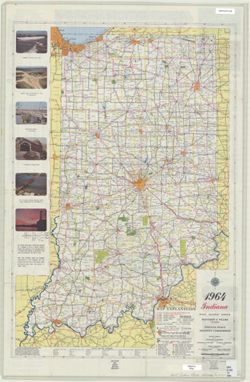
Panel title: 1964 Indiana official highway map. Relief shown by spot heights. Includes text, list of state highway garages, and color illustrations. Index, d...
Call Number:
G1403.S7 1964
Caption:
Imprint: [Indianapolis] : State Highway Commission, [1964]
Physical Description:
Dimensions: 94 x 59 cm and Scale: Approximately 1:633,600
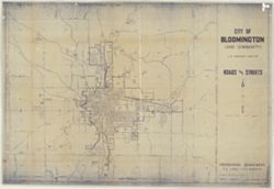
Bloomington - Indiana University Museum of Archaeology and Anthropology 416 North Indiana Avenue Bloomington, IN 47408 Contact at iumaa@indiana.edu, 812-855-6873

![Princeton quadrangle, Indiana-Illinois : 15 minute series (topographic) [1964 printing with vegetation]](https://iiif.uits.iu.edu/iiif/2/m900px89p%2Ffiles%2Fe957c77d-db8c-42d6-aef0-05abd0d3301b/full/250,/0/default.jpg)
![Princeton quadrangle, Indiana-Illinois : 15 minute series (topographic) [1964 printing with vegetation]](https://iiif.uits.iu.edu/iiif/2/ng452m35w%2Ffiles%2F49af6c65-fc22-44ea-8486-c7923f5afb8b/full/250,/0/default.jpg)
![Indiana Oolitic quadrangle : 15-minute series [1964 reprint with vegetation]](https://iiif.uits.iu.edu/iiif/2/6d571070c%2Ffiles%2Fdc8b2d50-211d-4276-b12f-039d6a003463/full/250,/0/default.jpg)
![Indiana Oolitic quadrangle : 15-minute series [1964 reprint without vegetation]](https://iiif.uits.iu.edu/iiif/2/jq086p51r%2Ffiles%2F48bb3637-851a-4213-a31e-70cd1a0b6332/full/250,/0/default.jpg)
![Franklin Quadrangle Indiana : 15 minute series (topographic) [1964 reprint with vegetation]](https://iiif.uits.iu.edu/iiif/2/73667641k%2Ffiles%2F027698b1-090b-4a4d-a44a-17bb6da9d222/full/250,/0/default.jpg)
![Franklin Quadrangle Indiana : 15 minute series (topographic) [1964 reprint with vegetation]](https://iiif.uits.iu.edu/iiif/2/6q183p48p%2Ffiles%2Fc56a46c5-d4c7-4d8d-bc73-62e73b26e4c3/full/250,/0/default.jpg)