
Search Constraints
You searched for:
Pages
0-99 pages
Remove constraint Pages: 0-99 pages
Subject
Shrubs
Remove constraint Subject: Shrubs
Subject
Clouds
Remove constraint Subject: Clouds
Subject
Grasses
Remove constraint Subject: Grasses
1 - 61 of 61
Search Results
-
- Description:
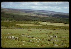
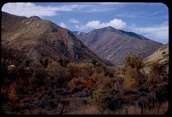
- 200 f 2.5
- Subject:
- Rocks, Moors (Wetlands), Grasses, Dartmoor (England), Grazing, Horses, Shadows, Shrubs, Clouds, Hills, and Stone walls
- Series:
- 6-61
- Creator:
- Cushman, Charles W., 1896-1972
- Date Created:
- 1961-05-08
- Genre:
- Landscape photographs
- Frame Number:
- 8
- County:
- Devon
- Abstract:
- Dartmoor
- Call Number:
- P11907
- Country:
- United Kingdom
- State/Province:
- England
- Alternate Identifier:
- 661.8
- Persistent URL:
- http://purl.dlib.indiana.edu/iudl/archives/cushman/P11907
- Holding Location:
- Bloomington - University Archives
Wells Library E460
1320 E 10th St.
Bloomington, IN 47405
Contact at archives@indiana.edu, 812-855-1127
-
- Description:
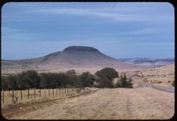
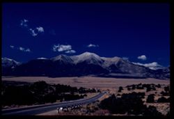
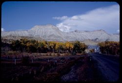
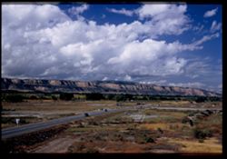
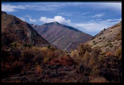
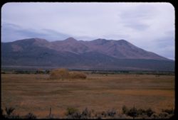
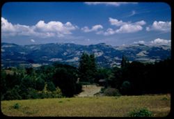
- 100 f 5.6 tl
- Subject:
- Hills, Roads, Shrubs, Trees, Buttes, Clouds, Fences, and Grasses
- Series:
- 5-59
- Creator:
- Cushman, Charles W., 1896-1972
- Date Created:
- 1959-01-19
- Genre:
- Landscape photographs
- Frame Number:
- 3
- County:
- Jeff Davis and Culberson
- Abstract:
- A butte on road to Kent
- Call Number:
- P10504
- City:
- Kent and Fort Davis
- Country:
- United States
- State/Province:
- Texas
- Alternate Identifier:
- 559.3
- Persistent URL:
- http://purl.dlib.indiana.edu/iudl/archives/cushman/P10504
- Holding Location:
- Bloomington - University Archives
Wells Library E460
1320 E 10th St.
Bloomington, IN 47405
Contact at archives@indiana.edu, 812-855-1127
-
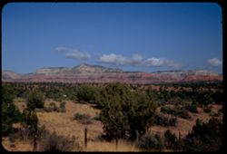
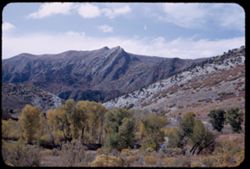
- Description:
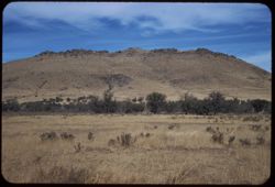
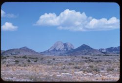
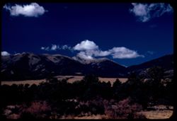
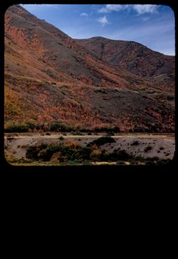
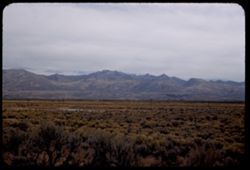
- 100 f 6.3 tl
- Subject:
- Electric lines, Davis Mountains (Tex.), Mountains, Shrubs, Clouds, and Grasses
- Series:
- 5-59
- Creator:
- Cushman, Charles W., 1896-1972
- Date Created:
- 1959-01-19
- Genre:
- Landscape photographs
- Frame Number:
- 1
- County:
- Jeff Davis
- Abstract:
- Low broad mtn.
- Call Number:
- P10502
- City:
- Fort Davis
- Country:
- United States
- State/Province:
- Texas
- Alternate Identifier:
- 559.1
- Persistent URL:
- http://purl.dlib.indiana.edu/iudl/archives/cushman/P10502
- Holding Location:
- Bloomington - University Archives
Wells Library E460
1320 E 10th St.
Bloomington, IN 47405
Contact at archives@indiana.edu, 812-855-1127
-
- Description:
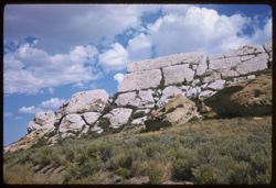
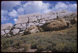
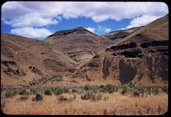
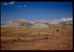
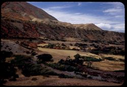
- 100 f 8 sl
- Subject:
- Grasses, Boulders, Shrubs, Muddy Gap (Wyo. : Gap), Clouds, and Rock formations
- Series:
- 17-58
- Creator:
- Cushman, Charles W., 1896-1972
- Date Created:
- 1958-08-26
- Genre:
- Landscape photographs
- Frame Number:
- 19
- County:
- Carbon
- Abstract:
- White rock ridge (not granite)
- Call Number:
- P10181
- City:
- Muddy Gap
- Country:
- United States
- State/Province:
- Wyoming
- Alternate Identifier:
- 1758.19
- Persistent URL:
- http://purl.dlib.indiana.edu/iudl/archives/cushman/P10181
- Holding Location:
- Bloomington - University Archives
Wells Library E460
1320 E 10th St.
Bloomington, IN 47405
Contact at archives@indiana.edu, 812-855-1127
-
- Description:
- 100 f 8 sl
- Subject:
- Muddy Gap (Wyo. : Gap), Shrubs, Boulders, Clouds, Rock formations, and Grasses
- Series:
- 17-58
- Creator:
- Cushman, Charles W., 1896-1972
- Date Created:
- 1958-08-26
- Genre:
- Landscape photographs
- Frame Number:
- 18
- County:
- Carbon
- Abstract:
- White rock ridge (not granite)
- Call Number:
- P10180
- City:
- Muddy Gap
- Country:
- United States
- State/Province:
- Wyoming
- Alternate Identifier:
- 1758.18
- Persistent URL:
- http://purl.dlib.indiana.edu/iudl/archives/cushman/P10180
- Holding Location:
- Bloomington - University Archives
Wells Library E460
1320 E 10th St.
Bloomington, IN 47405
Contact at archives@indiana.edu, 812-855-1127
-
- Description:
- 100 f 8 tl
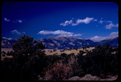
- Subject:
- Grasses, Plains, Mountains, Rock formations, Clouds, Pilot Peak (Elko County, Nev.), and Shrubs
- Series:
- 15-58
- Creator:
- Cushman, Charles W., 1896-1972
- Date Created:
- 1958-08-23
- Genre:
- Landscape photographs
- Frame Number:
- 19
- Street Address:
- United States Highway 40
- County:
- Elko
- Abstract:
- Interesting granite double peak no. of US 40 between Wells & Wendover (Pilot Peak)
- Call Number:
- P10125
- City:
- Eastline and Wells
- Country:
- United States
- State/Province:
- Nevada
- Alternate Identifier:
- 1558.19
- Persistent URL:
- http://purl.dlib.indiana.edu/iudl/archives/cushman/P10125
- Holding Location:
- Bloomington - University Archives
Wells Library E460
1320 E 10th St.
Bloomington, IN 47405
Contact at archives@indiana.edu, 812-855-1127
-
- Description:
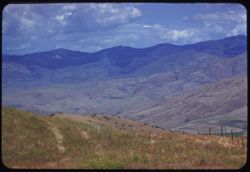
- 100 f 5.6 TL HF
- Subject:
- Boise Ridge (Idaho), Grasses, Mountains, Fences, Shrubs, Clouds, and Hills
- Series:
- 11-58
- Creator:
- Cushman, Charles W., 1896-1972
- Date Created:
- 1958-06-15
- Genre:
- Landscape photographs
- Frame Number:
- 26
- County:
- Boise
- Abstract:
- Slope of Boise ridge - hazy
- Call Number:
- P10001
- City:
- Horseshoe Bend
- Country:
- United States
- State/Province:
- Idaho
- Alternate Identifier:
- 1158.26
- Persistent URL:
- http://purl.dlib.indiana.edu/iudl/archives/cushman/P10001
- Holding Location:
- Bloomington - University Archives
Wells Library E460
1320 E 10th St.
Bloomington, IN 47405
Contact at archives@indiana.edu, 812-855-1127
-
- Description:
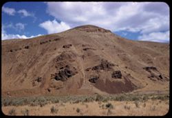
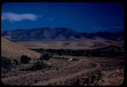
- 100 f 6.3 SL
- Subject:
- Grasses, Volcanic rock, Shrubs, Clouds, and Hills
- Series:
- 11-58
- Creator:
- Cushman, Charles W., 1896-1972
- Date Created:
- 1958-06-14
- Genre:
- Landscape photographs
- Frame Number:
- 6
- Street Address:
- United States Highway 20
- County:
- Malheur
- Abstract:
- Great brown lava
- Call Number:
- P09981
- Country:
- United States
- State/Province:
- Oregon
- Alternate Identifier:
- 1158.6
- Persistent URL:
- http://purl.dlib.indiana.edu/iudl/archives/cushman/P09981
- Holding Location:
- Bloomington - University Archives
Wells Library E460
1320 E 10th St.
Bloomington, IN 47405
Contact at archives@indiana.edu, 812-855-1127
-
- Description:
- 100 f 6.3 SL
- Subject:
- Grasses, Volcanic rock, Mountains, Shrubs, and Clouds
- Series:
- 11-58
- Creator:
- Cushman, Charles W., 1896-1972
- Date Created:
- 1958-06-14
- Genre:
- Landscape photographs
- Frame Number:
- 5
- Street Address:
- United States Highway 20
- County:
- Malheur
- Abstract:
- Great brown lava
- Call Number:
- P09980
- Country:
- United States
- State/Province:
- Oregon
- Alternate Identifier:
- 1158.5
- Persistent URL:
- http://purl.dlib.indiana.edu/iudl/archives/cushman/P09980
- Holding Location:
- Bloomington - University Archives
Wells Library E460
1320 E 10th St.
Bloomington, IN 47405
Contact at archives@indiana.edu, 812-855-1127
-
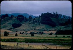
- Description:
- 100 f 4.5 tl
- Subject:
- Grasses, Trees, Fences, Shrubs, Clouds, and Hills
- Series:
- 10-56
- Creator:
- Cushman, Charles W., 1896-1972
- Date Created:
- 1956-07-13
- Genre:
- Landscape photographs
- Frame Number:
- 10
- Street Address:
- United States Highway 99
- County:
- Douglas
- Abstract:
- Country near Yoncalla
- Call Number:
- P08870
- City:
- Yoncalla
- Country:
- United States
- State/Province:
- Oregon
- Alternate Identifier:
- 1056.10
- Persistent URL:
- http://purl.dlib.indiana.edu/iudl/archives/cushman/P08870
- Holding Location:
- Bloomington - University Archives
Wells Library E460
1320 E 10th St.
Bloomington, IN 47405
Contact at archives@indiana.edu, 812-855-1127
-
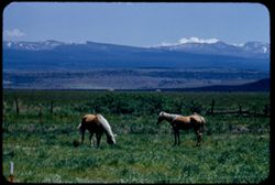
- Description:
- 100 f 6.3 tl
- Subject:
- Snow, Grasses, Grazing, Horses, Trees, Mountains, Fences, Shrubs, and Clouds
- Series:
- 18-55
- Creator:
- Cushman, Charles W., 1896-1972
- Date Created:
- 1955-06-18
- Genre:
- Identification photographs
- Frame Number:
- 16
- County:
- Modoc
- Abstract:
- Blond horses 3.3. mi south of Alturas
- Call Number:
- P08133
- City:
- Alturas
- Country:
- United States
- State/Province:
- California
- Alternate Identifier:
- 1855.16
- Persistent URL:
- http://purl.dlib.indiana.edu/iudl/archives/cushman/P08133
- Holding Location:
- Bloomington - University Archives
Wells Library E460
1320 E 10th St.
Bloomington, IN 47405
Contact at archives@indiana.edu, 812-855-1127
-
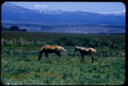
- Description:
- 100 f 6.3 tl
- Subject:
- Horses, Mountains, Shrubs, Snow, Trees, Grazing, Grasses, Fences, and Clouds
- Series:
- 18-55
- Creator:
- Cushman, Charles W., 1896-1972
- Date Created:
- 1955-06-18
- Genre:
- Identification photographs
- Frame Number:
- 15
- County:
- Modoc
- Abstract:
- Blond horses 3.3 mi south of Alturas
- Call Number:
- P08132
- City:
- Alturas
- Country:
- United States
- State/Province:
- California
- Alternate Identifier:
- 1855.15
- Persistent URL:
- http://purl.dlib.indiana.edu/iudl/archives/cushman/P08132
- Holding Location:
- Bloomington - University Archives
Wells Library E460
1320 E 10th St.
Bloomington, IN 47405
Contact at archives@indiana.edu, 812-855-1127
-
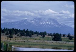
- Description:
- 100 f 6.3 tl
- Subject:
- Hills, Bodies of water, Mountains, Shrubs, Snow, Trees, Clouds, Fences, Shasta, Mount (Calif. : Mountain), and Grasses
- Series:
- 18-55
- Creator:
- Cushman, Charles W., 1896-1972
- Date Created:
- 1955-06-17
- Genre:
- Landscape photographs
- Frame Number:
- 2
- County:
- Siskiyou
- Abstract:
- Mt. Shasta at 2:35 from road east of Grenada
- Call Number:
- P08119
- City:
- Grenada
- Country:
- United States
- State/Province:
- California
- Alternate Identifier:
- 1855.2
- Persistent URL:
- http://purl.dlib.indiana.edu/iudl/archives/cushman/P08119
- Holding Location:
- Bloomington - University Archives
Wells Library E460
1320 E 10th St.
Bloomington, IN 47405
Contact at archives@indiana.edu, 812-855-1127
-
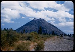
- Description:
- 50 f 6.3
- Subject:
- Cascade Range, Grasses, Roads, Shasta, Mount (Calif. : Mountain), Trees, Volcanoes, Buttes, Lassen Volcanic National Park (Calif.), Lava domes, Shrubs, Black...
- Series:
- 6-54
- Creator:
- Cushman, Charles W., 1896-1972
- Date Created:
- 1954-08-20
- Genre:
- Landscape photographs
- Frame Number:
- 31
- Street Address:
- United States Highway 99
- County:
- Siskiyou
- Abstract:
- Black Butte from N on 99.
- Call Number:
- P07248
- Country:
- United States
- State/Province:
- California
- Alternate Identifier:
- 654.31
- Persistent URL:
- http://purl.dlib.indiana.edu/iudl/archives/cushman/P07248
- Holding Location:
- Bloomington - University Archives
Wells Library E460
1320 E 10th St.
Bloomington, IN 47405
Contact at archives@indiana.edu, 812-855-1127
-
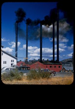
- Description:
- 50 f 9
- Subject:
- Long-Bell Lumber Co., Smokestacks, Mills, Automobiles, Lumber industry, Parking lots, Shrubs, Buildings, Clouds, Smoke, and Grasses
- Series:
- 6-54
- Creator:
- Cushman, Charles W., 1896-1972
- Date Created:
- 1954-08-20
- Frame Number:
- 29
- County:
- Siskiyou
- Abstract:
- 5 belching stacks at Long-Bell - Weed.
- Call Number:
- P07246
- City:
- Weed
- Country:
- United States
- State/Province:
- California
- Physical Description:
- masked.
- Alternate Identifier:
- 654.29
- Persistent URL:
- http://purl.dlib.indiana.edu/iudl/archives/cushman/P07246
- Holding Location:
- Bloomington - University Archives
Wells Library E460
1320 E 10th St.
Bloomington, IN 47405
Contact at archives@indiana.edu, 812-855-1127
-
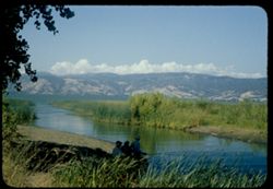
- Description:
- 50 f 9
- Subject:
- Bodies of water, Weeds, Fishing, Mountains, Shrubs, Lakes & ponds, Clouds, People, Clear Lake (Lake County, Calif.), Grasses, and Plants
- Series:
- 4-54
- Creator:
- Cushman, Charles W., 1896-1972
- Date Created:
- 1954-08-13
- Genre:
- Landscape photographs
- Frame Number:
- 17
- County:
- Lake
- Abstract:
- Clear Lake
- Call Number:
- P07191
- Country:
- United States
- State/Province:
- California
- Physical Description:
- Anscochrome film.
- Alternate Identifier:
- 454.17
- Persistent URL:
- http://purl.dlib.indiana.edu/iudl/archives/cushman/P07191
- Holding Location:
- Bloomington - University Archives
Wells Library E460
1320 E 10th St.
Bloomington, IN 47405
Contact at archives@indiana.edu, 812-855-1127
-
- Description:
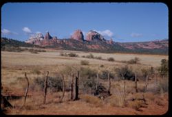
- 50 f 11
- Subject:
- Meadows, Hills, Shrubs, Grasses, Fences, Clouds, and Rock formations
- Series:
- 15-53
- Creator:
- Cushman, Charles W., 1896-1972
- Date Created:
- 1953-11-21
- Genre:
- Landscape photographs
- Frame Number:
- 26
- County:
- Coconino
- Abstract:
- Rock forms NW from Sedona
- Call Number:
- P07059
- City:
- Sedona
- Country:
- United States
- State/Province:
- Arizona
- Alternate Identifier:
- 1553.26
- Persistent URL:
- http://purl.dlib.indiana.edu/iudl/archives/cushman/P07059
- Holding Location:
- Bloomington - University Archives
Wells Library E460
1320 E 10th St.
Bloomington, IN 47405
Contact at archives@indiana.edu, 812-855-1127
-
- Description:
- 50 f 6.3 POLA
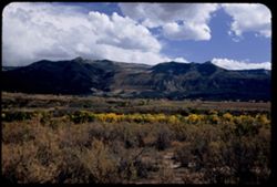
- Subject:
- Grasses, Cliffs, Mesas, Mountains, Fences, Shrubs, Clouds, Hills, and Trees
- Series:
- 15-53
- Creator:
- Cushman, Charles W., 1896-1972
- Date Created:
- 1953-11-21
- Genre:
- Landscape photographs
- Frame Number:
- 18
- Street Address:
- United States Highway 89A
- County:
- Coconino
- Abstract:
- View North
- Call Number:
- P07051
- City:
- Sedona
- Country:
- United States
- State/Province:
- Arizona
- Alternate Identifier:
- 1553.18
- Persistent URL:
- http://purl.dlib.indiana.edu/iudl/archives/cushman/P07051
- Holding Location:
- Bloomington - University Archives
Wells Library E460
1320 E 10th St.
Bloomington, IN 47405
Contact at archives@indiana.edu, 812-855-1127
-
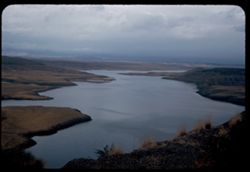
- Description:
- 50 f 8
- Subject:
- Lakes & ponds, Dams, Hills, San Carlos Lake (Ariz.), Shrubs, Reservoirs, Coolidge Dam (Ariz.), San Carlos Reservoir (Ariz.), Clouds, and Grasses
- Series:
- 13-53
- Creator:
- Cushman, Charles W., 1896-1972
- Date Created:
- 1953-11-18
- Genre:
- Landscape photographs
- Frame Number:
- 33
- Street Address:
- United States Highway 70
- Abstract:
- 4 views made from heights above San Carlos lake
- Call Number:
- P06991
- Country:
- United States
- State/Province:
- Arizona
- Alternate Identifier:
- 1353.33
- Persistent URL:
- http://purl.dlib.indiana.edu/iudl/archives/cushman/P06991
- Holding Location:
- Bloomington - University Archives
Wells Library E460
1320 E 10th St.
Bloomington, IN 47405
Contact at archives@indiana.edu, 812-855-1127
-
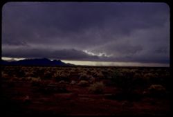
- Description:
- 50 f 3.5 Pola
- Subject:
- Grasses, Storms, Mountains, Shrubs, Whitlock Mountains (Ariz.), Clouds, and Rain
- Series:
- 13-53
- Creator:
- Cushman, Charles W., 1896-1972
- Date Created:
- 1953-11-18
- Genre:
- Landscape photographs
- Frame Number:
- 27
- Street Address:
- United States Highway 70
- County:
- Graham and Greenlee
- Abstract:
- Storm clouds moving from west toward Whitlock Mtn
- Call Number:
- P06984
- City:
- Duncan and Safford
- Country:
- United States
- State/Province:
- Arizona
- Alternate Identifier:
- 1353.27
- Persistent URL:
- http://purl.dlib.indiana.edu/iudl/archives/cushman/P06984
- Holding Location:
- Bloomington - University Archives
Wells Library E460
1320 E 10th St.
Bloomington, IN 47405
Contact at archives@indiana.edu, 812-855-1127
-
- Description:
- 50 f 8
- Subject:
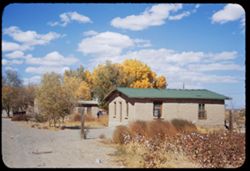
- Rocks, Cotton, Grasses, Dirt roads, Adobe buildings, Trees, Roofs, Shrubs, Clouds, and Windows
- Series:
- 13-53
- Creator:
- Cushman, Charles W., 1896-1972
- Date Created:
- 1953-11-17
- Genre:
- Views
- Frame Number:
- 15
- County:
- Dona Ana county
- Abstract:
- Cotton, adobe, & clouds at Vado N. Mex
- Call Number:
- P06972
- City:
- Vado
- Country:
- United States
- State/Province:
- New Mexico
- Alternate Identifier:
- 1353.15
- Persistent URL:
- http://purl.dlib.indiana.edu/iudl/archives/cushman/P06972
- Holding Location:
- Bloomington - University Archives
Wells Library E460
1320 E 10th St.
Bloomington, IN 47405
Contact at archives@indiana.edu, 812-855-1127
-
- Description:
- 50 f 11
- Subject:
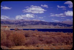
- Reservoirs, Houses, Trees, Mountains, Shrubs, Lakes & ponds, Clouds, Twin Lakes Reservoir (Lake County, Colo.), Hills, Grasses, and Waterfronts
- Series:
- 11-53
- Creator:
- Cushman, Charles W., 1896-1972
- Date Created:
- 1953-10-15
- Genre:
- Landscape photographs
- Frame Number:
- 16
- County:
- Lake
- Abstract:
- The bigger Twin Lakes
- Call Number:
- P06895
- City:
- Leadville
- Country:
- United States
- State/Province:
- Colorado
- Alternate Identifier:
- 1153.16
- Persistent URL:
- http://purl.dlib.indiana.edu/iudl/archives/cushman/P06895
- Holding Location:
- Bloomington - University Archives
Wells Library E460
1320 E 10th St.
Bloomington, IN 47405
Contact at archives@indiana.edu, 812-855-1127
-
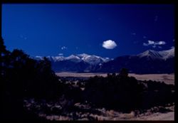
- Description:
- 50 f 11
- Subject:
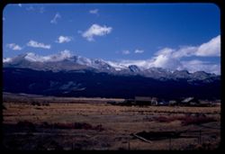
- Grasses, Houses, Dirt, Meadows, Mountains, Massive, Mount (Colo.), Shrubs, Clouds, Hills, and Fences
- Series:
- 11-53
- Creator:
- Cushman, Charles W., 1896-1972
- Date Created:
- 1953-10-15
- Genre:
- Landscape photographs
- Frame Number:
- 7
- Street Address:
- United States Highway 24
- County:
- Lake
- Abstract:
- Mt. Massive 14, 418 from US 24 just South of Leadville, Colorado
- Call Number:
- P06886
- City:
- Leadville
- Country:
- United States
- State/Province:
- Colorado
- Alternate Identifier:
- 1153.7
- Persistent URL:
- http://purl.dlib.indiana.edu/iudl/archives/cushman/P06886
- Holding Location:
- Bloomington - University Archives
Wells Library E460
1320 E 10th St.
Bloomington, IN 47405
Contact at archives@indiana.edu, 812-855-1127
-
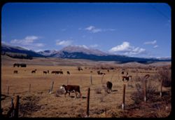
- Description:
- 50 f 9 Pola
- Subject:
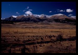
- Snow, Grasses, Grazing, Meadows, Cattle, Mountains, Fences, Shrubs, Clouds, Hills, and Elbert, Mount (Colo.)
- Series:
- 11-53
- Creator:
- Cushman, Charles W., 1896-1972
- Date Created:
- 1953-10-15
- Genre:
- Landscape photographs
- Frame Number:
- 5
- County:
- Lake
- Abstract:
- Mt. Elbert from east
- Call Number:
- P06884
- City:
- Leadville
- Country:
- United States
- State/Province:
- Colorado
- Physical Description:
- Image was originally mounted in a glass enclosure. Before digitization, the image was removed and placed in a Wess Plastic, Inc. brand, 2" x 2", pl...
- Alternate Identifier:
- 1153.5
- Persistent URL:
- http://purl.dlib.indiana.edu/iudl/archives/cushman/P06884
- Holding Location:
- Bloomington - University Archives
Wells Library E460
1320 E 10th St.
Bloomington, IN 47405
Contact at archives@indiana.edu, 812-855-1127
-
- Description:
- 50 f 11
- Subject:
- Meadows, Hills, Mountains, Shrubs, Grazing, Barns, Clouds, Fences, Cattle, Massive, Mount (Colo.), and Grasses
- Series:
- 11-53
- Creator:
- Cushman, Charles W., 1896-1972
- Date Created:
- 1953-10-15
- Genre:
- Views
- Frame Number:
- 4
- County:
- Lake
- Abstract:
- Mt. Massive from SE
- Call Number:
- P06883
- City:
- Leadville
- Country:
- United States
- State/Province:
- Colorado
- Alternate Identifier:
- 1153.4
- Persistent URL:
- http://purl.dlib.indiana.edu/iudl/archives/cushman/P06883
- Holding Location:
- Bloomington - University Archives
Wells Library E460
1320 E 10th St.
Bloomington, IN 47405
Contact at archives@indiana.edu, 812-855-1127
-
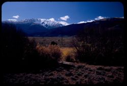
- Description:
- 50 f 7 Pola
- Subject:
- Harvard, Mount (Colo.), Meadows, Hills, Mountains, Shrubs, Snow, Trees, Shadows, Trails & paths, Clouds, Utility poles, and Grasses
- Series:
- 10-53
- Creator:
- Cushman, Charles W., 1896-1972
- Date Created:
- 1953-10-15
- Genre:
- Landscape photographs
- Frame Number:
- 38
- Street Address:
- United States Highway 24
- County:
- Pitkin
- Abstract:
- Snow crowned Mount Harvard from the Aspen road
- Call Number:
- P06878
- City:
- Aspen
- Country:
- United States
- State/Province:
- Colorado
- Alternate Identifier:
- 1053.38
- Persistent URL:
- http://purl.dlib.indiana.edu/iudl/archives/cushman/P06878
- Holding Location:
- Bloomington - University Archives
Wells Library E460
1320 E 10th St.
Bloomington, IN 47405
Contact at archives@indiana.edu, 812-855-1127
-
- Description:
- 50 f 8 Pola
- Subject:
- Rocks, Grasses, Mountains, Shrubs, Clouds, Elbert, Mount (Colo.), and Hills
- Series:
- 10-53
- Creator:
- Cushman, Charles W., 1896-1972
- Date Created:
- 1953-10-15
- Genre:
- Landscape photographs
- Frame Number:
- 37
- Street Address:
- United States Highway 24
- County:
- Chaffee
- Abstract:
- Mt. Elbert from US 24 north of Granite
- Call Number:
- P06877
- City:
- Granite
- Country:
- United States
- State/Province:
- Colorado
- Alternate Identifier:
- 1053.37
- Persistent URL:
- http://purl.dlib.indiana.edu/iudl/archives/cushman/P06877
- Holding Location:
- Bloomington - University Archives
Wells Library E460
1320 E 10th St.
Bloomington, IN 47405
Contact at archives@indiana.edu, 812-855-1127
-
- Subject:
- Antero, Mount (Colo.), Grasses, Trees, Meadows, Mountains, Shrubs, Clouds, Passes (Landforms), and Trout Creek Pass (Colo.)
- Series:
- 10-53
- Creator:
- Cushman, Charles W., 1896-1972
- Date Created:
- 1953-10-15
- Genre:
- Landscape photographs
- Frame Number:
- 35
- Street Address:
- United States Highway 24
- County:
- Chaffee
- Abstract:
- Also Mt. Antero (same)
- Call Number:
- P06875
- Country:
- United States
- State/Province:
- Colorado
- Physical Description:
- Image was originally mounted in a glass enclosure. Before digitization, the image was removed and placed in a Wess Plastic, Inc. brand, 2" x 2", pl...
- Alternate Identifier:
- 1053.35
- Persistent URL:
- http://purl.dlib.indiana.edu/iudl/archives/cushman/P06875
- Holding Location:
- Bloomington - University Archives
Wells Library E460
1320 E 10th St.
Bloomington, IN 47405
Contact at archives@indiana.edu, 812-855-1127
-
- Description:
- 50 f 7 Pola
- Subject:
- Grasses, Trees, Meadows, Mountains, Shrubs, Clouds, Hills, and Yale, Mount (Colo.)
- Series:
- 10-53
- Creator:
- Cushman, Charles W., 1896-1972
- Date Created:
- 1953-10-15
- Genre:
- Landscape photographs
- Frame Number:
- 36
- Street Address:
- United States Highway 24
- County:
- Chaffee
- Abstract:
- Mt Yale form US 24 north of Buena Vista
- Call Number:
- P06876
- City:
- Buena Vista
- Country:
- United States
- State/Province:
- Colorado
- Alternate Identifier:
- 1053.36
- Persistent URL:
- http://purl.dlib.indiana.edu/iudl/archives/cushman/P06876
- Holding Location:
- Bloomington - University Archives
Wells Library E460
1320 E 10th St.
Bloomington, IN 47405
Contact at archives@indiana.edu, 812-855-1127
-
- Description:
- 50 f 8 Pola
- Subject:
- Grasses, Trees, Meadows, Mountains, Shrubs, Clouds, Hills, and Yale, Mount (Colo.)
- Series:
- 10-53
- Creator:
- Cushman, Charles W., 1896-1972
- Date Created:
- 1953-10-15
- Genre:
- Landscape photographs
- Frame Number:
- 33
- Street Address:
- United States Highway 24
- County:
- Chaffee
- Abstract:
- Mt. Yale
- Call Number:
- P06873
- Country:
- United States
- State/Province:
- Colorado
- Alternate Identifier:
- 1053.33
- Persistent URL:
- http://purl.dlib.indiana.edu/iudl/archives/cushman/P06873
- Holding Location:
- Bloomington - University Archives
Wells Library E460
1320 E 10th St.
Bloomington, IN 47405
Contact at archives@indiana.edu, 812-855-1127
-
- Description:
- 50 f 8 Pola
- Subject:
- Railings, Grasses, Roads, Trees, Meadows, Mountains, Shrubs, Clouds, Passes (Landforms), Trout Creek Pass (Colo.), Princeton, Mount (Colo.), and Hills
- Series:
- 10-53
- Creator:
- Cushman, Charles W., 1896-1972
- Date Created:
- 1953-10-15
- Genre:
- Landscape photographs
- Frame Number:
- 32
- Street Address:
- United States Highway 24
- County:
- Chaffee
- Abstract:
- Mt. Princeton
- Call Number:
- P06872
- Country:
- United States
- State/Province:
- Colorado
- Physical Description:
- Image was originally mounted in a glass enclosure. Before digitization, the image was removed and placed in a Wess Plastic, Inc. brand, 2" x 2", pl...
- Alternate Identifier:
- 1053.32
- Persistent URL:
- http://purl.dlib.indiana.edu/iudl/archives/cushman/P06872
- Holding Location:
- Bloomington - University Archives
Wells Library E460
1320 E 10th St.
Bloomington, IN 47405
Contact at archives@indiana.edu, 812-855-1127
-
- Description:
- 50 f 6.3 Pola
- Subject:
- Valleys, Hills, Mountains, Shrubs, Grasses, and Clouds
- Series:
- 9-53
- Creator:
- Cushman, Charles W., 1896-1972
- Date Created:
- 1953-10-12
- Genre:
- Landscape photographs
- Frame Number:
- 36
- County:
- Garfield
- Abstract:
- Looking south across Grand Valley at 2:10
- Call Number:
- P06837
- City:
- Parachute
- Country:
- United States
- State/Province:
- Colorado
- Alternate Identifier:
- 953.36
- Persistent URL:
- http://purl.dlib.indiana.edu/iudl/archives/cushman/P06837
- Holding Location:
- Bloomington - University Archives
Wells Library E460
1320 E 10th St.
Bloomington, IN 47405
Contact at archives@indiana.edu, 812-855-1127
-
- Description:
- 50 f 11
- Subject:
- Grasses, Roads, Trees, Mountains, Fences, Shrubs, Clouds, Hills, Cliffs, and Bridges
- Series:
- 9-53
- Creator:
- Cushman, Charles W., 1896-1972
- Date Created:
- 1953-10-12
- Genre:
- Landscape photographs
- Frame Number:
- 35
- County:
- Mesa
- Abstract:
- Mtns near De Beque
- Call Number:
- P06836
- City:
- De Beque
- Country:
- United States
- State/Province:
- Colorado
- Alternate Identifier:
- 953.35
- Persistent URL:
- http://purl.dlib.indiana.edu/iudl/archives/cushman/P06836
- Holding Location:
- Bloomington - University Archives
Wells Library E460
1320 E 10th St.
Bloomington, IN 47405
Contact at archives@indiana.edu, 812-855-1127
-
- Description:
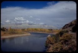
- 50 f 8 Pola
- Subject:
- Rocks, Canyons, Grasses, Roads, Automobiles, Mesas, Colorado River (Colo.-Mexico), Mountains, Shrubs, Clouds, Hills, Rivers, and Trees
- Series:
- 9-53
- Creator:
- Cushman, Charles W., 1896-1972
- Date Created:
- 1953-10-12
- Genre:
- Landscape photographs
- Frame Number:
- 34
- County:
- Mesa
- Abstract:
- View north up river around bend
- Call Number:
- P06835
- City:
- Grand Junction
- Country:
- United States
- State/Province:
- Colorado
- Alternate Identifier:
- 953.34
- Persistent URL:
- http://purl.dlib.indiana.edu/iudl/archives/cushman/P06835
- Holding Location:
- Bloomington - University Archives
Wells Library E460
1320 E 10th St.
Bloomington, IN 47405
Contact at archives@indiana.edu, 812-855-1127
-
- Description:
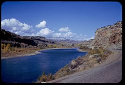
- 50 f 11
- Subject:
- Canyons, Hills, Roads, Mountains, Shrubs, Rocks, Colorado River (Colo.-Mexico), Grasses, Mesas, Horseshoe Canyon (Colo.), Clouds, and Rivers
- Series:
- 9-53
- Creator:
- Cushman, Charles W., 1896-1972
- Date Created:
- 1953-10-12
- Genre:
- Landscape photographs
- Frame Number:
- 33
- County:
- Mesa
- Abstract:
- Colorado river in Horseshoe Canyon
- Call Number:
- P06834
- City:
- Grand Junction
- Country:
- United States
- State/Province:
- Colorado
- Alternate Identifier:
- 953.33
- Persistent URL:
- http://purl.dlib.indiana.edu/iudl/archives/cushman/P06834
- Holding Location:
- Bloomington - University Archives
Wells Library E460
1320 E 10th St.
Bloomington, IN 47405
Contact at archives@indiana.edu, 812-855-1127
-
- Description:
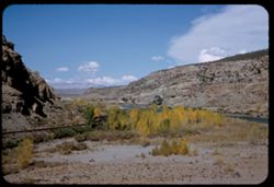
- 50 f 11
- Subject:
- Rocks, Canyons, Grasses, Colorado River (Colo.-Mexico), Horseshoe Canyon (Colo.), Mountains, Shrubs, Clouds, Hills, and Rivers
- Series:
- 9-53
- Creator:
- Cushman, Charles W., 1896-1972
- Date Created:
- 1953-10-12
- Genre:
- Landscape photographs
- Frame Number:
- 29
- County:
- Mesa
- Abstract:
- Up and [?]on the Colorado river from top of horseshoe canyon on curve 28 miles east of Grand Junction
- Call Number:
- P06830
- City:
- Grand Junction
- Country:
- United States
- State/Province:
- Colorado
- Alternate Identifier:
- 953.29
- Persistent URL:
- http://purl.dlib.indiana.edu/iudl/archives/cushman/P06830
- Holding Location:
- Bloomington - University Archives
Wells Library E460
1320 E 10th St.
Bloomington, IN 47405
Contact at archives@indiana.edu, 812-855-1127
-
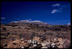
- Description:
- 50 f 8 Pola
- Subject:
- Erosion, Colorado National Monument (Colo.), Buttes, Plains, Mountains, Shrubs, Clouds, Hills, and Grasses
- Series:
- 9-53
- Creator:
- Cushman, Charles W., 1896-1972
- Date Created:
- 1953-10-12
- Genre:
- Landscape photographs
- Frame Number:
- 24
- County:
- Mesa
- Abstract:
- Buttes near Colo National Mon.
- Call Number:
- P06825
- City:
- Grand Junction
- Country:
- United States
- State/Province:
- Colorado
- Physical Description:
- Image was originally mounted in a glass enclosure. Before digitization, the image was removed and placed in a Wess Plastic, Inc. brand, 2" x 2", pl...
- Alternate Identifier:
- 953.24
- Persistent URL:
- http://purl.dlib.indiana.edu/iudl/archives/cushman/P06825
- Holding Location:
- Bloomington - University Archives
Wells Library E460
1320 E 10th St.
Bloomington, IN 47405
Contact at archives@indiana.edu, 812-855-1127
-
- Description:
- 50 f 6.3 Pola
- Subject:
- Grasses, Roads, Colorado National Monument (Colo.), Automobiles, Trees, Plains, Mountains, Shrubs, Traffic signs & signals, Clouds, Hills, and Mesas
- Series:
- 9-53
- Creator:
- Cushman, Charles W., 1896-1972
- Date Created:
- 1953-10-12
- Genre:
- Landscape photographs
- Frame Number:
- 23
- Street Address:
- United States Highway 50
- County:
- Mesa
- Abstract:
- View west from Grand Junction toward Colo Nat'l Mon.
- Call Number:
- P06824
- City:
- Grand Junction
- Country:
- United States
- State/Province:
- Colorado
- Physical Description:
- Image was originally mounted in a glass enclosure. Before digitization, the image was removed and placed in a Wess Plastic, Inc. brand, 2" x 2", pl...
- Alternate Identifier:
- 953.23
- Persistent URL:
- http://purl.dlib.indiana.edu/iudl/archives/cushman/P06824
- Holding Location:
- Bloomington - University Archives
Wells Library E460
1320 E 10th St.
Bloomington, IN 47405
Contact at archives@indiana.edu, 812-855-1127
-
- Description:
- 50 f 8
- Subject:
- Grasses, Trees, Mountains, Shrubs, Clouds, and Hills
- Series:
- 9-53
- Creator:
- Cushman, Charles W., 1896-1972
- Date Created:
- 1953-10-11
- Genre:
- Landscape photographs
- Frame Number:
- 21
- County:
- Utah
- Abstract:
- Looking back from 1 mile east of Thistle.
- Call Number:
- P06822
- City:
- Thistle
- Country:
- United States
- State/Province:
- Utah
- Alternate Identifier:
- 953.21
- Persistent URL:
- http://purl.dlib.indiana.edu/iudl/archives/cushman/P06822
- Holding Location:
- Bloomington - University Archives
Wells Library E460
1320 E 10th St.
Bloomington, IN 47405
Contact at archives@indiana.edu, 812-855-1127
-
- Description:
- 50 f 9
- Subject:
- Rocks, Grasses, Roads, Trees, Mountains, Fences, Shrubs, Clouds, and Passes (Landforms)
- Series:
- 9-53
- Creator:
- Cushman, Charles W., 1896-1972
- Date Created:
- 1953-10-11
- Genre:
- Landscape photographs
- Frame Number:
- 20
- Street Address:
- United States Highway 50
- County:
- Utah
- Abstract:
- West through same mtn. pass.
- Call Number:
- P06821
- City:
- Thistle
- Country:
- United States
- State/Province:
- Utah
- Alternate Identifier:
- 953.20
- Persistent URL:
- http://purl.dlib.indiana.edu/iudl/archives/cushman/P06821
- Holding Location:
- Bloomington - University Archives
Wells Library E460
1320 E 10th St.
Bloomington, IN 47405
Contact at archives@indiana.edu, 812-855-1127
-
- Description:
- 50 f 9
- Subject:
- Passes (Landforms), Mountains, Shrubs, Trees, Clouds, Fences, and Grasses
- Series:
- 9-53
- Creator:
- Cushman, Charles W., 1896-1972
- Date Created:
- 1953-10-11
- Genre:
- Landscape photographs
- Frame Number:
- 19
- Street Address:
- United States Highway 50
- County:
- Utah
- Abstract:
- West through same mtn. pass.
- Call Number:
- P06820
- City:
- Thistle
- Country:
- United States
- State/Province:
- Utah
- Alternate Identifier:
- 953.19
- Persistent URL:
- http://purl.dlib.indiana.edu/iudl/archives/cushman/P06820
- Holding Location:
- Bloomington - University Archives
Wells Library E460
1320 E 10th St.
Bloomington, IN 47405
Contact at archives@indiana.edu, 812-855-1127
-
- Description:
- 50 f 11
- Subject:
- Grasses, Trees, Mountains, Shrubs, Clouds, and Passes (Landforms)
- Series:
- 9-53
- Creator:
- Cushman, Charles W., 1896-1972
- Date Created:
- 1953-10-11
- Genre:
- Landscape photographs
- Frame Number:
- 18
- Street Address:
- United States Highway 50
- County:
- Utah
- Abstract:
- West through same mtn. pass.
- Call Number:
- P06819
- City:
- Thistle
- Country:
- United States
- State/Province:
- Utah
- Physical Description:
- Image was originally mounted in a glass enclosure. Before digitization, the image was removed and placed in a Wess Plastic, Inc. brand, 2" x 2", pl...
- Alternate Identifier:
- 953.18
- Persistent URL:
- http://purl.dlib.indiana.edu/iudl/archives/cushman/P06819
- Holding Location:
- Bloomington - University Archives
Wells Library E460
1320 E 10th St.
Bloomington, IN 47405
Contact at archives@indiana.edu, 812-855-1127
-
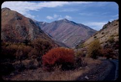
- Description:
- 50 f 5.6 Pola
- Subject:
- Pink brush, Roads, Mountains, Shrubs, Trees, Grasses, and Clouds
- Series:
- 9-53
- Creator:
- Cushman, Charles W., 1896-1972
- Date Created:
- 1953-10-11
- Genre:
- Landscape photographs
- Frame Number:
- 15
- Street Address:
- United States Highway 50
- County:
- Utah
- Abstract:
- From US 50 6 mi w of Thistle.
- Call Number:
- P06816
- City:
- Thistle
- Country:
- United States
- State/Province:
- Utah
- Physical Description:
- masked.
- Alternate Identifier:
- 953.15
- Persistent URL:
- http://purl.dlib.indiana.edu/iudl/archives/cushman/P06816
- Holding Location:
- Bloomington - University Archives
Wells Library E460
1320 E 10th St.
Bloomington, IN 47405
Contact at archives@indiana.edu, 812-855-1127
-
- Description:
- 50 f 5.6 Pola
- Subject:
- Grasses, Trees, Mountains, Fences, Shrubs, Clouds, and Hills
- Series:
- 9-53
- Creator:
- Cushman, Charles W., 1896-1972
- Date Created:
- 1953-10-11
- Genre:
- Landscape photographs
- Frame Number:
- 14
- Street Address:
- United States Highway 50
- County:
- Utah
- Abstract:
- From US 50 6 mi w of Thistle.
- Call Number:
- P06815
- City:
- Thistle
- Country:
- United States
- State/Province:
- Utah
- Alternate Identifier:
- 953.14
- Persistent URL:
- http://purl.dlib.indiana.edu/iudl/archives/cushman/P06815
- Holding Location:
- Bloomington - University Archives
Wells Library E460
1320 E 10th St.
Bloomington, IN 47405
Contact at archives@indiana.edu, 812-855-1127
-
- Description:
- 50 f 5.6 Pola
- Subject:
- Grasses, Plains, Mountains, Shrubs, Clouds, Hills, Utility poles, and Ruby Mountains (Nev.)
- Series:
- 9-53
- Creator:
- Cushman, Charles W., 1896-1972
- Date Created:
- 1953-10-10
- Genre:
- Landscape photographs
- Frame Number:
- 6
- Street Address:
- United States Highway 40
- County:
- Elko
- Abstract:
- Ruby Mtns. from US 40 between Elko + Wells. Overcast.
- Call Number:
- P06807
- City:
- Wells and Elko
- Country:
- United States
- State/Province:
- Nevada
- Alternate Identifier:
- 953.6
- Persistent URL:
- http://purl.dlib.indiana.edu/iudl/archives/cushman/P06807
- Holding Location:
- Bloomington - University Archives
Wells Library E460
1320 E 10th St.
Bloomington, IN 47405
Contact at archives@indiana.edu, 812-855-1127
-
- Description:
- 50 f 8
- Subject:
- Grasses, Grazing, Mountains, Fences, Shrubs, Cows, Clouds, Winnemucca Mountain (Nev.), Haystacks, and Hay
- Series:
- 9-53
- Creator:
- Cushman, Charles W., 1896-1972
- Date Created:
- 1953-10-10
- Genre:
- Landscape photographs
- Frame Number:
- 1
- County:
- Humboldt
- Abstract:
- Winnemucca Mtn. Under cloudy sky.
- Call Number:
- P06802
- Country:
- United States
- State/Province:
- Nevada
- Alternate Identifier:
- 953.1
- Persistent URL:
- http://purl.dlib.indiana.edu/iudl/archives/cushman/P06802
- Holding Location:
- Bloomington - University Archives
Wells Library E460
1320 E 10th St.
Bloomington, IN 47405
Contact at archives@indiana.edu, 812-855-1127
-
- Description:
- 50 f 8 Pola
- Subject:
- Hills, Roads, Dirt, Mountains, Shrubs, Trees, Grasses, and Clouds
- Series:
- 8-53
- Creator:
- Cushman, Charles W., 1896-1972
- Date Created:
- 1953-10-09
- Genre:
- Landscape photographs
- Frame Number:
- 38
- Street Address:
- United States Highway 50
- County:
- Lyon
- Abstract:
- View east from US 50 near Dayton.
- Call Number:
- P06800
- City:
- Dayton
- Country:
- United States
- State/Province:
- Nevada
- Alternate Identifier:
- 853.38
- Persistent URL:
- http://purl.dlib.indiana.edu/iudl/archives/cushman/P06800
- Holding Location:
- Bloomington - University Archives
Wells Library E460
1320 E 10th St.
Bloomington, IN 47405
Contact at archives@indiana.edu, 812-855-1127
-
- Description:
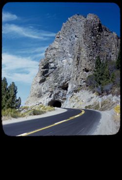
- 50 f 8
- Subject:
- Grasses, Roads, Trees, Dirt, Mountains, Tahoe, Lake (Calif. and Nev.), Traffic signs & signals, Clouds, Tunnels, Shrubs, and Rock formations
- Series:
- 8-53
- Creator:
- Cushman, Charles W., 1896-1972
- Date Created:
- 1953-10-09
- Genre:
- Snapshots
- Frame Number:
- 31
- Street Address:
- United States Highway 50
- Abstract:
- Mouth of tunnel on US 50 along SE shore of L. Tahoe in Nevada.
- Call Number:
- P06793
- Country:
- United States
- State/Province:
- Nevada
- Physical Description:
- masked.
- Alternate Identifier:
- 853.31
- Persistent URL:
- http://purl.dlib.indiana.edu/iudl/archives/cushman/P06793
- Holding Location:
- Bloomington - University Archives
Wells Library E460
1320 E 10th St.
Bloomington, IN 47405
Contact at archives@indiana.edu, 812-855-1127
-
- Description:
- 25 f 7 Pola
- Subject:
- Grasses, Trees, Meadows, Mountains, Fences, Shrubs, Sonoma Mountain (Calif.), Clouds, and Hills
- Series:
- 8-53
- Creator:
- Cushman, Charles W., 1896-1972
- Date Created:
- 1953-08-30
- Genre:
- Landscape photographs
- Frame Number:
- 6
- County:
- Sonoma
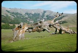
- Abstract:
- From Sonoma Mtn road. a mile or so to the east.
- Call Number:
- P06769
- Country:
- United States
- State/Province:
- California
- Alternate Identifier:
- 853.6
- Persistent URL:
- http://purl.dlib.indiana.edu/iudl/archives/cushman/P06769
- Holding Location:
- Bloomington - University Archives
Wells Library E460
1320 E 10th St.
Bloomington, IN 47405
Contact at archives@indiana.edu, 812-855-1127
-
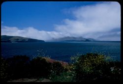
- Description:
- 25 f 8 Pola
- Subject:
- Bays (Bodies of water), Grasses, Houses, Fog, Flowers, Roofs, Shrubs, Clouds, Tomales Bay (Calif.), Bleu Baie Tavern (Marshall, Calif.), and Pacific Coast Hi...
- Series:
- 7-53
- Creator:
- Cushman, Charles W., 1896-1972
- Date Created:
- 1953-07-08
- Genre:
- Views
- Frame Number:
- 26
- Street Address:
- California State Highway 1
- County:
- Marin
- Abstract:
- Tomales Bay from cove at Bleu Baie Tavern 3 mi. north of Marshall on Calif. 1.
- Call Number:
- P06751
- City:
- Marshall
- Country:
- United States
- State/Province:
- California
- Alternate Identifier:
- 753.26
- Persistent URL:
- http://purl.dlib.indiana.edu/iudl/archives/cushman/P06751
- Holding Location:
- Bloomington - University Archives
Wells Library E460
1320 E 10th St.
Bloomington, IN 47405
Contact at archives@indiana.edu, 812-855-1127
-
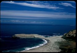
- Description:
- 50 f 6.3 Pola
- Subject:
- Ocean waves, Sand, Pacific Ocean, Pacific Coast (Calif.), Shrubs, Oceans, Coastlines, Beaches, Grasses, Wildflowers, Clouds, and Dunes
- Series:
- 7-53
- Creator:
- Cushman, Charles W., 1896-1972
- Date Created:
- 1953-06-11
- Genre:
- Seascapes
- Frame Number:
- 2
- Street Address:
- California State Highway 1
- County:
- Santa Cruz
- Abstract:
- Pacific Coast along Hwy 1 near Devenport
- Call Number:
- P06727
- City:
- Davenport
- Country:
- United States
- State/Province:
- California
- Alternate Identifier:
- 753.2
- Persistent URL:
- http://purl.dlib.indiana.edu/iudl/archives/cushman/P06727
- Holding Location:
- Bloomington - University Archives
Wells Library E460
1320 E 10th St.
Bloomington, IN 47405
Contact at archives@indiana.edu, 812-855-1127
-
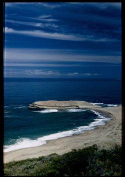
- Description:
- 50 f 8 Pola
- Subject:
- Wildflowers, Oceans, Grasses, Ocean waves, Sand, Coastlines, Pacific Ocean, Beaches, Shrubs, Pacific Coast (Calif.), and Clouds
- Series:
- 7-53
- Creator:
- Cushman, Charles W., 1896-1972
- Date Created:
- 1953-06-11
- Genre:
- Seascapes
- Frame Number:
- 1
- Street Address:
- California State Highway 1
- County:
- Santa Cruz
- Abstract:
- Pacific Coast along Hwy 1 near Devenport.
- Call Number:
- P06726
- City:
- Davenport
- Country:
- United States
- State/Province:
- California
- Physical Description:
- Image was originally mounted in a glass enclosure. Before digitization, the image was removed and placed in a Wess Plastic, Inc. brand, 2" x 2", pl...
- Alternate Identifier:
- 753.1
- Persistent URL:
- http://purl.dlib.indiana.edu/iudl/archives/cushman/P06726
- Holding Location:
- Bloomington - University Archives
Wells Library E460
1320 E 10th St.
Bloomington, IN 47405
Contact at archives@indiana.edu, 812-855-1127
-
- Description:
- 25 f 11
- Subject:
- Grasses, Trees, Shrubs, Clouds, San Francisco Peninsula (Calif.), and Hills
- Series:
- 4-53
- Creator:
- Cushman, Charles W., 1896-1972
- Date Created:
- 1953-05-01
- Genre:
- Landscape photographs
- Frame Number:
- 38
- Street Address:
- La Honda Road
- County:
- San Mateo
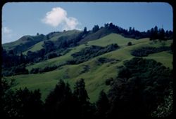
- Abstract:
- Green mountain side from La Honda road - SF Peninsula. May 1.
- Call Number:
- P06649
- Country:
- United States
- State/Province:
- California
- Alternate Identifier:
- 453.38
- Persistent URL:
- http://purl.dlib.indiana.edu/iudl/archives/cushman/P06649
- Holding Location:
- Bloomington - University Archives
Wells Library E460
1320 E 10th St.
Bloomington, IN 47405
Contact at archives@indiana.edu, 812-855-1127
-
- Description:
- 25 f 9
- Subject:
- Grasses, Trees, Shrubs, Clouds, and Hills
- Series:
- 2-53
- Creator:
- Cushman, Charles W., 1896-1972
- Date Created:
- 1953-01-29
- Genre:
- Landscape photographs
- Frame Number:
- 11
- County:
- Marin
- Abstract:
- Marin county.
- Call Number:
- P06545
- Country:
- United States
- State/Province:
- California
- Alternate Identifier:
- 253.11
- Persistent URL:
- http://purl.dlib.indiana.edu/iudl/archives/cushman/P06545
- Holding Location:
- Bloomington - University Archives
Wells Library E460
1320 E 10th St.
Bloomington, IN 47405
Contact at archives@indiana.edu, 812-855-1127
-
- Description:
- 25 f 8
- Subject:
- Botanical gardens, Grasses, Trees, Morton Arboretum, Shadows, Acer negundo, Shrubs, and Clouds
- Series:
- 10-50
- Creator:
- Cushman, Charles W., 1896-1972
- Date Created:
- 1950-10-10
- Genre:
- Identification photographs
- Frame Number:
- 15
- County:
- Du Page
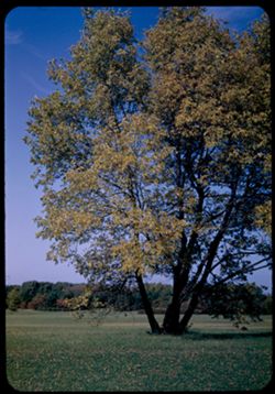
- Abstract:
- Acer Negundo [Box Elder] and Stately Box Elder (Acer Negundo) in meadow of Arb. E.
- Call Number:
- P04880
- City:
- Wheaton
- Country:
- United States
- State/Province:
- Illinois
- Alternate Identifier:
- 1050.15
- Persistent URL:
- http://purl.dlib.indiana.edu/iudl/archives/cushman/P04880
- Holding Location:
- Bloomington - University Archives
Wells Library E460
1320 E 10th St.
Bloomington, IN 47405
Contact at archives@indiana.edu, 812-855-1127
-
- Description:
- 50 f 5.6
- Subject:
- Dell Creek (Wis.), Grasses, Grazing, Dells of the Wisconsin (Wis.), Shrubs, Lakes & ponds, Clouds, Reflections, Trees, and Cows
- Series:
- 8-50
- Creator:
- Cushman, Charles W., 1896-1972
- Date Created:
- 1950-07-17
- Genre:
- Identification photographs
- Frame Number:
- 3
- Street Address:
- Wisconsin State Highway 23
- County:
- Sauk
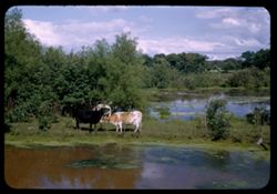
- Abstract:
- Cows grazing along Dell Creek -Wisc. Hwy 23 Cows at Dell Vreek Hwy 23 W
- Call Number:
- P04830
- City:
- Dell Creek
- Country:
- United States
- State/Province:
- Wisconsin
- Alternate Identifier:
- 850.3
- Persistent URL:
- http://purl.dlib.indiana.edu/iudl/archives/cushman/P04830
- Holding Location:
- Bloomington - University Archives
Wells Library E460
1320 E 10th St.
Bloomington, IN 47405
Contact at archives@indiana.edu, 812-855-1127
-
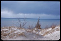
- Description:
- 125 f 5.6
- Subject:
- Storms, Lakes & ponds, Michigan, Lake, Sand, Shrubs, Clouds, Grasses, and Dunes
- Series:
- 1-47
- Creator:
- Cushman, Charles W., 1896-1972
- Date Created:
- 1947-04-17
- Genre:
- Seascapes and Landscape photographs
- Frame Number:
- 15
- County:
- Porter
- Abstract:
- Sand dunes and Lake Mich. Under lowering sky. Views from hts. At Dune Acres, Ind.
- Call Number:
- P03621
- City:
- Dune Acres
- Country:
- United States
- State/Province:
- Indiana
- Alternate Identifier:
- 147.15
- Persistent URL:
- http://purl.dlib.indiana.edu/iudl/archives/cushman/P03621
- Holding Location:
- Bloomington - University Archives
Wells Library E460
1320 E 10th St.
Bloomington, IN 47405
Contact at archives@indiana.edu, 812-855-1127
-
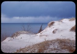
- Description:
- 125 f 5.6
- Subject:
- Grasses, Sand, Trees, Dunes, Storms, Michigan, Lake, Shrubs, Lakes & ponds, and Clouds
- Series:
- 1-47
- Creator:
- Cushman, Charles W., 1896-1972
- Date Created:
- 1947-04-17
- Genre:
- Landscape photographs and Seascapes
- Frame Number:
- 14
- County:
- Porter
- Abstract:
- Sand dunes and Lake Mich. Under lowering sky. Views from hts. At Dune Acres, Ind.
- Call Number:
- P03620
- City:
- Dune Acres
- Country:
- United States
- State/Province:
- Indiana
- Alternate Identifier:
- 147.14
- Persistent URL:
- http://purl.dlib.indiana.edu/iudl/archives/cushman/P03620
- Holding Location:
- Bloomington - University Archives
Wells Library E460
1320 E 10th St.
Bloomington, IN 47405
Contact at archives@indiana.edu, 812-855-1127
-
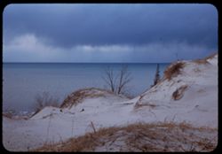
- Description:
- 125 f 5.6
- Subject:
- Storms, Lakes & ponds, Michigan, Lake, Sand, Shrubs, Clouds, Grasses, and Dunes
- Series:
- 1-47
- Creator:
- Cushman, Charles W., 1896-1972
- Date Created:
- 1947-04-17
- Genre:
- Seascapes and Landscape photographs
- Frame Number:
- 13
- County:
- Porter
- Abstract:
- Sand dunes and Lake Mich. Under lowering sky. Views from hts. At Dune Acres, Ind.
- Call Number:
- P03619
- City:
- Dune Acres
- Country:
- United States
- State/Province:
- Indiana
- Alternate Identifier:
- 147.13
- Persistent URL:
- http://purl.dlib.indiana.edu/iudl/archives/cushman/P03619
- Holding Location:
- Bloomington - University Archives
Wells Library E460
1320 E 10th St.
Bloomington, IN 47405
Contact at archives@indiana.edu, 812-855-1127
-
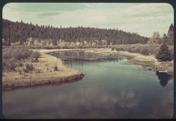
- Subject:
- National parks & reserves, Reflections, Madison River (Wyo. and Mont.), Forests, Shrubs, Trees, Rivers, Yellowstone National Park, Clouds, and Grasses
- Series:
- 6-38
- Creator:
- Cushman, Charles W., 1896-1972
- Date Created:
- 1938-09-29
- Genre:
- Landscape photographs
- Frame Number:
- 9
- Abstract:
- F-9= Madison river in the morning
- Call Number:
- P01496
- Country:
- United States
- State/Province:
- Wyoming and Montana
- Physical Description:
- some dye fading. Image was originally mounted in a glass enclosure. Before digitization, the image was removed and placed in a Wess Plastic, Inc. brand, 2&qu...
- Alternate Identifier:
- 638.9
- Persistent URL:
- http://purl.dlib.indiana.edu/iudl/archives/cushman/P01496
- Holding Location:
- Bloomington - University Archives
Wells Library E460
1320 E 10th St.
Bloomington, IN 47405
Contact at archives@indiana.edu, 812-855-1127
-
- Subject:
- Grasses, Madison River (Wyo. and Mont.), National parks & reserves, Clouds, Forests, Reflections, Rivers, Trees, Shrubs, and Yellowstone National Park
- Series:
- 6-38
- Creator:
- Cushman, Charles W., 1896-1972
- Date Created:
- 1938-09-30
- Genre:
- Landscape photographs
- Frame Number:
- 9
- Abstract:
- F-9= Madison river in the morning
- Call Number:
- P15797
- Country:
- United States
- State/Province:
- Wyoming and Montana
- Physical Description:
- Color corrected: magenta cast [fading of yellow dye]. Image was originally mounted in a glass enclosure. Before digitization, the image was removed and place...
- Alternate Identifier:
- 638.9
- Persistent URL:
- http://purl.dlib.indiana.edu/iudl/archives/cushman/P15797
- Holding Location:
- Bloomington - University Archives
Wells Library E460
1320 E 10th St.
Bloomington, IN 47405
Contact at archives@indiana.edu, 812-855-1127