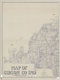
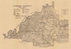
Relief shown by spot heights. "Based upon[:] B. F. & Co.'s Atlas of Indiana, 1876. Lake's Atlas of Gibson and Pike Counties, 1881. F. C. H. ...
Call Number:
QE109 .A2 1898 map p1408
Caption:
Imprint: Indianapolis, Ind. : Wm. B. Burford, [1899]
Physical Description:
Scale: Approximately 1:126,720. 2 miles = 1 inch and Dimensions: 78 x 48 cm
Alternate Identifier:
Title Control Number: a18188198 and Alternate ID: 390726IP
Provenance:
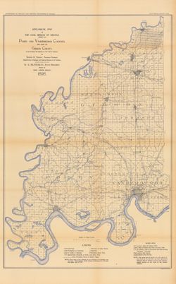
23rd Annual Report (1898) / Indiana. Department of Geology and Natural Resources.
Topical Subject: Land use and Geographic Subject: Gibson County (Ind.)
Creator:
Gibson County (Ind.). Land Use Planning Committee
Publisher:
United States. Bureau of Agricultural Economics
Date Created:
1941
Identifier:
VAC3073-M-00705
Genre:
Thematic maps
Geographic Location:
Coordinates: W0875917 W0871856 N0383200 N0380955
Related URL:
Catalog URL: https://iucat.iu.edu/catalog/5126313
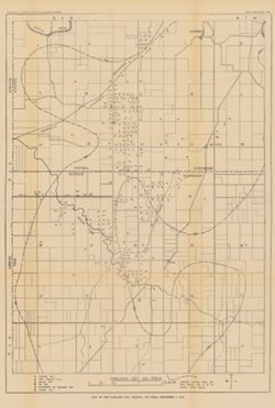
Abstract:
"Color reproduction by Bureau of Agricultural Economics, U.S.D.A." "7-31-41". Includes chart showing type of land use, acreage, and recom...
Call Number:
G4093.G5G4 1941 .G53
Caption:
Imprint: [Washington, D.C.?] : U.S. Bureau of Agricultural Economics, [1941]
Physical Description:
Dimensions: 18 x 26 cm, on sheet 38 x 28 cm and Scale: Scale not given.
Geographic Subject: Pike County (Ind.), Geographic Subject: Oakland City (Ind.), Geographic Subject: Gibson County (Ind.), Topical Subject: Gas wells, Topica...
Publisher:
Indiana. Department of Geology and Natural Resources
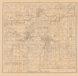
Shows oil and gas wells. "Structure contours above sea level showing coal V or its position before erosion."--Legend. Detached from: The Oakland...
Call Number:
G4094.O2H8 1910 .M3
Caption:
Imprint: [Indianapolis] : [Indiana Dept. of Geology and Natural Resources], [1911]
Physical Description:
Scale: Approximately 1:21,500 and Dimensions: 57 x 40 cm
Alternate Identifier:
Title Control Number: a18307759 and Alternate ID: 390726IP
Provenance:
35th Annual Report (1910) / Indiana. Department of Geology and Natural Resources.
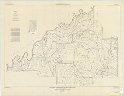
Shows wells drilling, wells producing oil, wells producing oil and gas, wells plugged or abandoned, dry wells, wells drilled in 1891, and power houses. Also ...
Call Number:
G4093.G5H8 1906 .B5
Caption:
Imprint: [Indianapolis] : [Wm. B. Burford], [1907] and Imprint: [Indianapolis] : [Indiana Department of Geology and Natural Resources], [1907]
Physical Description:
Dimensions: 44 x 47 cm and Scale: Approximately 1:126,720. 2 miles = 1 inch
Alternate Identifier:
Alternate ID: 390726IP and Title Control Number: a16160959
Provenance:
31st Annual Report (1906) / Indiana. Department of Geology and Natural Resources.
Shows public roads and railroads. Detached from: A soil survey of Randolph, Wayne, Henry, Rush, Fayette, Union and Franklin counties / Arthur E. Taylor. I...
Call Number:
G4093.G5J3 1909 .S5
Caption:
Imprint: [Indianapolis] : [Indiana Department of Geology and Natural Resources], [1910]
Physical Description:
Dimensions: 37 x 54 cm and Scale: Approximately 1:126,720
Alternate Identifier:
Title Control Number: a16091035 and Alternate ID: 390726IP
Provenance:
34th Annual Report (1909) / Indiana. Department of Geology and Natural Resources.

![Gibson County [Indiana] preliminary land use map](https://iiif.uits.iu.edu/iiif/2/f7624g240%2Ffiles%2F91ddcfae-bfc8-40ae-a801-4b23f126742f/full/250,/0/default.jpg)