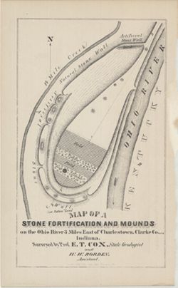
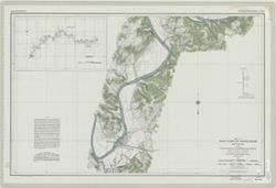
Surveyed by Prof. E. T. Cox and W. W. Borden. Pictorial map showing natural and artificial stone walls surrounding fields, timber, and mounds between the Ohi...
Call Number:
G4093.C4R4 1873 .C69
Caption:
Imprint: Indianapolis : Braden & Burford, Steam Lith., [1873] and Imprint: [Indianapolis] : [Geological Survey of Indiana], [1874]
Physical Description:
Dimensions: on sheet 22 x 14 cm and Scale: Scale not given.
Alternate Identifier:
Title Control Number: a18318556 and Alternate ID: 390723IP
Geographic Subject: Eel River (Putnam County-Greene County, Ind.), Topical Subject: Navigation, and Topical Subject: Rivers
Creator:
United States. Army. Corps of Engineers. Louisville District
Publisher:
[United States Engineer Office]
Date Created:
1931
Identifier:
VAC3073-M-01502
Genre:
Nautical charts
Geographic Location:
Coordinates: W0871900 W0865600 N0393000 N0390600
Related URL:
Catalog URL: https://iucat.iu.edu/catalog/6468587
Abstract:
Surveyed and mapped under the direction of The United States Engineer Office, Louisville, Ky. Relief shown by contours and spot heights. Depths shown by so...
Call Number:
G4092.E37 P53 1931 .U5
Caption:
Imprint: [Louisville, Ky.] : [United States Engineer Office], [1931]
Physical Description:
Scale: 1:12,000 and Dimensions: 93 x 96 cm or smaller
Some charts have imprint: Fort Belvoir, Va.: 30th Engineers by reproduction plant, 1943, or Washington, D.C.: Engineer reproduction plant, U.S. Army, 1929.
Call Number:
G3707.O5 1911 .U55
Caption:
Imprint: Detroit, Michigan : U.S. Lake Survey Office, 1911-1914.
Topical Subject: Rivers, Topical Subject: Valleys, Geographic Subject: Wabash River, and Geographic Subject: Wabash River Valley
Creator:
Williams & Heintz Co.
Publisher:
United States. Army. Corps of Engineers. Louisville District.
Date Created:
1930
Identifier:
VAC3073-M-01501
Genre:
Nautical charts
Geographic Location:
Coordinates: W0880700 W0843300 N0405700 N0374700
Related URL:
Catalog URL: https://iucat.iu.edu/catalog/6799690
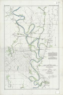
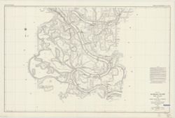
Abstract:
Surveyed and mapped under the direction of the United States engineer officer, Louisville, Ky. 1930. Relief shown by contours and spot heights. Depths sho...
Call Number:
G4072.W3 1930 .U5
Caption:
Imprint: Washington, D.C. : Williams & Heintz Co., 1931.
Physical Description:
Scale: 1:24,000 and Dimensions: 64 x 96 cm, on sheets 72 x 107 cm
Topical Subject: Rivers, Topical Subject: Navigation, and Geographic Subject: White River (Ind. : River)
Creator:
United States. Army. Corps of Engineers. Louisville District
Publisher:
[United States Engineer Office]
Date Created:
1931
Identifier:
VAC3073-M-01494
Genre:
Nautical charts
Geographic Location:
Coordinates: W0872200 W0860800 N0394400 N0383600
Related URL:
Catalog URL: https://iucat.iu.edu/catalog/6493899
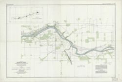
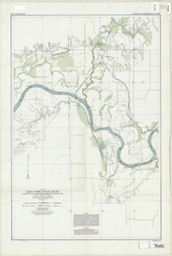
Abstract:
Surveyed and mapped under the direction of The United States Engineer Office, Louisville, Ky. Relief shown by contours and spot heights. Depths shown by s...
Call Number:
G4092.W5 P53 1931 .U53
Caption:
Imprint: [Louisville, Ky.] : [United States Engineer Office], [1931]
Physical Description:
Dimensions: 92 x 97 cm or smaller and Scale: 1:12,000
Topical Subject: Navigation, Geographic Subject: White River (Ind. : River), and Topical Subject: Rivers
Creator:
United States. Army. Corps of Engineers. Louisville District
Publisher:
[United States Engineer Office]
Date Created:
1931
Identifier:
VAC3073-M-01492
Genre:
Nautical charts
Geographic Location:
Coordinates: W0861500 W0864900 N0391200 N0384500
Related URL:
Catalog URL: https://iucat.iu.edu/catalog/6799804
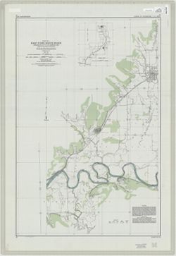
Abstract:
Surveyed and mapped under the direction of The United States Engineer Office, Louisville, Ky. Relief shown by contours and spot heights. Depths shown by so...
Call Number:
G4092.W5P53 1931 .U52
Caption:
Imprint: [Louisville, Ky.] : [United States Engineer Office], [1931]
Physical Description:
Dimensions: 92 x 97 cm or smaller and Scale: 1:12,000
Geographic Subject: White River (Ind. : River), Topical Subject: Navigation, and Topical Subject: Rivers
Creator:
United States. Army. Corps of Engineers. Louisville District
Publisher:
[United States Engineer Office]
Date Created:
1931
Identifier:
VAC3073-M-01491
Genre:
Nautical charts
Geographic Location:
Coordinates: W0865100 W0861300 N0385300 N0383900
Related URL:
Catalog URL: https://iucat.iu.edu/catalog/6799725
Abstract:
Surveyed and mapped under the direction of The United States Engineer Office, Louisville, Ky. Relief shown by contours and spot heights. Depths shown by so...
Call Number:
G4092.W5P53 1929 .U52
Caption:
Imprint: [Louisville, Ky.] : [United States Engineer Office], [1931]
Physical Description:
Scale: 1:12,000 and Dimensions: 92 x 97 cm or smaller
Geographic Subject: White River (Ind. : River), Topical Subject: Rivers, and Topical Subject: Navigation
Creator:
United States. Army. Corps of Engineers. Louisville District
Publisher:
[United States Engineer Office]
Date Created:
1931
Identifier:
VAC3073-M-01490
Genre:
Nautical charts
Geographic Location:
Coordinates: W0871300 W0864600 N0384200 N0382800
Related URL:
Catalog URL: https://iucat.iu.edu/catalog/6451606
Abstract:
Surveyed and mapped under the direction of The United States Engineer Office, Louisville, Ky. Relief shown by contours and spot heights. Depths shown by so...
Call Number:
G4092.W5 P53 1931 .U52
Caption:
Imprint: [Louisville, Ky.] : [United States Engineer Office], [1931]
Physical Description:
Dimensions: 92 x 97 cm or smaller and Scale: 1:12,000
Geographic Subject: Indiana, Topical Subject: Rivers, and Geographic Subject: Wabash River
Creator:
United States. Army. Corps of Engineers
Publisher:
United States. Army. Corps of Engineers. Louisville District
Date Created:
Circa 1931
Identifier:
VAC3073-M-01487
Genre:
Nautical charts
Geographic Location:
Coordinates: W0881100 W0872000 N0392900 N0374700
Related URL:
Catalog URL: https://iucat.iu.edu/catalog/5485820
Abstract:
Surveyed and mapped under the direction of the United States engineer officer, Louisville, Ky. Relief shown by contours and spot heights. Depths shown by s...
Call Number:
G4072.W3 C315 1931 .U55
Caption:
Imprint: [Louisville, Ky.? , 1931?]
Physical Description:
Dimensions: sheets 92 x 122 cm and Scale: Approximately 1:24,000