
Image
State highway system of Indiana [1924] Público Deposited
- Genre
- Road maps
- Location
- Coordinates: W0880500 W0844700 N0414500 N0374600
- Related URL
- Abstract
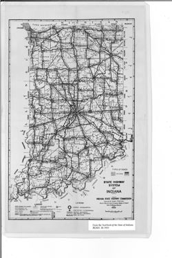
- Shows roads by general material type as well as boundaries and headquarters for districts and sub-districts. "H. D. Bodine - Sep. 28 '25." Detached from: Seventh annual report of the Indiana State Highway Commission for the fiscal year ending September 30, 1925 / State Highway Commission. In Year book of the State of Indiana for 1925 / The Legislative Reference Bureau. Indianapolis : Wm. B. Burford, contractor for state printing and binding, 1925.
- Call Number
- G4091.P2 1924 .I5
- Caption
- Imprint: [Indianapolis] : [The Legislative Bureau], [1925]
- Imprint: [Indianapolis] : [Wm. B. Burford, contractor for state printing and binding], [1925]
- Filename
- VAC3073-M-01038
- Subject
- Topical Subject: Administrative and political divisions
- Geographic Subject: Indiana
- Topical Subject: Roads
- Topical Subject: Road materials
- Title
- State highway system of Indiana [1924]
- Producer
- Bodine, H. D. (Harry D.), 1894-1942
- Indiana. State Highway Commission (1919-1953)
- Physical Description
- Scale: Approximately 1:1,370,000
- Dimensions: 35 x 22 cm, on sheet 40 x 25 cm
- Item Identifiers
- Alternate ID: 397754IP
- Title Control Number: a18455610
- Persistent Identifier
- Campus
- IU Bloomington
- Date Created
- 1925
- Provenance
- Year book of the state of Indiana (1925)
- Publisher
- Indiana. Legislative Bureau
Relationships
Relaciones
- En Collection:
Items
Show Item Images
| Miniatura | Título | Fecha de subida | Visibilidad | Acciones |
|---|---|---|---|---|
|
VAC3073-00305.jp2 | 2023-09-27 | Público |
|