
Image
Indiana Degonia Springs quadrangle Public Deposited
- Genre
- 15 minute topographic maps
- Topographic maps
- Quadrangle maps
- Location
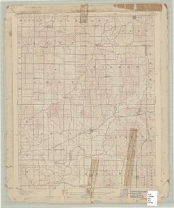
- Coordinates: W0871500 W0870000 N0381500 N0380000
- Related URL
- Abstract
- Engraved Oct. 1902 by U.S.G.S. , Jno. Renshawe, geographer in charge , control by Geo. T. Hawkins , topography by Chas. W. Goodlove. Filing title: Degonia Springs, Ind. Edition of Dec. 1902. Relief shown by contours and spot heights. Includes diagram of township. Contour interval 20 feet. Surveyed in 1900. Reprinted 1936.
- Call Number
- G4090 s62 .G4 Degonia Springs 1902
- Caption
- Imprint: Washington, D.C. : The Survey, 1902
- Filename
- VAC3073-M-01301
- Subject
- Geographic Subject: Spencer County (Ind.)
- Geographic Subject: Dubois County (Ind.)
- Geographic Subject: Warrick County (Ind.)
- Geographic Subject: Pike County (Ind.)
- Title
- Indiana Degonia Springs quadrangle
- Producer
- Renshawe, John H.
- Geological Survey (U.S.)
- Hawkins, Geo. T. (George T.)
- Goodlove, C. W.
- Physical Description
- Dimensions: 45 x 42 cm or smaller
- Scale: 1:62,500
- Item Identifiers
- Title Control Number: a18408290
- Persistent Identifier
- Campus
- IU Bloomington
- Date Created
- 1902
- Provenance
- Part of Geological Survey (U.S.). Indiana 1:62,500.
- Publisher
- Geological Survey (U.S.)
Relationships
Relationships
- In Collection:
Items
Show Item Images
| Thumbnail | Title | Date Uploaded | Visibility | Actions |
|---|---|---|---|---|
|
VAC3073-M-01301.jp2 | 2023-09-28 | Public |
|