
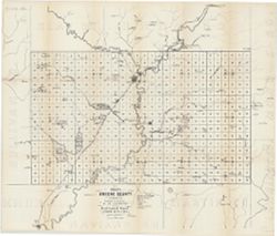
Image
Map of Greene County Öffentlichkeit Deposited
- Genre
- Thematic maps
- Location
- Coordinates: W0871431 W0864053 N0391018 N0385418
- Related URL
- Abstract
- Shows towns, railroads, coal and iron ore, mills, furnaces, and stone quarries. "For the first annual report of Prof. E.T. Cox, State Geologist." Detached from: First annual report of the Geological Survey of Indiana ... 1869. Indianapolis : Alexander M. Conner, 1869.
- Call Number
- G4093.G7H1 1869 .L3
- Caption
- Imprint: [Indianapolis] : [Alexander M. Conner], [1869]
- Filename
- VAC3073-M-01449
- Subject
- Topical Subject: Mines and mineral resources
- Geographic Subject: Greene County (Ind.)
- Topical Subject: IGS Annual Reports
- Title
- Map of Greene County
- Producer
- Levette, G. M. (Gilbert M.)
- Physical Description
- Dimensions: 61 x 71 cm
- Scale: Approximately 1:85,000
- Item Identifiers
- Title Control Number: a18189063
- Persistent Identifier
- Campus
- IU Bloomington
- Date Created
- 1869
- Provenance
- 1st Annual Report (1869) / Indiana. Geological Survey
- Publisher
- Indiana. Geological Survey
Relationships
Beziehungen
- In Collection:
Items
Show Item Images
| Miniaturansicht | Titel | Datum Hochgeladen | Sichtbarkeit | Aktionen |
|---|---|---|---|---|
|
VAC3073-M-01449.jp2 | 2023-09-28 | Öffentlichkeit |
|
|
VAC3073-00930.jp2 | 2023-09-28 | Öffentlichkeit |
|