
Image
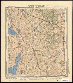
N-34-66-B-г Зигфридсвальде Public Deposited
- Genre
- Military Maps
- Topographic Maps
- Location
- Coordinates: 54, 20.625, 54.083, 20.75
- Related URL
- Abstract
- Modern area represented: Żegoty, Poland
- Call Number
- G7063.K2 s25 .S6 sheet N-34-66-C-d
- City
- Зигфридсвальде (Siegfriedswalde)
- Copyright Owner
- No Copyright - United States
- Country
- Германия (Восточная Пруссия) (Germany (East Prussia))
- Filename
- VAC9619-003813
- Subject
- Geographic Subject: Żegoty
- Topical Subject: Soviet Union
- Topical Subject: Maps
- Title
- N-34-66-B-г Зигфридсвальде
- Physical Description
- Scale: 1:25,000
- Language
- Russian
- Persistent Identifier
- Campus
- IU Bloomington
- Date Created
- 1941
- Provenance
- CIA Map Branch -- Received
- Publisher
- Генеральный штаб Красной Армии
Relationships
Relationships
- In Collection:
Items
Show Item Images
| Thumbnail | Title | Date Uploaded | Visibility | Actions |
|---|---|---|---|---|
|
VAC9619-003813.jp2 | 2024-02-09 | Public |
|