
Image
Illinois-Indiana Birds quadrangle : topography [1943 reprint] Public Deposited
- Genre
- Quadrangle maps
- Topographic maps
- 15 minute topographic maps
- Location
- Coordinates: W0874500 W0873000 N0390000 N0384500
- Related URL
- Abstract
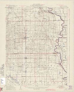
- R.B. Marshall, Chief Geographer , W.H. Herron, Geographer in charge , topography by F. Graff, Jr. , control by Corps of Engineers U.S. Army, U.S. Coast and Geodectic Survey, [and others]. Filing title: Ill.-Ind. Birds. Variant title: Birds quadrangle, Illinois-Indiana. Edition of 1917, reprinted 1943 with corrections. Polyconic projection. Relief shown by contours and spot heights. Shows Crawford County, Illinois, and small portions of Sullivan and Knox counties in Indiana. "Surveyed in 1914." "Surveyed in cooperation with the State of Illinois." "Culture revised in part, 1942." "N3845-W8730/15."
- Call Number
- G4090 s62 .G4 Birds 1917 R1943
- Caption
- Imprint: [Urbana, Ill.] : Geological Survey Division, [1943]
- Imprint: [Washington, D.C.] : U.S. Geological Survey
- Filename
- VAC3073-M-01316
- Subject
- Geographic Subject: Crawford County (Ill.)
- Geographic Subject: Sullivan County (Ind.)
- Geographic Subject: Knox County (Ind.)
- Title
- Illinois-Indiana Birds quadrangle : topography [1943 reprint]
- Producer
- U.S. Coast and Geodetic Survey
- United States. Army
- Graff, Fred, Jr.
- Herron, W. H. (William Harrison), 1865-
- Marshall, R. B. (Robert Bradford), 1867-1949
- Illinois State Geological Survey
- Physical Description
- Dimensions: 45 x 42 cm or smaller
- Scale: 1:62,500
- Item Identifiers
- Title Control Number: a18408527
- Persistent Identifier
- Campus
- IU Bloomington
- Date Created
- 1943
- Provenance
- Part of Geological Survey (U.S.). Indiana 1:62,500.
- Publisher
- Geological Survey (U.S.)
Relationships
Relationships
- In Collection:
Items
Show Item Images
| Thumbnail | Title | Date Uploaded | Visibility | Actions |
|---|---|---|---|---|
|
VAC3073-M-01316.jp2 | 2023-09-28 | Public |
|