
Image
Map of Vermillion County Öffentlichkeit Deposited
- Genre
- Geological maps
- Location
- Coordinates: W0873159 W0872113 N0400854 N0393626
- Related URL
- Abstract
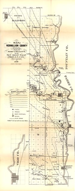
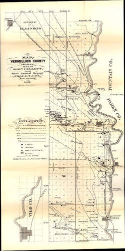
- Drawn by John Collett for the 1st annual report of Prof. E.T. Cox, State Geologist, 1869 , lith. by W & J. Braden. Shows towns, railroads, coal, mills, iron furnaces, timber, and prairie. Detached from: First annual report of the Geological Survey of Indiana, made during the year 1869.
- Call Number
- G4093.V4 1869 .C6
- Caption
- Imprint: [Indianapolis] : [Alexander H. Conner, State Printer], [1869]
- Imprint: [Indianapolis] : [Geological Survey of Indiana], [1869]
- Filename
- VAC3073-M-01158
- Subject
- Topical Subject: IGS Annual Reports
- Topical Subject: Coal mines and mining
- Topical Subject: Lumber trade
- Geographic Subject: Vigo County (Ind.)
- Topical Subject: Iron mines and mining
- Geographic Subject: Vermillion County (Ind.)
- Title
- Map of Vermillion County
- Producer
- Collett, John, 1828-1899
- Physical Description
- Dimensions: on sheet 77 x 32 cm
- Scale: Approximately 1:85,000. 3/4 of an inch to one mile
- Item Identifiers
- Title Control Number: a16799192
- Alternate ID: 390720IP
- Persistent Identifier
- Campus
- IU Bloomington
- Date Created
- 1869
- Provenance
- 1st Annual Report (1869) / Indiana. Geological Survey
- Publisher
- Indiana. Geological Survey
Relationships
Beziehungen
- In Collection:
Items
Show Item Images
| Miniaturansicht | Titel | Datum Hochgeladen | Sichtbarkeit | Aktionen |
|---|---|---|---|---|
|
VAC3073-M-01158.jp2 | 2023-09-27 | Öffentlichkeit |
|
|
VAC3073-00931.jp2 | 2023-09-27 | Öffentlichkeit |
|