
Image
Township 6 South, Range 3 West Public Deposited
- Genre
- Geological maps
- Geological cross-sections
- Location
- Coordinates: W0864825 W0863629 N0380227 N0375602
- Related URL
- Abstract
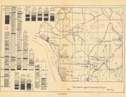
- ncludes index map and 16 stratigraphic columns showing coal measurements. Plate LXVII. "Troy. Tell City." Detached from: Seventh annual report of the Geological Survey of Indiana, made in the year 1875. Indianapolis : Sentinel Company, 1876. Page 1280.
- Call Number
- G4093.P2H9 1876 .T69
- Caption
- Imprint: [Indianapolis] : [Sentinel Company, printers], [1876]
- Imprint: [Indianapolis] : [Geological Survey of Indiana], [1876]
- Filename
- VAC3073-M-00991
- Subject
- Topical Subject: Mines and mineral resources
- Topical Subject: Geology
- Topical Subject: IGS Annual Reports
- Geographic Subject: Perry County (Ind.)
- Topical Subject: Coal
- Title
- Township 6 South, Range 3 West
- Physical Description
- Scale: Approximately 1:63,360. Vertical scale indeterminable
- Dimensions: on sheet 21 x 26 cm
- Item Identifiers
- Title Control Number: a18349350
- Alternate ID: 390726IP
- Persistent Identifier
- Campus
- IU Bloomington
- Date Created
- 1898
- Provenance
- 7th Annual Report (1875) / Indiana. Geological Survey.
- Publisher
- Indiana. Department of Geology and Natural Resources
Relationships
Relationships
- In Collection:
Items
Show Item Images
| Thumbnail | Title | Date Uploaded | Visibility | Actions |
|---|---|---|---|---|
|
VAC3073-00205.jp2 | 2023-09-27 | Public |
|