
Image
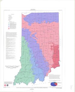
Map of Indiana showing locations of coal and industrial minerals operations Public Deposited
- Genre
- Geological maps
- Location
- Coordinates: W0880700 W0844500 N0414500 N0375200
- Related URL
- Abstract
- Includes pie chart and list of further reading. "1984 (Modified 1997)."
- Call Number
- G4091.H5 1997 .S5
- Caption
- Imprint: [Bloomington, Ind.] : Indiana Geological Survey, 1998.
- Filename
- VAC3073-M-00836
- Subject
- Geographic Subject: Indiana
- Topical Subject: Coal
- Topical Subject: Mines and mineral resources
- Title
- Map of Indiana showing locations of coal and industrial minerals operations
- Producer
- Shaffer, Nelson R.
- Physical Description
- Scale: 1:500,000
- Dimensions: 97 x 72 cm
- Item Identifiers
- Title Control Number: ALN0867BB
- Persistent Identifier
- Campus
- IU Bloomington
- Date Created
- 1998
- Publisher
- Indiana. Geological Survey
Relationships
Relationships
- In Collection:
Items
Show Item Images
| Thumbnail | Title | Date Uploaded | Visibility | Actions |
|---|---|---|---|---|
|
VAC3073-M-00836.jp2 | 2023-09-27 | Public |
|