
Image
Map of Jennings County Public Deposited
- Genre
- Cadastral maps
- Location
- Coordinates: W0854800 W0852700 N0391200 N0385500
- Related URL
- Abstract
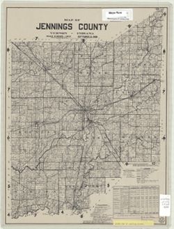
- Cadastral map showing landowners. Includes chart of "Jennings County statistics, 1930-1935, and lists of Board of County Commissioners, Board of County Councilman, and county officials.
- Call Number
- G4093.J6 G46 1939 .B88
- Caption
- Imprint: [Vernon, Ind.?] : [Jennings County?], [1939?]
- Filename
- VAC3073-M-00385
- Subject
- Topical Subject: Real property
- Geographic Subject: Jennings County (Ind.)
- Topical Subject: Landowners
- Title
- Map of Jennings County
- Producer
- Butler, Chas. T.
- Physical Description
- Dimensions: 47 x 35 cm
- Scale: 1:95,000
- Item Identifiers
- Title Control Number: a5541213
- Persistent Identifier
- Campus
- IU Bloomington
- Date Created
- 1939
- Publisher
- [Jennings County?]
Relationships
Relationships
- In Collection:
Items
Show Item Images
| Thumbnail | Title | Date Uploaded | Visibility | Actions |
|---|---|---|---|---|
|
VAC3073-M-00385.jp2 | 2023-09-25 | Public |
|