
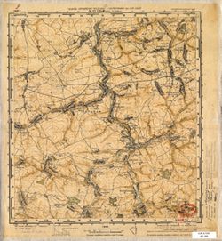
Image
N-37-109-C Верх. Путимец Public Deposited
- Original Publication Date
1940
- Genre
- Topographic Maps
- Military Maps
- Location
- Coordinates: 52.667, 36, 52.833, 36.25
- Related URL
- Abstract
- Modern area represented: Putimets, Oryol oblast, Russia
- Call Number
- G7000 s50 .S68 sheet N-37-109-C
- City
- Верх. Путимец (Verkhniy Putimets)
- Copyright Owner
- No Copyright - United States
- Country
- СССР (USSR)
- Filename
- VAC9619-001626
- Subject
- Geographic Subject: Verkhniy Putimets
- Topical Subject: Soviet Union
- Topical Subject: Maps
- State/Region
- Орловская область (Oryol oblast)
- РСФСР (RSFSR)
- Title
- N-37-109-C Верх. Путимец
- Physical Description
- Scale: 1:50,000
- Language
- Russian
- Persistent Identifier
- Campus
- IU Bloomington
- Date Created
- 1941
- Provenance
- DMA Topographic Center, Army Map Service Library, OMAHA, Library of Congress Geography & Map Division
- Publisher
- Главное Управление Геодезии и Картографии при СНК СССР
Relationships
Relationships
- In Collection:
Items
Show Item Images
| Thumbnail | Title | Date Uploaded | Visibility | Actions |
|---|---|---|---|---|
|
VAC9619-001626.jp2 | 2024-01-05 | Public |
|
|
VAC9619-U-000307.jp2 | 2024-01-05 | Public |
|