
Image
Indiana Oolitic quadrangle : 15-minute series [1960 reprint with vegetation] Public Deposited
- Genre
- 15 minute topographic maps
- Quadrangle maps
- Topographic maps
- Location
- Coordinates: W0864500 W0863000 N0390000 N0384500
- Related URL
- Abstract
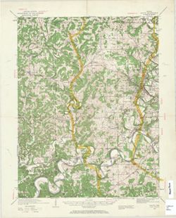
- Topography by W.K. McKinley [and seven others]. Polyconic projection. Relief shown by contours and spot heights. Contour interval 20 feet. Shows portion of Lawrence County, Indiana, as well as small portions of Martin, Green, and Monroe counties. Some copies show forest areas colored green. Surveyed in 1934-1935. Reprinted in 1960, 1964, and 1968. "Topography by W.K. McKinley, W.F. Chenault, J.O. Kilmartin, G.F. Westinghouse, Shirley Waggener, W.H. Austin, A.G. Kirk, and K.R. Garmong. Culture and drainage in part compiled from aerial photographs." "This area also covered by 1:24,000 scale maps of Oolitic, Owesnburg, Williams, and Bedford West 7.5-minute quadrangles, surveyed in 1957." "N3845--W8630/15."
- Call Number
- G4090 s62 .G4 Oolitic 1960 V
- Caption
- Imprint: Washington, D.C. : Interior--Geological Survey, 1960
- Filename
- VAC3073-M-01372
- Subject
- Geographic Subject: Greene County (Ind.)
- Topical Subject: Vegetation mapping
- Geographic Subject: Martin County (Ind.)
- Geographic Subject: Monroe County (Ind.)
- Geographic Subject: Lawrence County (Ind.)
- Title
- Indiana Oolitic quadrangle : 15-minute series [1960 reprint with vegetation]
- Producer
- McKinley, W. K. (William Klett), 1891-1964
- Geological Survey (U.S.)
- Physical Description
- Dimensions: 45 x 42 cm or smaller
- Scale: 1:62,500
- Item Identifiers
- Title Control Number: a18413831
- Persistent Identifier
- Campus
- IU Bloomington
- Date Created
- 1960
- Provenance
- Part of Geological Survey (U.S.). Indiana 1:62,500.
- Publisher
- Geological Survey (U.S.)
Relationships
Relationships
- In Collection:
Items
Show Item Images
| Thumbnail | Title | Date Uploaded | Visibility | Actions |
|---|---|---|---|---|
|
VAC3073-M-01372.jp2 | 2023-09-28 | Public |
|